Dynamic Planet
2027 season
On this page(11 sections)
Subsections
Dynamic Planet is an earth science event whose theme changes between seasons. In 2027 the theme is Earth's fresh waters: how water moves through the hydrologic cycle, how climate and landscape decide where it ends up, how rivers carve and fill their valleys, how groundwater, lakes and wetlands store it, how people change it, and how hydrologists measure it. The event rewards explaining a mechanism and doing short calculations: why a meander migrates, what a hydrograph shows about a basin, how fast groundwater moves between two wells. Memorized definitions alone leave many points on the table, because the rules award points for the quality of your reasoning as well as for correct answers.
Event format
| Rule | Detail |
|---|---|
| Team | Up to 2 students |
| Time | About 50 minutes |
| Calculators | Up to two Class II calculators per team (scientific, non-programmable, non-graphing; a Class I four-function model is also fine) |
| Writing utensils | Allowed |
| Binder | One binder, no size limit, with notes of any kind and origin; page protectors, laminated pages, tabs and labels are fine |
| Lab stations | If the event rotates through stations with samples, specimens or displays, nothing may be taken out of the binder at any point in the event |
| Test format | An exam, timed stations, or both |
| Scoring | High score wins; points for accurate answers, for the quality of supporting reasoning and for proper scientific method; preselected questions break ties |
Division B and Division C share the same rules text in 2027, so any difference between the divisions comes from how hard the supervisor writes the test. The 2026 Division C rule that binder material had to be fastened in the rings is gone from the 2027 wording; the station rule (nothing leaves the binder) still applies to both divisions.
The binder is your only reference, so build it for speed: a tabbed index that follows the rules outline below, one page of formulas with units, a page of worked calculations, and labeled diagrams of landforms, aquifers and hydrographs that you can match to an unlabeled figure on sight. Because the binder must stay intact at stations, tab it well rather than planning to pull pages out.
What the rules cover
The 2027 rules list eleven topic areas. Every item applies to both divisions and to every level of competition; nothing is marked State-only or National-only. The examples given in the rules are illustrations, not a closed list, so expect related terms too.
| Area | What it includes | Division |
|---|---|---|
| a. Hydrologic cycle | Fluxes such as precipitation, evaporation, transpiration, infiltration, runoff and condensation; storage reservoirs, residence time and water budgets; the critical zone | B and C |
| b. Climatic controls | Rainfall and snowfall patterns and seasonality; orographic lift, rain shadows, continentality, lake effect and elevation; the arid to humid spectrum and its landforms (ephemeral streams, playas, evaporites) | B and C |
| c. Drainage basins | Watersheds and divides, basin characteristics, stream order, drainage patterns, drainage density and texture | B and C |
| d. Sediment and channel form | Braided, meandering, straight and anastomosing channels and sinuosity; grain size, shape, sorting and rounding; bed, suspended and dissolved load, competence and capacity; ripples, dunes, antidunes and bars | B and C |
| e. Fluvial landforms | Longitudinal profile, gradient and base level; graded streams; knickpoints, waterfalls and V-shaped valleys; stream capture, downcutting, abrasion and hydraulic action; point bars, cut banks, oxbows, floodplains, levees, deltas and alluvial fans | B and C |
| f. Streamflow and floods | Perennial, intermittent and ephemeral flow; discharge, velocity and load; open-channel flow relationships; flood frequency and recurrence intervals | B and C |
| g. Groundwater and karst | Unsaturated and saturated zones; confined, unconfined and artesian aquifers, porosity and permeability; hydraulic gradient and flow; recharge, discharge and capillarity; surface water exchange and saltwater intrusion; karst landforms | B and C |
| h. Lakes and wetlands | Lake origins (tectonic, volcanic, glacial, fluvial damming); lake water budgets; stratification and turnover; shoreline processes; bogs, marshes, swamps and fens | B and C |
| i. Geologic record | Ripple marks, raindrop imprints, mud cracks, cross-bedding and graded bedding as flow indicators; paleochannels and old river and lake deposits | B and C |
| j. Human impacts | Land-use change; dams, levees, channelization, diversion and groundwater pumping (with depletion and subsidence); pollution types, sources and transport | B and C |
| k. Measurement | Reading topographic maps; mapping the water table from wells; stream gauging, rating curves and hydrographs; observation wells, tracers and remote sensing | B and C |
The 2027 rules manual for Dynamic Planet is in Division B pages B20 to B21 and Division C pages C24 to C25. The rules name no specimen list and no required equations; the formulas below are the standard ones that the outline's calculation items (sinuosity, discharge, flow relationships, recurrence intervals, hydraulic gradient) call for.
Rotation: what changed from 2026
Dynamic Planet cycles through themes such as glaciers, tectonics, oceanography and fresh waters. The 2026 season covered physical and geological oceanography: seawater, currents, waves, tides and the seafloor. None of that is in the 2027 rules. Ocean circulation, tides, plate tectonics and glaciers are not tested topics this year; glacial and tectonic ideas appear only as ways that lakes form, and the ocean appears only where it meets fresh water (saltwater intrusion, deltas, base level).
Fresh waters was last the theme in the 2021-22 and 2022-23 seasons, so most archived tests from those years match the 2027 content closely. Compared with those seasons, the 2027 outline puts more weight on climatic controls, the critical zone, bedforms and the sedimentary record, flood frequency and field measurement, so study those areas beyond what the older tests show.
Core mechanisms across the outline
A few ideas connect almost every rules area. Learn them first, then hang the vocabulary on them. The Earth's Fresh Waters guide treats each one in depth.
Budgets and residence time (area a, h)
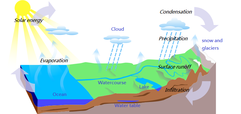
Any reservoir, whether a lake, an aquifer or a whole basin, obeys one rule: inputs − outputs = change in storage. For a basin over a year, precipitation = evapotranspiration + runoff + change in storage. The critical zone is the thin outer skin of the land, from the top of the vegetation down to the base of groundwater, where rock, soil, water, air and living things interact; it controls how rainfall splits between infiltration, evapotranspiration and runoff. Residence time tells you how long a water molecule stays in a reservoir on average: large, slowly fed reservoirs (deep aquifers, large lakes) hold water for years to thousands of years, while rivers and the atmosphere turn over in days to weeks.
Climate sets the supply (area b)
Rising air cools and drops its moisture, so the windward side of a mountain range is wet and the lee side sits in a rain shadow. Interiors far from the ocean (continentality) get less moisture and larger temperature swings. Cold air crossing a large, warmer lake picks up heat and moisture and dumps lake-effect snow downwind. Where evaporation exceeds precipitation, streams become ephemeral, basins have no outlet, and lakes dry into playas crusted with evaporites such as halite and gypsum.
Rivers do work with excess energy (areas c to f)
A stream's energy comes from its fall in elevation. Steep headwaters cut down, making V-shaped valleys and knickpoints; lower reaches, with gentle gradients and more discharge, spend their energy moving sediment sideways and building floodplains. A graded stream has adjusted its slope so that it just carries the load supplied to it. Lower the base level (a falling lake, a dropped sea level, an uplift) and the stream cuts down again, sending a knickpoint migrating upstream.
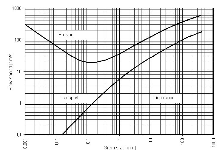
Competence is the largest grain a flow can move; capacity is the total load it can carry. Both rise steeply with velocity. Bedforms record the flow: at low velocity the bed forms ripples, then dunes; near the critical flow speed it planes out, and above it antidunes form in step with surface waves. On a meander, fast water on the outside of the bend cuts the cut bank while slow water on the inside deposits the point bar, so the bend migrates until a neck cutoff leaves an oxbow lake.
Groundwater moves down the head gradient (area g)
Below the water table every pore is full (the zone of saturation); above it pores hold air and water (the zone of aeration), with a capillary fringe just above the table. Porosity is how much space there is; permeability is how well that space is connected. Clay has high porosity and very low permeability, which is why it makes a confining layer. Water flows from high to low hydraulic head, at right angles to head contours, at a rate given by Darcy's law. In karst, slightly acidic water dissolves limestone, so streams vanish into sinkholes, flow through caves and reappear at springs.

Lakes, wetlands and the rock record (areas h, i)
Lakes form wherever a closed depression meets a water supply: rifts (Baikal), volcanic craters and calderas (Crater Lake), glacial scour and kettles, and rivers cut off or dammed. Fresh water is densest near 4 °C, so a temperate lake stratifies in summer (warm epilimnion over cold hypolimnion) and turns over when the surface reaches the same temperature as the deep water. Wetlands are told apart by water source and plants: bogs are rain-fed, acidic and peaty; fens are groundwater-fed peatlands; marshes are dominated by grasses and reeds; swamps by trees and shrubs.
Old water leaves evidence. Asymmetric ripple marks point downcurrent with their steep face, while symmetric ones mean waves sloshing back and forth. Mud cracks and raindrop imprints mean soft sediment was exposed to air. Cross-bedding records migrating ripples or dunes and dips toward where the current went. Graded bedding, coarse at the base and fining upward, records a waning flow and tells you which way was up.
People change the pathways (areas j, k)
A storm hydrograph splits streamflow into baseflow, the steady groundwater contribution that keeps a perennial stream running between storms, and stormflow (quickflow), the runoff pulse that rises to the peak discharge; lag time runs from peak rainfall to peak discharge. Paving and drainage raise runoff, so the hydrograph gets a higher, earlier peak and a shorter lag time. Dams trap sediment, so the clear water released below can scour and downcut the channel; levees and channelization confine floods and pass them downstream. Pumping faster than recharge depletes aquifers and lets compressible clays compact, causing subsidence; near coasts it draws salt water inland. To measure all of this, hydrologists record stage continuously at a gauge and convert it to discharge with a rating curve built from many velocity-times-area measurements, and they map the water table by contouring heads from observation wells.
Formulas you will use
| Quantity | Formula | Units |
|---|---|---|
| Discharge | m³/s (area in m², velocity in m/s) | |
| Sinuosity | none; above about 1.5 is usually called meandering | |
| Drainage density | km/km² | |
| Recurrence interval | years ( = years of record, = rank of the flood) | |
| Hydraulic gradient | none (head difference over flow distance) | |
| Darcy's law | m³/day with in m/day | |
| Residence time | time |
Study plan
- Week 1: the hydrologic cycle, budgets, residence time and climatic controls (areas a and b). Practice a basin budget and a lake residence time.
- Week 2: drainage basins and stream channels (areas c and d): stream order, drainage patterns, sinuosity, sediment properties, Hjulström reading and bedforms.
- Week 3: fluvial landforms and streamflow (areas e and f): long profiles, base level, meander landforms, discharge, Manning's equation and flood frequency.
- Week 4: groundwater and karst (area g): head, Darcy's law, aquifer types, cones of depression, saltwater intrusion and karst features.
- Week 5: lakes, wetlands and the sedimentary record (areas h and i), then human impacts and measurement (areas j and k): hydrographs, rating curves, water-table contour maps and topographic map reading.
- Ongoing: timed tests from the 2021-22 and 2022-23 seasons, with every miss logged in the binder index by rules area.
Common pitfalls
How tournaments test this
The Scio.ly archive holds 3,304 public-test Dynamic Planet questions, almost all from the freshwater seasons: 1,430 from 2021-22 and 1,733 from 2022-23, plus 141 from a 2017 test. By subtopic tag the largest groups are Rivers (1,311), Groundwater (894), Lakes (578), Hydrology (526) and Pollution (231). The practice bank adds 7,339 questions, also mostly freshwater: Hydrology (2,243), Groundwater (1,919), Rivers (1,650) and Pollution (1,073).
- Formats. 54% of archived questions are free response, 37% multiple choice, 4% select-all, 2% true/false and 2% numeric. Free response is where reasoning points are won or lost.
- Tasks. The largest share asks you to explain why (11.6%), then "which of the following" (9.7%), interpreting a graph, table or curve (3.6%), calculating (3.0%), defining a term (2.3%) and comparing (1.8%).
- Recurring terms. Drainage pattern (151 questions), karst topography (91), hydraulic conductivity (82), stream order (78), Darcy's law (69) and base level (68) come up again and again.
- Most common correct answers. Limestone (45 questions), clay (37), meandering (24), "increases" (22) and bed load (21).
- Source tournaments. The largest contributors are the Rickards Science Olympiad Invitational (2023, 309 questions) and the Lexington Invitational (2022, 194).
Older tests underweight the areas the 2027 outline adds or stresses (climatic controls, the critical zone, bedforms, the sedimentary record, flood frequency, hydrographs and gauging), so write your own practice items for those from the mechanisms above.
Test yourself
Real questions from public freshwater-season tests, each with an official answer key, spread across the 2027 rules areas.
- 1
Which of these is/are true about Earth’s water and hydrologic cycle?
I. In the oceans, overall precipitation balances overall evaporation II. Most freshwater is contained in glaciers and ice III. Energy from the Sun drives the hydrologic cycle
Practice more Dynamic Planet questions →
- 1
Which of the following factors affect water infiltration of a formation?
Practice more Dynamic Planet questions →
Subtopic guides under this event
- Earth's Fresh Waters: the 2027 theme in depth: watersheds and drainage networks, river flow, sediment and channel form, lakes and wetlands, groundwater and wells, karst, and water quality.
References and further reading
- Science Olympiad, Dynamic Planet event page and the 2027 rules manual: https://www.soinc.org
- USGS Water Science School (water cycle, groundwater, streamflow and gauging): https://www.usgs.gov/special-topics/water-science-school
- USGS, how streamflow is measured (stage, rating curves and discharge): https://www.usgs.gov/special-topics/water-science-school/science/how-streamflow-measured
- USGS, floods and recurrence intervals: https://www.usgs.gov/special-topics/water-science-school/science/floods-and-recurrence-intervals
- NOAA National Weather Service, lake-effect snow: https://www.weather.gov/safety/winter-lake-effect-snow
- Critical Zone Collaborative Network, what the critical zone is: https://criticalzone.org
- SciOly Wiki, Dynamic Planet (another summary of the event): https://scioly.org/wiki/index.php/Dynamic_Planet
- Fetter, C. W., Applied Hydrogeology, and Leopold, Wolman and Miller, Fluvial Processes in Geomorphology, standard references for Darcy's law and channel form.
- Practice more: the Scio.ly test archive has public Dynamic Planet tests from the freshwater seasons.
Official references
Sample notesheet
Download a printable, rule-compliant sample notesheet. Customize with your notes.