Dynamic Planet - Earth's Fresh Waters
On this page(18 sections)
Earth's fresh waters (rain, rivers, lakes, wetlands and groundwater) are the whole of Dynamic Planet in the 2027 rules. Questions treat them as one system. Climate decides how much water arrives, basins route it into channels, channels sort and deposit sediment, lakes and aquifers store it, and people pump, dam and pollute it. Three ideas explain most of the event. Water moves down a gradient (of elevation in a channel, of hydraulic head underground). Flow speed decides what water can carry. Storage and flux decide how long water stays anywhere.
What the rules cover
The 2027 rules manual (pages B20–B21 and C24–C25) gives one outline of eleven areas, identical for both divisions, with no level restrictions. The examples it lists are only examples, so expect related terms too.
| Rules area | What it covers | Levels | Divisions |
|---|---|---|---|
| a. Hydrologic cycle, water budgets, critical zone | Cycle processes and fluxes; reservoirs, residence times, budgets | All | B and C |
| b. Climatic controls | Precipitation inputs; orographic, rain shadow, continentality, lake effect, elevation; arid to humid landscapes (ephemeral streams, playas, evaporites) | All | B and C |
| c. Drainage basins and networks | Watersheds, divides, basin traits; stream order; drainage pattern, density, texture | All | B and C |
| d. Sediment and channel form | Channel planform and sinuosity; grain size, shape, sorting, rounding; load types, supply, competence, capacity; bedforms | All | B and C |
| e. Fluvial landforms and valleys | Long profile, gradient, base level; graded streams; knickpoints, waterfalls, V-shaped valleys; erosion processes and stream capture; floodplain landforms, deltas, fans | All | B and C |
| f. Streamflow and floods | Perennial, intermittent, ephemeral flow; discharge, velocity, load; open-channel flow equations; flood frequency and recurrence | All | B and C |
| g. Groundwater and karst | Subsurface zones; aquifer types, porosity, permeability; hydraulic gradient and flow; recharge, discharge, capillarity; surface water–groundwater exchange and saltwater intrusion; karst | All | B and C |
| h. Lakes and wetlands | Lake origins; lake water budgets; physical and chemical properties and turnover; shoreline processes; wetland types | All | B and C |
| i. Geologic and paleohydrologic record | Sedimentary structures that record flow; paleochannels; old river and lake deposits | All | B and C |
| j. Human impacts and water quality | Land-use change; dams, levees, channelization, diversion, pumping, depletion, subsidence; pollution types, sources, transport | All | B and C |
| k. Measuring and monitoring | Topographic maps; water-table maps from wells; stream gauging and hydrographs; monitoring networks and tracers, remote sensing | All | B and C |
Event format
Teams of up to 2 have about 50 minutes for an exam, timed stations, or both. Each team may bring writing utensils, up to two Class II calculators (stand-alone scientific calculators that are neither graphing nor programmable; a simpler Class I model is also fine) and one binder of any size with any content; sheet protectors, lamination, tabs and labels are allowed. At a station rotation with samples or displays, nothing may leave the binder during the event, so make pages readable in place. High score wins. Graders credit accurate answers, sound reasoning and correct scientific method, so show your setup and explain your reasoning. Preselected questions break ties.
The hydrologic cycle, water budgets and the critical zone
The hydrologic cycle moves water between reservoirs through fluxes. Evaporation and transpiration (together, evapotranspiration) lift water into the air. Condensation forms clouds, and precipitation returns water to the surface. Water on land then splits between runoff, which reaches streams within hours, and infiltration, which soaks into soil and may percolate down to groundwater and reach a stream weeks to centuries later. Sunlight drives the cycle and gravity returns the water downhill. Below a certain depth every pore in the ground is full of water; the top of that saturated zone is the water table (explained fully under Groundwater).
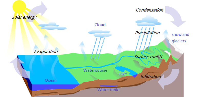
Properties of water that drive the cycle
Many "easy" questions are really about the water molecule. A water molecule is polar (the oxygen end is slightly negative, the hydrogen ends slightly positive), so neighboring molecules cling together by hydrogen bonds. Almost every unusual property follows from that.
| Property | Value or fact | Why it matters for fresh water |
|---|---|---|
| Maximum density | About 4 °C (1.000 g/cm³) | The bottom of a deep lake stays near 4 °C all winter; lakes freeze from the top down |
| Ice density | About 0.92 g/cm³; water expands about 9% on freezing | Ice floats and insulates lakes; freeze–thaw (frost wedging) splits rock. Ice is less dense than liquid water at any temperature, so solid ice at about 0.92 g/cm³ is the least dense condensed form of fresh water |
| Specific heat | 4.18 J/(g·°C), very high | Lakes warm and cool slowly and moderate nearby climate |
| Latent heat | Evaporation absorbs about 2,260 J/g (at 100 °C; more at lower temperatures); condensation releases the same | Evaporation cools surfaces; condensation in clouds releases heat that powers storms |
| Cohesion and surface tension | Molecules attract one another | Drops, menisci, insects walking on water |
| Adhesion | Water attracts other surfaces | With cohesion, causes capillary rise in soil pores and narrow tubes (a concave meniscus) |
| Solvent power | Dissolves more substances than any common liquid | Rivers carry a dissolved load; groundwater dissolves limestone |
| Viscosity | Falls as temperature rises | Warm water flows and drains slightly more easily |
Common definitions also show up directly. Fresh water has less than about 1,000 mg/L (1,000 ppm) of dissolved solids, by the USGS definition; brackish water is a mix of fresh and salt water; seawater averages about 35,000 mg/L (35‰). Potable water is safe to drink. Brackish and salty water is of little direct use: drinking it dehydrates the body, it salinizes irrigated soil and harms crops, and it corrodes pipes and equipment, so it must be desalinated first. Hard water carries a lot of dissolved calcium and magnesium (it leaves scale and resists soap lather); soft water carries little.
| Dissolved solids (mg/L) | USGS class |
|---|---|
| Below 1,000 | Fresh |
| 1,000–3,000 | Slightly saline |
| 3,000–10,000 | Moderately saline |
| 10,000–35,000 | Highly saline |
| About 35,000 | Seawater |
Processes of the cycle
| Process | Change | Notes |
|---|---|---|
| Evaporation | Liquid → vapor | Absorbs latent heat; about 85–90% of atmospheric moisture comes from evaporation, mostly from the ocean |
| Transpiration | Liquid in plants → vapor from leaf stomata | Most of the remaining moisture; a large share of evaporation from vegetated land |
| Evapotranspiration (ET) | Evaporation + transpiration | Potential ET is what would occur with unlimited water; actual ET is what does occur. In deserts potential ET far exceeds actual ET |
| Sublimation | Solid → vapor, skipping liquid | Snow and ice shrink on dry, sunny, windy days without melting |
| Deposition (desublimation) | Vapor → solid | Frost; the reverse of sublimation |
| Condensation | Vapor → liquid | Forms clouds, fog and dew when air cools to its dew point; releases latent heat |
| Precipitation | Water falls from clouds | Rain, snow, sleet, hail, freezing rain, drizzle |
| Interception | Leaves and stems catch precipitation | Some evaporates (interception loss); the rest drips through as throughfall or runs down trunks as stemflow |
| Infiltration | Water enters the soil surface | Limited by infiltration capacity |
| Percolation | Water moves down through soil and rock by gravity | Carries water from the soil to the water table (recharge) |
| Runoff | Water flows over the land or in channels | Feeds streams quickly |
| Interflow (throughflow) | Water moves sideways through the soil above the water table | Reaches streams more slowly than overland flow |
| Baseflow | Groundwater seeps into a channel | Keeps perennial streams flowing in dry weather |
| Advection | Wind carries vapor sideways | Moves ocean moisture over land |
Relative humidity is the amount of water vapor in the air compared with the most it could hold at that temperature. At 100% (saturation), evaporation and condensation over a water surface are in dynamic equilibrium: molecules leave and return at equal rates.
Three global budget facts recur on tests: (1) over the oceans, evaporation exceeds precipitation; (2) over the land, precipitation exceeds evapotranspiration; (3) the difference, roughly 40,000 km³ a year, is carried from sea to land as vapor and returns to the sea as river and groundwater runoff. So over land, P > ET > runoff, and over the long term P = ET + Q (runoff), with storage changes averaging out. Precipitation is the main input to any land water budget, and the Sun (evaporation) and gravity (precipitation, runoff) drive the cycle.
Infiltration and runoff
Infiltration capacity is the fastest rate at which soil can absorb water. If rain falls more slowly than that rate, all of it soaks in. When rain falls faster, the excess pools and runs off. Capacity depends on the soil texture, vegetation cover, compaction and how wet the soil already is. Wind and soil acidity do not affect it. Rain is classed as light below about 2.5 mm per hour, and intensity matters as much as total amount: the same 50 mm of rain soaks in over two days but floods a basin in two hours.
Overland flow forms in two ways. Infiltration-excess (Hortonian) overland flow happens when rain falls faster than the soil can absorb it: intense storms on clay, bare, crusted or paved ground. Saturation-excess overland flow happens when the soil is already full, so even gentle rain runs off, typically in valley bottoms and near streams after long wet spells. Sand absorbs water fast and drains quickly; clay absorbs slowly, produces more runoff in intense rain, and stays wet longer afterward.
| Change in the basin | Infiltration | Runoff and flooding |
|---|---|---|
| Deforestation or wildfire | Down (bare, crusted soil; no interception) | Up, with more erosion and sediment |
| Urban pavement and roofs | Way down | Up sharply; faster, higher peaks |
| Soil compaction (machinery, grazing) | Down | Up |
| Gentler slope with loose soil | Up | Down |
| Frozen or saturated ground | Near zero | Up |
| Wetlands and forest cover | Up (more storage) | Down; flood peaks delayed |
Some rain is held briefly in puddles and surface hollows (depression storage) before it evaporates or infiltrates.
Soil water. After heavy rain, gravity drains the large pores within a day or two. The water the soil still holds against gravity is its field capacity. Plants keep drawing water out until the wilting point, when the rest is held too tightly to extract. Plant-available water is field capacity minus wilting point; silt loams hold the most, sands the least. Water in the unsaturated zone moves by both gravity and capillarity. The thin films that cling to grain surfaces are held by adhesion (molecular attraction between water and mineral surfaces); capillarity is the combined effect of adhesion and cohesion in narrow pores. Note the overlap in terms: infiltration is entry of water into the soil surface (and is often used loosely for movement into the soil), while percolation is the continued downward movement through soil and rock; read the question's wording carefully.
The SMAP (Soil Moisture Active Passive) satellite, launched by NASA in 2015, measures surface soil moisture with an L-band radiometer, and its readings are combined with models (data assimilation) to estimate root-zone soil moisture. Soil moisture tension (matric potential, or suction) is how tightly water is held by soil particles; it is low (near zero) in wet soil and rises as soil dries, so it tells how hard plants must work to extract water (field capacity is roughly −33 kPa, the wilting point about −1,500 kPa). Soil moisture is expressed as gravimetric water content (mass of water ÷ mass of dry soil), volumetric water content (volume of water ÷ total soil volume) or soil water potential (how tightly it is held). Measuring soil moisture. The gravimetric method weighs a soil sample before and after oven-drying. Field sensors include tensiometers (a water-filled tube with a porous ceramic tip that reads soil-water tension, or suction), gypsum (resistance) blocks and granular matrix sensors (electrical resistance changes with wetness), heat-dissipation sensors, time-domain reflectometry and capacitance probes (dielectric constant), and neutron probes. Satellites (SMAP) and airborne radiometers map soil moisture from space. Soil-moisture data help forecast floods and droughts, schedule irrigation and predict crop yields.
Reservoirs and residence time
About 96.5% of Earth's water is ocean (about 97.5% is salty, counting saline lakes and groundwater). Of the roughly 2.5% that is fresh, most is ice and most of the rest is groundwater; rivers and lakes hold well under 1%. A reservoir's residence time is the average time water stays in it: volume divided by flux.
The USGS breakdown (based on Shiklomanov's estimates) is the one most tests copy:
| Share | Where |
|---|---|
| About 96.5% of all water | Oceans (with saline groundwater and lakes, about 97.5% of all water is salty) |
| About 2.5% of all water | Fresh water |
| 68.7% of fresh water | Glaciers, ice caps and permanent snow |
| 30.1% of fresh water | Groundwater |
| 1.2% of fresh water | Surface and other fresh water |
| Of that 1.2% | Ground ice and permafrost 69%, lakes 20.9%, soil moisture 3.8%, atmosphere 3.0%, swamps and marshes 2.6%, rivers 0.49%, living things 0.26% |
So the order of fresh-water stores is ice caps and glaciers > groundwater > ground ice and permafrost > lakes > soil moisture > atmosphere > swamps and marshes > rivers > living things; for liquid surface water alone, lakes hold far more than rivers. Fresh water is often rounded to about 3% of Earth's water. Only about 1% of all Earth's water (as little as about 0.5% by stricter definitions) is liquid fresh water that people can readily reach and use. Groundwater is by far the largest usable store of liquid fresh water. Rivers hold the least water at any moment but move it fastest. The Great Lakes hold about 21% of the world's fresh surface water and about 84% of North America's.
| Reservoir | Typical residence time | Why |
|---|---|---|
| Atmosphere | About 9 days | Small store, very fast fluxes |
| Rivers | Weeks to months | Water drains to the sea quickly |
| Soil moisture | Weeks to months | Lost to evapotranspiration and drainage |
| Seasonal snow | Months | Melts each spring |
| Large lakes | Years to centuries | Large volume relative to outflow |
| Groundwater | Decades (shallow) to over 10,000 years (deep) | Slow flow through pores |
| Mountain glaciers | Decades to centuries | Moderate store, steady melt |
| Oceans | A few thousand years (about 2,300–3,400 depending on the flux used) | Enormous volume |
| Ice sheets | Up to hundreds of thousands of years | Water locked as ice |
Published values vary by source, so treat these as orders of magnitude. The order from shortest to longest (atmosphere < rivers ≈ soil < lakes < shallow groundwater < oceans < deep groundwater and ice sheets) is what multiple-choice questions test. A pollutant's residence time follows the water's: it flushes from a river in weeks, but can stay in deep groundwater for centuries.
Water budgets
A water budget applies conservation of mass to a basin, lake or aquifer: what comes in, minus what goes out, equals the change in storage.
The same bookkeeping works for any control volume once you list every input and output. The USGS writes the general form as inflow = outflow + change in storage:
The critical zone
The critical zone is Earth's thin outer skin, from the treetops down to the base of weathered rock and groundwater, where rock, soil, water, air and life interact. Nearly every flux in the budget passes through it: roots draw soil water up for transpiration, soil pores set infiltration, and weathering supplies a river's dissolved load.
From top to bottom it runs through vegetation, soil (horizons O, organic litter; A, topsoil; E, leached layer; B, subsoil where clay and iron accumulate; C, weathered parent material; R is bedrock), loose weathered material called regolith (including saprolite, rock rotted in place), and then fresh bedrock. The water table usually lies somewhere within it. Consolidated materials are solid rock (granite, sandstone); unconsolidated materials are loose sediment (sand, gravel, alluvium, glacial till).
Weathering breaks rock down in place; erosion moves the pieces. The agents of erosion are running water (by far the most important on land), glaciers, wind (deflation of fine particles and sandblasting abrasion, important in deserts), waves and currents, groundwater (dissolution), and gravity (mass wasting: rockfalls, slides, slumps, creep, debris flows). Both feed rivers with sediment and solutes.
| Weathering type | Process | Example |
|---|---|---|
| Physical: frost wedging (freeze–thaw) | Water in cracks expands about 9% when it freezes and pries rock apart | Angular scree below cliffs in cold climates |
| Physical: exfoliation (unloading) | Rock released from burial expands and peels in sheets | Granite domes such as Half Dome |
| Physical: abrasion | Grains carried by water, wind or ice grind rock | Smoothed river pebbles |
| Chemical: dissolution and carbonation | Carbonic acid dissolves calcite | Limestone caves and karst |
| Chemical: hydrolysis | Water reacts with feldspar to make clay | Rotted granite (saprolite) |
| Chemical: oxidation | Iron minerals rust | Red and yellow soils |
| Biological | Roots pry cracks; lichens and microbes release acids | Tree roots splitting sidewalks |
Chemical weathering is fastest where it is warm and wet. Minerals that crystallize at high temperature weather fastest (Goldich's series): olivine is the least stable common silicate and quartz the most stable, which is why quartz sand survives long river journeys.
Soil forms under five factors, remembered as CLORPT: climate, organisms, relief (topography), parent material and time; climate (temperature and precipitation) is usually the most important over large regions, but parent material sets inherited properties such as mineral content, texture and color, and dominates in young soils. A typical healthy loam is roughly 45% mineral matter, 5% organic matter, 25% water and 25% air by volume. Soil depth to bedrock or to a dense, impermeable layer (a hardpan or fragipan) controls how much water a soil can store: thin soils over rock fill quickly, saturate, and shed saturation-excess runoff, while deep soils absorb long storms. Soil texture is the mix of sand, silt and clay; a loam has roughly balanced proportions and good drainage and water retention. Clay-rich soils have high porosity but tiny pores, so they drain slowly and run off in heavy rain. Sandy soils drain fast and hold little water.
The Universal Soil Loss Equation estimates sheet and rill erosion from fields: , where R is rainfall erosivity, K soil erodibility, LS the slope length and steepness factor, C the cover (vegetation) factor and P the conservation-practice factor. Loose sediment piles up only to its angle of repose, the steepest stable slope: about 30–35° for dry sand, steeper (up to about 40° or more) for coarse, angular fragments. Wetting with a little water adds cohesion; saturation removes it and triggers slope failure. Farmers cut soil erosion with contour plowing, terracing steep slopes, strip cropping (alternating row crops with close-growing crops), cover crops, no-till or conservation tillage, windbreaks, and grassed waterways and riparian buffers. Rain erodes soil in stages: splash erosion (drops dislodge grains), sheet erosion (a thin film of runoff), rill erosion (small channels) and gully erosion (deep channels).
Climatic controls on fresh water
Climate sets how much water arrives and when. Seasonality decides whether streams flow all year, snowfall stores winter precipitation for a spring melt pulse, and intensity decides whether rain infiltrates or runs off. Precipitation also varies across space: totals change with latitude, distance from moisture sources and terrain, so isohyet maps (lines of equal precipitation) are a common figure.
Topography and geography
- Orographic lift. Moist air forced up a mountain range cools as it expands. Its vapor condenses, so the windward slope is wet.
- Rain shadow. After crossing the crest, the dried air sinks and warms by compression, so the leeward side is dry. Deserts east of the Sierra Nevada and the Cascades are classic rain shadows.
- Continentality. Interiors far from the ocean receive less moisture and have larger temperature swings than coasts.
- Lake effect. Cold, dry air crossing a large unfrozen lake picks up heat and moisture and drops heavy snow on the downwind shore, as on the eastern and southern shores of the Great Lakes.
Elevation adds to all four: mountains usually get more precipitation than lowlands and store it as snowpack that feeds summer rivers.
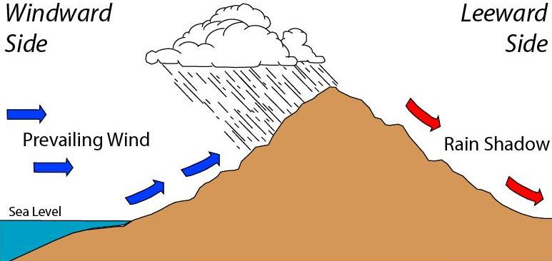
How air makes precipitation
Precipitation needs rising air: air expands and cools as it rises, and once it cools to its dew point, vapor condenses. Unsaturated air cools at the dry adiabatic lapse rate, about 9.8 °C per km. Saturated air cools more slowly, at roughly 5–6 °C per km (the moist or saturated rate), because condensation releases latent heat. That difference is why the leeward side of a range is both drier and warmer than the windward side at the same elevation: the air lost its water (and gained latent heat) on the way up, then warms at the dry rate on the way down. These warm, dry downslope winds are called foehn winds, or chinooks east of the Rockies.
| Lifting mechanism | What forces air up | Typical precipitation |
|---|---|---|
| Convective | Surface heating makes buoyant air rise | Short, intense summer thunderstorms; flash floods |
| Frontal (cyclonic) | Warm air rides over cold air at a front | Widespread, long-lasting rain or snow |
| Orographic | Wind pushes air up a mountain slope | Heavy, persistent precipitation on windward slopes |
| Convergence | Air streams meet and rise, as at the equator (ITCZ) | Daily tropical rain |
Large-scale circulation sets the background. Rising air near the equator gives the wet tropics; sinking air near 30° N and S (the descending limb of the Hadley cell) gives the great subtropical deserts. Monsoons reverse seasonal winds and bring a wet summer to South Asia and the U.S. Southwest. In the contiguous United States the wettest regions are the Pacific Northwest coast and the Southeast (Gulf Coast); the driest is the desert Southwest. If all of Earth's glaciers and ice sheets melted, sea level would rise by roughly 70 m. A common working definition of a desert is a place receiving less than about 250 mm (10 in) of precipitation a year.
How raindrops form. Vapor condenses on tiny condensation nuclei (dust, salt, smoke) to make cloud droplets about 0.01–0.02 mm across, far too small to fall. Droplets grow into raindrops by collision–coalescence (larger drops fall faster and sweep up smaller ones, the main process in warm clouds) or by the Bergeron (ice-crystal) process (ice crystals grow at the expense of supercooled droplets, then fall and melt). Drops must be large enough to survive evaporation on the way down. Measuring precipitation. Rain gauges measure it directly at a point. Weather radar (NEXRAD in the U.S.) bounces microwaves off raindrops and converts the reflectivity into rainfall intensity over a wide area. Satellites infer precipitation from cloud-top temperature and from passive microwave and space-borne radar measurements (for example the GPM mission), so radar and satellites do not measure rain in the same way. An isohyet map connects points of equal precipitation.
Drought is a prolonged shortage of water relative to normal. Its stages are meteorological (below-normal precipitation), agricultural (soil moisture too low for crops), hydrological (low streamflow, reservoir, lake and groundwater levels, which lag behind the rain deficit) and socioeconomic (demand exceeds supply). In a drought, soil moisture falls first, evapotranspiration drops as plants close stomata and wilt, streams shrink to baseflow or dry up, losing streams increase, water tables decline (made worse by extra pumping), lakes shrink and concentrate salts and pollutants, and warmer, lower water holds less oxygen. Dry, hardened or water-repellent soil can then increase runoff when rain returns.
Cold regions: snow, ice and permafrost
Snow water equivalent (SWE) is the depth of water the snowpack would yield if melted; fresh snow is often about 10:1 (10 cm of snow → 1 cm of water), but ratios range from about 5:1 for wet snow to 20:1 or more for powder. SWE is measured with snow courses (coring by hand), automated snow pillows (the USDA SNOTEL network across the western U.S.) and satellites, and it is used to forecast spring runoff and water supply. Glacial hydrology is split by position: supraglacial (meltwater on the ice surface: streams, lakes, moulins), englacial (inside the ice), subglacial (at the glacier bed, which lubricates sliding), proglacial (in front of the ice: outwash, braided rivers, ice-marginal lakes), plus postglacial for water and landforms left after the ice retreats. In cold climates winter precipitation is stored as snowpack and released in a spring snowmelt pulse, so many western U.S. rivers peak in late spring. Permafrost is ground that stays at or below 0 °C for at least two consecutive years.
| Term | Meaning |
|---|---|
| Continuous / discontinuous / sporadic / isolated permafrost | Underlies more than 90% / 50–90% / 10–50% / less than 10% of the land area |
| Active layer | The top layer that thaws each summer and refreezes each winter |
| Talik | A layer or body of unfrozen ground within or beneath permafrost, often under lakes and rivers; it can be open (connecting to unfrozen ground below) or closed |
| Pingo | An ice-cored hill pushed up by freezing groundwater. Open-system (hydraulic) pingos are fed by groundwater flowing in under pressure; closed-system (hydrostatic) pingos form as a drained lake bed freezes. Tall pingos crack and can collapse at the top as the ice core is exposed and melts |
| Palsa | A low peat mound with a permanently frozen core, found in bogs |
| Thermokarst | Hummocky ground with pits and lakes formed by thawing ice-rich permafrost (not by dissolution, so it is not true karst) |
| Beaded stream | A stream of small pools linked by short channels, formed where ice wedges thaw |
| Yedoma | Very ice-rich, organic-rich ancient permafrost |
Periglacial describes cold, non-glacial environments next to (or once next to) ice sheets, shaped by freezing and thawing of ground rather than by glacier ice: permafrost, pingos, patterned ground, solifluction. Thawing ice-rich permafrost makes the ground subside unevenly (thermokarst), tilts and cracks buildings, roads, pipelines and rail lines built on it, triggers slumps and solifluction (slow downslope flow of thawed soil), drains or creates lakes, and changes groundwater flow as taliks open. Collapsed pingo scars are evidence of former permafrost. Permafrost holds a large store of carbon. Thawing releases methane (CH₄) and carbon dioxide, which warm the climate and thaw more permafrost: a positive feedback that accelerates warming.
From arid to humid landscapes
The balance of precipitation against potential evaporation places a region on a spectrum from arid through semiarid to humid, and the landscape shows where it sits. A climatic water balance (Thornthwaite-style) graph plots monthly precipitation against potential ET: when P exceeds PET the soil refills (recharge) and then produces a surplus (runoff and groundwater recharge); when PET exceeds P plants first draw down stored soil water (utilization) and then suffer a deficit (unmet demand). Mid-latitude humid regions typically show a winter surplus and a summer utilization or deficit. The usual measure of overall dryness is the aridity index, annual precipitation divided by potential evapotranspiration (P/PET): roughly below 0.05 hyper-arid, 0.05–0.2 arid, 0.2–0.5 semi-arid, 0.5–0.65 dry subhumid, and above 0.65 humid. Evaporation is measured with an evaporation pan (the U.S. Class A pan) or other evaporimeters, and evapotranspiration with a lysimeter, a buried tank of soil and plants weighed to track water loss.
| Feature | Humid | Arid |
|---|---|---|
| Typical streams | Perennial, fed by groundwater (gaining) | Ephemeral, flowing only after storms, often losing water to the ground |
| Water table | Shallow, close to the channel bed | Deep, below the channel |
| Basins | Drain to the sea through integrated networks | Often closed (endorheic), ending in a lake or dry lake bed |
| Lakes | Freshwater with outlets | Saline lakes and playas, flat dry lake beds that flood briefly |
| Deposits | Organic-rich floodplain muds, peat | Evaporites such as halite and gypsum left by evaporating water; alluvial fans |
| Floods | Gradual rise, sustained flow | Flash floods on bare ground with low infiltration |
In arid and semi-arid regions most stream channels carry water only part of the time: in the U.S. Southwest roughly 80% of streams are ephemeral or intermittent. Endorheic basins are typical of deserts because evaporation removes water before the lake can rise to an outlet. Salts brought in by streams cannot leave, so they concentrate and precipitate as evaporites.
Basins are named by where their water ends up. An exorheic basin drains to the ocean. An endorheic (closed, internally drained) basin drains to an inland terminal lake or playa and loses water only by evaporation and seepage, so its lake is usually salty. An arheic area has no surface drainage at all. Endorheic basins occur on every continent and are common in the Great Basin of the western U.S., Central Asia (Caspian and Aral Seas), the Arabian Peninsula, Australia and southern Africa. Some lakes in otherwise humid places are closed too: a lake whose outlet river never reaches the sea belongs to an endorheic system.
| Arid landform or term | Meaning |
|---|---|
| Playa | A flat, dry lake bed in a desert basin; a playa lake is the temporary lake that floods it after rain |
| Salt flat (salt pan, salar) | A playa crusted with evaporite salts, such as Bonneville Salt Flats or Salar de Uyuni (Bolivia) |
| Arroyo, wash, wadi | A dry stream bed that carries water only after storms ("arroyo" and "wash" in the American Southwest, "wadi" in North Africa and the Middle East) |
| Alluvial fan | A cone of sediment where a steep canyon stream reaches a flat basin and suddenly loses gradient and confinement |
| Bajada | A continuous apron of merged alluvial fans along a mountain front |
| Pediment | A gently sloping bedrock surface at the foot of a desert mountain, thinly covered by gravel |
| Inselberg | An isolated steep hill rising above a desert plain |
| Badlands | Densely gullied, nearly bare slopes on soft clay or shale |
| Flash flood | A sudden flood on bare, steep ground with low infiltration, rising within minutes to hours; the deadliest flood type |
| Phreatophyte | A deep-rooted plant (mesquite, cottonwood, tamarisk) that taps the water table and can transpire large volumes |
| Xerophyte | A plant adapted to drought, with deep or wide-spreading roots, small or waxy leaves, or water storage (cacti) |
As a salty lake evaporates, minerals precipitate in order of increasing solubility: carbonates (calcite) first, then gypsum, then halite, then potassium and magnesium salts last. A soda (alkaline) lake is a closed-basin lake rich in dissolved sodium carbonate and bicarbonate, with pH often 9 to 11 (Mono Lake, Lake Natron in Tanzania, Lake Magadi in Kenya); a saline lake is dominated by sodium chloride or sulfate. Classic examples are the Great Salt Lake (Utah; a terminal remnant of ice-age Lake Bonneville), the Dead Sea (lowest land surface on Earth, about 430 m below sea level), Mono Lake (California; alkaline and saline), and the Aral Sea (shrank after its inflows were diverted). Desert soils also form caliche (calcrete), a hard calcium carbonate layer left where soil water evaporates.
Drainage basins and stream networks
A drainage basin (watershed, catchment) is all the land draining to one outlet, bounded by a drainage divide, the ridge line that splits water between neighboring rivers. Basin traits set the storm response: steep, round basins with impermeable soils give high, early flood peaks, while long, narrow basins spread runoff out over time. Basins nest: every tributary has its own sub-basin inside the main one. A watershed is more than its streams: it includes the land surface, soils, the groundwater that feeds its streams (the groundwater basin may not match the surface divide exactly), and all the living (biotic) and nonliving (abiotic) components within it, so land use anywhere in it affects water quality at the outlet.
A stream is any body of water flowing in a channel toward a lower water body; "river" usually means a large stream. Basic vocabulary: a tributary flows into a larger stream; the meeting point is a confluence; a distributary branches away from a main channel (on deltas and fans); the headwaters are the upper reaches and the source is where flow begins; the mouth is where a stream ends by entering another stream, a lake or the sea.
A major divide separates large river systems flowing to different oceans or seas; minor divides separate the tributary basins within one system. Continental divides. In North America the Great (Continental) Divide runs along the crest of the Rocky Mountains: water west of it drains to the Pacific, water east of it to the Atlantic, Gulf of Mexico or Arctic. The Eastern Continental Divide follows the Appalachians, separating Atlantic-coast rivers from the Gulf-bound Mississippi system. Divides generally follow high ground, often along mountain ranges, though not always the highest peaks. The Laurentian (Northern) Divide separates water flowing north to Hudson Bay and the Arctic from water flowing to the Atlantic and Gulf; it meets the Great Divide at Triple Divide Peak in Glacier National Park, Montana, a hydrological apex from which water can flow to the Pacific, the Atlantic (via the Gulf of Mexico) or Hudson Bay.
| Basin | Fact |
|---|---|
| Amazon | Largest drainage basin in the world (about 7 million km²) and largest discharge of any river, roughly a fifth of all river water reaching the oceans |
| Mississippi–Missouri | Largest basin in North America (about 3.2 million km², roughly 40% of the contiguous U.S.) |
| Great Basin | The largest area of internal (endorheic) drainage in North America, covering most of Nevada and parts of neighboring states; none of its water reaches the sea |
| Great Lakes–St. Lawrence | Drains the Great Lakes to the Atlantic |
Water chemistry in a basin depends on two main things: the rock and soil the water touches and how long it stays in contact with them.
Basin morphometry puts numbers on basin shape and relief. Longer, narrower basins have lower values of the shape ratios and gentler, later flood peaks.
| Measure | Formula | Meaning |
|---|---|---|
| Drainage density | Channel length per unit area (units of 1/length) | |
| Stream frequency | Number of stream segments per unit area | |
| Form factor | A circle-like basin has a high value; an elongated one a low value | |
| Elongation ratio | Diameter of a circle with the basin's area divided by basin length; 1 for a circle | |
| Circularity ratio | Basin area relative to a circle of the same perimeter; 1 for a circle | |
| Relief ratio | Basin relief (highest minus lowest point) divided by basin length; high values mean steep basins and fast runoff | |
| Bifurcation ratio | Number of streams of one order divided by the number of the next higher order; usually about 3 to 5 |
A, basin area; L_b, basin length; P, basin perimeter; ΣL, total channel length; N, number of segments; H, basin relief.
Stream order
Stream order ranks channels by their branching, and tests almost always use the Strahler method. A headwater channel with no tributaries is order 1. When two channels of the same order join, the channel below is one order higher. When a lower-order stream joins a higher-order one, the order does not change. Order counts branching, not length.

Low-order streams are numerous and short and high-order streams few and long, so most of a network is headwaters. First- to third-order streams make up the large majority of the world's stream length, and first-order channels usually start in steep, high country, so they are fast, cool and narrow.
Four ordering systems appear on tests:
| System | Rule | Key behavior |
|---|---|---|
| Strahler | Headwater = 1; two streams of equal order n make n + 1; unequal orders keep the higher | Rises only when equal orders meet; the most widely used |
| Shreve (magnitude) | Headwater = 1; at every junction add the two magnitudes | Equals the number of first-order sources upstream; always rises at a confluence, so it grows much faster than Strahler |
| Horton | Like Strahler, but the main stem is relabeled with the highest order all the way to its source | The trunk stream has one order along its whole length |
| Hack | Reverse: the main stem is 1, its tributaries 2, their tributaries 3 | Order says nothing about size, and the same number can mean very different streams in different basins |
Big rivers have high orders: the Amazon is about order 12 and the Mississippi about order 10 on standard Strahler counts. A Strahler stream of order 2 has at least two tributaries upstream. Adding one tributary always raises the Shreve magnitude but only sometimes the Strahler order. Strahler order is not a measure of length, and the outermost tributaries have the lowest number. In ecology, mid-order streams (about orders 4–6) tend to have the most varied habitats; the River Continuum Concept describes how food sources shift from leaf litter in shaded headwaters to algae in mid-order reaches and fine particles in large rivers.
Drainage patterns
A network's map pattern records the rock structure beneath it, because streams follow the least resistant path.
| Pattern | Shape on a map | What it usually indicates |
|---|---|---|
| Dendritic | Tree-like, tributaries meet at acute angles | Rock of uniform resistance, flat-lying layers |
| Trellis | Parallel main streams, short tributaries at right angles | Alternating resistant and weak folded or tilted layers |
| Rectangular | Sharp right-angle bends | Joints or faults in the bedrock |
| Radial | Streams flow outward from a high point | A dome or volcanic cone |
| Centripetal | Streams flow inward to a low point | A basin, crater or sinkhole |
| Annular | Streams follow rings around a center | An eroded dome with rings of weak rock |
| Parallel | Streams run side by side | A steep, uniform slope |
| Deranged (contorted) | Irregular, with lakes and swamps | Recently glaciated ground, or any surface where a pre-existing network was disrupted and no organized network has formed yet |
| Pinnate | Many closely spaced, nearly parallel tributaries joining at acute angles, like a feather | Steep slopes on fine, easily eroded material such as loess |
| Barbed | Tributaries join pointing upstream (hooked against the main flow) | Often a sign of stream capture that reversed the main river's direction |
| Multibasinal | Many small closed depressions | Karst sinkholes or glacial terrain |
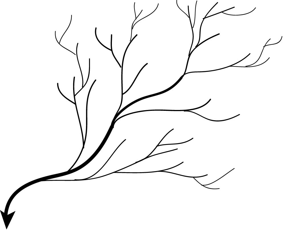
Classic test matches: a volcano or dome → radial (Mount Rainier, Crater Lake's rim); a crater, caldera or closed desert basin → centripetal (inward); an eroded dome with alternating hard and soft rings, such as the Black Hills of South Dakota → annular; folded mountains such as the Valley and Ridge of the Appalachians → trellis; jointed or faulted bedrock (often igneous or metamorphic) → rectangular; flat-lying, uniform rock → dendritic, the most common pattern; a steep, uniform slope or newly emerged coastal plain → parallel.
Concordant drainage follows the geologic structure (trellis streams in folded rock). Discordant drainage cuts across it, and comes in two kinds:
- An antecedent stream existed before the mountains rose and cut down as fast as they were uplifted, so it now crosses the range in a gorge (rivers that cross the Himalaya, such as the Arun, are classic examples).
- A superposed (superimposed) stream developed on younger cover rocks and kept its course as it cut down into older, differently structured rocks below.
Streams are also named by their relation to the original slope: consequent streams follow the original slope of the land, subsequent streams develop later along belts of weak rock, obsequent streams flow opposite to the original slope, and resequent streams flow in the same direction as consequent ones but at a lower level.
Drainage density and texture
Drainage density measures how closely the channels are spaced.
Drainage texture describes the same property qualitatively. A fine texture means many closely spaced channels, as in badlands on soft, impermeable clay with little vegetation. A coarse texture means widely spaced channels, as on permeable sandstone or limestone where most water infiltrates instead of running off.
Fluvial sediment and channel form
Sediment properties
Grain size follows the Udden-Wentworth scale: clay is finer than 1/256 mm, silt runs from 1/256 to 1/16 mm, sand from 1/16 to 2 mm, and gravel is coarser (granules, pebbles, cobbles above 64 mm, boulders above 256 mm). Sorting describes how similar the sizes are: river sand is moderately to well sorted, debris-flow and glacial deposits poorly sorted. Rounding (how worn the corners are) increases with transport distance. Shape depends partly on the source rock; slate gives flat pebbles however far it travels. Well sorted and well rounded means long transport; angular and poorly sorted means a nearby source.
| Class | Size (mm) | φ (phi) | Rock when lithified |
|---|---|---|---|
| Boulder | Above 256 | Below −8 | Conglomerate (rounded) or breccia (angular) |
| Cobble | 64–256 | −6 to −8 | Conglomerate or breccia |
| Pebble | 4–64 (very coarse pebble 32–64) | −2 to −6 | Conglomerate or breccia |
| Granule | 2–4 | −1 to −2 | Conglomerate or breccia |
| Sand: very coarse, coarse, medium, fine, very fine | 1–2, 0.5–1, 0.25–0.5, 0.125–0.25, 0.0625–0.125 | −1 to 4 | Sandstone |
| Silt | 1/256–1/16 (0.0039–0.0625) | 4 to 8 | Siltstone |
| Clay | Below 1/256 (0.0039) | Above 8 | Claystone, shale (mudstone if blocky) |
The phi scale turns sizes into whole numbers: (d in mm), so each class boundary is a doubling, and larger φ means finer grains. Sandstone, siltstone and shale are clastic (detrital) sedimentary rocks, built from fragments of older rock. Chemical sediments precipitate from solution (rock salt, gypsum, some limestone, travertine); travertine forms where CO₂-rich hot or cold springs that have dissolved limestone at depth degas at the surface, as at Mammoth Hot Springs in Yellowstone, so travertine deposits usually imply limestone below. Tufa is a softer, porous spring or lake carbonate. Organic (biochemical) sediments come from living things (coal from plants, shell limestone, chalk). A salt flat is dominated by chemical rather than detrital sediment.
Mixtures are named by their two main components, with the larger one as the noun: mostly sand with a lot of silt is a silty sand; mostly silt with some sand is a sandy silt (Shepard's and Folk's triangle diagrams formalize this). Sorting and rounding together describe textural maturity. Water sorts grains by settling velocity, which depends on grain size first and also on density and shape; so a flow sorts sediment mainly by size (weight), and dense minerals such as gold and magnetite concentrate with larger light grains in placer deposits. Downstream along a river, grains get smaller, rounder and better sorted, so coarse sediment drops out upstream and finer sediment travels farther downstream. On the Hjulström diagram, sand already moving keeps moving down to very low speeds: the deposition (settling) curve for sand of about 0.1–2 mm lies at roughly 1–20 cm/s, so a 1 mm grain stays in motion down to about 10 cm/s (it needs about 20 cm/s to be picked up from rest), and a 2 mm grain settles below roughly 15–20 cm/s. Grains are worn by attrition (knocking against each other, which makes them smaller and rounder) and abrasion (grinding against the bed).
| Environment | Typical texture |
|---|---|
| Glacial till | Unsorted, angular, all sizes from clay to boulders, striated clasts |
| Alluvial fan, debris flow | Poorly sorted, angular to subangular gravel and sand |
| River channel | Moderately sorted, rounded gravel and sand, cross-bedded, fining upward |
| Floodplain | Fine silt and clay, mud cracks, roots |
| Delta | Sand at the front grading to mud offshore |
| Beach | Well sorted, well rounded sand (or pebbles) |
| Wind (dunes) | Very well sorted, well rounded, frosted fine to medium sand, large cross-beds |
| Lake bottom | Fine laminated mud, varves in glacial lakes |
Load, competence and capacity
A river carries sediment in three ways:
- Bed load rolls, slides or saltates (bounces in short hops) along the bottom. Sand and gravel travel this way.
- Suspended load is held up in the water by turbulence. Fine silt and clay in suspension are what make a river look muddy.
- Dissolved load is ions in solution. It is invisible and comes mostly from chemical weathering and groundwater inflow.
The finest part of the suspended load (clay and fine silt that almost never settles in the channel) is called wash load. In most large rivers the suspended load is the biggest share of the total; the dissolved load is largest where water flows mostly through soluble rock, and bed load matters most in steep, gravelly mountain streams and braided rivers. Fertilizer nutrients (nitrate, phosphate, potassium), road salt and the ions from weathering (calcium, bicarbonate, sodium, chloride) travel as dissolved load. The suspended load causes most turbidity. The total dissolved load generally increases downstream as tributaries and groundwater add water and solutes, although its concentration can rise or fall depending on the rocks crossed and on dilution by rain.
Competence is the largest grain a stream can move. A common textbook rule says the largest movable particle mass scales with about the sixth power of velocity, so doubling speed moves particles roughly 64 times heavier. Capacity is the total load a stream can carry, and it rises with discharge. Sediment supply is what the basin delivers; landslides, bare fields and construction raise it, forests and dams lower it. Supply above capacity means deposition and bars; supply below capacity means bed and bank erosion.
| Change | Competence | Capacity |
|---|---|---|
| Flood (more discharge and velocity) | Up | Up |
| Steeper gradient | Up (gradient and competence are directly related) | Up |
| Gentler gradient, entering a lake or the sea | Down: deposition, deltas and fans | Down |
| Dam (velocity near zero in the reservoir) | Near zero: sediment trapped upstream | Near zero |
| Narrow, fast mountain stream | High: moves boulders | Low: small volume of water |
| Wide, deep lowland river | Low: only sand and mud | High: huge total load |
Competence depends mainly on velocity; capacity depends mainly on discharge (and so on velocity and channel size together). A small, fast stream can have high competence but low capacity; a big, slow river the reverse. Capacity always increases with velocity if everything else stays the same. Capacity scales with stream power, the rate at which the falling water releases energy (ρgQS, explained under Discharge), so it rises steeply with both discharge and slope.
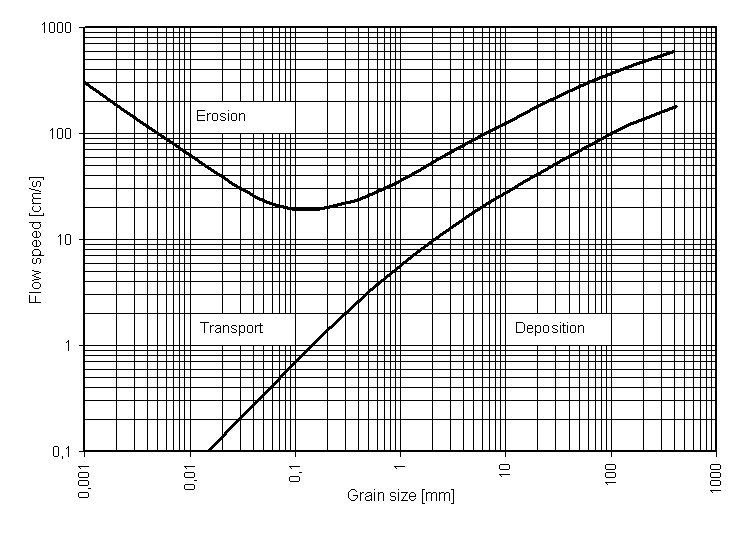
Large grains settle faster than small ones. For fine particles in still water (the Stokes regime) settling speed grows with the square of the diameter, because small grains have more surface area, and so more drag, per unit of mass.
Irregular grains are described by their nominal diameter, the diameter of a sphere with the same volume: d_n = (6V/π)^(1/3); a 5 mm³ grain has d_n = (30/π)^(1/3) = 2.12 mm. Doubling the diameter quadruples the settling speed.
Dense, spherical grains settle fastest; flat (platy) grains such as mica and clay flakes settle slowly and stay suspended. In cold water the higher viscosity slows settling. Tiny clay particles can clump into larger flocs (flocculation), especially when river water meets salty water in an estuary, and then settle much faster.
Entrainment is the lifting of a grain from the bed into the flow. These river transport and erosion terms are commonly matched:
| Term | Meaning |
|---|---|
| Traction | Large grains roll and slide along the bed |
| Saltation | Grains bounce along the bed in short hops |
| Suspension | Fine grains carried within the flow, held up by turbulence |
| Solution | Ions carried dissolved in the water |
| Hydraulic action | The force of moving water itself loosens and removes material |
| Abrasion (corrasion) | Carried sediment grinds the bed and banks; the main way rivers erode bedrock |
| Attrition | Carried particles collide and break into smaller, rounder pieces |
| Corrosion (solution) | Water chemically dissolves rock such as limestone |
Channel types and sinuosity
| Channel type | Look | Typical conditions |
|---|---|---|
| Straight | One channel, little bending | Short reaches, often guided by a fault or joint; rare over long distances |
| Meandering | One sinuous channel with point bars | Low gradient, fine cohesive banks, steady discharge, mostly suspended load |
| Braided | Many shallow strands around shifting bars | Steep gradient, abundant coarse bed load, erodible banks, highly variable discharge (glacial outwash, desert washes) |
| Anastomosing | Several deep, sinuous channels around stable vegetated islands | Very low gradient, fine sediment, cohesive banks, a rising base level |
The key difference between braided and anastomosing channels is stability. Braid bars shift with every flood, while anastomosing islands are vegetated and last for centuries.
Because the channel and the valley fall through the same height, sinuosity also equals valley slope ÷ channel slope (for example 0.0019 / 0.0012 = 1.58). Sinuosity can never be below 1, because no channel can be shorter than the straight line between its ends. Class boundaries differ between textbooks; a common scheme is about 1.0–1.05 straight, 1.05–1.3 sinuous (winding), 1.3–1.5 transitional, and above about 1.5 meandering; some tests call anything above about 1.25 meandering, so read the question's own definition if it gives one. Meandering stops short of infinite sinuosity because tight bends are cut off (neck and chute cutoffs) and form oxbows.
Channel anatomy. The thalweg is the line connecting the deepest points along a channel; it carries the fastest flow, swings to the outside of bends, and is often used as a political boundary. The riffle–pool sequence alternates shallow, fast, coarse-bedded riffles with deep, slow pools, spaced roughly five to seven channel widths apart, even in straight channels; meanders grow from this pattern. In a bend, water spirals in helical flow: surface water moves toward the outer bank and bottom water toward the inner bank, carrying sediment onto the point bar. Meander wavelength is usually about 10 to 14 channel widths.
| Feature | Straight | Meandering | Braided | Anastomosing |
|---|---|---|---|---|
| Gradient | Variable | Low | Relatively steep | Very low |
| Dominant load | Variable | Suspended and mixed; low bed load / total load | Bed load (coarse sand and gravel) | Suspended (fine) |
| Banks | Often bedrock or structurally controlled | Cohesive (silt and clay, vegetated) | Easily eroded, non-cohesive | Cohesive and vegetated |
| Discharge | Variable | Steady | Highly variable (snowmelt, glacial meltwater, flash floods) | Steady |
| Islands | None | None | Bare, shifting bars (eyots is an old name for small river islands) | Large, stable, vegetated islands |
| Typical setting | Short reaches, bedrock or fault-guided | Mature lowland floodplains | Glacial outwash, alluvial fans, desert washes | Inland deltas, wetlands, rising base level |
Anabranching is the general term for rivers that split into multiple channels separated by stable islands that last through floods; anastomosing rivers are the low-energy, fine-grained kind of anabranching river. They form when avulsions cut new channels across the floodplain while old ones stay active, when cutoffs isolate islands, and when vegetation colonizes and stabilizes mid-channel deposits. Straight channels are the rarest natural type over long distances. Braiding happens when the sediment supplied is more than the river can carry, so it drops bars and splits around them. Glacial streams are braided for all of these reasons at once: seasonal discharge, heavy sediment load, easily eroded banks and constantly shifting channels.

Bedforms
As flow over sand strengthens, the bed changes in order. Slow flow builds small ripples, faster flow larger dunes; both have a gentle upstream side and a steep downstream side and migrate downstream as sand avalanches down the steep face. Faster still, dunes wash out to a flat plane bed. Near a Froude number of 1 the surface forms standing waves and the bed forms antidunes, in phase with the waves and able to migrate upstream. Bars are larger sand or gravel deposits: point bars in bends, mid-channel bars in braided rivers.
| Flow regime | Bedforms, in order of increasing flow strength | Froude number |
|---|---|---|
| Lower flow regime | Plane bed with no motion → ripples (only in sand finer than about 0.6 mm; spacing under about 0.6 m) → dunes (sand waves) | Well below 1 |
| Transition | Washed-out dunes | Approaching 1 |
| Upper flow regime | Upper plane bed (fast flow, parallel laminations) → antidunes (in phase with standing surface waves; can migrate upstream) → chutes and pools | Approaching 1 and above (upper plane beds can form somewhat below 1) |
Fluvial landforms and valley processes
Long profile, gradient and base level
A longitudinal profile plots elevation against distance downstream. Most are concave-up, because discharge grows and sediment fines downstream, so the larger channel needs less slope to carry its load.
On a topographic map, gradient = contour interval × number of contour intervals between the two points ÷ channel distance between them (that is, the elevation difference ÷ channel distance). Cutting off a meander shortens the channel over the same drop, so the local gradient increases.
Base level is the lowest level a river can erode to: sea level ultimately, with lakes, reservoirs and resistant rock as local base levels. Lowering base level makes a river cut down; raising it causes deposition. The ultimate base level is the ocean; Lakes and ponds that a stream flows through act as temporary (local) base levels; a tributary's local base level is the river it joins (the Missouri's is the Mississippi). Building a dam creates a reservoir that raises the local base level upstream, so the river deposits sediment where it enters the reservoir. Global base level changes with sea level: ice ages lower it (rivers cut down), melting ice sheets and warming raise it.
Along its length a river is often divided into three zones (Schumm's model): a production (erosion) zone in the steep headwaters where sediment is generated, a transfer zone in the middle reaches, and a deposition zone in the lowlands, floodplain and delta. Geography texts call them the upper, middle and lower course.
| Upper course (headwaters) | Middle course | Lower course | |
|---|---|---|---|
| Gradient | Steep | Moderate | Gentle |
| Dominant process | Vertical erosion (downcutting) | Lateral erosion and transport | Deposition |
| Valley | Narrow, V-shaped | Wider, with a developing floodplain | Broad, flat floodplain |
| Channel | Narrow, shallow, rough, boulders | Wider and deeper; meanders begin | Wide, deep, smooth, high discharge |
| Landforms | Source (spring, lake, glacier or marsh where the river begins), waterfalls, rapids, gorges, potholes, interlocking spurs (ridges the winding young river flows between) | Meanders, river cliffs, point bars | Large meanders, oxbows, levees, deltas, estuaries |
| Load | Coarse, angular | Mixed | Fine, rounded |
Moving downstream, discharge, width, depth and mean velocity all increase, while gradient and grain size decrease. Mean velocity often increases downstream despite the gentler slope, because the bigger, smoother channel wastes less energy on friction; the tumbling headwater stream only looks faster.
Davis's cycle of erosion is an older model still asked about. A youthful river cuts down rapidly into a V-shaped valley with rapids and waterfalls and no floodplain. A mature river has graded its profile, erodes sideways, meanders and builds a floodplain about as wide as its meander belt. An old-age river wanders across a very broad, low floodplain much wider than its meander belt, with oxbows, levees and backswamps, on subdued topography. Modern geomorphology treats these "stages" as descriptions, not ages, but the vocabulary is common on tests.
Graded streams and dynamic equilibrium
A graded stream is not one where erosion and deposition stop; both continue, but they balance. It has adjusted its slope and channel shape so that, averaged over years, it carries exactly the load supplied to it, neither eroding nor depositing overall. A river in this kind of balance with its water and sediment is sometimes called a regime channel (regime theory). Along its course a river converts its potential energy into motion and heat; by the time it reaches base level that energy is spent, so it can no longer erode downward. A graded profile is a smooth, concave-up curve with no knickpoints; a stream that has not reached grade can have several knickpoints at once (one at each resistant layer or each past base-level drop). This is dynamic equilibrium: the river responds to any disturbance by changing in the direction that cancels it. For example, if base level drops, the river cuts down until a graded profile is restored. If supply increases, it deposits sediment and steepens until it can carry the extra load.
Lane's balance sums this up: sediment load × grain size ∝ discharge × slope (Q_s · D ∝ Q · S). If the left side grows (more or coarser sediment, as after logging) the river aggrades (builds up its bed); if the right side grows or sediment is cut off (as below a dam), it degrades (cuts down).
Erosional features and processes
Scour is the general term for erosion of a streambed and banks by flowing water, especially around piers and obstacles and during floods. Rivers erode by hydraulic action (moving water prying grains loose and forcing air into cracks), abrasion (carried grains grinding the bed) and solution. In uplands, downcutting outpaces widening and carves V-shaped valleys; lateral erosion by meandering widens valley floors.
A knickpoint is a sharp step in the profile, formed by a base-level drop, a fault or a resistant rock layer. Waterfalls are steep knickpoints that retreat upstream as weak rock under a resistant cap is undercut and the cap collapses, as at Niagara Falls. In stream capture (piracy), one stream erodes headward through a divide and steals a neighbor's headwaters. The clues are an elbow of capture (a sharp bend), a beheaded stream too small for its valley, and a dry notch in the ridge (a wind gap).
Knickpoints form wherever the profile is suddenly steepened: tectonic uplift, a drop in base level (sea-level fall), isostatic rebound after ice sheets melt, a river crossing from resistant to weak rock, or a dam being removed. Knickpoints are typical of bedrock channels; those made by a base-level drop migrate upstream as they erode, while one held by a resistant layer can stay anchored at that layer. When a dam is removed, the river cuts through the stored reservoir sediment and the new knickpoint travels upstream.
Headward erosion lengthens a valley at its upper end, often helped by groundwater sapping (springs undermining the valley head). Downcutting (vertical erosion) deepens the channel and dominates in steep uplands far above base level; once a river is close to base level, its energy turns sideways, widening the valley and building a floodplain. Where layers of different resistance alternate, as in the Grand Canyon (carved by the Colorado River), canyon walls form a stair-step profile: resistant sandstones and limestones make cliffs, and weak shales erode back into gentle slopes. In arid plateaus the same differential erosion leaves flat-topped mesas (wider than tall) and narrower buttes capped by resistant rock. Canyons and gorges form where rapid downcutting through resistant rock outpaces slope retreat, especially in arid climates, as in the Grand Canyon. River valleys in cross-section are V-shaped; glaciers carve U-shaped valleys with steep walls and flat floors, so "V-shaped valleys are made by glaciers" is false.
Waterfalls do not last: as the lip erodes and the fall retreats, the knickpoint becomes lower and less steep, eventually turning into rapids and then a smooth profile. A hanging valley forms where a main valley was deepened faster than its tributary (classically by a glacier, sometimes by a river cutting faster than a tributary on resistant rock), leaving the tributary's mouth high on the valley wall with a waterfall, as in Yosemite. Rejuvenation. When base level falls or the land rises, a river regains erosive power and cuts down again, leaving:
- Terraces: abandoned, flat floodplain remnants standing above the present floodplain. A fill terrace is the abandoned top of a thick valley fill of the river's own sediment, left when the river cut down into that fill; a strath (cut) terrace is a bedrock bench with a thin gravel cover. Paired terraces at the same height on both sides record rapid downcutting; unpaired ones record downcutting while the river swung sideways.
- Incised (entrenched) meanders: a meandering river cuts down into bedrock and keeps its loops, forming deep goosenecks (Goosenecks of the San Juan River, Utah; Horseshoe Bend on the Colorado River). An ingrown meander is asymmetric because it shifted sideways while cutting down.
- Knickpoints and waterfalls migrating up the profile.
Other ways drainage gets rerouted: retreating glaciers leave moraines and ice-scoured channels that send rivers on new courses (much of the Ohio and Missouri river systems took their present paths at ice margins), landslides and lava flows dam valleys, and karst collapse diverts streams underground. Faulting also redirects streams: a fault scarp can block or dam a stream, crushed rock along the fault zone erodes easily so streams follow it and erode headward along it (aiding capture), and tilting of fault blocks can reverse or divert drainage. Offset stream channels along strike-slip faults such as the San Andreas record the movement.
A water gap is a notch through a ridge that still carries a river; a wind gap is a dry notch abandoned after stream capture or uplift. Potholes are round holes drilled into bedrock by pebbles swirling in turbulent eddies (not in laminar flow); scour at an obstacle digs them just downstream of it.
Waterfalls form where a river crosses from resistant to weak rock, at faults, at hanging valleys left by glaciers, and at other knickpoints. The weak rock under the resistant cap is scoured out by the plunge pool, the cap is undercut and collapses, and the fall retreats upstream, leaving a gorge. Niagara Falls has receded about 11 km since the end of the last ice age, historically at roughly a meter a year; diverting water for hydropower and engineering works have slowed it greatly; estimates of today's rate range from about 30 cm (1 ft) a year to a few centimeters a year.
| Waterfall type | Description |
|---|---|
| Plunge | Falls vertically, losing contact with the rock face |
| Horsetail | Keeps contact with the rock face as it descends |
| Cascade | Descends a series of small rock steps |
| Tiered (staircase) | Several distinct drops, each with its own pool |
| Multi-step | A series of closely spaced falls of similar size, each with its own plunge pool |
| Block (sheet) | Falls from a wide stream, often as wide as it is tall |
| Cataract | A large, powerful waterfall |
| Fan | Spreads horizontally as it falls while touching the rock |
| Punchbowl | Squeezed through a narrow gap into a wide pool |
| Segmented | Splits into separate streams as it falls |
Waterfall records often asked: Angel Falls (Venezuela) is the tallest uninterrupted waterfall (about 979 m total, 807 m single drop); Victoria Falls (Zambezi River) is often called the largest single sheet of falling water by combined width and height; the largest by average flow are the Inga Falls and Boyoma Falls on the Congo River, which are rapids-like cataracts; Niagara Falls has the highest flow of North America's falls.
Meanders and floodplains
In a bend the fastest water swings outside and erodes a cut bank, while slower water inside deposits a point bar, so the bend migrates outward and downstream. When a narrow neck between bends is cut through, the abandoned loop becomes an oxbow lake.
The floodplain is the flat valley floor built from the river's own deposits. Floodwater overtopping the banks slows at once and drops its coarsest load beside the channel as natural levees; finer mud settles in backswamps. A river entering standing water builds a delta. A steep mountain stream reaching a flat valley loses confinement and gradient and drops its load as an alluvial fan, common in arid basins.
| Floodplain feature | How it forms |
|---|---|
| Alluvium | Any sediment deposited by a stream, in its channel, banks or floodplain |
| Cut bank (river cliff) | Steep outer bank of a bend, eroded by the fastest water |
| Point bar | Sandy deposit on the inner (convex) bank, where flow is slowest and friction greatest |
| Meander scar | Dry, curved trace of an abandoned bend, often beside oxbow lakes |
| Neck cutoff | The river erodes through the narrow neck between two bends during a flood |
| Chute cutoff | Floodwater cuts a shortcut across a point bar |
| Oxbow lake | The abandoned loop after a cutoff (called a billabong in Australia); it fills with sediment and becomes a marsh, then a meander scar |
| Natural levee | Low ridge of coarser sediment beside the channel, built when floodwater slows on leaving the channel |
| Backswamp | Poorly drained, low, muddy floodplain behind the levees |
| Yazoo tributary | A tributary blocked by the main river's levees, which flows parallel to it for a long way before joining (named after the Yazoo River, Mississippi) |
| Crevasse splay | Fan of sand spread onto the floodplain where a levee breaks |
| Avulsion | A sudden switch of the whole channel to a new course, often through a levee breach |
| Meander belt | The zone the meanders sweep across over time |

Meanders form in alluvial material on low gradients: a small bend makes faster water hit the outer bank, which erodes, while the inner bank gains a point bar, so the bend grows. Over time a meander passes through stages of growth, narrowing of the neck, cutoff, oxbow lake, and infilling. Ice jams tend to form at tight bends and constrictions, flooding the land upstream of the jam first.
Avulsion in practice. The Mississippi has shifted its lower course several times in the last 7,000 years, building successive delta lobes. Today it is "trying" to switch into the shorter, steeper Atchafalaya River, a capture that the U.S. Army Corps of Engineers' Old River Control Structure has prevented since the 1960s. Political boundaries drawn along a river's old course stay fixed while the river moves, which is why some state and county borders no longer follow the channel.
Deltas and alluvial fans
The landform is named for the Greek letter Δ, because the Nile delta is roughly triangular. A delta forms where a river enters standing water, slows, and drops its load faster than waves and tides remove it. Its main channel splits into distributaries. In a simple (Gilbert-type) delta, coarse sediment builds steep, inclined foreset beds at the advancing front, fine mud settles farther out as flat bottomset beds, and the river spreads thin, flat topset beds of channel gravel and sand over the top. Grain size: topset (river-channel gravel and sand, with finer overbank mud) and foreset (sand and gravel avalanching down the front) are both coarse, and bottomset is finest (silt and clay). A delta is divided into the delta plain (on land), the delta front, and the prodelta offshore.
| Delta type | Dominant force | Shape | Example |
|---|---|---|---|
| Bird's-foot (river-dominated) | River sediment overwhelms weak waves and tides | Long fingers of distributaries with levees | Mississippi |
| Arcuate (fan-shaped) | Mixed river and waves | Smooth curved front, many distributaries | Nile, Niger |
| Cuspate | Strong waves | Pointed, tooth-like shape with sandy beaches on both sides | Tiber (Italy), São Francisco (Brazil) |
| Tide-dominated (estuarine) | Strong tides | Sand bars and islands elongated along tidal currents; a drowned estuary partly filled with sediment | Ganges–Brahmaputra, Fly (Papua New Guinea) |
| Inland delta | River entering a basin on land | Spreading channels that end in swamps and evaporation | Okavango (Botswana) |

Deltas are also described by setting and history: a lacustrine delta builds into a lake (many Gilbert-type deltas), an estuarine delta fills a drowned river mouth, an abandoned delta lobe stops growing after the river switches course (avulsion) and begins to subside and erode, and a truncated delta has been cut back by waves or currents.
Fans come in types: alluvial fans built by streams and sheetfloods (broad, shallow sheets of water that spread over the fan surface during flash floods), debris-flow fans built mainly by debris flows, colluvial fans built by slope wash and mass wasting with little channelized flow, and very large, gently sloping fluvial fans (megafans) built by big rivers leaving mountain fronts. Whether a delta grows or shrinks depends on sediment supply against relative sea-level change: plenty of sediment and stable or falling relative sea level (regional uplift) build it seaward, while dams that trap sediment, less precipitation and runoff, and subsidence or rising sea level make it retreat, as in Louisiana today. Deltas and alluvial fans form for the same reason, a sudden loss of gradient and confinement, so they share a location of deposition (where a channel meets a flat basin) and both have distributaries, but fans form on land, are steeper and coarser, and are typical of arid mountain fronts, while deltas form in water. Debris flows and lahars (volcanic mudflows) also build fans.
An estuary is the transition zone where a river meets the ocean, usually a drowned river mouth, where fresh water mixes with seawater, making brackish water. By origin they are coastal-plain (drowned river valleys, such as Chesapeake Bay), fjords (drowned glacial troughs, often strongly stratified), bar-built (behind barrier islands or spits) and tectonic (San Francisco Bay).
Streamflow and floods
Flow regimes
A perennial stream flows all year because groundwater keeps feeding it (baseflow). An intermittent stream flows for part of the year, when the water table rises above the bed in the wet season. An ephemeral stream flows only during and just after rain or snowmelt, because its bed is always above the water table.
A stream gains water where the water table slopes toward the channel and loses water where the channel sits above the water table. Humid-region streams are mostly gaining, arid-region streams mostly losing.
| Term | Meaning |
|---|---|
| Gaining (effluent) stream | Groundwater flows into the channel; water table above the stream surface; discharge grows downstream; on a water-table map, contours bend into V's pointing upstream where they cross the stream |
| Losing (influent) stream | Water leaks out through the bed; water table below the stream surface; contours bend into V's pointing downstream |
| Disconnected losing stream | The water table is so deep that an unsaturated zone separates it from the bed; typical of desert washes and ephemeral streams |
| Flow-through stream | Gains on one bank and loses on the other |
| Baseflow | The groundwater contribution that keeps a stream flowing between storms (dry-weather flow) |
| Interflow | Water that moves sideways through the unsaturated soil into the channel |
| Bank storage | During a flood the stream rises above the water table and pushes water into its banks; it drains back slowly as the flood recedes |
| Hyporheic zone | The saturated gravel under and beside the channel where stream water and groundwater mix; flow through it is why a pool can measure more discharge than the riffle just upstream |
A stream can switch. A gaining stream turns losing for a while during a flood (bank storage) or permanently when nearby pumping lowers the water table below it (the well "induces recharge" from the stream). An intermittent stream gains in the wet season and dries in the dry season. "Ephemeral" and "intermittent" streams are both temporary streams; desert ephemeral channels are called arroyos, washes or wadis.
Discharge, velocity and load
Discharge is the volume of water passing a cross-section per second.
Velocity is fastest just below the surface mid-channel and slowest along the bed and banks, where friction acts. In a flood, discharge, velocity and depth rise together, so competence and capacity soar and most of a year's sediment can move in days. Sediment discharge (such as tonnes per day) is concentration times water discharge.
What controls stream velocity: gradient (steeper → faster); discharge (more water → faster); channel shape (a deep, semicircular channel with a large hydraulic radius loses less to friction than a wide, shallow one); and roughness of the bed and banks (boulders, vegetation, bends slow it). Water chemistry such as pH does not matter. A stream's energy budget explains why: almost all of the energy the falling water releases is lost to friction and turbulence as heat, and only a small fraction goes into eroding and carrying sediment, which is why small changes in roughness or slope change velocity and erosion so much.
Going from the surface down to the bed, velocity therefore decreases (apart from a slight dip right at the surface from air drag). The maximum is not always in the exact center: in a bend it shifts toward the outer, deeper side, along the thalweg. A higher stage usually means higher velocity as well as more area.
Units. The SI unit of discharge is m³/s (cumecs); U.S. gauges report ft³/s (cfs). 1 m³/s = 35.3 ft³/s. Watch for area units: width × depth gives m² or ft², never ft.
Open-channel flow has a free surface open to the atmosphere (rivers, canals, partly full pipes) and is driven by gravity down the slope; closed-conduit (pipe) flow fills a pipe and is driven by pressure, so a river is an open channel. Laminar and turbulent flow. In laminar flow, water moves in smooth, parallel layers along definite paths with little mixing; it occurs only in very slow, shallow or very viscous flow, and in most groundwater. In turbulent flow, eddies and swirls mix the water in all directions; almost all streams and rivers are turbulent, and turbulence is what keeps sediment suspended. Turbulence grows with velocity, depth and bed roughness and falls with viscosity (cold water is more viscous). The Reynolds number measures it.
Fast flow in a deep channel is the most likely to be turbulent. Most fluids, water included, become less viscous as temperature rises.
Open-channel flow equations
The rules do not name specific equations; the standard ones are Manning's and Chezy's, plus the Froude number above.
Hydraulic radius R = A / P, where P is the wetted perimeter, the length of channel boundary in contact with water (the bed and banks, not the free surface). A larger R means less of the flow touches the boundary, so less friction and a faster flow for the same slope. For a very wide, shallow channel, R ≈ mean depth.
| Cross-section (flowing full) | Area A | Wetted perimeter P | Hydraulic radius R |
|---|---|---|---|
| Rectangle, width w, depth d | w·d | w + 2d | w·d / (w + 2d) |
| Semicircle, radius r | πr²/2 | πr | r/2 |
| Full circular pipe, radius r | πr² | 2πr | r/2 |
| Very wide channel, depth d | — | — | ≈ d |
So a semicircular river 10 m wide (r = 5 m) has R = 2.5 m, and a rectangular creek 15 ft wide and 3 ft deep has P = 15 + 2(3) = 21 ft, A = 45 ft² and R = 2.14 ft.
In U.S. customary units Manning's equation carries a conversion constant: with v in ft/s and R in ft.
| Surface | Typical Manning's n |
|---|---|
| Smooth concrete, plastic pipe | About 0.011–0.013 |
| Clean, straight earth or gravel channel | About 0.022–0.030 |
| Natural stream, clean and winding, some pools | About 0.033–0.045 |
| Mountain stream with cobbles and boulders | About 0.04–0.07 |
| Weedy reaches, brushy floodplains | About 0.05–0.15 |
Roughness usually decreases downstream as beds become finer and channels smoother. Manning's equation is generally considered more accurate and is more widely used than Chezy's. In Chezy's equation, C is the friction (roughness) factor; it has units of m^(1/2)/s, although tests sometimes treat it as unitless.
Flood frequency and recurrence intervals
Ranking each year's largest flood gives a recurrence interval, the average years between floods that size or larger.
Plotting discharge against recurrence interval on log paper gives a flood-frequency curve, from which you read the expected 50- or 100-year flood. Short records make its extreme end uncertain, and urbanization or dams shift it.
The ranking formula T = (n + 1)/m is the Weibull plotting position. Rank 1 is always the biggest flood. Peak discharge rises roughly with the logarithm of the recurrence interval, which is why the curve is plotted on a log axis and straightens out there. Because of that, you cannot scale stages or discharges linearly between recurrence intervals: a 100-year flood is not "half" of a 200-year flood. Bankfull discharge in many alluvial rivers has a recurrence interval of about 1.5 years.
A flow-duration curve plots discharge against the percentage of time it is equaled or exceeded (for example, Q₉₀ is a low flow exceeded 90% of the time); a flat curve means a steady, groundwater-fed stream and a steep one a flashy stream. For official flood estimates the USGS fits annual peaks with the Log-Pearson Type III distribution (Bulletin 17C) rather than simple ranking.
Types of floods. Riverine (fluvial) floods come from prolonged rain or snowmelt over a basin and rise over days. Flash floods rise within about six hours of intense rain, a dam failure or an ice-jam release, typically in steep or arid terrain; they kill the most people, often in vehicles (the U.S. National Weather Service warns that about 15 cm (6 in) of moving water can knock a person down and about 30 cm (1 ft) can sweep a vehicle away). Areal (pluvial or urban) floods occur where rain cannot drain from flat or paved ground. Coastal floods come from storm surge and high tides. Ice-jam floods back water up behind ice blocks. Glacial outburst floods (jökulhlaups) release ice-dammed lakes. In Iceland they are often triggered by volcanic eruptions melting ice beneath a glacier. The 1976 Big Thompson Canyon flash flood in Colorado killed 144 people after a stalled thunderstorm dropped about 300 mm of rain in a few hours.
Flood stage is the stage at which a river overflows its banks enough to threaten people and property. The 100-year floodplain (the "base flood" area on FEMA flood-insurance maps) has a 1% annual chance of flooding. Flood control is structural (direct: dams, levees, floodwalls, channel improvements, diversion channels) or nonstructural (indirect: floodplain zoning, building codes, insurance, warning systems, buyouts, and restoring wetlands and floodplains that store water). Spillways do not cause floods; they protect dams from overtopping.
Groundwater and karst
Subsurface zones and capillarity
The zone of aeration (vadose zone) holds air and water in its pores; below it every pore in the zone of saturation is full. Their boundary is the water table, where water pressure equals atmospheric pressure. Capillarity (surface tension plus attraction to grain surfaces) draws water up into a capillary fringe above it, higher in finer pores: centimeters in coarse sand, a meter or more in silt and clay. A perched water table sits on a clay lens above the main one.
From the surface down, the subsurface reads: soil-water zone (root zone) → intermediate vadose zone → capillary fringe → water table → saturated zone (phreatic zone). The vadose zone is not dry: its pores hold both air and water. Only water in the saturated zone is called groundwater, and the saturated zone holds most of the world's liquid fresh water. Most groundwater is meteoric (it fell as precipitation and infiltrated); connate water was trapped in a rock's pores when the sediment was deposited, and is usually salty and old; juvenile water comes from magma. In the vadose zone, water clings to grains as films and as rings at grain contacts (pendular water) held by surface tension. The capillary fringe lies just above the water table, at the base of the unsaturated zone; its lowest part is almost saturated, held by tension.
The water table is a subdued copy of the land surface: higher under hills, lower under valleys, and it meets the surface at springs, gaining streams, lakes and wetlands. It rises after precipitation and infiltration (and with snowmelt or irrigation return flow) and falls during droughts, hot seasons of high evapotranspiration, and pumping, so it changes with the seasons. Its depth depends on climate (rainfall), topography and the permeability of the ground, but not on pollution. To measure the thickness of the vadose zone at a site, measure the depth to water in a well. Deep tree roots grow down to the saturated zone to survive droughts. Soil is waterlogged when the water table (or the capillary fringe above it) rises into the root zone, so the pores stay filled with water rather than air and roots are starved of oxygen.
A perched aquifer forms above the main water table where a laterally limited aquitard (a clay or shale lens) stops downward percolation, typically in hilly terrain. If a perched water table meets a hillside or valley wall, the water emerges as a spring or seep. A shallow water table found unexpectedly in an otherwise deep-water area is often perched.
Capillary rise is higher in finer material. A well-sorted fine silt has more capillarity than a well-sorted coarse sand, even though the sand drains faster.
Aquifers, porosity and permeability
Porosity is the fraction of a material's volume that is open space, so it measures how much water the material holds. Permeability (for water, hydraulic conductivity K) measures how easily water moves through the connected pores. Clay has very high porosity but tiny, poorly connected pores, so it is nearly impermeable. Sand and gravel have lower porosity but high permeability. An aquifer stores and transmits useful amounts of water. An aquitard or aquiclude slows or blocks flow.
| Aquifer type | Setting | Water level in a well |
|---|---|---|
| Unconfined | Open to recharge from above; top is the water table | Stands at the water table |
| Confined | Sandwiched between aquitards; water under pressure | Rises above the top of the aquifer, to the potentiometric surface |
| Artesian (flowing) | Confined aquifer whose potentiometric surface is above the land | Flows out without pumping |
| Perched | Small saturated lens above the main water table, resting on an aquitard | Stands at the perched water table; may go dry when pumped |
| Leaky (semiconfined) | Confined by an aquitard that lets some water seep through | Between unconfined and confined behavior; pumping draws extra water through the leaky layer |

A water-table well taps an unconfined aquifer and rises and falls with the water table. An artesian well taps a confined aquifer, and its water rises above the top of the aquifer under pressure; a flowing artesian well rises above the land surface, so it needs no pump at all. For artesian pressure the aquifer must be confined above and below by aquitards and its recharge area must be higher than the well; a confined aquifer is recharged only where it is exposed at the surface (its outcrop) or by slow leakage through the confining layers, often far from the well, as in the Dakota Sandstone or Australia's Great Artesian Basin. Where a confined aquifer's head is above the water table, a well screened in it shows a water level shallower than the local water table, because a fine-grained confining unit holds the pressure in. Confined aquifers can feed springs along faults or where the confining layer is breached.
An aquifer is not an underground lake or river: almost all groundwater fills tiny pores and cracks in rock and sediment; open caves with flowing water occur mainly in karst (and locally in lava tubes). Porosity n = volume of voids ÷ total volume, a fraction from 0 to 1 (or a percentage). Primary porosity forms with the rock (spaces between grains); secondary porosity forms later (fractures, dissolution cavities, as in karst). Effective porosity counts only the connected pores that can carry flow; it is the porosity used in the seepage velocity formula.
| Material | Typical porosity | Relative permeability | As an aquifer |
|---|---|---|---|
| Unconsolidated gravel | 25–40% | Very high | Excellent |
| Unconsolidated sand (well sorted) | 25–50% | High | Excellent |
| Mixed sand and gravel (poorly sorted) | 20–35% | Moderate–high | Good |
| Silt, loess | 35–50% | Low | Poor |
| Clay | 40–70% | Very low | Aquitard or aquiclude |
| Glacial till | 10–35% | Very low | Aquitard |
| Sandstone | 5–30% (lower when well cemented) | Moderate | Good, especially if poorly cemented |
| Conglomerate | 5–25% | Moderate | Fair to good |
| Limestone, dolomite (karstic) | Below 10% in solid rock; up to 50% in heavily dissolved rock | Low in solid rock; very high in karst conduits | Excellent but easily polluted |
| Shale | 0–10% | Very low | Aquitard |
| Fractured granite or basalt | 0–10% (basalt with lava tubes and vesicles higher) | Moderate along fractures | Fair |
| Unfractured granite, gneiss | Below 5% | Near zero | Aquifuge |
Porosity of ideal spheres depends only on packing, not on size: cubic packing (each sphere stacked directly above another) gives 1 − π/6 = 47.6%, and the tightest rhombohedral packing gives about 26%. Real sand, with mixed sizes and shapes, lies between. Note that aquitards are defined by low permeability, not low porosity: a clay aquitard has very high porosity, while a shale aquitard has low porosity.
Values are typical ranges from standard hydrogeology texts; well-sorted, rounded, uncemented grains give the highest porosity, while poor sorting (small grains filling the gaps) and cement lower it. Porosity does not depend on grain size for ideally packed spheres of one size, but in real sediments finer materials have higher porosity because clay grains are platy and loosely packed. Permeability, by contrast, rises strongly with grain size. Sandstones are classified by grain type and matrix: an arenite has less than about 15% fine mud matrix (clean, porous and permeable), a wacke (graywacke) more than about 15% (poorly sorted, poor aquifer); a quartz arenite is nearly all quartz, an arkose is rich in feldspar (over about 25%), and a lithic sandstone is rich in rock fragments. Sandstone and gravel are the classic aquifers; shale and clay the classic confining layers. Note on shale: compacted shale has low porosity (about 0–10%) in hydrogeology tables, but because it forms from clay, many introductory texts describe it as high porosity, low permeability; if a question pairs shale with "high porosity but low permeability", that is the intended answer. A rock with lots of water that a well cannot easily extract has low permeability.
| Term | Meaning |
|---|---|
| Aquifer | Rock or sediment that stores and transmits useful amounts of water to wells and springs |
| Aquitard | Low-permeability layer that slows but does not stop flow (sandy clay, silt) |
| Aquiclude | Almost impermeable layer that stores water but transmits almost none (clay) |
| Aquifuge | Neither stores nor transmits water: low porosity and low permeability (unfractured granite) |
| Confining bed | Any aquitard or aquiclude bounding a confined aquifer; low hydraulic conductivity |
Specific yield (S_y) is the fraction of the total volume that drains out by gravity; specific retention (S_r) is the fraction held back on grain surfaces by surface tension. Together they make up the porosity: n = S_y + S_r. Clay has high porosity but very low specific yield (it holds its water); sand and gravel give up most of theirs (S_y roughly 0.2–0.3).
Hydraulic head and Darcy's law
Groundwater flows from high hydraulic head to low head. Head is the sum of elevation head (height above a datum) and pressure head (the height of the water column the pressure would support). The hydraulic gradient is the change in head divided by the distance between the points.
Hydraulic head, more carefully. Head is mechanical energy per unit weight of water, expressed as a height: h = z + p/(ρg) (+ v²/2g, the velocity head, which is negligible in groundwater). The elevation head z is the height above a datum (usually sea level); the pressure head p/(ρg) is how high the pressure would push water up a tube. Multiplying head by g gives hydraulic potential (energy per unit mass); multiplying by ρg gives energy per unit volume, E = ρgh, so h = E/(ρg). A piezometer is a tube open only at its bottom, so its water level shows the head at that one point. Groundwater flows from high head to low head, not necessarily downhill or from high pressure to low; upward flow is common in discharge areas. Pressure converts to head with 1 psi = 2.31 ft of water and 1 atm ≈ 10.3 m of water, so 70 psi ≈ 162 ft of head.
Darcy's law was found by the French engineer Henry Darcy in 1856 while designing sand filters for the fountains of Dijon. In differential form, q = −K dh/dl: the minus sign says flow goes down the head gradient. Q = KiA is the volumetric discharge; q = Q/A = Ki is the Darcy flux (specific discharge), a fictitious velocity as if water used the whole cross-section; the real average seepage (linear) velocity is v = Ki/n_e, faster because water moves only through the pores. Darcy flux 5.2 m/min with effective porosity 0.41 gives seepage velocity 5.2/0.41 = 12.7 m/min.
When Darcy's law works. It assumes slow, laminar flow through a porous medium (Reynolds number below about 1 to 10, based on grain size), steady conditions, and a fully saturated medium. It applies to granular sediments and, approximately, to fractured rock at large scales. It breaks down for turbulent flow: in karst conduits, wide fractures, coarse gravel at high gradients, and right at the screen of a pumping well where velocities are high. For very short time scales, where storage changes, a time-dependent storage term is added (the groundwater flow equation).
Permeability versus hydraulic conductivity. Intrinsic permeability k (m², or darcys) belongs to the rock alone (pore size and connectivity). Hydraulic conductivity K (m/s) includes the fluid: K = kρg/μ. The same sand has a higher K for warm water (lower viscosity) than for cold water, and a much lower K for oil.
| Material | Typical K (m/s) |
|---|---|
| Clean gravel | 10⁻³ to 10⁻¹ |
| Clean sand | 10⁻⁵ to 10⁻³ |
| Silty sand, fine sand | 10⁻⁷ to 10⁻⁵ |
| Silt, loess | 10⁻⁹ to 10⁻⁵ |
| Glacial till | 10⁻¹² to 10⁻⁶ |
| Unweathered clay | 10⁻¹³ to 10⁻⁹ |
| Karst limestone | 10⁻⁶ to 10⁻² |
| Sandstone | 10⁻¹⁰ to 10⁻⁶ |
| Peat | 10⁻⁹ to 10⁻³ (highest in fresh surface peat; falls as peat decomposes and compacts) |
| Unfractured igneous and metamorphic rock | 10⁻¹⁴ to 10⁻¹⁰ |
These are order-of-magnitude ranges; K spans more than ten orders of magnitude across natural materials, more than almost any other physical property. U.S. sources often give K in ft/day: 1 m/s = 2.83 × 10⁵ ft/day and 1 m/day = 3.28 ft/day, so clean sand (10⁻⁵ to 10⁻³ m/s) is about 3 to 300 ft/day and clean gravel can exceed 1,000 ft/day.
An aquifer is homogeneous if K is the same everywhere and heterogeneous if it varies from place to place; it is isotropic if K is the same in every direction and anisotropic if water flows more easily in one direction than another. Layered sediments are typically anisotropic, with horizontal K much greater than vertical K. Hawaii's highly productive aquifers are in fractured, porous basalt lava flows, with freshwater lenses floating on seawater. Fracturing a rock adds secondary porosity and increases its permeability. Pore water exists to depths of several kilometers (deep boreholes find it), but porosity and permeability decline with depth as overburden compacts and cements the rock and water gets saltier, so most usable fresh groundwater lies within the upper few hundred meters.
Measuring K. In the lab, a permeameter pushes water through a sample. A constant-head permeameter gives K = QL/(AΔh) directly from Darcy's law; a falling-head permeameter (for low-K samples) gives K = (aL/(At)) ln(h₁/h₂), where a is the standpipe area. In the field, pumping (aquifer) tests watch drawdown in observation wells around a pumped well, and slug tests add or remove a quick volume ("slug") from one well and time the recovery (Hvorslev's method). K can also be estimated from grain size with empirical formulas such as Hazen's (K in cm/s ≈ 1 × (d₁₀ in mm)², where d₁₀ is the size that 10% of the sample is finer than), Kozeny–Carman or Beyer.
Flow nets. In a uniform (homogeneous, isotropic) aquifer, flow lines cross equipotential lines (contours of equal head) at right angles, forming a grid of curvilinear squares. Closely spaced equipotentials mean a steep gradient and faster flow. Where flow crosses a boundary between materials, flow lines bend (refract) according to the tangent law, K₁/K₂ = tan θ₁ / tan θ₂ (angles measured from the normal to the boundary): flow lines bend toward the normal in the low-K layer, so water crosses aquitards nearly vertically and travels along aquifers nearly horizontally.
Recharge and discharge
Recharge reaches the saturated zone from infiltration and losing streams; the water table rises when recharge exceeds discharge. Groundwater discharges at springs, gaining streams, wetlands, lakes and wells. A spring forms where the water table meets the surface or an impermeable layer forces water out on a hillside. Flow paths curve from recharge to discharge areas, and the deepest paths carry the oldest water.
Natural discharge also includes transpiration by phreatophytes and evaporation where the water table is shallow; percolation into an aquifer is recharge, not discharge. If recharge to a confined aquifer is less than withdrawals, the aquifer stays saturated but its pressure (head) falls. Recharge areas are where contaminants can enter an aquifer most easily, so they are protected. Artificial recharge puts surface water back underground through spreading basins, recharge (injection) wells, or aquifer storage and recovery (ASR) wells; a river can be diverted to a recharge basin, or treated water imported and injected.
Springs form in several settings:
| Spring type | Setting |
|---|---|
| Depression spring | The land surface dips below the water table, as in a valley bottom |
| Contact spring | A permeable layer sits on an impermeable one, and water flows out along the contact on a hillside (including perched water tables) |
| Fault or fracture spring | Water rises along a fault or fracture zone, often from a confined aquifer |
| Artesian spring | Confined water escapes upward where the confining layer is breached |
| Karst (tubular) spring | A cave conduit reaches the surface; can discharge huge volumes (a Vauclusian spring rises from a deep, flooded shaft) |
| Thermal (hot) spring | Groundwater heated by deep circulation or near magma |
| Geyser | A hot spring with a constricted plumbing system: water at depth is superheated above 100 °C under pressure, a little flashes to steam, pressure drops, and the column erupts (Old Faithful, Yellowstone) |
| Seep | Slow, diffuse discharge without a single outlet |
A spring needs the water table (or a potentiometric surface) to actually cut the land surface; where the ground is only tangent to the water table, no flowing spring forms.
Major aquifers of the world include the High Plains (Ogallala) aquifer (U.S. Great Plains), the Floridan aquifer (karst limestone, Florida and neighbors), the Edwards aquifer (Texas karst), the Central Valley aquifer system (California), the Guarani aquifer (Brazil, Argentina, Paraguay, Uruguay; one of the largest), the Great Artesian Basin (Australia; the largest artesian basin), the Nubian Sandstone aquifer (Egypt, Libya, Sudan, Chad; fossil water) and the North China Plain aquifer. In permafrost regions, supra-permafrost water sits in the thawed active layer above the frozen ground (perched on it), intra-permafrost water in taliks, and sub-permafrost water lies below the permafrost, which acts as a confining layer.
Wells. Wells are dug (wide, shallow, hand-dug, easily contaminated), driven (a pipe with a screened point hammered into shallow sand), or drilled (rotary or cable-tool rigs, the only kind that reaches deep or rock aquifers; deep "consolidated" rock wells are often hundreds of feet deep). A modern drilled well has a casing (pipe that keeps the hole open and sealed), a screen (slotted section that lets water in but keeps sand out) surrounded by a gravel (filter) pack, a grout seal (cement or bentonite clay) filling the annular space around the casing to stop surface water and contaminants from running down the outside, and a sanitary cap. A wellhead protection area is the zone around a public supply well where land uses are controlled to keep contaminants away. An observation well is usually screened over a long interval and shows the water table; a piezometer is open only over a short interval at its base and measures the head (pressure) at that depth. Dewatering is pumping to lower the water table for mines and construction pits. Deep-well injection pumps liquid wastes or brines into deep, isolated rock layers; injected waste can stay there for a very long time, but it can also leak into usable aquifers or, at high rates, trigger earthquakes.
| Well type | How made | Depth | Pros | Cons |
|---|---|---|---|---|
| Dug | Excavated by hand or machine, lined with stone or concrete | Shallow, usually under about 10 m | Cheap, simple, large storage | Easily contaminated by surface water; goes dry when the water table drops |
| Driven | Pipe with a screened point hammered into the ground | Shallow, usually under about 15 m, in sand and gravel only | Very cheap, quick to install | Small yield; cannot penetrate rock; contamination risk |
| Drilled (bored or rotary) | Drilled by a rig, cased and grouted | Tens to hundreds of meters, including rock | Reaches deep, protected aquifers; reliable, high yield | Expensive; needs a pump |
Cones of depression. Pumping lowers the head around a well into a cone of depression, circular in map view in a uniform aquifer, with the steepest slope (greatest gradient) near the well. The cone's slope and size depend on the pumping rate and the permeability (transmissivity): high K gives a wide, shallow cone, low K a steep, narrow one; higher pumping rates and longer pumping deepen and widen it. Where two cones overlap, wells interfere and both lose water level. A cone reaching a stream can reverse the gradient and draw stream water into the aquifer (induced recharge), turning a gaining reach into a losing one; it can also pull in pollutants or seawater. Withdrawal is balanced by increased recharge, captured discharge (less baseflow to streams), and loss of storage. The distance from the well to the edge of the cone, beyond which pumping causes no measurable drawdown, is the radius (area) of influence; the land above the cone is the area of influence.
A groundwater divide is a ridge in the water table (or potentiometric surface) from which groundwater flows away in opposite directions, often but not always beneath a surface drainage divide; in karst and in areas of heavy pumping the two can be far apart.
A well's specific capacity is its pumping rate divided by its drawdown (for example 500 L/min ÷ 10 m = 50 L/min per m); higher values mean a more productive aquifer and well.
Thiem assumes steady state. Before the cone stops growing, drawdown keeps growing, and at later times it increases roughly with the logarithm of time; the Theis and Cooper–Jacob methods fit that time–drawdown curve from a pumping test to find both transmissivity and storativity.
Saltwater intrusion
Along a coast, fresh groundwater floats on denser seawater as a lens.
Over-pumping lets saltwater advance inland as a wedge along the aquifer base and rise beneath a pumping well (upconing). Sea-level rise and reduced recharge do the same.
The factor 40 comes from the densities: 1,000/(1,025 − 1,000) = 40. If a question gives other densities, compute it again. With ρ_s = 1.06 g/cm³: z = 1.00/(1.06 − 1.00) × h = 16.7h, so a water table 5 m above sea level means fresh water extends about 83 m below sea level. The total thickness of the fresh lens is h + z = 41h with standard seawater.
The recharge to an island's freshwater lens is roughly precipitation minus evapotranspiration (minus runoff): 2.0 m of rain and 1.2 m of ET leave about 0.8 m of recharge per year. Saltwater intrusion is the main groundwater problem of coastal and island aquifers (Florida, Long Island, Hawaii's Oahu, the Netherlands, Pacific atolls). Its effects: salty well water, abandoned wells, damaged crops and soils. It is caused by pumping (lateral encroachment and upconing, not only lateral movement), sea-level rise, storm surges that flood aquifers from above, reduced recharge from paving, and drainage canals. It is mitigated by limiting and spacing pumping, moving wells inland, injection wells that build a freshwater pressure ridge (hydraulic barrier), artificial recharge, extraction barriers that pump out encroaching saltwater, and physical subsurface barriers. Ancient seawater trapped by past marine transgressions can also make deep groundwater saline. Shallow unconfined coastal aquifers are the most vulnerable, because they connect directly to the sea and to storm-surge flooding from above and are pumped heavily; confined aquifers are protected by their confining layers but can still be invaded where the confining layer is breached or the aquifer crops out under the sea. Along coasts, exchange between groundwater and surface water also rises and falls with tides, seasonal rainfall and recharge, evapotranspiration (which can lower the water table near marshes), and the shape of the land, which sets the water-table gradient toward the shore.
Karst
Karst forms where slightly acidic groundwater (rain plus soil CO₂ makes carbonic acid) dissolves soluble rock, mostly limestone, dolomite or gypsum. Dissolution widens joints into conduits and caves. Sinkholes form by dissolution or collapse, disappearing streams drop underground through swallow holes, lines of merged sinkholes form solution valleys, and large springs emerge where conduits reach the surface. Conduit flow is fast and unfiltered, so a spill can reach a spring kilometers away in hours, and underground divides may not match surface ones.
What karst needs: soluble, dense, well-jointed or fractured rock (limestone, dolomite, marble, chalk, gypsum, halite), abundant water with CO₂ (karst develops fastest in warm, wet climates with thick soils and lush vegetation, but it exists in dry and cold regions too), a hydraulic gradient so water keeps moving and carrying the dissolved rock away, and time. Sandstone, granite, shale and basalt generally do not form true karst (rare quartzite and sandstone karst exists). Many karst limestones date from the Carboniferous and other periods of widespread shallow carbonate seas.
Karst covers roughly 10–20% of Earth's ice-free land (estimates vary with how karst is defined) and about 18% of the U.S. land surface, and karst aquifers supply drinking water to a large share of the world's people. U.S. karst areas include Florida, Kentucky (Mammoth Cave, the longest known cave system in the world at over 400 miles of mapped passages), Tennessee, Missouri, Indiana, Pennsylvania, Texas (Edwards Aquifer) and Puerto Rico. The word comes from the Kras plateau of Slovenia. The largest known cave passage is Son Doong in Vietnam.
Karst landscapes tend to evolve from underground to surface: conduits and caves enlarge, cave roofs collapse into sinkholes, and sinkholes merge into uvalas and solution valleys, so a common progression is cave → sinkhole → solution valley.
| Karst feature | Meaning |
|---|---|
| Sinkhole (doline) | Closed depression formed by dissolution of the surface or collapse into a void; the most characteristic karst feature. Types: solution, cover-subsidence (sediment ravels slowly into voids), cover-collapse (sudden), and bedrock collapse |
| Uvala | Several merged sinkholes forming a larger compound depression |
| Polje | A large, flat-floored closed depression, often kilometers long, drained by swallow holes and flooded seasonally (Dinaric karst) |
| Swallow hole (ponor, swallet) | Opening where a surface stream sinks underground |
| Disappearing (sinking, losing) stream | A stream that flows into a swallow hole and continues as an underground stream in a cave |
| Blind valley | A valley that ends abruptly where its stream sinks |
| Dry valley | A valley whose stream now flows underground |
| Karst window | A sinkhole that exposes a short stretch of an underground stream |
| Karst spring (resurgence) | Where an underground stream returns to the surface; a Vauclusian spring rises from a deep flooded shaft |
| Estavelle | An opening that acts as a spring in wet seasons and a swallow hole in dry ones |
| Cenote | A water-filled sinkhole open to the surface (Yucatán Peninsula) |
| Blue hole | A deep, water-filled sinkhole, often offshore |
| Karren (lapiaz) | Grooves and runnels dissolved into bare rock surfaces |
| Limestone pavement | Flat, bare limestone cut into blocks (clints) by dissolution-widened joints (grikes) |
| Tower karst | Steep, isolated limestone towers on a flat plain (Guilin, China); mogotes are similar hills in Cuba and Puerto Rico |
| Cone karst (kegelkarst) | A humid-tropical landscape of many rounded, dome- or cone-shaped hills packed together and separated by star-shaped closed depressions; cockpit karst in Jamaica. Unlike tower karst, the hills are not steep-walled towers rising from a flat plain |
| Solution pipe | A vertical, cylindrical dissolution shaft filled with sediment |
| Collapse breccia | Angular rock fragments jumbled together where a cave roof collapsed; a sign of old karst |
| Paleokarst | Ancient karst buried by younger rock |
| Interstratal karst | Karst developed in soluble rock beneath a cover of insoluble rock |
| Syngenetic karst | Karst forming in young limestone (such as dune limestone) at the same time as the rock hardens |
| Pseudokarst | Karst-like landforms made without dissolution (lava tubes, thermokarst, piping) |
| Thermokarst | Pits and lakes from thawing ground ice in permafrost: karst-like in shape only |
Caves start as tiny openings along joints and bedding planes at or just below the water table, where acidic water flows; dissolution enlarges the most efficient paths into conduits. When the water table drops (for example as a river cuts its valley deeper), the cave drains, fills with air, and cave formations (speleothems) begin to grow. Most speleothems are calcite (calcium carbonate); some are aragonite or gypsum.
| Speleothem | Description |
|---|---|
| Soda straw | Thin, hollow calcite tube: the first stage of a stalactite. A drop deposits a ring of calcite at its rim; when the hollow center clogs, water flows down the outside and the straw thickens into a solid, cone-shaped stalactite |
| Stalactite | Hangs from the ceiling ("c" for ceiling) |
| Stalagmite | Mound rising from the floor where drips land ("g" for ground) |
| Column | A stalactite and stalagmite that have joined |
| Flowstone | Sheets deposited by water flowing over walls or floors |
| Drapery (curtain) | Thin, wavy sheet hanging from a sloping ceiling |
| Helictite | Twisting formation that grows in any direction, controlled by capillary forces, crystal growth, impurities and air currents rather than gravity |
| Rimstone dams (gours) | Terraced pools edged by calcite rims |
| Cave pearls | Spheres of calcite formed in agitated pools |
| Anthodite | Needle-like clusters of aragonite |
| Moonmilk | Soft, white, pasty carbonate deposit |
| Snottite | A slimy, dripping microbial mat in sulfuric-acid caves (biological, not a mineral deposit) |
Glacial landforms such as arêtes, cirques, horns, drumlins and eskers are not karst features; they are carved or deposited by ice. Karst also develops in alpine and glaciated mountains, such as the limestone of the Canadian Rockies (Castleguard Cave runs beneath the Columbia Icefield). U.S. national parks protecting karst and caves include Mammoth Cave (Kentucky), Carlsbad Caverns (New Mexico), Wind Cave (South Dakota) and Great Basin (Nevada); Grand Canyon, Zion and Yellowstone are famous for canyons and geothermal features, not karst, and the Everglades sits on limestone but is protected as a wetland. The cover over the limestone decides the sinkhole type: sandy, permeable cover ravels gradually into voids, making small cover-subsidence sinkholes that develop slowly and do limited damage; clay-rich, cohesive cover bridges over a growing cavity until it fails suddenly as a cover-collapse sinkhole, the fastest-forming and most damaging type (common in Florida). Karst hazards and uses: sinkhole collapse (often triggered by droughts, heavy pumping, construction or broken water mains), rapid flooding, loss of surface water underground, and extreme vulnerability to pollution, because conduit flow bypasses filtration and moves contaminants and pathogens kilometers in hours. Karst also gives fertile soils and abundant, if easily contaminated, groundwater. Dye tracing maps underground drainage, which often crosses surface divides.
Lakes and wetlands
How lakes form
A lake needs a closed depression and enough water to fill it.
| Origin | How the basin forms | Examples |
|---|---|---|
| Tectonic | Rifting or faulting drops a block of crust (a graben) | Lake Baikal, Lake Tanganyika |
| Volcanic | A crater or collapsed caldera fills, or lava dams a valley | Crater Lake, Oregon |
| Glacial | Ice scours basins, leaves kettles from buried ice blocks, or moraines dam valleys | The Great Lakes, Finger Lakes, kettle ponds |
| Fluvial damming | A cut-off meander, or a tributary's sediment or a landslide blocking a valley | Oxbow lakes |
| Solution (karst) | Dissolution of soluble rock | Sinkhole lakes in Florida |
| Landslide | A landslide or rockfall dams a valley | Quake Lake, Montana (1959) |
| Aeolian | Wind-blown sand dams a basin, or wind scours a hollow | Moses Lake, Washington |
| Shoreline (barrier) | A spit or barrier bar cuts off a bay | Coastal lagoons |
| Organic | Vegetation or animals build a dam | Beaver ponds |
| Meteorite impact | An impact crater fills | Pingualuit Crater Lake (Quebec), Lonar Lake (India) |
| Anthropogenic | People build a dam | Reservoirs such as Lake Mead and Lake Powell |
Glaciation made more lakes than any other process; recently glaciated regions such as Canada, Minnesota and Finland are dotted with them. G. Evelyn Hutchinson's classic scheme in A Treatise on Limnology sorts lake basins into 76 types under these same broad origins.
| Glacial lake type | How it forms |
|---|---|
| Kettle lake | A block of ice left by a retreating glacier is buried in outwash; when it melts, the hollow fills with water |
| Tarn (cirque lake) | Small, deep lake in a bowl-shaped cirque carved at a glacier's head, high in the mountains |
| Paternoster lakes | A chain of small lakes in steps down a glacial valley, like beads on a string |
| Finger lakes | Long, narrow, deep lakes in valleys scoured by ice (New York's Finger Lakes) |
| Moraine-dammed lake | A ridge of glacial debris blocks a valley |
| Proglacial lake | Meltwater ponded against the front of an ice sheet, such as ice-age Lake Agassiz (central North America) and Lake Missoula |
| Ice-scour lakes | Many shallow lakes in rock basins scraped by ice sheets (Canadian Shield) |
| Tectonic lake type | How it forms |
|---|---|
| Rift (graben) lake | A block drops between normal faults; lakes are long, narrow and very deep: Baikal, Tanganyika, Malawi, the Sea of Galilee and Dead Sea (Jordan Rift) |
| Fault-block lake | Tilting along faults makes a basin: Lake Tahoe (also partly dammed by lava) |
| Sag pond | Small pond in a depression along a strike-slip fault such as the San Andreas |
| Uplift basin | Broad uplift around a sag traps water: Lake Victoria |
Volcanic lakes include crater lakes in small vents and maars, and caldera lakes, which fill the large basin left when a volcano collapses after emptying its magma chamber; where a central island or uplift fills the middle of a round basin, the lake becomes ring-shaped, or annular; the classic annular lakes fill impact craters with a central uplift (Manicouagan, Quebec). Crater Lake's Wizard Island is a cinder cone near the western shore, so Crater Lake itself is not truly ring-shaped. Oregon's Crater Lake is a caldera lake in Mount Mazama, which collapsed about 7,700 years ago. It is the deepest lake in the U.S. (about 592 m), has no inflowing or outflowing streams, and is fed only by precipitation, balanced by evaporation and seepage. Crater and caldera lakes are the most nearly circular lakes (shoreline development index close to 1) and among the deepest lake types; some volcanic lakes are highly acidic.
| Lake record | Value |
|---|---|
| Largest lake by area and volume (saline) | Caspian Sea |
| Deepest, oldest and largest by volume of fresh water | Lake Baikal, Russia (about 1,640 m deep; about 25–30 million years old; about a fifth of the world's unfrozen fresh surface water); it still freezes over in winter |
| Largest freshwater lake by area | Lake Superior (about 82,000 km²) |
| Largest lake in Africa (and 2nd-largest freshwater lake by area) | Lake Victoria |
| Highest large navigable lake | Lake Titicaca (Peru–Bolivia, about 3,800 m) |
| Deepest lake in the United States | Crater Lake, Oregon |
| Great Lakes by volume, smallest to largest | Erie, Ontario, Huron, Michigan, Superior |
| Great Lakes by area, smallest to largest | Ontario, Erie, Michigan, Huron, Superior |
Lake Superior is the westernmost and northernmost of the Great Lakes; it is cold, deep, clear and nutrient-poor (oligotrophic) and usually dimictic. Lake Erie is the shallowest, warmest and most productive. Lake Michigan is the only Great Lake entirely in the United States. The Great Lakes hold about 22,700 km³ (6 quadrillion gallons), enough to cover the contiguous United States to a depth of about 3 m (9.5 ft). They drain through Lake Ontario and the St. Lawrence River to the Atlantic. Lakes are destroyed by sedimentation (filling in), erosion of the outlet (draining), and climate change (drying up), and many go through a natural succession from open water to marsh to meadow (see Wetlands).
Lake water budgets
Lake level balances inflow (streams, rain, groundwater) against outflow (outlet, evaporation, seepage). An open lake's level is held near its outlet. Open lakes (with outlets) far outnumber closed lakes worldwide; closed lakes are concentrated in dry regions. A closed (endorheic) lake loses water only to evaporation and seepage, so it rises and falls with climate; when evaporation exceeds precipitation it falls and grows saltier. Residence time (V/Q) sets how fast a lake flushes pollutants.
Residence time for a lake is also called flushing time or water renewal time. A drainage lake has an inlet and an outlet stream; a seepage lake has neither and is fed by precipitation and groundwater (Walden Pond is a classic example). Lakes exchange water with groundwater along their beds: the water table usually intersects the lake, seepage in is greatest near shore, and the pattern of inflow and outflow changes with the seasons and the weather. A lake whose level holds steady through a drought is probably fed mainly by groundwater. Beneath the middle of many lakes, groundwater flow is very slow (nearly stagnant zones under the fine, organic lake-bottom sediments), so exchange is concentrated in a narrow band near shore; contaminants and nutrients in those stagnant zones move slowly and can be stored for a long time. A lake with no surface inflow, like Crater Lake, rises during the wet season and peaks near its end; it falls when evaporation and seepage exceed precipitation.
Shoreline development index. , the shoreline length L divided by the circumference of a circle with the same area A. A circular lake has D_L = 1; long, dendritic reservoirs have high values and more littoral habitat. Because a measured shoreline gets longer at finer map scales, the index is comparable only between lakes mapped at the same scale and of similar size.
Stratification and turnover
Fresh water is densest at about 4 °C. In summer the sun warms a light, mixed surface layer, the epilimnion. Below it, temperature drops sharply through the metalimnion, whose steepest part is the thermocline. Beneath lies the cold, dense hypolimnion, cut off from the air. In autumn the surface cools until the whole lake reaches the same temperature and density. Wind then mixes it top to bottom (fall turnover). In winter, ice caps water just above 0 °C over 4 °C water at the bottom. In spring the surface warms to 4 °C and the lake mixes again.

| Mixing regime | Mixes | Typical setting |
|---|---|---|
| Dimictic | Twice a year (spring, fall) | Temperate lakes that freeze |
| Warm monomictic | Once, in winter | Mild climates, never freezes |
| Cold monomictic | Once, in summer | Polar lakes, ice-covered most of the year |
| Polymictic | Many times | Shallow, windy lakes |
| Meromictic | Never fully | Deep lakes with a salty or solute-rich bottom layer |
| Amictic | Never | Permanently ice-covered (Antarctic lakes) |
| Oligomictic | Rarely and irregularly | Deep, warm tropical lakes with weak seasonal cooling |
Lakes that mix completely at least once a year are holomictic. A meromictic lake stays permanently layered because its bottom water is held dense by dissolved salts, not by temperature, so seasonal cooling cannot overturn it. Its upper, seasonally mixing layer is the mixolimnion, the permanently stagnant bottom layer is the monimolimnion, and the steep salinity gradient between them is the chemocline. The monimolimnion is usually anoxic, can be rich in hydrogen sulfide (euxinia), and has no animal life.
How the four seasons look in a dimictic lake:
| Season | Temperature profile | Oxygen in deep water |
|---|---|---|
| Summer | Direct stratification: warm epilimnion over the metalimnion (strongest thermocline, usually July–August) over a cold hypolimnion near 4–10 °C | Falls through the summer as decomposition uses it up; can become anoxic in eutrophic lakes |
| Fall | Surface cools, the thermocline weakens and sinks, and wind mixes the whole lake at about 4 °C (fall turnover) | Replenished top to bottom |
| Winter | Inverse stratification under ice: water near 0 °C under the ice, warmer, denser 4 °C water at the bottom (epilimnion colder than hypolimnion) | Slowly declines under ice; snow-covered ice blocks light and photosynthesis |
| Spring | Ice melts, the surface warms to 4 °C, and wind mixes the lake again (spring turnover) | Replenished |
Dissolved oxygen in the hypolimnion is highest right after the spring and fall turnovers. Turnover matters because it carries oxygen down to the deep water and brings nutrients from the bottom up to the sunlit surface, often triggering algal growth. A fish species that likes cold, oxygenated water crowds into the metalimnion in summer, between the warm surface and the oxygen-poor bottom.
Depth and climate decide the mixing type. A shallow lake (a few meters) is stirred by wind to the bottom many times a year and is polymictic: Lake Okeechobee, Florida, is large (about 1,900 km²) but only about 2.7 m deep on average, so it never stratifies for long. A shallow northern lake may mix through spring, summer and fall. Deep temperate lakes such as Lake Superior are usually dimictic. Mild-climate lakes that never freeze (Lake Tahoe, which mixes in late winter, though not to the bottom every year) are warm monomictic. Tropical lakes stratify more stably than polar ones and decompose organic matter faster in warm water, so they are more likely to become hypoxic at depth.
How stable the layering is can be measured: the Schmidt stability is the work (J/m²) needed to mix the lake completely, and the Richardson number compares the stabilizing density difference with the destabilizing wind shear; a high Richardson number means stratification resists mixing, a low one (below about 0.25) means shear can mix the layers. Limnic eruptions. A few deep, meromictic crater lakes in Cameroon collect volcanic CO₂ in their stagnant bottom water. In 1986 Lake Nyos suddenly released a cloud of CO₂ that suffocated about 1,700 people and thousands of livestock (Lake Monoun had a smaller event in 1984). Such lakes are saturated with CO₂ through much of the water column, sit in volcanic areas, and are dangerous precisely because they do not overturn regularly. Degassing pipes now vent Nyos slowly; Lake Kivu (Rwanda–DR Congo) holds even more gas.
Seiches. A seiche is a standing wave that sloshes back and forth across an enclosed basin for hours to days. It is set off by a steady wind piling water at one end (wind setup), a rapid change in air pressure, or a storm, and Lake Erie, long and shallow and aligned with the prevailing winds, has seiches of 2 m or more. A hurricane crossing a large shallow lake does the same: wind setup piles water against the downwind shore, and when the eye passes and the wind reverses, the water surges toward the opposite shore. Lake Okeechobee's 1928 hurricane surge broke its dike and drowned at least 2,500 people. An internal seiche rocks the thermocline itself. For a simple rectangular basin, the period is T = 2L/√(gh) (Merian's formula), with L the basin length and h its mean depth.
Chemical properties
Cold water holds more dissolved oxygen than warm water, and once the hypolimnion is sealed off, decomposition uses up its oxygen until the next turnover. Trophic state describes productivity: oligotrophic lakes are nutrient-poor, clear and oxygenated at depth; eutrophic lakes are nutrient-rich and green with oxygen-poor deep water; mesotrophic lakes lie between. The littoral zone is the shallow margin where light reaches the bottom and rooted plants grow; the profundal zone is the dark deep bottom. Most lakes are supersaturated in CO₂, so lakes overall are a net CO₂ source.
Lake zones. Standing-water (lentic) systems are lakes and ponds; flowing-water (lotic) systems are streams and rivers.
| Zone | Where | Life and processes |
|---|---|---|
| Littoral | Shallow margin where light reaches the bottom | Rooted plants (macrophytes), the most diverse community |
| Limnetic (pelagic, open water) | Open, sunlit surface water away from shore, down to the compensation depth | Phytoplankton, zooplankton, fish |
| Profundal | Deep open water below the compensation depth, too dark for photosynthesis | Decomposition; oxygen can run out |
| Benthic | The lake bottom at every depth (sediments) | Bacteria and invertebrates decompose organic matter ("the lake's digestive system"), recycling nutrients |
| Photic (euphotic) zone | The lighted upper layer where photosynthesis exceeds respiration | Ends at the compensation depth, where light is about 1% of the surface value |
| Aphotic zone | Below the photic zone | Too dark for photosynthesis; detritus is broken down |
Aquatic organisms are grouped by lifestyle: plankton drift with the water (phytoplankton photosynthesize, zooplankton graze), nekton swim freely against currents (fish), benthos live on or in the bottom (insect larvae, clams, worms), neuston live at the surface film (water striders), and periphyton is the film of algae and microbes attached to submerged surfaces. Wetlands, ponds and lakes are lentic (standing water); streams, rivers and the hyporheic zone beneath them are part of lotic systems.
Turbidity (density) currents are underflows of sediment-laden water that is denser than the clear water around it; they are set off when a muddy, cold flood river enters a lake or reservoir, or by underwater slumps, and they carry sediment along the bottom into the deepest parts of reservoirs. Turbidity limits light and so photosynthesis; fast flow stirs up (resuspends) bottom sediment and raises turbidity, while slow flow lets it settle. Aquatic plants and algae use dissolved inorganic carbon (CO₂ and bicarbonate) for photosynthesis, and in most lakes, most of the oxygen they produce comes from phytoplankton (rooted plants can dominate in shallow, weedy lakes).
Light penetration is measured with a Secchi disk, a black-and-white disk lowered until it disappears; the photic zone extends roughly two to three times the Secchi depth.
Dissolved oxygen (DO). Oxygen enters water by diffusion from the air (helped by wind, waves, riffles and waterfalls, which is aeration) and by photosynthesis. It is used by respiration and decomposition. Saturation depends on temperature, pressure (altitude) and salinity: cold, fresh, low-altitude water holds the most. This is a general rule for gases: gases such as CO₂, O₂ and N₂ become less soluble as water warms (which is why warm soda goes flat).
| Water temperature | DO at 100% saturation (sea level, fresh water) |
|---|---|
| 0 °C | About 14.6 mg/L |
| 10 °C | About 11.3 mg/L |
| 20 °C | About 9.1 mg/L |
| 30 °C | About 7.6 mg/L |
DO is reported in mg/L or as percent saturation. Most fish need roughly 5 mg/L or more; below about 2 mg/L water is hypoxic, and at zero it is anoxic. DO swings daily: it peaks in late afternoon after a day of photosynthesis and is lowest just before dawn, so the lowest values of all occur on warm summer nights in eutrophic lakes. Warm water both holds less oxygen and speeds up the decomposition that consumes it.
Biochemical oxygen demand (BOD) is the oxygen microbes use to decompose the organic matter in a sample, measured as the drop in DO over five days in the dark at 20 °C (BOD₅). The darkness rules out photosynthesis, and the test assumes the oxygen loss comes only from microbial decomposition. Organic solids (part of the total solids) are what microbes decompose, so a high organic total-solids load usually means a high BOD as well. High BOD means a lot of decomposable organic matter (sewage, manure, food waste, dead algae), and it rapidly depletes DO, causing fish kills. Nitrate and phosphate pollution raises BOD indirectly by growing algae that later die. Chemical oxygen demand (COD) measures everything oxidizable with a strong chemical oxidant, so COD ≥ BOD.
pH and alkalinity. pH measures hydrogen-ion concentration (pH = −log[H⁺]); each unit is a tenfold change. Most natural fresh waters fall between about pH 6.5 and 8.5, and most fish tolerate roughly 5 to 9. Unpolluted rain is slightly acidic (about pH 5.6) because it dissolves atmospheric CO₂; acid rain is below that. Acid rain, acid mine drainage, decaying organic matter (bogs) and volcanic gases lower pH; photosynthesis raises it, because algae remove CO₂ (carbonic acid), so pH can climb above 9 during an afternoon algal bloom. Alkalinity is the water's capacity to neutralize acid, mostly from bicarbonate and carbonate dissolved from limestone, so lakes on limestone resist acid rain while lakes on granite are vulnerable. Hardness can be lowered by softening or by blending hard water with soft or deionized water. Hard water is usually also high in alkalinity because the same limestone that supplies calcium supplies bicarbonate, so hard-water lakes are well buffered against acid deposition and soft-water lakes are poorly buffered.
| Parameter | What it measures | Notes |
|---|---|---|
| Temperature | Heat content | Controls DO, metabolism, stratification |
| Turbidity | Cloudiness from suspended particles that scatter light (units NTU, FNU and FTU, all calibrated against a formazin standard); turbid water also absorbs more solar heat, warming the water and so lowering its dissolved oxygen | Measured by a nephelometer (turbidimeter) in NTU (nephelometric turbidity units; the ISO 7027 infrared method reports the equivalent FNU) or with a Secchi disk; raised by sediment, algae, and organic particles |
| Total suspended solids (TSS) | Mass of particles caught on a filter | Clogs gills, smothers habitat, carries attached pollutants |
| Total dissolved solids (TDS) | Mass of dissolved ions | High TDS, and especially high salinity, disrupts organisms' osmoregulation (water and salt balance): a rise in salinity draws water out of freshwater organisms' cells |
| Conductivity | How well water conducts electricity, in µS/cm | Rises with dissolved ions, so it is an indirect measure of salinity and TDS |
| Hardness | Dissolved Ca²⁺ and Mg²⁺, as mg/L CaCO₃ | USGS classes: soft 0–60, moderately hard 61–120, hard 121–180, very hard above 180 |
| Nitrate, phosphate | Nutrients | Drive eutrophication |
| Fecal coliform, E. coli | Indicator bacteria from warm-blooded animals' guts | Signal possible sewage and pathogens; raised by biodegradable fecal wastes (sewage, manure, pet waste), which also raise BOD, whereas fertilizer adds nutrients without bacteria |
| Oxidation–reduction potential (ORP) | Tendency of the water to gain or lose electrons, in mV | Higher ORP means a more oxidizing environment, greater capacity to take electrons; low in anoxic bottom water |
Temperature is measured on site with a calibrated thermometer or probe held below the surface, out of direct sun, until the reading stabilizes; for the Water Quality Index the parameter is the change in temperature between two sites about 1 mile apart. Natural fresh water ranges from 0 °C to about 30 °C or more.
How the main parameters are measured.
| Measurement | Method and facts |
|---|---|
| Dissolved oxygen | Winkler titration: manganous sulfate and alkaline iodide-azide "fix" the oxygen as a brown precipitate, sulfuric acid releases iodine in proportion to the oxygen, and the iodine is titrated with sodium thiosulfate (starch indicator). Also electrochemical (membrane) and optical (luminescent) probes |
| pH | pH meter or indicator; [H⁺] = 10^(−pH) mol/L, so pH 6.65 means [H⁺] = 2.2 × 10⁻⁷ M |
| Alkalinity | Titrate with acid to about pH 4.5, the point where carbonate and bicarbonate have all been converted to carbonic acid; reported as mg/L CaCO₃ |
| Turbidity | Nephelometer (NTU); the old Jackson candle method (JTU) looked through a column of water at a candle flame and is less precise; Secchi disk in lakes |
| Conductivity | Conductivity meter; depends mainly on ion concentration and temperature (reported corrected to 25 °C); used to estimate TDS. TDS can also be measured by evaporating a filtered sample and weighing the residue (gravimetric) |
| Specific gravity / salinity | Hydrometer (floats higher in denser water), refractometer or conductivity |
| Bacteria | Membrane filtration and incubation, counting colonies per 100 mL; sample bottles contain sodium thiosulfate to neutralize any chlorine, so they must not be rinsed. Under older EPA guidance, more than about 200 fecal coliform colonies per 100 mL made water unsafe for swimming. Waterborne diseases tied to fecal contamination include cholera, typhoid, dysentery, gastroenteritis and hepatitis A |
| Nitrogen forms | Ammonia (NH₃), ammonium (NH₄⁺), nitrite (NO₂⁻), nitrate (NO₃⁻) and organic nitrogen. The drinking-water limit for nitrite (1 mg/L as N) is ten times stricter than for nitrate (10 mg/L as N) because nitrite acts directly on hemoglobin |
| Corrosivity | The Langelier Saturation Index says whether water will deposit calcium carbonate scale (positive) or corrode pipes (negative). In Flint, Michigan, a switch to more corrosive river water without corrosion control dissolved the protective scale in old lead pipes |
The phosphorus cycle has no significant atmospheric (gas) phase, unlike the nitrogen and carbon cycles, which is one reason phosphorus is scarce and limiting. Fall leaf litter releases tannins and humic acids that stain streams yellow-brown. Fast, turbulent streams are well aerated and high in DO; warm, slow, nutrient-rich waters are lowest. The major dissolved constituents of natural fresh water and groundwater are the cations calcium, magnesium, sodium and potassium, the anions bicarbonate, sulfate and chloride, and silica; iron, manganese, nitrate and fluoride are usually minor. Water density depends mainly on temperature and salinity (dissolved solids): density rises with salinity, and for fresh water it peaks at 4 °C.
The Water Quality Index (the National Sanitation Foundation version) combines nine measurements into one score: dissolved oxygen, fecal coliform, pH, BOD, temperature change, total phosphate, nitrate, turbidity and total solids. Commonly correlated pairs: lower temperature goes with higher DO; more nitrate goes with higher BOD.
Nutrients and the nitrogen cycle. Nitrogen and phosphorus are the two nutrients that cause eutrophication; in most fresh waters phosphorus is the limiting nutrient, so adding it triggers algal growth (while nitrogen often limits in the ocean). (The atmosphere, about 78% N₂, is the largest nitrogen reservoir outside of rocks.) Nitrogen cycles through:
- Nitrogen fixation: N₂ gas → ammonia, by bacteria (some cyanobacteria fix nitrogen in lakes).
- Ammonification: decomposition of organic matter releases ammonia/ammonium (NH₃/NH₄⁺).
- Nitrification: bacteria oxidize ammonia → nitrite (NO₂⁻) → nitrate (NO₃⁻); requires oxygen.
- Assimilation: plants and algae take up nitrate and ammonium. Nitrate is usually the most abundant form plants and algae take up (many algae actually prefer ammonium when it is available, since it needs no reduction).
- Denitrification: bacteria in low-oxygen sediments and wetlands turn nitrate back into N₂ gas, removing it from the water.
Nitrate in drinking water above the U.S. limit (10 mg/L as nitrogen) can cause methemoglobinemia ("blue baby syndrome") in infants, in which hemoglobin cannot carry oxygen. Dissolved orthophosphate (PO₄³⁻, "reactive phosphorus") is the form algae can use directly. Phosphorus attaches to soil particles, so it travels mostly with eroded sediment, and it is released from anoxic lake sediments in late summer. Nitrogen and phosphorus usually rise together because their biggest shared sources, fertilizer and manure runoff from farms, carry both; sewage also carries both. Main human nutrient sources: agricultural and lawn fertilizer, livestock manure, sewage and septic-tank effluent, and phosphate detergents (now largely banned).
Trophic state. Lakes are ranked by productivity:
| Trophic state | Nutrients | Clarity (Secchi) | Algae (chlorophyll-a) | Deep-water oxygen | Typical setting |
|---|---|---|---|---|---|
| Oligotrophic | Low | Clear, deep Secchi readings | Low | High all year | Deep, cold, steep-sided, young lakes in hard rock (Lake Superior, Lake Tahoe, Crater Lake) |
| Mesotrophic | Moderate | Moderate | Moderate (some late-summer blooms) | May decline late in summer | In between; some rooted plants along shore |
| Eutrophic | High | Murky, shallow Secchi readings | High; frequent blooms; abundant rooted plants along shore | Hypolimnion often anoxic in summer | Shallow, warm lakes with soft, organic-rich mucky bottoms, in farm or urban basins (Lake Erie's western basin) |
| Hypereutrophic | Very high | Very poor (under about 1 m) | Very high; dense blooms and scums | Anoxic, fish kills | Heavily polluted lakes |
| Dystrophic | Low (bound up in humic material) | Brown, tea-colored water | Low | Variable | Bog lakes stained by humic acids; acidic |
Carlson's Trophic State Index (TSI) classifies lakes on a 0–100 scale from Secchi depth, chlorophyll-a and total phosphorus: roughly below 40 oligotrophic, 40–50 mesotrophic, 50–70 eutrophic, and above 70 hypereutrophic. Each 10-point step corresponds to halving the Secchi depth. As a rough guide, chlorophyll-a around 30 µg/L or more indicates a eutrophic to hypereutrophic lake. Lake Baikal and Crater Lake are both strongly oligotrophic, Crater Lake extremely so (ultra-oligotrophic) because it gets almost no inflow of nutrients. Lake trout and other cold-water fish need oligotrophic conditions; carp, bullhead and other warm-water fish tolerate eutrophic ones.
Indicator organisms reveal water quality: pollution-tolerant sludge worms (Tubifex), leeches, midge larvae and pouch snails thrive in low-oxygen, organically polluted water, while mayflies, stoneflies and caddisflies need clean, oxygen-rich water. Amphibians are sensitive indicators because their thin, permeable skin absorbs pollutants and they live in both water and land. Shallow lakes can flip between two alternative stable states: a clear state dominated by rooted plants, which anchor sediment and take up nutrients, and a turbid state dominated by phytoplankton. Rising nutrients feed algae, which shade out the plants; with the plants gone, waves stir up sediment and release more phosphorus, which feeds more algae. This is a positive feedback, so the lake switches abruptly and is hard to switch back. Lakes naturally drift from oligotrophic toward eutrophic as they fill and age; restoring a eutrophic lake is possible but requires large, sustained cuts in nutrient loading (and sometimes removing nutrient-rich sediment).
Eutrophication is the over-enrichment of water with nutrients. Natural eutrophication is slow (a lake fills with sediment and organic matter over thousands of years); cultural eutrophication, caused by human nutrient inputs, happens in years. The sequence: excess N and P → algal bloom (often cyanobacteria) → algae die and sink → bacteria decompose them, raising BOD → oxygen depletion (hypoxia or anoxia) in deep water → fish kills, loss of species, and release of more phosphorus from anoxic sediments (internal loading). Blooms also shade out rooted plants and some cyanobacteria release toxins such as microcystin; such events are called harmful algal blooms (HABs). Lake Erie is the classic case: phosphorus-rich runoff from farms in the Maumee River basin drives late-summer blooms in the western basin; a 2014 bloom shut down Toledo's drinking water. Large coastal dead zones (the Gulf of Mexico off the Mississippi) form the same way.
Redox in the anoxic hypolimnion. Once oxygen is gone, microbes use other electron acceptors in turn: nitrate (denitrification), then manganese and iron oxides, which are reduced to soluble Mn²⁺ and Fe²⁺, then sulfate (producing smelly H₂S), and finally CO₂ (producing methane). Dissolving the iron oxides releases the phosphate bound to them, so anoxic bottoms leak phosphorus and ammonium back into the water (internal loading); at turnover the iron and manganese re-oxidize and precipitate.
Anoxic lake sediments produce methane (by methanogenic microbes), and lakes and wetlands are major natural methane sources.
Lake succession. Over time many lakes fill with sediment and plant matter: open water → shallow eutrophic lake → marsh or bog → wet meadow → forest. Autogenic succession is driven by the organisms themselves (plants building up peat); allogenic succession is driven by outside, abiotic factors (sediment washing in, climate change).
Shoreline processes
Wave size grows with wind speed, duration and fetch (the open-water distance the wind crosses), and wind is the main driver of lake waves; shallow water limits wave height, because waves start to drag on the bottom once the depth is less than about half their wavelength, then steepen and break in still shallower water. Waves cut cliffs and terraces into headlands; waves striking at an angle drive longshore drift, which builds spits and bars. Strong wind or pressure changes tilt the lake surface, which then sloshes as a seiche. Ancient lakes such as Lake Bonneville left terraces and beach ridges high on surrounding slopes that record former water levels.
Shoreline vocabulary that carries over from coasts: a spit is a sand ridge extending from the shore into open water; a hook (recurved spit) curls at its end, still attached to shore at one end; a baymouth bar closes a bay; a tombolo connects an island to shore; a wave-cut cliff and wave-cut terrace (platform) record erosion. People protect shorelines with riprap (loose boulders), seawalls, groins (walls perpendicular to shore that trap longshore drift), breakwaters and jetties, each of which can starve beaches downdrift of sediment. Dredging channels can increase shore erosion and stir buried sediments and pollutants back into the water.
Wetlands
Wetlands are areas saturated or flooded long enough to support water-adapted plants. Their hydroperiod (the pattern and length of flooding) defines them.
| Type | Vegetation | Water source and chemistry |
|---|---|---|
| Marsh | Grasses, reeds, cattails | Surface water, often flooded; nutrient-rich |
| Swamp | Trees and shrubs | Floodplains and lake margins, flooded seasonally |
| Bog | Sphagnum moss, peat | Rain only; acidic and nutrient-poor |
| Fen | Sedges, grasses, peat | Groundwater-fed; less acidic, more minerals |
Wetlands form where drainage is poor: on flat floodplains, in filled-in lakes, at groundwater discharge zones and in glacial depressions. They store floodwater, slow runoff, trap sediment and remove nutrients.
The U.S. regulatory definition requires all three of: wetland hydrology (saturated or flooded for part of the growing season), hydric soils (soils that developed with low oxygen, often gray or mottled, or peat), and hydrophytes (water-tolerant plants). Wetland water is often moving slowly, not completely still, and wetlands are not all acidic: bogs are, marshes and many swamps are near neutral.
| Wetland | Water source | Vegetation | Chemistry and soil | Notes |
|---|---|---|---|---|
| Marsh | Surface water: rivers, lakes, tides; flooded often or continually | Soft-stemmed herbaceous plants: cattails, reeds, bulrushes, sedges, grasses, water lilies; no trees | Nutrient-rich, near-neutral pH; mineral soils, little peat | Freshwater, brackish and salt marshes; along shallow lake and river edges; reduce the variability of streamflow; water levels can cycle |
| Swamp | Surface water and groundwater; often seasonally flooded | Woody plants: trees (bald cypress, tupelo, red maple, oaks, willows) or shrubs (buttonbush) | Nutrient-rich to moderate | On flat, poorly drained land and floodplains; mangrove forests are tropical and subtropical coastal swamps |
| Bog | Precipitation only (ombrotrophic); no inflow | Sphagnum moss, heaths, carnivorous plants, black spruce | Acidic (pH often 3–4.5), nutrient-poor, oxygen-poor; deep peat | Cool northern climates; the most acidic wetland; important carbon sinks |
| Fen | Groundwater (minerotrophic) and surface inflow | Sedges, grasses, reeds, wildflowers | Less acidic to alkaline, richer in minerals; peat | More nutrients and plant diversity than bogs; can become bogs as peat builds above the groundwater's reach |
Peat accumulates in bogs and fens because waterlogged, acidic, cold conditions slow decay; it builds up only about a millimeter a year, so a mature bog takes thousands of years to develop. A wetland fed by a river can be a marsh, swamp or fen, but not a true bog. Terrestrialization is a lake filling in with floating sphagnum mats and peat until it becomes a bog; paludification is the spread of bog peat over formerly dry land; both make bogs.
Other freshwater wetlands: vernal pools (temporary spring pools that dry by summer and so lack fish; important amphibian breeding sites, often overlooked because they are dry much of the year), prairie potholes (glacial depressions in the northern Great Plains; "duck factories"), wet meadows, pocosins (evergreen shrub bogs of the Southeast coastal plain), Carolina bays, riparian wetlands along streams, and the Everglades (a slow-flowing "river of grass" marsh in Florida). The riparian zone is the streamside strip of land and vegetation; vegetated riparian buffers filter runoff, shade the stream, and their roots hold banks together and reduce bank erosion.
The Cowardin system used by the U.S. Fish and Wildlife Service classifies wetlands and deepwater habitats into five systems: marine, estuarine, riverine, lacustrine and palustrine (palustrine covers most inland marshes, swamps and bogs), then into classes such as emergent, scrub-shrub and forested.
Wetland functions: flood storage and slower runoff, groundwater recharge and discharge, sediment trapping, nutrient and pollutant removal (plant uptake, denitrification), carbon storage (peatlands hold a large share of the world's soil carbon), and habitat for fish, birds and amphibians. Wetlands cover about 5% of the contiguous U.S., and more than half of the original wetlands there were drained or filled between the 1780s and the 1980s, mostly for agriculture. Draining a wetland exposes peat to air, which oxidizes the organic matter, releases CO₂ and nutrients (nitrogen and phosphorus) to nearby waters, and makes the ground subside. Louisiana's coastal wetlands are vanishing as the leveed Mississippi no longer spreads sediment over them.
The geologic and paleohydrologic record
Water leaves fingerprints in sediment, so rocks record ancient rivers and lakes. Questions show a photo or sketch of a structure and ask what conditions it records and which way was up.
| Structure | How it forms | What it tells you |
|---|---|---|
| Asymmetric ripple marks | A one-way current drags sand into ripples with a steep downstream face | Flow direction (the steep side faces downcurrent) |
| Symmetric ripple marks | Waves rock water back and forth in shallow water | Wave action in a lake or shoreline |
| Cross-bedding | Ripples or dunes migrate and bury their sloping faces | Current direction from the dip of the inclined layers; younging direction from layers that curve into the base |
| Graded bedding | Coarse grains settle first as a current slows, then finer ones | A waning flow; the coarse base marks the bottom of the bed |
| Mud cracks | Wet mud dries, shrinks and splits into polygons | Exposure to air: an ephemeral pool, floodplain or playa |
| Raindrop imprints | Raindrops pit soft, exposed mud | Air exposure and rain on a muddy surface |

Paleochannels are abandoned or buried river channels. In rock they are lens-shaped sand or gravel bodies with an erosional base cut into floodplain mud, often fining upward, the signature of a migrating point bar. At the surface they show on aerial and satellite images as curving strips of different soil moisture or vegetation, and buried ones make good shallow aquifers. Lacustrine deposits are fine, evenly laminated mud. Glacial lakes lay down varves, a light silty summer layer and a dark clay winter layer each year, so counting couplets dates the lake. Evaporites and stranded shoreline terraces mark lakes that dried up.
A varve couplet represents one year. Varves survive only where the bottom is undisturbed, so lakes with burrowing bottom animals (high benthic activity) or regular deep mixing rarely preserve them; anoxic, meromictic bottoms preserve them best. Other water-laid features: imbrication (flat pebbles stacked like shingles, leaning upstream, so they record current direction); fining-upward sequences from point bars; channel lags of gravel at the base of channel deposits; and flute casts and other sole marks scoured by currents.
Proxies. A proxy is a preserved physical, chemical or biological trace that records a past environment, read from lake sediment cores (the best archive at an old lake like Baikal), cave speleothems and groundwater. Examples: pollen (past vegetation and climate), diatoms and ostracods (water chemistry and salinity), varve thickness, charcoal (fires), and oxygen isotopes. Water molecules with the light isotope ¹⁶O evaporate more easily, so precipitation is depleted in ¹⁸O, and more strongly so in colder climates. Groundwater or cave calcite with a relatively low ¹⁸O/¹⁶O ratio therefore points to recharge in a colder (glacial, "icehouse") period, not a greenhouse one.
| Ancient lake or flood | Story |
|---|---|
| Lake Bonneville | Huge pluvial lake in Utah during the last ice age; it overflowed catastrophically through Red Rock Pass, Idaho, roughly 15,000–18,000 years ago (the Bonneville Flood); the Great Salt Lake is its shrunken remnant, and its old shorelines are visible as terraces on the Wasatch Front |
| Lake Lahontan | Pluvial lake in Nevada; Pyramid and Walker Lakes are remnants |
| Lake Manly | Pluvial lake that filled Death Valley; water also carved canyons and built fans there |
| Lake Missoula and the Missoula Floods | An ice-dammed proglacial lake in Montana that repeatedly broke through its ice dam, sending floods across eastern Washington and carving the Channeled Scablands, with giant ripples, dry falls and coulees (J Harlen Bretz recognized them) |
| Lake Agassiz | The largest proglacial lake of North America, fed by the melting Laurentide ice sheet; Lake Winnipeg is a remnant, and its drainage may have disturbed ocean circulation |
Pluvial lakes filled closed basins during wetter, cooler ice-age climates; proglacial lakes were dammed by ice itself.
Dating groundwater. Hydrologists date water by what it carries. Tritium (³H, from 1950s–60s nuclear bomb tests; half-life about 12.3 years) and CFCs and SF₆ (industrial gases that entered the air from the 1940s and 1960s on, respectively) mark water recharged in the last several decades; their concentrations give the recharge date and show flow paths and velocities. Carbon-14 dates water thousands to about 30,000–40,000 years old. Very old groundwater recharged under past climates and now barely replenished is called fossil water (paleowater); pumping it is groundwater mining, as in the Nubian Sandstone aquifer of North Africa, parts of the High Plains (Ogallala) aquifer, and deep desert aquifers of California.
Human impacts and water quality
Land-use change
Pavement and roofs cut infiltration, so runoff rises, flood peaks come sooner and higher, and baseflow falls. Land clearing and construction flood streams with sediment, and farming adds nutrients. Muddier, warmer, flashier streams then favor different species.
Compared with a stream draining woodland, an urban stream has higher discharge during storms, lower baseflow in dry weather, higher temperature (warm runoff from pavement, little shade), higher turbidity and erosion, more heavy metals, oil, salt and nutrients, and less habitat: the "urban stream syndrome". Biologists see degradation once impervious cover passes roughly 10% of a watershed. Deforestation increases runoff, flood risk, erosion and sediment, and decreases infiltration and evapotranspiration. The three human changes that most enlarge floods are urbanization (impervious surfaces), deforestation, and channelization or straightening.
Water use. In the United States the biggest withdrawals of fresh water are thermoelectric power (cooling, mostly returned) and irrigation; irrigation is by far the largest use of groundwater, and agriculture is the largest consumptive use (California's water goes mostly to agriculture). Domestic and public supply is a much smaller share; cities draw it from rivers, lakes, reservoirs and wells (Pittsburgh, for example, takes its water from the Allegheny River). Human activity also changes river chemistry: agricultural liming and nitrogen fertilizers, which make acid in soils, speed up carbonate weathering, so the bicarbonate and alkalinity of many farmland and urban rivers have risen. Invasive species are another human impact: filter-feeding Asian carp (silver and bighead) strip plankton and crowd out native fish in the Mississippi basin, bottom-feeding common carp stir up sediment and raise turbidity, and zebra and quagga mussels filter the Great Lakes clear but clog intakes. Gray water is lightly used household wastewater from sinks, showers and laundry (not toilets), which can be reused for irrigation; black water contains sewage. Xeriscaping saves water with drought-tolerant landscaping. Safe yield is the amount of groundwater that can be withdrawn without long-term harm.
Engineering structures and water extraction
| Structure | Intended effect | Side effects on the river |
|---|---|---|
| Dams | Store water, generate power, control floods | Trap sediment in the reservoir, which fills over time; clear "sediment-hungry" water below the dam erodes and downcuts the bed; deltas downstream shrink; temperature and flow seasons change |
| Levees | Keep floods off the floodplain | Confine flow so flood stage rises; floodplain loses sediment and wetlands; failure floods protected land; tributaries and rain can be trapped behind them, ponding water on the protected side (interior or backwater flooding) |
| Channelization | Straighten and deepen for drainage or navigation | Shorter path means steeper gradient and faster flow, which causes bed and bank erosion and passes floods downstream faster; habitat loss |
| Diversion | Move water to farms and cities | Lower flow downstream; rivers such as the Colorado often no longer reach the sea, and the Aral Sea shrank after its inflows were diverted |
Dams in more detail. A dam turns a free-flowing river into a lake-like reservoir: water slows, sediment settles and the reservoir gradually fills (sedimentation), the local base level rises upstream, and the water stratifies. Downstream, clear "hungry water" erodes the bed and banks and starves deltas and beaches of sediment; floods and seasonal flow variation are damped; and water released from the cold hypolimnion lowers river temperature (cold-water thermal pollution), while releases can also be low in oxygen. Native river species that need flowing water decline, and dams block fish migration (salmon, shad, eels), partly offset by fish ladders. Benefits are water storage, hydroelectric power, flood control, irrigation, navigation and recreation. Dams do not lower sea level or improve the river's water quality in general.
| Dam type | Design |
|---|---|
| Gravity | Massive concrete that resists the water by its own weight (Grand Coulee) |
| Arch | Thin concrete curved upstream, transferring the water's push into the canyon walls; needs a narrow, rocky canyon (Morrow Point Dam, Colorado) |
| Arch-gravity | Combines both (Hoover Dam) |
| Buttress | A watertight upstream face supported on its downstream side by a series of buttresses; uses less concrete |
| Embankment (earthfill or rockfill) | A huge ridge of compacted earth or rock with an impermeable core; the most common type worldwide |
Record dams: Three Gorges Dam on the Yangtze (China) is the world's largest hydroelectric plant by capacity; Jinping-I (China, about 305 m) was the tallest dam from 2013 until Shuangjiangkou (China, about 312 to 315 m) connected its first generating unit to the grid in June 2026, and Rogun (Tajikistan, planned about 335 m) is under construction; in the U.S., Oroville Dam (California, about 235 m) is the tallest, Grand Coulee (Columbia River) has the largest hydropower capacity, and Hoover Dam impounds Lake Mead, the largest U.S. reservoir by capacity when full. By purpose, dams are storage dams (hold water for later use), detention dams (hold back floodwater briefly and release it slowly), and diversion dams (raise the water level to send water into a canal). Parts include the crest (top), the spillway (the channel that passes excess water over or around the dam), an emergency spillway to prevent overtopping, outlet works and penstocks that carry water to turbines. A weir is a low dam that water flows over, also used to measure flow; the sheet of water falling over a weir is the nappe. A culvert carries a stream under a road. Pumped-storage hydropower pumps water uphill to an upper reservoir when electricity is cheap and runs it back down through turbines when demand is high; closed-loop systems use two reservoirs not connected to a natural river, while open-loop systems connect to a river or lake.
Beavers are a classic ecosystem engineer, an organism that physically reshapes its habitat. People engineer runoff too: traditional practices such as terraces, check dams, controlled burning and keeping wetlands slow runoff and raise infiltration, while draining, plowing and paving speed it up. Beaver dams are natural small dams: they raise the local water table, store water and sediment, slow floods, create ponds and wetlands that boost habitat and water quality downstream (trapping sediment and nutrients), and keep streams flowing longer into dry seasons; on the downside they can flood roads and farmland, block some fish movement, raise water temperature and spread Giardia ("beaver fever").
Dam removal restores fish passage and sediment flow and is sometimes chosen when a reservoir has filled with sediment or the dam is unsafe; the stored sediment then erodes, a knickpoint migrates upstream through it, and a pulse of sediment moves downstream (Elwha River, Washington, 2011–2014; the four Klamath River dams in Oregon and California, 2023–2024). Diverting rivers across borders can reduce downstream flow and water quality in other countries, causing international disputes (the Nile, Tigris–Euphrates, Mekong).
Pumping faster than recharge causes aquifer depletion: water tables fall, wells must be deepened, springs and gaining streams dry up, and coastal wells turn salty. Each pumping well draws the water table into a cone of depression, deepest at the well. The cone widens as pumping continues until it captures enough recharge, or reaches a stream or lake, to balance the withdrawal. At a given pumping rate, a permeable aquifer gives a broad, shallow cone and a tight one a steep, narrow cone.

Land subsidence follows heavy pumping from aquifers with clay layers: as pore pressure falls the clay compacts, mostly permanently, so the ground sinks and storage is lost for good. Parts of California's San Joaquin Valley sank close to 9 m in the twentieth century.
Consequences of groundwater depletion: falling water tables and deeper, costlier wells (more energy to lift water), dry wells and springs, reduced baseflow so streams and wetlands shrink, land subsidence with earth fissures and damaged infrastructure (not reversible, because compacted clay does not re-expand), sinkholes in karst, saltwater intrusion on coasts, and water-quality changes as water is drawn from new zones (inter-aquifer leakage, where pumping pulls water and contaminants from a neighboring aquifer). Other subsidence hotspots: Mexico City, the Houston–Galveston area, Venice, Jakarta and Las Vegas.
The High Plains (Ogallala) Aquifer under eight Great Plains states (South Dakota to Texas) is the largest aquifer in the U.S. and one of the largest in the world. Its sand and gravel rest on older, low-permeability sedimentary bedrock. It irrigates a large share of U.S. crops, and in parts of Kansas and Texas the water table has dropped tens of meters because pumping far exceeds the small modern recharge.
GRACE satellites (2002–2017) and GRACE Follow-On (since 2018) map groundwater depletion from space: two satellites fly in tandem and measure tiny changes in the distance between them, which reveal changes in Earth's gravity as water mass is added or removed below them.
| Case study | What happened |
|---|---|
| Aral Sea (Kazakhstan–Uzbekistan) | Soviet projects from the 1960s diverted the Amu Darya and Syr Darya rivers to irrigate cotton; once the world's fourth-largest lake, it shrank into separate saline remnants, leaving salty, pesticide-laden dust storms and a collapsed fishery |
| Salton Sea (California) | Created by people: in 1905 the Colorado River broke through irrigation works and flowed into the dry Salton Basin for two years. With no outlet and fed mostly by farm runoff, it has grown saltier than the ocean and is now shrinking, exposing lake-bed dust |
| Mono Lake (California) | Diversions to Los Angeles from 1941 lowered the lake and raised its salinity until court rulings in the 1980s–90s restored some inflow |
| Colorado River | So heavily allocated and diverted that it rarely reaches the Gulf of California |
| Owens Lake (California) | Drained by the Los Angeles Aqueduct, becoming a major dust source |
| Everglades (Florida) | Drained and channelized for farms and cities; the largest restoration program in the U.S. is underway |
Water pollution: types, sources and transport
Pollution is any change in the physical, chemical or biological quality of water that harms living things or makes the water unfit for an intended use (drinking, swimming, irrigation, fishing); a pollutant is the substance or energy causing it. Pollutants are often grouped by type: chemical (nutrients, metals, pesticides, solvents, salts), biological (pathogens, invasive species), physical (sediment, trash and plastics, turbidity), thermal (heat) and radioactive. A point source discharges from one identifiable outlet, such as a sewage or factory pipe. A nonpoint source is spread over an area: field fertilizer and manure, road salt, urban runoff. Point sources are easier to measure and regulate, so nonpoint sources now cause most U.S. impairment.
A landfill that leaks leachate (rainwater that has percolated through waste and picked up contaminants) from one identifiable site is treated as a point source, like a discharge pipe.
| Point sources | Nonpoint sources |
|---|---|
| Sewage treatment plant outfalls (permitted discharges), including a plant leaking chemicals | Agricultural runoff: fertilizer, pesticides, animal waste from ranches and feedlots |
| Factory and power-plant discharge pipes (including heated cooling water) | Urban and suburban stormwater: oil, metals, litter, pet waste, lawn chemicals |
| A leaking underground storage tank or a home heating-oil tank | Septic systems spread over a region |
| An oil spill or chemical spill from one tank, ship or factory | Acid rain and other atmospheric deposition, including CO₂ dissolving from the air |
| A storm-sewer outlet pipe, a mine drainage adit, a landfill | Sediment from construction, logging and farm fields; road salt; sunscreen washing off a crowded beach |
Agriculture is the leading source of impairment of U.S. rivers and streams, and sediment and nutrients are among the most common pollutants. The Clean Water Act (1972), passed after events such as the 1969 Cuyahoga River fire in Cleveland, regulates discharges into surface waters: every point source needs a NPDES permit, and states set water-quality standards and pollution budgets (TMDLs) for impaired waters. The Safe Drinking Water Act (1974) sets limits for public drinking water, such as maximum contaminant levels (MCLs): nitrate 10 mg/L as N, arsenic 10 µg/L, and a lead "action level" of 15 µg/L (the health goal for lead is zero). The 2024 Lead and Copper Rule Improvements lower the action level to 10 µg/L with a compliance date of November 1, 2027; as of late 2026 the rule still stood but was under challenge in federal court, so 15 µg/L remains the level in force until then. Contaminated land is cleaned up under CERCLA (Superfund, 1980), and hazardous waste is regulated under RCRA (1976). The EPA classifies groundwater as Class I (special, irreplaceable or ecologically vital), Class II (current and potential sources of drinking water) and Class III (not a potential drinking source, for example too salty).
Concentration units: mg/L ≈ ppm (parts per million) in dilute water; µg/L ≈ ppb (parts per billion); ng/L ≈ ppt (parts per trillion), the smallest. Bioaccumulation is the build-up of a persistent chemical (mercury, PCBs, DDT) in one organism over its lifetime; biomagnification is the increase in concentration up each step of a food chain, which is why top predators carry the highest levels.
| Pollutant type | Typical sources | Effect |
|---|---|---|
| Nutrients (N, P) | Fertilizer, manure, sewage | Algal blooms, then oxygen loss (eutrophication) |
| Organic matter | Sewage, food processing | High biochemical oxygen demand (BOD), low dissolved oxygen |
| Pathogens | Sewage, livestock | Disease; indicated by fecal coliform bacteria |
| Sediment | Construction, farming, logging | Turbidity, buried habitat, filled reservoirs |
| Heat | Power-plant cooling water | Warm water holds less oxygen |
| Acid and metals | Acid mine drainage: pyrite exposed to air and water makes sulfuric acid | Low pH, dissolved heavy metals |
| Salts | Road salt, irrigation return flow, intrusion | Undrinkable water, soil salinization |
| Synthetic chemicals | Pesticides, fuels, solvents | Toxicity; some persist for decades |
Sewage shows up as high nutrients plus high BOD. Thermal pollution and eutrophication share one result: lower dissolved oxygen.
In rivers, pollutants move downstream at about the flow velocity and are diluted by tributaries. In groundwater they form a plume that is carried at the seepage velocity (advection), spreads (dispersion) and is slowed by sticking to grains (sorption). Fuels float on the water table; dense solvents sink to the aquifer base. Because groundwater is slow, contamination found today may be decades old and take as long to flush.
| Pollutant group | Examples | Key facts |
|---|---|---|
| Pathogens | Bacteria (cholera, E. coli O157), viruses (hepatitis A), protozoa (Giardia, Cryptosporidium), parasitic worms | From sewage, septic leaks and livestock; a well contaminated by a nearby septic system can spread hepatitis A. Coliform bacteria are used as indicator organisms because they are easy to test for and signal fecal contamination |
| Heavy metals and inorganics | Lead, mercury, arsenic, fluoride, cadmium, chromium, nitrate (NO₃⁻), perchlorate (ClO₄⁻, from rocket fuel and fireworks), chloride | Persistent; lead from old pipes and solder (Flint, Michigan, 2014, after a change of water source without corrosion control); arsenic occurs naturally in some aquifers (Bangladesh); mercury biomagnifies in fish; hexavalent chromium in Hinkley, California, was the case Erin Brockovich took on |
| Petroleum and fuel compounds | Gasoline, diesel, BTEX (benzene, toluene, ethylbenzene, xylenes), MTBE (a gasoline additive that dissolves readily and spreads far) | Leaking underground storage tanks are a top source; refinery wastewater carries oil and grease, phenols, sulfides, ammonia, BTEX and metals |
| Chlorinated solvents | TCE, PCE (dry cleaning, degreasing), chloroform | Dense, persistent, carcinogenic; the drinking-water MCL for TCE and for PCE is 5 µg/L |
| Persistent organic pollutants | PCBs (banned in the U.S. in 1979), DDT, dioxins | Bioaccumulate and biomagnify |
| Emerging contaminants | PFAS ("forever chemicals"), pharmaceuticals, hormones and endocrine disruptors, microplastics | Hormones and pharmaceuticals in wastewater can cause reproductive problems and intersex fish |
| Radioactive | Uranium, radium, radon; waste at the Hanford Site on the Columbia River; Lake Karachay (Russia), the most radioactively polluted lake | Reach water through leaking tanks, waste disposal and contaminated runoff |
| Thermal | Cooling water from power plants (including nuclear) and factories; warm urban runoff; cold releases from deep reservoirs | Changes DO and metabolism |
| Salts | Road salt, irrigation return flow, brine, saltwater intrusion | Raise conductivity; road salting is a major cause of rising chloride in northern streams |
| Sediment | Construction, farming, logging, bank erosion | The most widespread pollutant by volume; buries spawning gravels and reduces habitat complexity |
Worldwide, the WHO and groundwater researchers regard arsenic and fluoride as the most serious inorganic drinking-water contaminants; both are mostly natural, released by weathering of minerals in aquifer rocks (arsenic from sulfide and iron-oxide minerals, as in Bangladesh; fluoride from fluorite and volcanic rocks, as in the East African Rift and India).
Acid mine drainage. Mining exposes pyrite (FeS₂) to air and water; it oxidizes to make sulfuric acid and dissolved iron, which then precipitates as orange-yellow iron hydroxide ("yellow boy") that coats stream beds. The water becomes very acidic and carries dissolved heavy metals. Acid rain forms when sulfur dioxide (SO₂, mainly from coal burning) and nitrogen oxides (NOₓ, from vehicles and power plants) react in the air to make sulfuric and nitric acids (for example SO₂ + H₂O → H₂SO₃, then oxidized to H₂SO₄); it falls as wet deposition (rain, snow, fog) or settles as dry particles and gases (dry deposition). Atmospheric deposition also delivers mercury (from coal-fired power plants, small-scale gold mining, cement kilns, waste incinerators and metal smelting; chemical plants once discharged it directly to water, as in the 1950s Minamata Bay poisoning in Japan, caused by methylmercury in wastewater from the Chisso acetaldehyde factory; it is converted to methylmercury in wetlands and lake sediments and biomagnifies in fish) and nitrogen (nitrate and ammonium), which fertilizes nitrogen-limited waters and contributes to eutrophication and soil acidification.
Fighting acid rain and acidified lakes: scrubbers (flue-gas desulfurization) on coal plants, low-sulfur coal and fuels, catalytic converters on vehicles that cut NOₓ, cap-and-trade programs (the 1990 Clean Air Act amendments), and liming acidified lakes and watersheds with crushed limestone to restore alkalinity. Ammonium from fertilizer and livestock also acidifies soils and water, because nitrifying bacteria release H⁺ when they turn it into nitrate.
Non-aqueous phase liquids (NAPLs) are liquids that do not mix with water.
| LNAPL (light) | DNAPL (dense) | |
|---|---|---|
| Density | Less than water | Greater than water |
| Behavior | Seeps down through the vadose zone, then floats and spreads on top of the water table and capillary fringe | Sinks through the water table to the bottom of the aquifer, pooling on aquitards; hard to find and remove |
| Examples | Gasoline, diesel, jet fuel, heating oil, BTEX | Chlorinated solvents (TCE, PCE), PCBs, creosote, coal tar |
| Handling | Shallow recovery wells and skimmers; avoid pumping in a way that smears the floating layer down | Very persistent, with residence times of decades to centuries; often contained rather than removed |
Dissolved metals such as cadmium are not NAPLs at all. PAHs (polycyclic aromatic hydrocarbons, from coal tar, creosote, soot and asphalt) are persistent, sorb strongly to sediment and are not used as refrigerants. Contaminants with low organic-carbon partitioning, such as TCE and MTBE, sorb weakly to soil and so travel nearly as fast as the groundwater. Sulfate in groundwater comes naturally from dissolving gypsum and anhydrite, oxidation of pyrite and other sulfide minerals, seawater (intrusion and sea spray), and rain and atmospheric deposition; human sources include acid mine drainage, fertilizers, industrial and mining wastes, and burning fossil fuels (acid rain). High sulfate gives water a bitter taste and a laxative effect.
Volatile compounds (VOCs) evaporate from residual NAPL into soil pores, creating a vapor plume in the vadose zone (more so for volatile than semi-volatile compounds). VOCs (such as benzene, TCE and PCE) have high vapor pressure and low to moderate water solubility. Household and everyday sources of VOCs include acetone (nail polish remover), toluene and xylene (paint thinners), benzene (gasoline), PCE (dry cleaning), methylene chloride (paint strippers) and formaldehyde (some building materials). In the U.S., shallow groundwater beneath agricultural areas, especially in the Midwest and Great Plains corn belt, is most at risk of nitrate contamination; farm drinking water near fertilized fields most likely carries nitrate. Creosote is a wood preservative used on railroad ties and utility poles.
Why sorption slows cleanup. Many contaminants (especially metals and heavy organics such as PCBs and PAHs) attach to clay and organic matter. The sorbed mass moves more slowly than the water (retardation, R = 1 + (ρ_b/n)K_d, where K_d is the distribution coefficient), and when clean water is pumped through, the contaminant slowly desorbs back into it, so pump-and-treat must flush many pore volumes and concentrations "rebound" when pumping stops.
Natural attenuation is the combination of dilution, dispersion, sorption, biodegradation and volatilization that lowers contaminant concentrations without intervention; regulators may accept monitored natural attenuation when it is fast enough.
Remediation. Cleanup is in situ (treating contamination in place underground) or ex situ (removing soil or water for treatment at the surface).
| Technique | In situ / ex situ | Type | Relative cost | What it does |
|---|---|---|---|---|
| Pump-and-treat | Ex situ (water pumped out) | Physical (plus whatever treatment is used above ground) | Medium to high, mainly because it runs for many years | Pumps contaminated groundwater to the surface for treatment; contains plumes but cleans DNAPL sources slowly |
| Air stripping | Ex situ | Physical | Low to medium | Blows air through pumped water to remove volatile compounds |
| Activated carbon adsorption | Ex situ | Physical | Medium | Contaminants stick to the carbon surface (adsorption) |
| Soil vapor extraction (SVE) | In situ | Physical | Low to medium | A vacuum on vadose-zone wells pulls out volatile vapors |
| Air sparging | In situ | Physical (and biological) | Low to medium | Injects air below the water table to strip volatiles and add oxygen |
| Bioremediation | Usually in situ | Biological | Low to medium | Adds nutrients, oxygen or microbes so bacteria degrade contaminants; strains can be chosen for specific compounds; slow |
| Bioventing | In situ | Biological | Low | Supplies air to the vadose zone to stimulate microbial breakdown of fuels |
| Phytoremediation | In situ | Biological | Low | Plants clean soil and water by phytoextraction (roots take up metals into harvestable shoots), rhizodegradation (root-zone microbes break down organics), phytodegradation (plants break down contaminants inside their tissues), phytovolatilization (plants release contaminants such as mercury or TCE as vapor) and phytostabilization (roots immobilize contaminants); slow and limited to the root zone |
| Hydraulic or pneumatic fracturing | In situ (enhancement) | Physical | Medium | Cracks tight clay or rock with pressurized fluid or air so that other treatments (extraction, injection of oxidants or microbes) can reach the contamination |
| Enhanced reductive dechlorination | In situ | Biological | Low to medium | Injects an electron donor (such as vegetable oil or lactate) so anaerobic bacteria strip chlorine atoms from solvents like PCE and TCE, turning them into harmless ethene |
| Permeable reactive barrier | In situ | Chemical (also physical or biological) | Medium | A trench of reactive material treats groundwater as it flows through; the classic fill is zero-valent iron (iron filings), which corrodes and donates electrons that strip chlorine from TCE and PCE (abiotic reductive dechlorination) and reduce chromium(VI) |
| In situ chemical oxidation | In situ | Chemical | Medium to high | Injects oxidants that destroy contaminants |
| Soil flushing | In situ | Chemical / physical | Medium | Flushes clean water or solutions through soil to displace contaminants, then recovers them |
| Soil washing and chemical extraction | Ex situ | Chemical / physical | Medium to high | Excavated soil is washed or treated with solvents |
| Incineration | Ex situ | Thermal | High | Burns excavated contaminated soil or waste; works on fuels such as diesel |
| Thermal desorption | Ex situ or in situ | Thermal | High | Heats soil to drive off volatile contaminants |
| Excavation and disposal | Ex situ | Physical | High | Dig out and landfill |
| Containment (slurry walls, caps) | In situ | Containment only | Medium | Isolates the source rather than treating it |
| Solidification and stabilization | Either | Physical / chemical | Medium | Binds contaminants into a solid |
Relative costs vary widely with site conditions; the pattern to remember is that biological and passive methods are cheapest and slowest, while thermal methods and excavation are most expensive and fastest.
Water and wastewater treatment
Drinking-water treatment of surface water usually runs:
- Coagulation: chemicals (alum, iron salts) with positive charges neutralize the negative charges on fine particles.
- Flocculation: gentle mixing clumps particles into larger floc.
- Sedimentation: floc settles out in a clarifier (settling basin).
- Filtration: water passes through sand, gravel and often activated carbon.
- Disinfection: chlorine, chloramine (chlorine plus ammonia; monochloramine is NH₂Cl, general formula R₂NCl), ozone or ultraviolet light kills pathogens; a small chlorine residual protects water in the pipes. Too much chlorine is toxic to aquatic life.
Groundwater often needs less treatment (it has been filtered naturally) but may need aeration (to remove iron, hydrogen sulfide or radon), softening (lime or ion exchange, swapping Ca²⁺ and Mg²⁺ for Na⁺) and disinfection. Desalination removes salt by thermal distillation (multi-stage flash or multiple-effect: boil and condense, energy-hungry) or by membrane processes: reverse osmosis (most common today) and electrodialysis (electric current pulls ions through ion-selective membranes, used for brackish water). Reverse osmosis (a physical treatment) forces water through a membrane that blocks dissolved salts; it is expensive because of the high pressure, energy use and membrane fouling; it is used for desalination and afterwards often needs a remineralization step.
Wastewater (sewage) treatment:
| Stage | What happens | Removes |
|---|---|---|
| Preliminary | Bar screens and grit chambers | Trash, rags, sand and grit |
| Primary | Settling tanks (primary clarifiers): solids sink as sludge, grease floats | About 50–70% of suspended solids and about 25–40% of BOD (the particulate, settleable part) |
| Secondary | Biological treatment: microbes in aerated tanks (activated sludge) or trickling filters eat dissolved organic matter, then settle in secondary clarifiers | Most remaining BOD and suspended solids |
| Solids handling | Sludge from primary and secondary clarifiers is thickened and stabilized in anaerobic digesters, where bacteria without oxygen break down organic matter and produce biogas (mostly methane, often burned to power the plant); the digested biosolids are dewatered and landfilled, incinerated or spread on fields as fertilizer | Organic solids, pathogens, odor |
| Tertiary (advanced) | Extra filtration, nutrient removal (nitrogen by nitrification–denitrification, phosphorus by chemical precipitation), disinfection by chlorine or UV | Nitrogen, phosphorus, pathogens, remaining particles |
The treated water released to a river is called effluent, and plants need a Clean Water Act (NPDES) discharge permit. Older cities with combined sewers overflow (CSOs) during storms, releasing raw sewage. Homes outside sewer systems use septic systems: a tank where solids settle and decompose, and a drain field where effluent percolates through soil, which filters it. A "perc test" checks that the soil drains properly, but a septic system can fail if tree roots clog or crack pipes, non-biodegradable items or grease clog the drain field, harsh chemicals (bleach, solvents, antibacterial cleaners) kill the bacteria, the tank is never pumped, or the drain field floods; it can also pollute groundwater if the water table rises close to the drain field over wet years, if it is built over karst, or if it is poorly maintained.
Measuring and monitoring fresh water
Reading topographic maps
Contours crossing a stream bend into a V that points upstream (the rule of V's). Close spacing means steep ground, and stream gradient is the contour interval divided by the channel distance between contours. Solid blue lines are perennial streams, dashed blue lines intermittent ones; marsh symbols mark wetlands, and closed contours with inward hachures mark depressions such as sinkholes. To outline a watershed, trace the high ground around the outlet, crossing contours at right angles.
Map essentials: the contour interval is the elevation difference between adjacent contours; every fifth line is a darker, labeled index contour. Contours never cross (except at an overhang), and concentric closed contours mark a hill (or, with hachures, a depression). Relief is the highest minus the lowest elevation. The standard USGS 7.5-minute quadrangle is at a scale of 1:24,000, so 1 inch on the map is 2,000 ft on the ground (1 cm = 240 m). USGS map colors: blue for water, brown for contours, green for vegetation, black for buildings, boundaries and trails (a single dashed black line is a trail), red for major roads and survey lines, and purple for revisions from aerial photos. Other "iso-" maps: an isopach map shows lines of equal thickness of a layer (such as an aquifer or a sediment bed), an isohyet map equal precipitation, an isobar map equal pressure, an isotherm map equal temperature, and a potentiometric (piezometric) map equal hydraulic head. A bathymetric map shows underwater depth with isobaths (depth contours) instead of elevation contours; lake bathymetric maps give maximum and mean depth, area at each depth and, by adding up the area between isobaths, the lake's volume. A topographic profile is drawn by transferring contour crossings along a line to a graph of elevation against distance.
Mapping the water table
Water-table elevation at a well is land-surface elevation minus depth to water. Plot it for several wells and contour equal head. In uniform material groundwater flows downhill perpendicular to the contours, so flow lines cross them at right angles. With three wells, solve the three-point problem: interpolate along the lines between wells to place a contour, draw it, and take flow perpendicular to it toward lower head.
Contours of head work exactly like topographic contours: halving the spacing between them doubles the gradient, while adding the same amount to every contour changes nothing. A water-table map can show flow toward a gaining stream (contours bending upstream) or a pumping well (closed contours around a low).
Stream gauging and hydrographs
A gauge records stage (water-surface height) continuously. Every few weeks hydrologists measure discharge directly: they split the channel into vertical sections, measure depth and velocity in each with a current meter or acoustic profiler, and sum velocity times area. Velocity is read at 0.6 of the depth below the surface in shallow water, or as the average of readings at 0.2 and 0.8 of the depth in deeper water. A current meter measures only velocity; discharge is calculated. Stage–discharge pairs build a rating curve that converts the stage record into discharge, and it must be re-measured when floods reshape the channel.
A hydrograph plots discharge against time. A storm drives discharge up the rising limb to the peak discharge and down the recession limb. Baseflow is the slow groundwater contribution underneath; stormflow (quickflow) is the runoff above it. Lag time runs from peak rainfall to peak discharge. Pavement, steep slopes, small basins and saturated soil shorten lag and raise the peak; forests, wetlands, permeable soils and large basins do the opposite.

More hydrograph vocabulary: the time to peak runs from the start of runoff (or rainfall) to the peak; the time of concentration is how long water takes to travel from the farthest point of the basin to the outlet; effective (excess) rainfall is the part of the rain that becomes direct runoff; and the unit hydrograph is the runoff hydrograph produced by one unit (1 cm or 1 in) of effective rain spread evenly over the basin in a set time, which can be scaled to predict floods. The area under a hydrograph (discharge × time) is the volume of water that passed.
| Factor | "Flashy" hydrograph: short lag, high peak, steep limbs | Subdued hydrograph: long lag, low peak, gentle limbs |
|---|---|---|
| Basin size and shape | Small, round basin | Large, elongated basin |
| Slope | Steep | Gentle |
| Soil and rock | Impermeable clay, thin soil, bare rock | Permeable sand, deep soil, porous sandstone |
| Antecedent moisture | Saturated or frozen ground | Dry soil |
| Land use | Urban pavement, storm drains, deforestation, channelized streams | Forest, wetlands, floodplains, reservoirs |
| Drainage density | High | Low |
| Rain | Short, intense convective storm | Long, gentle frontal rain or gradual snowmelt |
Karst basins are a special case: where water drains quickly through open conduits, springs respond to storms within hours with sharp, flashy peaks; where it moves slowly through the rock matrix (diffuse flow), the response is damped. Hydrograph separation splits stormflow from baseflow; since the late 1960s and 1970s, isotope and chemical tracers have shown that much of the water in a storm hydrograph is pre-event ("old") water already stored in the soil and groundwater, pushed out by the new rain, rather than the rain itself.
A plot of the full year (an annual hydrograph or regime) shows seasonal patterns: snowmelt peaks in late spring for mountain rivers, winter peaks for rain-fed Mediterranean climates, and summer monsoon peaks.
Monitoring networks and techniques
Groundwater sampling uses observation wells purged of standing water first, then sampled with bailers (a tube lowered on a rope with a check valve at the bottom) or submersible, bladder or peristaltic pumps at low flow. A gauging station typically has a staff gauge (a ruler in the water read by eye), a wire-weight gauge (a weight lowered from a bridge to the water surface), a crest-stage gauge (a pipe that records the highest water level of a flood) and a stilling well or pressure sensor (bubbler) that records stage continuously, often transmitting by satellite. Stage is measured in feet or meters above a fixed datum. Because the rating curve is not a straight line, doubling stage does not double discharge. Classic current meters (Price, pygmy) measure velocity at a point; an acoustic Doppler current profiler (ADCP) sends sound pulses down from a boat and measures velocity through most of the water column across the whole cross-section at once, which is faster and works in large or deep rivers. Very small or rough streams can be gauged with a weir (a low wall the water spills over) or a flume (a shaped section that constricts the channel so the water level rises in a known relation to discharge), or by dilution gauging (add a known amount of salt or dye and measure how much it is diluted downstream).
Observation wells (and piezometers, which read head at one depth) track water levels and quality, revealing seasonal recharge and long-term depletion. Streamgage networks record discharge at thousands of sites for flood warning and supply. Tracer studies release dye, salt or isotopes and watch where and when they appear; dye traces map karst conduits and underground divides, and salt dilution gauges turbulent mountain streams. Remote sensing covers wide areas: satellite images map lakes, floods and paleochannels, radar altimetry measures lake levels, InSAR detects subsidence, and the GRACE satellites measured groundwater depletion from tiny changes in gravity.
| Tool | What it measures |
|---|---|
| USGS streamgage network (National Water Information System) | Real-time stage and discharge at thousands of sites |
| Observation wells and piezometers | Water-table and head changes; water samples |
| NEXRAD weather radar | Rainfall intensity over wide areas |
| GPM satellites | Global precipitation |
| SMAP satellite (and other airborne and spaceborne sensors) | Soil moisture |
| GRACE / GRACE-FO | Changes in total water storage, including groundwater, from gravity |
| SWOT satellite (launched 2022) | Heights and extents of rivers and lakes |
| Landsat and other optical satellites | Lake and wetland area, floods, vegetation, sediment plumes, paleochannels |
| Radar altimetry | Lake and reservoir levels |
| InSAR (satellite radar interferometry) | Centimeter-scale land subsidence from pumping |
| LiDAR | High-resolution topography of floodplains and channels |
| NOAA National Estuarine Research Reserve System-Wide Monitoring Program (SWMP) | Continuous water temperature, salinity (specific conductance), dissolved oxygen, pH, turbidity, depth and weather, plus monthly nutrient samples, at estuary reserves |
| Environmental tracers | Dyes (fluorescein, rhodamine), salt, stable isotopes (¹⁸O, deuterium), tritium, CFCs: flow paths, travel times and water ages |
Breadth reference
The chapters above teach how fresh water works. This chapter is the binder's lookup section: tests also ask long-tail facts, such as a one-off term, a named lake or dam, a record, a person, a number or a unit. Each table below is collapsed; open it and type a word into its filter box (a term, a place, a person, a unit) to find the row. The tables point back to the teaching sections, so use them to jog your memory, then reread the section for the reasoning.
- Glossary of fresh-water terms: about 635 definitions with synonyms, tagged by rules area.
- Landform catalog and Notable rivers, lakes, aquifers and water events: what forms each feature, with real examples, records and dates.
- Numbers worth knowing, People and history, and Units, conversions and formulas: values, names and equations that tests ask for directly.
- Contaminant catalog, Instruments and methods, and Cause and effect quick table: pollutant sources and behavior, what each instrument measures, and "predict what happens if…" chains.
- What controls what: the factors that raise or lower each quantity, with the usual "does not affect" distractors.
- Explain-why and compare answers: model free-response answers that state the mechanism in order, with the terms graders look for.
Glossary of fresh-water terms
Matching sections and "which term best fits" questions draw on a long vocabulary list, and many tests reuse the same one-off words. Type any word into the filter box (a term, a synonym or a word from a definition) to find its row. Area is the 2027 rules area (a, hydrologic cycle and critical zone; b, climatic controls, arid and cold landscapes; c, drainage basins; d, sediment and channel form; e, fluvial landforms; f, streamflow and floods; g, groundwater and karst; h, lakes and wetlands; i, geologic and paleohydrologic record; j, human impacts; k, measuring and monitoring), and See names the section to reread.
ReferenceFresh-water glossary· 635 rows
No rows match.
| Term | Meaning | Area | See |
|---|---|---|---|
| 7Q10 | The lowest 7-day average flow expected once every 10 years on average; a standard low-flow statistic used to set wastewater discharge limits and drought plans | f, j | Flood frequency and recurrence intervals |
| Abandoned delta (delta lobe) | Delta lobe cut off from its sediment after the river avulses to a new course; it compacts, subsides and is reworked by waves (old Mississippi lobes) | e | Deltas and alluvial fans |
| Ablation | Loss of snow or ice by melting, sublimation, evaporation or calving; the opposite of accumulation on a snowpack or glacier | b | Cold regions |
| Abrasion (corrasion) | Erosion by grains carried in the flow grinding the bed and banks; with plucking, a main way rivers cut bedrock; drills potholes | d | Load, competence and capacity |
| Accumulation (collection) | In the simple four-step water cycle (evaporation, condensation, precipitation, collection), water gathering in oceans, lakes, snowpack and the ground | a | Processes of the cycle |
| Acid mine drainage | Acidic, metal-rich water made when pyrite exposed by mining oxidizes to sulfuric acid; orange iron hydroxide (yellow boy) coats streambeds | j | Water pollution |
| Acid rain | Precipitation more acidic than the natural pH of about 5.6, from SO₂ and NOₓ forming sulfuric and nitric acids; polluted rain is often about pH 4–4.5 | j | Water pollution |
| Acoustic Doppler current profiler (ADCP) | Instrument (often boat-mounted) that measures velocity through the water column from the Doppler shift of sound echoes; gauges large, deep rivers in one pass | k | Monitoring networks |
| Active layer | Ground above permafrost that thaws each summer and refreezes each winter; supra-permafrost water is held in it | b | Cold regions |
| Adhesion | Attraction of water molecules to other surfaces such as mineral grains or glass; with cohesion it causes capillary rise and soil-water films | a | Properties of water |
| Advection | Transport by the bulk motion of a fluid: wind carrying vapor inland, or groundwater carrying a dissolved plume at the seepage velocity | a, j | Processes of the cycle; Water pollution |
| Aeolian (eolian) | Formed or carried by wind: dunes, loess, ventifacts, deflation hollows; aeolian sand is very well sorted, rounded and frosted | b, i | Sediment properties |
| Aeration | Adding oxygen to water by contact with air at riffles, waterfalls and wind-mixed surfaces; also a groundwater treatment step for iron, H₂S and radon | h | Chemical properties |
| Aggradation | Building up of a channel bed or valley floor by deposition when sediment supply exceeds transport capacity; the opposite of degradation | d, e | Graded streams |
| Aggressive water / mixing corrosion | Aggressive water is undersaturated with calcite and can dissolve more limestone. Mixing corrosion: when two calcite-saturated waters with different CO₂ contents mix, the mixture becomes aggressive again, which helps enlarge caves where flows meet | g | Karst |
| Albedo | Fraction of incoming sunlight a surface reflects (fresh snow about 0.8–0.9, open water usually under about 0.1, higher at low sun angles); high albedo slows snowmelt and evaporation | a, b | Cold regions |
| Alkalinity | Water's capacity to neutralize acid, mostly from bicarbonate and carbonate; high in limestone regions, so those lakes resist acid rain | h | Chemical properties |
| Alluvial channel | Channel cut in its own loose sediment, so it can adjust width, depth and pattern; typical of middle and lower reaches, meandering and braided rivers | d | Channel types and sinuosity |
| Alluvial fan | Cone of poorly sorted sediment where a steep canyon stream reaches a flat basin and loses gradient and confinement; common at arid mountain fronts | b, e | Deltas and alluvial fans |
| Alluvium | Sediment deposited by a stream in its channel, banks or floodplain; usually sorted and rounded, unlike angular colluvium | e | Meanders and floodplains |
| Alvar | Open, sparsely vegetated grassland or shrub community on thin soil over flat limestone or dolomite pavement (Baltic islands, Great Lakes region) | g | Karst |
| Amictic | Lake that never mixes because permanent ice cover shields it from wind (some Antarctic lakes) | h | Stratification and turnover |
| Anabranch | A section of river that leaves the main channel and rejoins it downstream | d | Channel types and sinuosity |
| Anabranching river | River divided into several channels by stable, vegetated islands that survive floods; anastomosing rivers are its low-energy, fine-grained type | d | Channel types and sinuosity |
| Anastomosing river | Several deep, sinuous, low-gradient channels around large stable vegetated islands with cohesive banks; islands last centuries, unlike shifting braid bars | d | Channel types and sinuosity |
| Angle of repose | Steepest stable slope of loose dry sediment, about 30–35° for sand and steeper for coarse angular debris; dune slip faces and talus stand at it | a, e | The critical zone |
| Anisotropy (anisotropic aquifer) | Hydraulic conductivity that differs with direction; layered sediments usually have horizontal K much greater than vertical K | g | Hydraulic head and Darcy's law |
| Annular drainage | Streams following concentric rings of weak rock around an eroded dome or basin, such as the Black Hills, South Dakota | c | Drainage patterns |
| Annular lake | Ring-shaped lake around a central island or cone, as around a central uplift in an eroded impact crater (Manicouagan Reservoir, Quebec, now dam-raised) | h | How lakes form |
| Anoxia (anoxic) | Complete absence of dissolved oxygen, as in the summer hypolimnion of eutrophic lakes or meromictic bottom water; hypoxic means below about 2 mg/L | h | Chemical properties |
| Antecedent moisture | How wet the soil already is when a storm begins; wet or frozen antecedent conditions cut infiltration and give a higher, faster flood peak | a, f | Infiltration and runoff; Stream gauging and hydrographs |
| Antecedent stream | A stream older than the uplift it cuts across, which kept its course by downcutting as the land rose (Arun through the Himalaya) | c | Drainage patterns |
| Antidune | Upper-flow-regime bedform near Froude number 1, in phase with standing surface waves; it can migrate upstream | d | Bedforms |
| Aquiclude / aquifuge / aquitard | Aquitard: low-K layer that slows flow (silt, sandy clay). Aquiclude: stores water but transmits almost none (clay). Aquifuge: neither stores nor transmits (unfractured granite) | g | Aquifers, porosity and permeability |
| Aquifer | Saturated rock or sediment that stores and transmits useful amounts of water to wells and springs: sand, gravel, sandstone, karst limestone, fractured basalt | g | Aquifers, porosity and permeability |
| Aquifer storage and recovery (ASR) | Injecting surplus treated water into an aquifer through wells for storage, then pumping it back out from the same wells when needed | g, j | Recharge and discharge |
| Arch dam | Thin concrete dam curved upstream that transfers water pressure sideways into the canyon walls; needs a narrow, rocky canyon | j | Engineering structures |
| Arcuate delta | Fan-shaped delta with a smooth, curved front where river supply and wave energy are balanced (Nile, Niger) | e | Deltas and alluvial fans |
| Areal (pluvial, urban) flood | Flooding where heavy rain cannot drain from flat or paved ground, independent of a river overflowing its banks | f | Flood frequency |
| Aridity index | Annual precipitation divided by potential evapotranspiration (P/PET): below 0.05 hyper-arid, 0.05–0.2 arid, 0.2–0.5 semi-arid, above 0.65 humid | b | From arid to humid landscapes |
| Arroyo, wash, wadi | Dry stream bed of an ephemeral desert stream; arroyo and wash in the American Southwest, wadi in North Africa and the Middle East | b | From arid to humid landscapes |
| Artesian | Confined groundwater under enough pressure to rise above the top of the aquifer; a flowing artesian well rises above the land surface | g | Aquifers, porosity and permeability |
| Artesian spring | Spring where confined groundwater under pressure escapes upward through a break in the confining layer (a fault or eroded opening) | g | Recharge and discharge |
| Artificial recharge | Putting water back underground on purpose through spreading basins, recharge (injection) wells or ASR wells | g, j | Recharge and discharge |
| "As N", "as P", "as CaCO₃" | Ways of reporting a compound by the mass of one element or an equivalent: 10 mg/L nitrate as N = about 44 mg/L as NO₃⁻; phosphate as P × 3.07 = as PO₄³⁻; hardness and alkalinity as mg/L CaCO₃ | h, k | Chemical properties |
| Atmometer (evaporimeter) | Instrument that measures evaporation from a wet porous surface (porous ceramic bulb or disk such as Livingston, or Piche paper disk); pans are the other standard method | b, k | From arid to humid landscapes |
| Attrition | Carried particles knock into each other and break into smaller, rounder pieces; makes sediment finer and rounder downstream | d | Load, competence and capacity |
| Avulsion | Sudden abandonment of a channel for a new course, often through a levee breach; how deltas switch lobes (Mississippi toward the Atchafalaya) | e | Meanders and floodplains |
| Backswamp | Low, poorly drained, muddy part of the floodplain behind the natural levees, where fine clay settles from floodwater | e | Meanders and floodplains |
| Backwater | Water held back and raised upstream of an obstruction or a high downstream level, such as a dam, ice jam or flooding main river at a tributary mouth | f | Engineering structures |
| Bajada | Continuous apron of coalescing alluvial fans along a desert mountain front | b, e | From arid to humid landscapes |
| Bank storage | Water pushed into the banks when a flood raises the stream above the water table; it drains back slowly as the flood recedes | f, g | Flow regimes |
| Bankfull discharge | Discharge that just fills the channel to the top of its banks, recurring about every 1–2 years (often about 1.5 years) | f | Flood frequency |
| Bar (channel bar; lateral bar) | Sand or gravel deposit in a channel: point bars inside bends, mid-channel bars in braided rivers, lateral bars attached to alternating banks of low-sinuosity reaches | d | Bedforms |
| Barbed drainage | Tributaries join the main stream pointing upstream, hooked against the flow; often a sign of stream capture that reversed drainage | c | Drainage patterns |
| Base level | Lowest level a stream can erode to: sea level ultimately, with lakes, reservoirs, resistant rock and trunk rivers as local (temporary) base levels | e | Long profile, gradient and base level |
| Baseflow | Groundwater contribution that keeps a stream flowing between storms (dry-weather flow); the slow component beneath a storm hydrograph | f | Flow regimes |
| Baseflow index (BFI) | Baseflow divided by total streamflow over a period; high in permeable, groundwater-fed basins | f, k | Stream gauging and hydrographs |
| Basin and Range province | Region of the western U.S. (Nevada, Utah, Arizona and neighbors) stretched into alternating fault-block ranges (horsts) and valleys (grabens); the U.S. analog of rift-valley lakes: Lake Tahoe (fault-block basin), Pyramid and Walker lakes, Great Salt Lake | h, b | How lakes form |
| Bathymetric map (isobath) | Map of underwater depth drawn with isobaths, lines of equal depth; lake maps give maximum and mean depth and, from area between isobaths, volume | k | Reading topographic maps |
| Bed load | Coarse sand and gravel rolling, sliding (traction) or bouncing (saltation) along the bed; largest share in steep gravel and braided rivers | d | Load, competence and capacity |
| Bed-material load | Sediment of sizes found in the stream bed, moved as bed load or intermittently in suspension; contrast wash load | d | Load, competence and capacity |
| Bedrock channel | Channel floored by exposed rock with little alluvial cover, found in steep headwaters and canyons; has potholes, knickpoints and waterfalls | d, e | Channel types and sinuosity; Erosional features and processes |
| Bergeron (ice-crystal) process | Raindrop growth in cold clouds: ice crystals grow at the expense of supercooled droplets, then fall and often melt; collision–coalescence works in warm clouds | b | How air makes precipitation |
| Best management practices (BMPs) | Practices that prevent or reduce nonpoint-source pollution: structural (detention ponds, buffers, rain gardens, permeable pavement, silt fences) and nonstructural or land-use (nutrient management, conservation tillage, zoning, street sweeping, education) | j | Water pollution: types, sources and transport |
| Bifurcation | Splitting of one channel into two or more, as at the head of a delta where distributaries branch | c, e | Deltas and alluvial fans |
| Bifurcation ratio | Number of streams of one order divided by the number of the next higher order; usually about 3–5, higher in elongated, structurally controlled basins | c | Drainage basins and stream networks |
| Billabong | Australian term for an oxbow lake or a seasonal backwater cut off from a river | e | Meanders and floodplains |
| Biochemical oxygen demand (BOD) | Oxygen used by microbes decomposing organic matter, measured as the DO drop over 5 days in the dark at 20 °C; high BOD depletes DO | h, j | Chemical properties |
| Biomagnification / bioaccumulation | Bioaccumulation: a persistent chemical builds up in one organism over its life. Biomagnification: concentration rises at each step up the food chain (mercury, PCBs, DDT) | j | Water pollution |
| Bioswale | Shallow, vegetated channel that slows, filters and infiltrates stormwater runoff | j | Land-use change |
| Bird's-foot delta | River-dominated delta with long distributary fingers lined by levees, built where waves and tides are weak (Mississippi) | e | Deltas and alluvial fans |
| Bjerrum plot | Graph of the fractions of carbonate species against pH: dissolved CO₂ dominates below about pH 6.3, bicarbonate between about 6.3 and 10.3, carbonate above | h | Chemical properties |
| Blind valley | Valley that ends abruptly in a steep wall where its stream sinks into a swallow hole | g | Karst |
| Blue hole | Deep, water-filled sinkhole or vertical cave entrance, often in coastal or offshore carbonate rock (Great Blue Hole, Belize) | g | Karst |
| Bog | Peatland fed only by precipitation (ombrotrophic): acidic (pH often 3–4.5), nutrient-poor, sphagnum moss and black spruce; the most acidic wetland | h | Wetlands |
| Bored well | Well dug with a hand or power auger in unconsolidated material, large diameter (often 1–3 ft) and shallow (EPA groups dug and bored wells at about 10–30 ft; rarely more than about 100 ft); cannot penetrate hard rock | g | Recharge and discharge |
| Bottomset beds | Flat, finest (silt and clay) layers deposited beyond the advancing front of a Gilbert delta; buried in turn by foresets and topsets | e | Deltas and alluvial fans |
| Brackish | Mix of fresh and salt water, saltier than fresh water (about 1,000 mg/L dissolved solids) but less than seawater (about 35,000 mg/L), as in estuaries; USGS uses 1,000–10,000 mg/L for brackish groundwater | a | Properties of water |
| Braided river | Many shallow strands dividing and rejoining around bare, shifting bars; steep gradient, abundant coarse bed load, weak banks, variable discharge (outwash plains) | d | Channel types and sinuosity |
| Breakline (break in slope) | Line along which the land's slope changes abruptly (ridge crest, stream bank, cliff edge, shoreline); in terrain models, a line the surface must follow so channels and ridges are not smoothed away | k | Reading topographic maps |
| Butte | Isolated, steep-sided, flat-topped hill capped by resistant rock, taller than it is wide; a shrunken mesa | e | Erosional features and processes |
| Buttress dam | Dam with a watertight upstream face held up on its downstream side by a series of buttresses; uses less concrete than a gravity dam | j | Engineering structures |
| Caldera lake | Lake filling the large basin left when a volcano collapses after emptying its magma chamber; deep and nearly circular (Crater Lake, Oregon) | h | How lakes form |
| Caliche (calcrete) | Hard calcium carbonate layer that forms in arid and semi-arid soils where soil water evaporates | a, b | From arid to humid landscapes |
| Capacity | Total load a stream can carry; depends mainly on discharge (and slope), so a big, slow river has high capacity | d | Load, competence and capacity |
| Capillarity (capillary rise) | Rise of water in narrow pores by adhesion plus surface tension; higher in finer pores (h ≈ 15/r in mm) | a, g | Subsurface zones |
| Capillary fringe | Nearly saturated zone just above the water table where water is drawn up by capillarity; centimeters in coarse sand, a meter or more in silt and clay | g | Subsurface zones |
| Caprock (seal) | Low-permeability layer (shale, salt, anhydrite) above a reservoir that stops upward escape of fluids; also the resistant top layer over a waterfall or mesa | g, e | Erosional features and processes |
| Carbonate saturation (shell building) | Whether water holds enough Ca²⁺ and CO₃²⁻ for calcium carbonate to form; acidic or soft water is undersaturated, so shells thin or dissolve | h | Chemical properties |
| Catchment | Another word for drainage basin or watershed: all the land draining to one outlet | c | Drainage basins and stream networks |
| Cenote | Water-filled sinkhole open to the surface, exposing the water table in karst (Yucatán Peninsula) | g | Karst |
| Centripetal drainage | Streams flowing inward to a central low point such as a crater, caldera, sinkhole or closed desert basin | c | Drainage patterns |
| Channeled Scablands | Eastern Washington terrain of dry falls, coulees and giant current ripples carved by the ice-age Missoula Floods (recognized by J Harlen Bretz) | i | Geologic and paleohydrologic record |
| Channelization | Straightening, deepening and lining a channel for drainage or navigation; steepens gradient, speeds floods downstream, erodes beds and destroys habitat | j | Engineering structures |
| Chemocline | Steep chemical (usually salinity) gradient separating the mixolimnion from the monimolimnion in a meromictic lake | h | Stratification and turnover |
| Chezy equation | Open-channel velocity v = C√(RS), with C the Chezy roughness coefficient; C = R^(1/6)/n links it to Manning's n | f | Open-channel flow equations |
| Chute cutoff | Floodwater cuts a shortcut across a point bar, short-circuiting a meander; with neck cutoffs it can leave an oxbow lake | e | Meanders and floodplains |
| Circularity ratio / elongation ratio / form factor | Dimensionless basin-shape ratios that are highest for a round basin (circularity and elongation ratios 1, form factor about 0.79) and fall for elongated ones, which give later, lower flood peaks | c | Drainage basins and stream networks |
| Clast | A fragment of pre-existing rock or mineral in a sediment or clastic rock, from clay grains to boulders | d | Sediment properties |
| Clausius–Clapeyron relation | Air's saturation vapor content rises about 7% per °C of warming, so a warmer climate allows heavier downpours | b | How air makes precipitation |
| Clint and grike | Blocks (clints) and dissolution-widened joints (grikes) of a limestone pavement | g | Karst |
| Closed (terminal, endorheic) lake | Lake with no surface outlet that loses water only by evaporation and seepage, so it is usually saline and tracks climate (Great Salt Lake) | b, h | Lake water budgets |
| Coefficient of permeability | Older engineering name for hydraulic conductivity K, the rate water moves through a material under a unit gradient (m/s, cm/s, ft/day) | g | Hydraulic head and Darcy's law |
| Cohesion | Attraction of water molecules to each other through hydrogen bonds; gives surface tension; also the stickiness that makes clay hard to erode | a | Properties of water |
| Collapse breccia | Angular rock fragments jumbled where a cave roof collapsed; a sign of past karst (paleokarst) | g | Karst |
| Colluvial channel | Small headwater channel floored by colluvium, where streams move little sediment and debris flows do most transport | d | Channel types and sinuosity |
| Colluvial fan | Fan built mainly by slope wash and mass wasting with little channelized flow; steeper, more angular and less sorted than an alluvial fan | e | Deltas and alluvial fans |
| Colluvium | Unsorted, angular debris moved downslope by gravity and slope wash (creep, slides) and piled at slope bases; contrast stream-sorted alluvium | a, e | The critical zone |
| Compensation depth | Depth where photosynthesis just balances respiration, at about 1% of surface light; the base of the photic zone | h | Chemical properties |
| Competence | Largest grain a stream can move; set mainly by velocity (roughly mass ∝ v⁶), so a small fast stream can have high competence | d | Load, competence and capacity |
| Concordant / discordant drainage | Concordant streams follow geologic structure (trellis in folded rock); discordant ones cut across it (antecedent or superposed streams) | c | Drainage patterns |
| Condensation | Change from vapor to liquid when air cools to its dew point, forming clouds, fog and dew and releasing latent heat | a | Processes of the cycle |
| Cone karst (kegelkarst; cockpit karst) | Humid-tropical karst of many packed cone- or dome-shaped hills separated by star-shaped closed depressions (cockpits, Jamaica); not steep towers on a plain | g | Karst |
| Cone of depression | Funnel-shaped lowering of the water table or potentiometric surface around a pumping well; steepest near the well, wide and shallow in high-K aquifers | g | Recharge and discharge |
| Confined aquifer | Aquifer sandwiched between confining layers, holding water under pressure; well water rises above its top to the potentiometric surface | g | Aquifers, porosity and permeability |
| Confining bed | Any aquitard or aquiclude that bounds a confined aquifer; low hydraulic conductivity | g | Aquifers, porosity and permeability |
| Confluence | Point where two streams join; the stream below a confluence is larger than either | c | Drainage basins and stream networks |
| Connate water | Water trapped in a sediment's pores when it was deposited; usually old and salty | g | Subsurface zones |
| Consequent / subsequent / obsequent / resequent streams | Consequent follows the original slope; subsequent develops later along weak rock; obsequent flows opposite the original slope; resequent flows with it at a lower level | c | Drainage patterns |
| Consolidated vs unconsolidated aquifer well | Wells in solid rock are often left as open, uncased hole below the casing; wells in loose sand and gravel need a screen and filter pack to keep sediment out | g | Recharge and discharge |
| Constant-discharge (straight-line) baseflow separation | Hydrograph separation drawing a horizontal line from the start of the rise; simplest method, tends to underestimate baseflow late in the event | k | Stream gauging and hydrographs |
| Constant-slope (straight-line to N days) separation | Straight line from the start of the rise to a point on the recession N days after the peak (Linsley: N ≈ A^0.2 days, A in mi²) | k | Stream gauging and hydrographs |
| Constructed (treatment) wetland | Engineered marsh or gravel bed built to treat wastewater, stormwater, farm runoff or mine drainage. Removes pollutants by settling and filtering particles, plant and microbial uptake, microbial breakdown of organics, denitrification, phosphorus sorption to soil, and metal precipitation | j, h | Wetlands |
| Consumptive use | Water withdrawn and not returned to the source because it evaporates, transpires or goes into products; irrigation is the largest consumptive use | j | Land-use change |
| Contact spring | Spring where a permeable layer rests on an impermeable one and water emerges along the contact on a hillside | g | Recharge and discharge |
| Continental divide | Divide separating drainage to different oceans or seas; North America's Great Divide follows the Rockies (Pacific vs Atlantic/Arctic), the Eastern Divide the Appalachians (Atlantic vs Gulf of Mexico) | c | Drainage basins and stream networks |
| Continentality | Interior regions far from the sea get less moisture and larger temperature swings than coasts | b | Topography and geography |
| Continuity equation | Q = A₁v₁ = A₂v₂: with no inflow, the same discharge passes every cross-section, so water speeds up where the channel narrows | f | Discharge, velocity and load |
| Contour interval / index contour | Contour interval: elevation difference between adjacent contours. Index contour: every fifth line, drawn darker and labeled | k | Reading topographic maps |
| Corrosion (solution) | Erosion by chemical dissolution of rock, such as limestone dissolved by carbonic acid in a streambed | d | Load, competence and capacity |
| Coulee | Steep-sided dry channel or ravine, such as those cut by the Missoula Floods in eastern Washington | i | Geologic and paleohydrologic record |
| Cover-collapse / cover-subsidence sinkhole | Cover-collapse: clay cover bridges a cavity then fails suddenly (most damaging). Cover-subsidence: sandy cover ravels slowly into voids | g | Karst |
| Cowan's method | Way to estimate Manning's n (1956): n = (n_b + n₁ + n₂ + n₃ + n₄) × m, adding values for bed material, surface irregularity, cross-section variation, obstructions and vegetation, then multiplying by a meander factor | f | Open-channel flow equations |
| Cowardin system | U.S. Fish and Wildlife Service wetland classification with five systems: marine, estuarine, riverine, lacustrine and palustrine | h | Wetlands |
| Crest-stage gauge | Pipe at a gauging site that records the highest water level reached during a flood | k | Monitoring networks |
| Crevasse splay | Fan of sand spread onto the floodplain where floodwater breaks through a natural or artificial levee | e | Meanders and floodplains |
| Critical zone | Earth's thin outer skin from treetops down to the base of weathered rock and groundwater, where rock, soil, water, air and life interact | a | The critical zone |
| Cryptorheic | Drainage that leaves an area underground, for example through karst conduits, with no surface outlet; one of de Martonne's classes with exorheic, endorheic and arheic | c, g | From arid to humid landscapes |
| Culvert | Pipe or box tunnel carrying a stream under a road, railway or embankment | j | Engineering structures |
| Current meter (Price, pygmy) | Instrument with a rotor whose spin rate gives water velocity at a point; discharge is then calculated by the velocity–area method | k | Stream gauging and hydrographs |
| Cuspate delta | Pointed, tooth-shaped delta shaped by strong waves, with sandy beaches on both sides (Tiber, Italy) | e | Deltas and alluvial fans |
| Cut (strath) terrace / fill terrace | Cut (strath) terrace: flat bedrock bench of erosional origin with thin gravel cover. Fill terrace: the flat top of a thick valley fill of the river's own deposits, left standing when the river cut down into it | e | Erosional features and processes |
| Cut-and-fill structure | Sedimentary structure in which a scoured channel is filled with later sediment; records a small erosion-then-deposition event | i | The geologic and paleohydrologic record |
| Darcy flux (specific discharge) | q = Q/A = Ki, a fictitious velocity as if water flowed through the whole cross-section; real seepage velocity is q/n, faster | g | Hydraulic head and Darcy's law |
| Darcy–Ohm–Fourier–Fick analogy | Darcy's law (flow ∝ K × head gradient) has the same form as Ohm's law (current ∝ voltage gradient), Fourier's law (heat flow ∝ temperature gradient) and Fick's law (diffusion ∝ concentration gradient) | g | Hydraulic head and Darcy's law |
| Darcy's law | Q = KiA: groundwater discharge equals hydraulic conductivity times gradient times area; found by Henry Darcy in 1856; valid for slow laminar flow | g | Hydraulic head and Darcy's law |
| Davis cycle of erosion | W. M. Davis's model of landscapes passing through youth, maturity and old age as streams cut down and widen valleys toward base level; now used descriptively | e | Long profile, gradient and base level |
| Debris flow | Fast, dense slurry of mud, rock and water moving down a channel after heavy rain; leaves poorly sorted lobes and builds debris-flow fans | e | Deltas and alluvial fans |
| Degradation (channel) | Lowering of a channel bed by erosion, as below a dam where sediment-starved water scours the bed; opposite of aggradation | e | Graded streams |
| Dell, hollow | Small, secluded valley, often wooded; an older descriptive landscape term | e | — |
| Delta | Deposit where a river enters standing water, slows and drops its load faster than waves and tides remove it; named for the Greek letter Δ | e | Deltas and alluvial fans |
| Dendritic drainage | Tree-like pattern with tributaries meeting at acute angles, on rock of uniform resistance; the most common pattern | c | Drainage patterns |
| Deposition (desublimation) | Change from vapor directly to solid, as in frost; the reverse of sublimation | a | Processes of the cycle |
| Depression spring | Spring where the land surface dips below the water table, as in a valley bottom | g | Recharge and discharge |
| Depression storage | Rain held briefly in puddles and surface hollows before it evaporates or infiltrates; must fill before overland flow begins | a | Infiltration and runoff |
| Deranged drainage | Irregular streams with many lakes and swamps and no organized network, typical of recently glaciated ground | c | Drainage patterns |
| Desert | Region receiving less than about 250 mm (10 in) of precipitation a year, where potential ET far exceeds precipitation | b | How air makes precipitation |
| Detention / storage / diversion dam | Detention dams hold floodwater briefly and release it slowly; storage dams keep water for later use; diversion dams raise water into a canal | j | Engineering structures |
| Detention vs retention basin | Detention (dry) basin holds stormwater briefly and releases it slowly, then drains dry; retention (wet) pond keeps a permanent pool and loses water by infiltration and evaporation | j | Engineering structures and water extraction |
| Dewatering | Pumping to lower the water table so mines, quarries and construction pits stay dry | g, j | Recharge and discharge |
| Diffuse flow / conduit flow (karst) | Diffuse flow moves slowly through small pores and fractures with damped spring response; conduit flow moves fast and turbulently through caves with flashy springs | g | Karst; Stream gauging and hydrographs |
| Dilution gauging | Measuring discharge by adding a known amount of salt or dye and measuring how much it is diluted downstream; suits small turbulent streams | k | Monitoring networks |
| Dimictic | Lake that mixes twice a year, in spring and fall, when the whole column is near 4 °C; typical of temperate lakes that freeze | h | Stratification and turnover |
| Disappearing (sinking, losing) stream | Surface stream that flows into a swallow hole and continues underground through a cave | g | Karst |
| Discharge | Volume of water passing a cross-section per unit time, Q = Av, in m³/s (cumecs) or ft³/s (cfs); 1 m³/s = 35.3 ft³/s | f | Discharge, velocity and load |
| Distributary | Channel that branches away from the main river and does not rejoin it, on a delta or alluvial fan | e | Deltas and alluvial fans |
| Divide (drainage divide) | High ground or ridge line separating neighboring drainage basins; called a watershed in British usage | c | Drainage basins and stream networks |
| DNAPL / LNAPL | Non-aqueous phase liquids: dense ones (TCE, PCE, creosote) sink to the aquifer base; light ones (gasoline, BTEX) float on the water table | j | Water pollution |
| Dolostone (dolomite rock) | Carbonate rock made mostly of the mineral dolomite, CaMg(CO₃)₂; dissolves more slowly than limestone but still forms karst | g | Karst |
| Downcutting | Vertical erosion that deepens a channel; dominant in steep uplands far above base level, carving V-shaped valleys | e | Erosional features and processes |
| Drainage basin (watershed, catchment) | All the land draining to one outlet, bounded by divides; basins nest, each tributary having its own sub-basin | c | Drainage basins and stream networks |
| Drainage density | Total channel length divided by basin area (km/km², units 1/length); high on impermeable, bare, steep ground | c | Drainage density and texture |
| Drainage texture | Qualitative channel spacing: fine (many close channels, as on badland clays) or coarse (few, as on permeable sandstone or limestone) | c | Drainage density and texture |
| DRASTIC | EPA index (1987) of aquifer vulnerability to pollution from seven weighted factors: Depth to water, net Recharge, Aquifer media, Soil media, Topography, Impact of the vadose zone, hydraulic Conductivity | g, j | What controls what |
| Drawdown | Lowering of the water level in a well or aquifer caused by pumping; greatest at the pumped well and shrinking outward across the cone of depression | g | Recharge and discharge |
| Drought (meteorological, agricultural, hydrological, socioeconomic) | Prolonged water shortage relative to normal; stages run from low rain to dry soils, then low streams, lakes and groundwater, then demand exceeding supply | b | How air makes precipitation |
| Drunken forest (drunken trees) | Stand of trees tilted at random angles because thawing ice-rich permafrost (thermokarst) let the ground settle unevenly, typical of black spruce taiga | b | Cold regions |
| Dry valley | Valley with no surface stream because its water now flows underground (karst) or the climate that cut it has changed | g | Karst |
| Dune (bedform) | Sand wave larger than a ripple with a gentle upstream face and steep downstream face, migrating downstream in the lower flow regime | d | Bedforms |
| Dye tracing | Injecting a fluorescent dye (fluorescein, rhodamine) and watching springs and wells to map flow paths and travel times, especially in karst | g, k | Monitoring networks |
| Dynamic equilibrium | State in which a river or lake keeps adjusting to inputs so that, averaged over time, inflow balances outflow and erosion balances deposition | e | Graded streams |
| Dystrophic | Brown, tea-colored, acidic lake rich in humic material and poor in available nutrients, typical of bogs | h | Chemical properties |
| Effective discharge | The discharge that moves the most sediment over many years (frequency × amount moved); usually near bankfull flow | f, e | Flood frequency and recurrence intervals |
| Effective (excess) rainfall | Part of a storm's rain that becomes direct runoff after losses to interception, depression storage and infiltration | k | Stream gauging and hydrographs |
| Effective porosity | Fraction of a material made of connected pores that can carry flow; used in the seepage velocity formula v = Ki/nₑ | g | Aquifers, porosity and permeability |
| Effluent | Treated wastewater released to a water body; also a gaining (effluent) stream that receives groundwater | f, j | Flow regimes; Water pollution |
| Elbow of capture | Sharp bend in a river where it was diverted by stream capture; often beside a wind gap and a beheaded stream | e | Erosional features and processes |
| Elevation head / pressure head | The two parts of hydraulic head: height above a datum (z) and height a pressure would raise water in a tube (p/ρg) | g | Hydraulic head and Darcy's law |
| Eluviation / illuviation | Eluviation: percolating water removes clay, iron and organic matter from the E horizon. Illuviation: they accumulate in the B horizon | a | The critical zone |
| Embankment dam (earthfill, rockfill) | Massive ridge of compacted earth or rock with an impermeable core or facing; the most common dam type worldwide | j | Engineering structures |
| Emergency spillway | Secondary overflow channel that passes extreme floods so the dam is not overtopped | j | Engineering structures |
| Endorheic / exorheic / arheic | Internally drained to an inland lake or playa / drains to the sea / no surface drainage at all | b, c | From arid to humid landscapes |
| Entrainment | Lifting of sediment from the bed into the flow; needs more velocity than keeping a grain moving (Hjulström curve) | d | Load, competence and capacity |
| Ephemeral lake | Lake that holds water only after rain or snowmelt and dries completely between; a playa lake in deserts | b, h | From arid to humid landscapes |
| Ephemeral stream | Stream that flows only during and just after rain or snowmelt because its bed is always above the water table; common in deserts | f | Flow regimes |
| Epiglacial lake | Term used loosely; most often a lake at the side or margin of a glacier, trapped between the ice and the valley wall (ice-marginal), distinct from proglacial (in front), supraglacial (on top) and subglacial (beneath). Use the test's own definition if it gives one | b, h | Cold regions |
| Epilimnion / metalimnion / hypolimnion | Warm, mixed upper layer / transition layer containing the thermocline / cold, dense bottom layer of a summer-stratified lake | h | Stratification and turnover |
| Equipotential line / flow line / flow net | Equipotentials join points of equal head; flow lines cross them at right angles in uniform aquifers, forming a flow net of curvilinear squares | g | Hydraulic head and Darcy's law |
| Erosion | Removal and transport of weathered material by running water (most important on land), ice, wind, waves, groundwater or gravity | a | The critical zone |
| Estavelle | Karst opening that acts as a spring in wet seasons and a swallow hole in dry ones | g | Karst |
| Estuarine delta | Delta that fills a drowned river mouth (estuary) instead of building out to sea; brackish | e | Deltas and alluvial fans |
| Estuary | Partly enclosed river mouth where fresh water mixes with seawater; coastal-plain (drowned valley), fjord, bar-built or tectonic | e | Deltas and alluvial fans |
| Eutrophication | Nutrient (N and P) over-enrichment causing algal blooms, then decomposition, oxygen loss and fish kills; cultural eutrophication is human-caused and fast | h, j | Chemical properties |
| Euxinia (euxinic) | Anoxic water rich in hydrogen sulfide, as in the monimolimnion of some meromictic lakes | h | Stratification and turnover |
| Evaporation | Liquid to vapor, absorbing about 2,260 J/g of latent heat at 100 °C (about 2,450 J/g at 20 °C); supplies about 85–90% of atmospheric moisture (transpiration most of the rest), mostly from the ocean | a | Processes of the cycle |
| Evaporation pan (Class A pan) | Open pan of water whose daily level drop measures evaporation; pan values exceed lake evaporation, so a pan coefficient (about 0.7) is applied | b, k | From arid to humid landscapes |
| Evaporite | Chemical sediment left by evaporating water: calcite first, then gypsum, then halite, then potassium and magnesium salts | b | From arid to humid landscapes |
| Evapotranspiration (actual, potential) | Evaporation plus transpiration. Potential ET: loss with unlimited water. Actual ET: what does occur; in deserts PET far exceeds actual ET | a | Processes of the cycle |
| Excess ice (thaw settlement) | Ground ice beyond what the soil pores could hold; when it melts, the ground settles by the lost volume, causing thermokarst | b | Cold regions |
| Exotic clast | Clast of rock that does not occur in the local bedrock or source area, so it was carried in from far away by rivers or ice; used to trace provenance | d, i | Sediment properties |
| Eyot | A small river island (also ait), chiefly British; a channel split by many aits is braided | d | Channel types and sinuosity |
| Falkenmark indicator | Water scarcity measured by renewable fresh water per person per year: under 1,700 m³ stress, under 1,000 m³ scarcity, under 500 m³ absolute scarcity | j | Land-use change |
| Fall turnover / spring turnover | Whole-lake mixing when surface water cools (fall) or warms (spring) to about 4 °C, matching deep water; reoxygenates the bottom | h | Stratification and turnover |
| Fault spring / fracture spring | Spring where groundwater rises along a fault zone or a set of joints, often from a confined aquifer, and sometimes warm because it circulated deep | g | Recharge and discharge |
| Fault-block lake / sag pond | Fault-block lake: basin from tilted fault blocks (Lake Tahoe). Sag pond: small pond in a depression along a strike-slip fault (San Andreas) | h | How lakes form |
| Fen | Peatland fed by groundwater (minerotrophic): sedges and brown mosses, less acidic to alkaline and richer in minerals than a bog | h | Wetlands |
| Fetch | Open-water distance over which wind blows to build waves; longer fetch, stronger and longer wind make bigger lake waves | h | Shoreline processes |
| Field capacity | Water a soil holds against gravity after free drainage, about −33 kPa; plant-available water is field capacity minus wilting point | a | Infiltration and runoff |
| Fill terrace | Terrace whose flat top is the old depositional surface of a thick valley fill, left when the river cut down into its own alluvium | e | Erosional features and processes |
| Fill-cut terrace | Terrace cut into a valley fill below its original top: the river pauses while downcutting through its old alluvium and planes a new, lower floodplain into it | e | Erosional features and processes |
| Finger lakes | Long, narrow, deep lakes in valleys over-deepened by glacial ice (New York's Finger Lakes) | h | How lakes form |
| First flush | Early pulse of storm runoff that carries the highest pollutant concentrations washed off pavement and roofs | j | Land-use change |
| Fish cover | Anything that hides fish from predators or currents: undercut banks, woody debris, boulders, overhanging plants, deep pools; moderate turbidity can also act as cover by reducing predators' visibility | h | Chemical properties |
| Fixed-base-length separation | Extends the pre-storm recession to below the peak, then draws a line to the recession a fixed time (N days) after the peak | k | Stream gauging and hydrographs |
| Flark | Wet hollow or pool between the peat ridges (strings) of a patterned peatland | h | Wetlands |
| Flash flood | Flood rising within about six hours of intense rain, dam failure or ice-jam release, most often in steep, arid or urban terrain; the deadliest flood type | f | Flood frequency |
| Flashiness index (Richards–Baker) | Sum of the absolute day-to-day changes in daily mean discharge divided by the sum of daily discharges; higher for urban and small, steep basins | f | Stream gauging and hydrographs |
| Flocculation | Clumping of fine clay particles into larger flocs, especially where river water meets saltwater, so they settle much faster | d | Load, competence and capacity |
| Flood stage | Stage at which rising water begins to threaten lives, property or commerce; NWS also sets a lower action stage and minor, moderate and major flood categories above it | f, k | Flood frequency; Stream gauging and hydrographs |
| Flood-frequency curve | Plot of annual peak discharge against recurrence interval on log paper, read to estimate the 50- or 100-year flood | f | Flood frequency |
| Floodplain | Flat valley floor beside a channel, built from the river's own deposits and flooded at high flow; fertile because floods add silt | e | Meanders and floodplains |
| Flowback water / produced water | Flowback is fracturing fluid that returns up the well in the first days to weeks; produced water is the salty formation brine that keeps coming up with oil and gas for the well's life (often far saltier than seawater, with barium, bromide and radium) | j | Contaminant catalog |
| Flow-duration curve | Plot of discharge against the percentage of time it is equaled or exceeded; flat for steady groundwater-fed streams, steep for flashy ones | f | Flood frequency |
| Flume | Shaped, constricted channel section in which water depth relates to discharge by a known rating (Parshall flume); also a laboratory channel for studying flow and sediment | k | Monitoring networks |
| Flushing time | Lake residence time or water renewal time: volume divided by outflow (V/Q) | h | Lake water budgets |
| Fluvial | Formed by or relating to rivers and streams; fluvial deposits are channel sands and gravels plus floodplain muds | d, i | Sediment properties |
| Fluvioglacial (glaciofluvial) | Deposited by glacial meltwater streams: sorted, stratified sand and gravel (outwash, eskers), unlike unsorted till | b, i | Cold regions |
| Fluviology | The study of rivers and watercourses (also potamology); fluvial geomorphology is the study of landforms made by rivers | d, e | Fluvial sediment and channel form |
| Foehn (chinook) wind | Warm, dry downslope wind on the lee side of a range, heated at the dry adiabatic rate after losing moisture on the windward side | b | How air makes precipitation |
| Foibe | Deep, vertical karst shaft or sinkhole with an inverted-funnel shape, formed by collapse of bedrock over a void (Dinaric karst) | g | Karst |
| Foreset beds | Steep, inclined sand and gravel layers built as sediment avalanches down the advancing front of a Gilbert delta | e | Deltas and alluvial fans |
| Fossil water (paleowater) | Old groundwater recharged under past climates and barely replenished today (Nubian Sandstone aquifer); pumping it is groundwater mining | g, i | Geologic and paleohydrologic record |
| Fragipan / hardpan | Dense, brittle or cemented, very slowly permeable soil layer that restricts roots and percolation, causing perched water and saturation-excess runoff | a | The critical zone |
| Free-water-surface vs subsurface-flow wetland | Two constructed-wetland designs: water flows over the soil among emergent plants (surface flow, like a natural marsh), or below the surface through gravel or sand planted with reeds (subsurface flow, horizontal or vertical; fewer odors and mosquitoes) | j, h | Wetlands |
| Freeze–thaw (frost wedging) | Water in cracks expands about 9% on freezing and pries rock apart; produces angular scree in cold climates | a | The critical zone |
| Froude number | Fr = v/√(gD): below 1 subcritical (tranquil), above 1 supercritical (rapid); antidunes and standing waves form near or just above 1 | d, f | Bedforms |
| Gaining (effluent) stream | Stream receiving groundwater because the water table stands above the stream surface; contours V upstream where they cross it | f, g | Flow regimes |
| Geologic carbon storage (saline aquifer) | Injecting captured CO₂ into deep, porous, brine-filled rock below about 800 m, where it is supercritical, under an impermeable caprock seal | g, j | Recharge and discharge |
| Geyser | Hot spring with constricted plumbing: water at depth superheats above 100 °C under pressure, a little flashes to steam, pressure drops and the column erupts (Old Faithful) | g | Recharge and discharge |
| Ghyben–Herzberg relation | Depth of the fresh–salt interface below sea level ≈ 40 times the water-table height above sea level, from fresh and seawater densities | g | Saltwater intrusion |
| Gilbert-type delta | Simple delta, often lacustrine, with flat topsets over steep foresets over fine flat bottomsets; grain size: foreset and topset coarse, bottomset finest | e | Deltas and alluvial fans |
| Glacial lake outburst flood (GLOF) | Sudden release of a glacial lake when its moraine or ice dam fails (overtopping by an avalanche or landslide wave, piping, melting of ice cores) or when the lake drains under the ice; called a jökulhlaup in Iceland. Moraine-dammed and ice-dammed lakes are the most susceptible | b, f | Flood frequency and recurrence intervals |
| Gorge (canyon) | Narrow, deep, steep-walled valley where rapid downcutting outpaces slope retreat; retreating waterfalls leave one downstream (Niagara Gorge) | e | Erosional features and processes |
| Graben / horst | Graben: block dropped between normal faults, holding rift lakes (Baikal, Tanganyika). Horst: upthrown block between faults; not a karst feature | h | How lakes form |
| Graded bedding | Layer fining upward from coarse base to fine top as a current wanes; the coarse base marks the bottom of the bed | i | Geologic and paleohydrologic record |
| Graded stream | Stream whose slope and channel have adjusted so that, averaged over years, it just carries the load supplied; smooth concave-up profile without knickpoints | e | Graded streams |
| Gravimetric / volumetric water content | Gravimetric: mass of water ÷ mass of oven-dry soil. Volumetric: volume of water ÷ total soil volume; volumetric = gravimetric × bulk density ÷ water density | a, k | Infiltration and runoff |
| Gravitational water / capillary water | Gravitational water drains freely from large pores after rain (down to field capacity); capillary water is held in small pores by surface tension against gravity and is the main plant-available water | a | Infiltration and runoff |
| Gravity dam | Massive concrete dam that resists water by its own weight (Grand Coulee) | j | Engineering structures |
| Groundwater | Water in the saturated zone below the water table; about 30% of fresh water and nearly all liquid fresh water | g | Subsurface zones |
| Groundwater divide | Ridge in the water table or potentiometric surface from which groundwater flows away in opposite directions; may not lie beneath the surface divide | g | Recharge and discharge |
| Groundwater mining | Pumping groundwater faster than it is recharged, so storage steadily declines (Ogallala, Nubian aquifers) | g, j | Geologic and paleohydrologic record; Engineering structures |
| Groundwater sapping | Erosion by springs undermining a valley head or slope, helping headward erosion | e | Erosional features and processes |
| Gully | Deep channel cut by concentrated runoff, too large to plow across; the last stage after splash, sheet and rill erosion | a | The critical zone |
| Hack order | Stream-ordering system that gives the main stem order 1, its tributaries 2 and so on; order says nothing about size | c | Stream order |
| Hanging valley | Tributary valley whose mouth sits high above the main valley floor because the main valley was deepened faster, usually by a glacier; ends in a waterfall (Yosemite) | e | Erosional features and processes |
| Harmful algal bloom (HAB) | Bloom, usually of cyanobacteria, that releases toxins such as microcystin or causes hypoxia (Lake Erie, 2014 Toledo water shutdown) | h, j | Chemical properties |
| Headward erosion | Lengthening of a valley at its upper end, upslope and opposite to flow; drives stream capture | e | Erosional features and processes |
| Headwaters / source / mouth | Headwaters: upper reaches. Source: where flow begins (spring, lake, glacier, marsh). Mouth: where the stream ends in another stream, a lake or the sea | c | Drainage basins and stream networks |
| Helical flow | Corkscrew flow in a meander bend: surface water toward the outer bank, bottom water toward the inner bank, building the point bar | d | Channel types and sinuosity |
| Hjulström curve | Graph of flow velocity against grain size showing erosion, transport and deposition fields; fine to medium sand (about 0.1–0.5 mm; Earle gives 0.2–0.5 mm) is easiest to erode | d | Load, competence and capacity |
| Holistic environmental-flow methods | Methods that set a whole flow regime (low flows, pulses, floods) for the entire ecosystem using expert panels, such as the Building Block Methodology and DRIFT (South Africa) and ELOHA for regional planning | j | Engineering structures |
| Holomictic | Lake that mixes completely at least once a year | h | Stratification and turnover |
| Horton overland flow (infiltration-excess) | Overland flow that forms when rain falls faster than infiltration capacity, on clay, bare, crusted or paved ground in intense storms | a | Infiltration and runoff |
| Horton's laws | Stream numbers fall geometrically with order (bifurcation ratio) while mean stream lengths and basin areas rise geometrically with order | c | Stream order |
| Hubbard Brook experiment | Long-term small-watershed study in New Hampshire (from 1963) showing that clear-cutting raised streamflow and caused large losses of nitrate and cations | j | Land-use change |
| Hydraulic action | Erosion by the force of moving water itself, prying grains loose and forcing air into cracks | d | Load, competence and capacity |
| Hydraulic conductivity (K) | Ease of water flow through a material, in m/s; includes fluid properties (K = kρg/μ) and spans more than ten orders of magnitude | g | Hydraulic head and Darcy's law |
| Hydraulic fracturing (fracking) | Pumping water, sand (proppant) and chemical additives (water is typically 90–97% of the fluid, sand most of the rest, additives usually well under 2%; an often-quoted mix is 90% water, 9.5% sand, 0.5% additives) down a well at high pressure to crack tight shale or sandstone and release oil or gas; water impacts come from withdrawals, spills, faulty well casing or cement, and wastewater handling. Not the same as the remediation technique of fracturing clay to open paths for cleanup | j | What controls what; Contaminant catalog |
| Hydraulic gradient | Change in hydraulic head divided by flow distance, i = Δh/L; dimensionless | g | Hydraulic head and Darcy's law |
| Hydraulic head | Elevation head plus pressure head, energy per unit weight as a height; groundwater flows from high to low head | g | Hydraulic head and Darcy's law |
| Hydraulic jump | Abrupt, turbulent rise in the water surface where supercritical flow slows to subcritical, as at the foot of a spillway | f | Bedforms |
| Hydraulic radius | Flow area divided by wetted perimeter, R = A/P; larger R means less friction; about equal to depth in wide channels, r/2 in a semicircle | f | Open-channel flow equations |
| Hydric soil | Soil formed under saturation and low oxygen, often gray or mottled, or peat; one of three U.S. wetland criteria with hydrology and hydrophytes | h | Wetlands |
| Hydrogeology | Study of groundwater: its occurrence, movement, chemistry and use in aquifers and the unsaturated zone | g | — |
| Hydrograph | Graph of discharge (or stage) against time, with rising limb, peak, recession limb, baseflow and lag time | k | Stream gauging and hydrographs |
| Hydrograph separation | Splitting a storm hydrograph into baseflow and stormflow; isotope tracers show much stormflow is pre-event (old) water | k | Stream gauging and hydrographs |
| Hydrologic cycle (water cycle) | Continuous movement of water among ocean, air, land, ice and living things, driven by the Sun and returned downhill by gravity | a | Processes of the cycle |
| Hydrologic soil group (A, B, C, D) | NRCS classes of soils by infiltration rate: A sandy, high infiltration and low runoff; D clayey or shallow, very low infiltration and high runoff; used with curve numbers | a, f | Infiltration and runoff |
| Hydrologic unit code (HUC) | USGS nested numbering of drainage areas: 2-digit regions, 4-digit subregions, 6-digit basins, 8-digit subbasins, 10-digit watersheds, 12-digit subwatersheds | c | Drainage basins and stream networks |
| Hydrology | Study of water on and under Earth's surface and its movement | a | — |
| Hydroperiod | Pattern, depth and duration of flooding or saturation that defines a wetland | h | Wetlands |
| Hydrophobic (water-repellent) soil | Soil whose grains repel water, so it resists wetting: formed after hot wildfires (vaporized organics condense a few cm down) and in very dry, organic-rich soils; raises runoff and erosion | a, j | Infiltration and runoff |
| Hydrophyte | Plant adapted to saturated or flooded soil; one of the three U.S. wetland criteria | h | Wetlands |
| Hydrothermal system | Groundwater heated by magma or hot deep rock, circulating along faults and fractures to feed hot springs, geysers, fumaroles and mud pots (Yellowstone) | g | Recharge and discharge |
| Hygroscopic water | Very thin film of water adsorbed onto soil grains from the air, held so tightly that plants cannot use it; removed only by oven-drying | a | Infiltration and runoff |
| Hyporheic zone | Saturated sediment beneath and beside a stream where surface water and groundwater mix and nutrients are cycled | f, g | Flow regimes |
| Ichthyology | Study of fish; appears in -ology matching sets alongside limnology, potamology and hydrology | h | — |
| IFIM / PHABSIM | The Instream Flow Incremental Methodology (U.S. Fish and Wildlife Service) and its Physical Habitat Simulation model, which combine hydraulic modeling with species' depth, velocity and substrate preferences to predict usable habitat at each flow | j, f | Engineering structures |
| Imbrication | Flat pebbles stacked like shingles, leaning upstream, recording paleocurrent direction | i | Geologic and paleohydrologic record |
| Impervious surface | Pavement, roofs and compacted ground that block infiltration; stream degradation is commonly reported above about 10% impervious cover (Impervious Cover Model; sensitive streams respond earlier) | j | Land-use change |
| Incised (entrenched) meander | Meander cut deep into bedrock after rejuvenation, keeping its loops (Goosenecks of the San Juan; Horseshoe Bend); ingrown meanders are asymmetric | e | Erosional features and processes |
| Induced recharge | Stream or lake water drawn into an aquifer when pumping lowers the water table below it, turning a gaining reach losing | g | Recharge and discharge |
| Induced seismicity | Earthquakes triggered by human activity; in oil and gas regions mostly by deep injection of large volumes of wastewater, which raises pore pressure on faults (Oklahoma: surge from 2009, peaking in 2015–2016, falling after injection cuts), and less often by fracking itself or reservoir filling | j | Engineering structures |
| Infiltration / percolation | Infiltration: entry of water into the soil surface. Percolation: continued downward movement through soil and rock toward the water table | a | Processes of the cycle |
| Infiltration capacity | Fastest rate a soil can absorb water; rain above it runs off; lowered by clay, compaction, crusting, saturation and frost | a | Infiltration and runoff |
| Infiltrometer | Ring (single or double) driven into the soil and kept filled with water to measure the field infiltration rate | a, k | Infiltration and runoff |
| Inland delta | Delta built where a river spreads into a basin on land and its channels end in swamps and evaporation (Okavango, Botswana) | e | Deltas and alluvial fans |
| Inselberg | Isolated steep rock hill rising abruptly from a desert or savanna plain (Uluru) | b, e | From arid to humid landscapes |
| Instream (environmental) flow | The amount, timing and quality of flow left in a river to sustain its ecosystem and uses; set by hydrologic (Tennant), hydraulic-rating (wetted perimeter), habitat-simulation (IFIM/PHABSIM) or holistic methods | j, f | Engineering structures |
| Instream use | Use of water without removing it from the channel: hydropower, navigation, recreation, fish and wildlife habitat, waste dilution | j | Land-use change |
| Interception | Capture of precipitation by leaves and stems; part evaporates (interception loss), the rest reaches the ground as throughfall or stemflow | a | Processes of the cycle |
| Interflow (throughflow) | Lateral flow through unsaturated soil above the water table to a stream; slower than overland flow, faster than baseflow | a | Processes of the cycle |
| Interfluve | Higher ground, such as a ridge or upland, between two adjacent valleys or streams in the same basin | c | — |
| Intermittent stream | Stream that flows only part of the year, when the wet-season water table rises above its bed | f | Flow regimes |
| Interstratal karst | Karst developed in soluble rock beneath a cover of insoluble rock, such as limestone dissolving under sandstone | g | Karst |
| Inverse stratification | Winter layering under ice: water near 0 °C at the top over denser 4 °C water at the bottom | h | Stratification and turnover |
| Inverted delta | Inland delta whose narrow end points seaward through a gap and whose wide end lies upstream (Sacramento–San Joaquin Delta behind Carquinez Strait) | e | Deltas and alluvial fans |
| Isohyet | Line on a map joining places with equal precipitation over a given period | b, k | Reading topographic maps |
| Isopach | Line of equal thickness of a rock or sediment layer, such as an aquifer or delta deposit; an isopach map shows how thickness varies | i, k | Reading topographic maps |
| Isopiestic (equipotential) line | Line of equal hydraulic head or pressure; contours on a potentiometric (piezometric) map | g, k | Reading topographic maps |
| Isopleth (isoline) | General name for any map line joining points of equal value: isotherm (temperature), isobar (pressure), isohyet, isobath, isopach | k | Reading topographic maps |
| Isostatic rebound | Slow rise of land after the weight of an ice sheet is removed; raises gradients and creates knickpoints | e | Erosional features and processes |
| Isotropic / homogeneous | Isotropic: K the same in every direction. Homogeneous: K the same at every location; heterogeneous and anisotropic are the opposites | g | Hydraulic head and Darcy's law |
| Jökulhlaup | Glacial outburst flood from a suddenly drained ice-dammed or subglacial lake, often triggered in Iceland by eruptions beneath ice | b, f | Flood frequency |
| Juvenile water | Water released from magma, new to the hydrologic cycle | g | Subsurface zones |
| Karren (lapiaz) | Grooves, runnels and pits dissolved into bare soluble rock surfaces | g | Karst |
| Karst | Landscape formed by dissolution of soluble rock (limestone, dolomite, gypsum, salt): sinkholes, caves, sinking streams and large springs; named from the Kras (Karst) plateau of Slovenia and Italy | g | Karst |
| Karst forest | Forest growing on rugged karst, often relatively undisturbed because the terrain is hard to cross, with high-pH soils and unusual plants | g | Karst |
| Karst gulf | Steep-walled karst depression with a flat alluviated floor across which an underground stream rises and sinks again; an enlarged karst window (Wesley Chapel Gulf, Indiana), much smaller than a polje | g | Karst |
| Karst spring (resurgence) | Place where an underground stream returns to the surface; can discharge huge, flashy volumes | g | Karst |
| Karst window (karst fenster) | Sinkhole or unroofed section that exposes a short stretch of an underground stream | g | Karst |
| Kettle lake | Lake in a hollow left when a block of ice buried in outwash or till melted | h | How lakes form |
| Kinetic energy and gas solubility | Dissolved gas molecules escape more easily from warmer water because they and the water molecules move faster; why O₂ and CO₂ solubility falls with temperature | a, h | Chemical properties |
| Knickpoint (nickpoint) | Sharp break in a stream's long profile, such as a waterfall or rapids, from base-level fall, uplift, faulting or resistant rock; migrates upstream | e | Erosional features and processes |
| Knickpoint, primary / secondary | Usage varies; one engineering convention calls a step at the head of a channel network (a headcut) primary and one within the channel banks secondary | e | Erosional features and processes |
| Lacustrine | Relating to lakes: lacustrine deposits are fine laminated muds and varves; lacustrine deltas build into lakes; lacustrine wetlands fringe them | h, i | Geologic and paleohydrologic record |
| Lag deposit (channel lag) | Coarse residue left after flowing water or wind winnows away finer grains, such as gravel at the base of a channel deposit | d, i | Geologic and paleohydrologic record |
| Lag time | Time from peak rainfall to peak discharge on a storm hydrograph; shortened by urbanization, steep slopes and small basins | k | Stream gauging and hydrographs |
| Lake | Inland body of standing water occupying a closed depression; needs a basin plus enough water to fill it | h | How lakes form |
| Lake effect | Cold, dry air crossing a large unfrozen lake picks up heat and moisture and drops heavy snow on the downwind shore | b | Topography and geography |
| Laminar / turbulent flow | Laminar: smooth parallel layers with little mixing (most groundwater). Turbulent: eddies mixing in all directions (almost all rivers), keeping sediment suspended | f | Discharge, velocity and load |
| Landslide-dammed lake | Lake formed when a landslide or rockfall blocks a valley (Quake Lake, Montana, 1959); such dams can fail suddenly | h | How lakes form |
| Lane's balance | Sediment load × grain size ∝ discharge × slope; more or coarser sediment causes aggradation, less sediment or more water causes degradation | e | Graded streams |
| Langmuir circulation | Pairs of counter-rotating spiral vortices in a lake's or ocean's surface layer, aligned with a wind of about 3 m/s or more; water sinks along convergence lines and rises between them; described by Irving Langmuir (observed 1927 in the Sargasso Sea, published 1938) | h | Shoreline processes |
| Laterite (laterization) | Iron- and aluminum-oxide-rich, intensely leached soil or weathered layer of the humid tropics; red, nutrient-poor, and can harden like brick when exposed; bauxite is an aluminum-rich laterite | a | The critical zone |
| Leachate | Contaminated liquid formed as water percolates through landfill waste or mine tailings | j | Water pollution |
| Leaching | Removal of soluble material from soil or rock by percolating water | a | The critical zone |
| Leaf area index (LAI) | One-sided leaf area per unit ground area; higher LAI means more interception and transpiration | a | Processes of the cycle |
| Leaky (semiconfined) aquifer | Aquifer confined by an aquitard that lets some water seep through; pumping draws extra water through the leaky layer | g | Aquifers, porosity and permeability |
| Lentic / lotic | Standing-water (lakes, ponds, wetlands) / flowing-water (streams, rivers) ecosystems | h | Chemical properties |
| Levee (natural / artificial) | Natural levee: low ridge of coarser sediment built beside a channel by floodwater. Artificial levee: embankment that confines floods but raises flood stage | e, j | Meanders and floodplains; Engineering structures |
| Limestone | Sedimentary rock made mostly (more than 50%) of calcium carbonate (calcite or aragonite); the main karst rock; dolostone is the equivalent with more than 50% dolomite | g | Karst |
| Limestone pavement | Flat, bare limestone surface cut into blocks (clints) by dissolution-widened joints (grikes) | g | Karst |
| Limnic eruption | Sudden release of dissolved CO₂ from the stagnant bottom water of a deep meromictic lake (Lake Nyos, Cameroon, 1986, about 1,700 deaths) | h | Stratification and turnover |
| Limnology | Study of inland waters, especially lakes; F.-A. Forel is called its founder | h | — |
| Littoral / limnetic / profundal / benthic | Shallow margin where light reaches the bottom and rooted plants grow / open sunlit water / deep dark water / the lake bottom at every depth | h | Chemical properties |
| Load (stream load) | Total material a stream carries: bed load, suspended load (including wash load) and dissolved load | d | Load, competence and capacity |
| Loess | Wind-deposited silt, often from glacial outwash, forming thick fertile blankets (Yellow River basin, Mississippi valley); erodes into pinnate gullies | b, d | Drainage patterns |
| Long (longitudinal) profile | Plot of channel elevation against distance downstream; usually concave-up, steep at the head and gentle near the mouth | e | Long profile, gradient and base level |
| Longshore drift | Movement of sand along a shore by waves striking at an angle; builds spits and bars | h | Shoreline processes |
| Losing (influent) stream | Stream that leaks water to the ground because the water table lies below its bed; contours V downstream; typical of arid regions | f, g | Flow regimes |
| Low-impact development (green infrastructure) | Stormwater design that mimics natural hydrology by infiltrating, storing and evaporating rain near where it falls (rain gardens, bioswales, green roofs, permeable pavement) | j | Land-use change |
| Lysimeter | Buried tank of soil and plants weighed (or drained) to measure evapotranspiration and percolation directly | a, k | From arid to humid landscapes |
| Maar | Low, broad volcanic crater from a steam explosion where magma met groundwater, often holding a lake | h | How lakes form |
| Manning's equation | v = (1/n)R^(2/3)S^(1/2) in SI (1.49/n in U.S. units); n is roughness, about 0.013 for concrete to 0.05–0.15 for weedy floodplains | f | Open-channel flow equations |
| Marsh | Wetland of soft-stemmed herbaceous plants (cattails, reeds, sedges) without trees, fed by surface water; nutrient-rich, near-neutral | h | Wetlands |
| Mature stream (Davis) | Graded stream that erodes sideways, meanders and has a floodplain about as wide as its meander belt; few waterfalls or rapids | e | Long profile, gradient and base level |
| Meander | Sinuous bend in a single-thread channel; low gradient, cohesive banks; sinuosity about 1.5 or more; wavelength about 10–14 channel widths | d | Channel types and sinuosity |
| Meander belt | Zone across the floodplain that a river's meanders sweep over time | e | Meanders and floodplains |
| Meander scar | Dry, curved trace of an abandoned bend, often marked by an infilled oxbow | e | Meanders and floodplains |
| Meromictic | Permanently stratified lake whose dense, usually saltier bottom layer (monimolimnion) never mixes with the upper mixolimnion | h | Stratification and turnover |
| Mesa | Broad, flat-topped hill with steep sides capped by resistant rock, wider than it is tall; erodes into buttes, then pinnacles | e | Erosional features and processes |
| Meteoric water | Groundwater that came from precipitation and infiltrated; most groundwater is meteoric | g | Subsurface zones |
| Minerotrophic / ombrotrophic | Minerotrophic: fed by groundwater and surface water (fens). Ombrotrophic: fed only by precipitation (bogs) | h | Wetlands |
| Mixolimnion / monimolimnion | Upper, seasonally mixing layer / permanently stagnant, usually anoxic bottom layer of a meromictic lake | h | Stratification and turnover |
| Mogote | Steep-sided isolated residual limestone hill rising from a flat plain (Cuba, Puerto Rico); a form of tower karst | g | Karst |
| Monomictic (warm, cold) | Mixes once a year: warm monomictic lakes in winter (never freeze, Lake Tahoe); cold monomictic lakes in summer (polar, ice-covered most of the year) | h | Stratification and turnover |
| Moraine-dammed lake | Lake held behind a ridge of glacial debris across a valley | h | How lakes form |
| Moulin | Near-vertical shaft in a glacier through which surface meltwater drains to the glacier's interior or bed | b | Cold regions |
| Mud cracks | Polygonal cracks formed as wet mud dries and shrinks; record exposure to air on floodplains, playas and pool margins | i | Geologic and paleohydrologic record |
| Nappe | Sheet of water falling over a weir or spillway crest | j, k | Engineering structures |
| Natural levee | Low ridge of coarser sediment beside a channel, built when floodwater slows on leaving the channel | e | Meanders and floodplains |
| Neck cutoff | River erodes through the narrow neck between two bends during a flood, abandoning the loop as an oxbow lake | e | Meanders and floodplains |
| Nested (inset) fill terraces | Repeated cycles of filling and cutting, with each younger fill laid inside a valley cut into an older fill, so terrace deposits sit side by side at lower levels | e | Erosional features and processes |
| Node (stream junction) | Point in a drainage network where channels meet (a confluence) or where a channel begins or ends | c | Stream order |
| Nonconsumptive use | Water that is used and then returned to its source, available downstream (most thermoelectric cooling, hydropower, most instream uses); its quality or temperature may change | j | Land-use change |
| Nonpoint source | Pollution spread over an area with no single outlet: farm runoff, urban stormwater, road salt, septic fields, atmospheric deposition | j | Water pollution |
| Nonstationarity (flood frequency) | When climate or land use changes, the statistics of floods change over time, so recurrence intervals from an old record no longer apply | f | Flood frequency and recurrence intervals |
| Offstream use | Water withdrawn or diverted from its source for use elsewhere: public supply, irrigation, industry, thermoelectric cooling, mining, livestock | j | Land-use change |
| Old-age stream (Davis) | Very low-gradient river wandering over a floodplain much wider than its meander belt, with oxbows, levees and backswamps | e | Long profile, gradient and base level |
| Oligomictic | Lake that mixes rarely and irregularly, typical of deep, warm tropical lakes with weak seasonal cooling | h | Stratification and turnover |
| Open-channel flow / closed-conduit flow | Open-channel flow has a free surface and is driven by gravity (rivers, canals); closed-conduit (pipe) flow fills a pipe and is driven by pressure | f | Discharge, velocity and load |
| Orographic lift | Moist air forced up a mountain slope cools, condenses and drops heavy precipitation on the windward side | b | Topography and geography |
| Outwash (outwash plain) | Sorted, stratified sand and gravel laid down by meltwater streams beyond a glacier, often by braided rivers; contrast unsorted till | b, i | Cold regions |
| Overland flow, saturation-excess | Runoff from soil already saturated to the surface, so even gentle rain runs off; typical of valley bottoms after long wet spells | a | Infiltration and runoff |
| Oxbow lake | Crescent lake left when a meander loop is cut off; fills to marsh, then a meander scar | e | Meanders and floodplains |
| Oxygen sag curve | Downstream pattern of DO below an organic-waste outfall: decomposition lowers DO to a minimum, then reaeration recovers it (zones of degradation, decomposition, recovery) | j | Water pollution |
| Paleochannel | Abandoned or buried river channel; in rock a lens of sand or gravel with an erosional base, often a good shallow aquifer | i | Geologic and paleohydrologic record |
| Paleokarst | Ancient karst buried by younger rock; can host oil, gas and ore | g | Karst |
| Palsa | Low peat mound with a permanently frozen core, found in subarctic bogs | b | Cold regions |
| Paludal | Relating to marshes and swamps; paludal deposits are peat, organic muds and coal-forming sediments | h, i | Wetlands |
| Paludification | Spread of bog peat over formerly dry land as waterlogging rises | h | Wetlands |
| Partial-area concept | Betson's (1964) finding that only a small, fairly constant part of a basin produces overland flow (by infiltration excess); the variable source area idea added that the contributing area grows and shrinks | a, f | Infiltration and runoff |
| Partial-record gage | Streamgage that collects data only at certain flows, such as annual peaks or low flows, rather than continuously | k | Monitoring networks |
| Paternoster lakes | Chain of small lakes in steps down a glacial valley, like beads on a string | h | How lakes form |
| Peak water (glacial runoff) | Glacier melt first raises summer runoff as warming increases, then runoff declines after a peak as ice volume shrinks | b, j | Cold regions |
| Peat | Partly decomposed plant matter accumulating about 1 mm a year in waterlogged, oxygen-poor bogs and fens (boreal to tropical); a major carbon store | h | Wetlands |
| Pedalfer / pedocal | Pedalfer: humid-climate soil leached of carbonate and enriched in aluminum and iron. Pedocal: arid-climate soil with calcium carbonate accumulation (caliche) | a, b | The critical zone |
| Pediment | Gently sloping bedrock surface at the foot of a desert mountain front, thinly veneered with gravel | b, e | From arid to humid landscapes |
| Pellicular water | Film of water a little thicker than the hygroscopic film, held on grain surfaces by molecular attraction above the water table; it does not drain by gravity | a, g | Subsurface zones and capillarity |
| Perched water table | Saturated lens above the main water table resting on a local aquitard such as a clay lens; may feed hillside springs or go dry | g | Subsurface zones |
| Percolate (noun) | Water that has drained down through soil or a filter bed (collected in lysimeters, for example); when it carries dissolved contaminants out of waste it is called leachate | a, j | Processes of the cycle |
| Perennial stream | Stream that flows all year because groundwater baseflow keeps feeding it; solid blue line on topographic maps | f | Flow regimes |
| Periglacial | Cold, non-glacial environment next to (or once next to) ice sheets, shaped by freezing and thawing ground: permafrost, pingos, patterned ground, solifluction | b | Cold regions |
| Permafrost (continuous, discontinuous, sporadic) | Ground at or below 0 °C for at least two consecutive years; continuous over 90% of an area, discontinuous 50–90%, sporadic 10–50% | b | Cold regions |
| Permeability (intrinsic) | Ability of a rock to transmit fluid through connected pores (k, in m² or darcys), independent of the fluid; differs from hydraulic conductivity | g | Aquifers, porosity and permeability |
| pH | "Potential (power) of hydrogen": pH = −log[H⁺]; scale usually 0–14 with 7 neutral at 25 °C, below 7 acidic, above 7 basic; each unit is a tenfold change in [H⁺] | h, j | Chemical properties |
| Phi (φ) scale | Grain size as φ = −log₂(d in mm); larger φ means finer grains; sand runs from −1 to 4 | d | Sediment properties |
| Phreatic zone (zone of saturation) | Zone below the water table where every pore is filled with water; only its water is called groundwater | g | Subsurface zones |
| Phreatophyte | Deep-rooted plant (mesquite, cottonwood, tamarisk) that draws water from the water table and can transpire large volumes | b | From arid to humid landscapes |
| Piezometer | Tube open only at its base that measures hydraulic head (pressure) at that one point; an observation well is screened over a long interval | g, k | Hydraulic head and Darcy's law |
| Pingo (open- / closed-system) | Ice-cored hill in permafrost. Open (hydraulic) pingos are fed by groundwater under pressure, in discontinuous permafrost; closed (hydrostatic) pingos form in continuous permafrost as a drained lake bed freezes | b | Cold regions |
| Pinnate drainage | Many closely spaced, nearly parallel tributaries joining at acute angles like a feather, on steep, fine, erodible material such as loess | c | Drainage patterns |
| Playa (playa lake) | Flat, dry lake bed in a desert basin; a playa lake is the temporary lake that floods it after rain | b | From arid to humid landscapes |
| Plume (contaminant plume) | Body of contaminated groundwater spreading downgradient from a source by advection and dispersion, slowed by sorption | j | Water pollution |
| Plunge pool | Deep basin scoured into rock at the base of a waterfall or spillway by falling water and swirling debris; undercuts the fall so it retreats | e | Erosional features and processes |
| Pluvial lake | Lake that filled a closed basin during wetter, cooler ice-age climates (Lake Bonneville, Lake Lahontan, Lake Manly) | i | Geologic and paleohydrologic record |
| Point bar / cut bank | Inner-bend sand deposit where flow is slowest (slip-off slope) / steep outer-bend bank eroded by the fastest water (river cliff) | e | Meanders and floodplains |
| Point source | Pollution from one identifiable outlet: sewage or factory pipe, leaking tank, landfill, mine adit | j | Water pollution |
| Polje (karst polje) | Large, flat-floored closed karst depression, often kilometers long, drained by swallow holes and flooded seasonally (Dinaric karst) | g | Karst |
| Polymictic | Shallow lake mixed by wind many times a year (Lake Okeechobee) | h | Stratification and turnover |
| Ponor (swallow hole, swallet) | Opening where a surface stream sinks underground into a cave system | g | Karst |
| Porosity (primary, secondary) | Fraction of a material's volume that is pore space. Primary: formed with the rock (between grains). Secondary: formed later (fractures, dissolution) | g | Aquifers, porosity and permeability |
| Potable | Safe to drink: free of harmful levels of pathogens and chemicals | a | Properties of water |
| Potamology | Study of rivers and streams: their flow, sediment and channel forms | d | — |
| Potentiometric (piezometric) surface | Imaginary surface to which water from a confined aquifer would rise in wells; it represents the aquifer's hydraulic head | g | Aquifers, porosity and permeability |
| Potholes | Round holes drilled into bedrock by pebbles swirled by turbulent eddies at fixed spots in the current; mark bedrock channels | e | Erosional features and processes |
| Prairie pothole | Small glacial depression wetland of the northern Great Plains; major waterfowl breeding habitat | h | Wetlands |
| Precipitation | Water falling from clouds as rain, snow, sleet, hail, freezing rain or drizzle; the main input to any land water budget | a | Processes of the cycle |
| Pre-event (old) water | Water already stored in soil and groundwater before a storm that is pushed into the stream and makes up much of storm runoff | k | Stream gauging and hydrographs |
| Proglacial lake | Lake dammed by meltwater against the front of an ice sheet (Lake Agassiz, Lake Missoula) | h | How lakes form |
| Proxy | Preserved trace that records a past environment: pollen, diatoms, varve thickness, charcoal, oxygen isotopes in lake cores or speleothems | i | Geologic and paleohydrologic record |
| Pseudokarst | Karst-like landforms made without dissolution: lava tubes, thermokarst, piping | g | Karst |
| Pycnocline | Layer where water density changes rapidly with depth; in fresh lakes it coincides with the thermocline, in meromictic lakes with the chemocline | h | Stratification and turnover |
| Radial drainage | Streams flowing outward from a high point such as a volcano or dome (Mount Rainier) | c | Drainage patterns |
| Radius (area) of influence | Distance from a pumping well to the edge of its cone of depression, beyond which drawdown is negligible; the area above the cone is the area of influence | g | Recharge and discharge |
| Rain gauge (ombrometer, pluviometer) | Instrument that measures precipitation at a point; tipping-bucket and weighing gauges record intensity automatically | k | How air makes precipitation |
| Rain shadow | Dry region on the leeward side of a range where descending air warms and dries (deserts east of the Sierra Nevada) | b | Topography and geography |
| Raised (domed) bog | Bog whose peat has grown above the surrounding water table into a dome, so it is fed only by rain (ombrotrophic) | h | Wetlands |
| Rating curve | Stage–discharge relation built from repeated discharge measurements; converts continuous stage records to discharge; re-measured after floods reshape the channel | k | Stream gauging and hydrographs |
| Rational method | Peak runoff Q = CiA from runoff coefficient C, rainfall intensity i and area A; C about 0.1–0.3 for lawns and forest, 0.7–0.95 for pavement | a | Infiltration and runoff |
| Reach (stream reach) | Section of a stream between two defined points with fairly uniform character | c, d | Channel types and sinuosity |
| Recharge / discharge area | Recharge area: where water enters an aquifer (uplands, outcrops, losing streams). Discharge area: where it leaves (springs, gaining streams, wetlands, wells) | g | Recharge and discharge |
| Rectangular drainage | Streams with sharp right-angle bends following joints or faults in bedrock | c | Drainage patterns |
| Recurrence interval | Average years between floods of a given size or larger, T = (n + 1)/m; annual probability P = 1/T | f | Flood frequency |
| Redfield ratio | Average atomic ratio C : N : P = 106 : 16 : 1 in plankton; dissolved N : P well above 16 : 1 (by atoms) suggests phosphorus limitation, well below suggests nitrogen limitation | h | Chemical properties |
| Regime channel | Channel in long-term balance with its water and sediment, whose width, depth and slope adjust to discharge (regime theory); like a graded stream | e | Graded streams |
| Regolith | Loose weathered material covering bedrock over almost all land: soil, saprolite and unconsolidated sediment | a | The critical zone |
| Rejuvenation | Renewed downcutting after base level falls or land rises, leaving terraces, incised meanders and knickpoints | e | Erosional features and processes |
| Relative humidity | Vapor in the air compared with the most it could hold at that temperature; at 100% evaporation and condensation balance | a | Processes of the cycle |
| Relative thermal resistance (RTR) | Density difference between water one degree apart compared with that between 4 and 5 °C; it is about 30 times larger at 24–25 °C, which is why warm lakes stratify strongly with small temperature differences | h | Stratification and turnover |
| Relief / relief ratio | Relief: highest minus lowest elevation. Relief ratio: basin relief ÷ basin length; high values mean steep basins and fast runoff | c, k | Drainage basins and stream networks |
| Rendzina | Thin, dark, humus-rich soil on limestone or chalk, with carbonate fragments; usually near-neutral to alkaline (pH about 5–8); contrast terra rossa | a, g | The critical zone |
| Reservoir | Artificial lake behind a dam; it traps sediment, raises local base level upstream and stratifies | j | Engineering structures |
| Residence time | Average time water stays in a reservoir, τ = V/Q: atmosphere about 9 days, rivers weeks to months, deep groundwater about 10,000 years or more | a | Reservoirs and residence time |
| Return flow (hillslope) | Subsurface water that comes back out at the surface in saturated near-stream areas and runs off with direct rain; with direct rain on saturated ground it makes saturation-excess (Dunne) overland flow. Not the same as irrigation return flow | a, f | Infiltration and runoff |
| Reverse (inverse) grading | A bed that coarsens upward, typical of debris flows and some megaflood deposits, where grain collisions push large clasts upward and fines sift down | i | The geologic and paleohydrologic record |
| Reynolds number | Ratio of inertial to viscous forces, Re = vR/ν; open channels laminar below about 500, turbulent above about 2,000 | f | Discharge, velocity and load |
| Richardson number | Ratio of density stratification to wind shear in a water column; above about 0.25 layering resists mixing, below it shear can mix layers | h | Stratification and turnover |
| Riffle / pool | Shallow, fast, coarse-bedded reach / deep, slow reach; they alternate about every five to seven channel widths | d | Channel types and sinuosity |
| Rift (graben) lake | Long, narrow, very deep lake in a block dropped between normal faults (Baikal, Tanganyika, Malawi, Dead Sea) | h | How lakes form |
| Rill | Small channel formed by runoff on a slope, the stage between sheet and gully erosion | a | The critical zone |
| Riparian | Relating to the land along a stream bank; vegetated riparian buffers filter runoff, shade streams and hold banks | h, j | Wetlands |
| Ripple marks (asymmetric, symmetric) | Asymmetric ripples from one-way currents have the steep side downcurrent; symmetric ripples from waves record shallow standing water | d, i | Geologic and paleohydrologic record |
| Riprap | Loose boulders placed to protect a shore or bank from erosion | h, j | Shoreline processes |
| River basin | The whole area drained by a major river and all its tributaries, made of many smaller watersheds; "basin" usually implies a larger scale than "watershed" | c | Drainage basins and stream networks |
| River Continuum Concept | Model of how energy sources shift downstream: leaf litter in shaded headwaters (orders 1–3), algae in mid-order reaches, fine organic particles in large rivers | c | Stream order |
| River plume | Tongue of fresher, often muddy river water spreading over denser seawater beyond a river mouth; the Amazon's reaches hundreds of kilometers offshore | e, f | Deltas and alluvial fans |
| Rounding | How worn a grain's corners are; increases with transport distance, from angular to well rounded | d | Sediment properties |
| Rouse number (suspension number) | Ratio of a grain's settling velocity to the flow's shear velocity (divided by von Kármán's constant); low values mean suspended load, high values bed load | d | Load, competence and capacity |
| Runoff | Water flowing over land or in channels to streams; over land, precipitation minus ET roughly equals runoff in the long term | a | Processes of the cycle |
| Safe yield | Amount of groundwater that can be withdrawn year after year without long-term depletion or harm | g, j | Land-use change |
| Saline / soda (alkaline, sodic) lake | Saline lake: salty, dominated by NaCl or sulfate. Soda lake: closed-basin lake rich in sodium carbonate and bicarbonate, pH often about 9–11 (Mono Lake, Lake Natron) | b, h | From arid to humid landscapes |
| Salinization | Build-up of salts in soil or water from irrigation evaporation, return flow, road salt or saltwater intrusion | j | Water pollution |
| Salt flat (salt pan, salar) | Playa crusted with evaporite salts (Bonneville Salt Flats, Salar de Uyuni) | b | From arid to humid landscapes |
| Salt karst | Karst developed by dissolution of rock salt underground; causes surface depressions and collapse hazards | g | Karst |
| Saltation | Bouncing transport of grains along the bed in short hops | d | Load, competence and capacity |
| Saltwater intrusion / upconing | Landward advance of seawater into a coastal aquifer as a wedge along its base; upconing is saltwater rising beneath a pumping well | g | Saltwater intrusion |
| Saprolite | Rock chemically rotted in place that keeps its original structure, as in weathered granite | a | The critical zone |
| Scour | Erosion of a streambed and banks by fast-flowing water, especially around piers and obstacles during floods | e | Erosional features and processes |
| Secchi disk | Black-and-white disk lowered until it vanishes to measure water clarity; photic zone extends about two to three times the Secchi depth | h, k | Chemical properties |
| Sediment delivery ratio | Fraction of sediment eroded in a basin that actually reaches its outlet; falls as basin size grows because sediment is stored on footslopes and floodplains | c, d | Load, competence and capacity |
| Sediment focusing | Movement of fine sediment from shallow to deep parts of a lake by waves and currents, so the deepest basin accumulates the thickest, finest, most organic mud | h, i | Lake water budgets |
| Sediment supply | Sediment delivered by the basin; supply above capacity causes deposition and bars, below capacity causes bed and bank erosion | d | Load, competence and capacity |
| Seep | Slow, diffuse discharge of groundwater at the surface without a single outlet | g | Recharge and discharge |
| Seepage (filtration) spring | Spring where groundwater oozes out over an area of permeable sand or gravel, typically in valley bottoms where the water table meets the surface, rather than from one opening | g | Recharge and discharge |
| Seepage lake / drainage lake | Seepage lake: no inlet or outlet stream, fed by precipitation and groundwater (Walden Pond). Drainage lake: has inlet and outlet streams | h | Lake water budgets |
| Seiche | Standing wave sloshing across a lake for hours to days after wind setup or pressure change; Lake Erie seiches can exceed 2 m | h | Stratification and turnover |
| Self-supplied vs public supply | Self-supplied users withdraw their own water (a household well, a factory intake); public supply is withdrawn by a utility and delivered to homes and businesses | j | Land-use change |
| Settling velocity | Speed at which a grain sinks through still water; rises with size and density (Stokes' law, v ∝ d² for fine grains) | d | Load, competence and capacity |
| Shallow-water vs deep-water wave | Shallow-water waves (depth less than about 1/20 of wavelength) travel at c = √(gh), set by depth alone; deep-water waves (depth more than half the wavelength) travel at c = √(gL/2π), set by wavelength | h | Shoreline processes |
| Sheetflood | Broad, shallow sheet of water spreading across an alluvial fan or desert plain during a flash flood | b, e | Deltas and alluvial fans |
| Shoreline development index | Shoreline length divided by the circumference of a circle with the lake's area; 1 for a circle, high for dendritic reservoirs | h | Lake water budgets |
| Shreve magnitude | Stream-ordering system that adds magnitudes at every junction; equals the number of first-order sources upstream | c | Stream order |
| Sinkhole (doline) | Closed depression formed by dissolution of the surface or collapse into a void; the most characteristic karst feature | g | Karst |
| Sinuosity | Channel length divided by straight-line (valley) length, or valley slope ÷ channel slope; never below 1, about 1.5 or more is meandering | d | Channel types and sinuosity |
| Skin (well skin) | Thin zone around a well bore whose permeability was changed by drilling mud, clogging or development; a positive skin adds drawdown, a negative one improves flow | g | Recharge and discharge |
| Slackwater deposit | Fine sand and silt settled from floodwater in sheltered, slow areas such as tributary mouths and alcoves; marks paleoflood heights | f, i | Geologic and paleohydrologic record |
| Slug test | Field test that adds or removes a quick volume of water in one well and times the head recovery to estimate K | g, k | Hydraulic head and Darcy's law |
| SMAP / GRACE / SWOT | Satellites: SMAP (2015) maps soil moisture; GRACE and GRACE-FO map water storage from gravity changes; SWOT (2022) measures river and lake heights | k | Monitoring networks |
| Snow water equivalent (SWE) | Depth of water a snowpack would yield if melted; fresh snow often about 10:1; measured by snow courses, snow pillows (SNOTEL) and satellites | b, k | Cold regions |
| Soil horizons (O, A, E, B, C, R) | Organic litter, topsoil, leached layer, subsoil where clay and iron accumulate, weathered parent material, bedrock | a | The critical zone |
| Soil moisture regime (udic, ustic, aridic, xeric, aquic) | USDA soil classes: udic humid (U.S. Midwest and East), ustic semi-arid, aridic dry most of the year, xeric wet winters and dry summers, aquic saturated | a | The critical zone |
| Soil moisture tension (matric potential, suction) | How tightly soil holds water; near zero when wet, rising as soil dries; field capacity about −33 kPa, wilting point about −1,500 kPa | a | Infiltration and runoff |
| Soil texture (loam) | Mix of sand, silt and clay; loam is roughly balanced and drains well while holding water; clay drains slowly, sand fast | a | The critical zone |
| Solifluction | Slow downslope flow of thawed, waterlogged soil over frozen ground in periglacial areas | b | Cold regions |
| Solution pipe | Vertical cylindrical dissolution shaft, often at joint intersections, filled with sediment | g | Karst |
| Sorption (adsorption) | Contaminants sticking to clay, organic matter or activated carbon; slows plumes and makes cleanup rebound | j | Water pollution |
| Sorting | How similar grain sizes are; well sorted by wind and beaches, poorly sorted by glaciers and debris flows | d | Sediment properties |
| Specific capacity | Well pumping rate divided by drawdown, such as L/min per m; higher means a more productive well and aquifer | g | Recharge and discharge |
| Specific storage | Water released per unit volume of aquifer per unit decline in head (m⁻¹), from compression of the aquifer and expansion of water | g | Aquifers, porosity and permeability |
| Specific yield / specific retention | Water drained by gravity / water held on grains by surface tension, as fractions of total volume; together they equal porosity | g | Aquifers, porosity and permeability |
| Speleogenesis | Origin and development of caves, usually by dissolution along joints and bedding planes at or near the water table | g | Karst |
| Speleothem | Cave mineral deposit, usually calcite: stalactites (ceiling), stalagmites (ground), columns, flowstone, soda straws, helictites | g | Karst |
| Spillway | Channel that passes excess water around or over a dam | j | Engineering structures |
| Spit / baymouth bar / tombolo | Sand ridge extending from shore into open water / bar closing a bay / bar tying an island to shore | h | Shoreline processes |
| Splash, sheet, rill and gully erosion | Stages of rain erosion: drops dislodge grains, thin runoff films strip soil, small channels form, then deep gullies | a | The critical zone |
| Spring | Place where groundwater emerges at the surface: depression, contact, fault, artesian, karst, thermal springs | g | Recharge and discharge |
| Stage | Height of the water surface above a fixed datum, recorded continuously at a gauge | k | Stream gauging and hydrographs |
| Stagnation zone (stagnation point) | Point or region of near-zero groundwater flow where flow systems meet or diverge, as beneath some lakes; groundwater seepage into lakes is usually greatest near shore | g, h | Lake water budgets |
| Stair-step canyon | Canyon wall profile of alternating cliffs (resistant sandstone, limestone) and gentle slopes (weak shale), as in the Grand Canyon | e | Erosional features and processes |
| Stalactite / stalagmite / column | Speleothems hanging from the ceiling / rising from the ground / joined into one pillar | g | Karst |
| Steady / uniform flow | Steady flow: depth and velocity at a point do not change with time. Uniform flow: they do not change along the channel | f | Open-channel flow equations |
| Stemflow / throughfall | Intercepted rain that runs down trunks and stems / drips through the canopy to the ground | a | Processes of the cycle |
| Stilling well | Pipe beside a stream connected by intakes, in which a float or sensor records stage without wave noise | k | Monitoring networks |
| Stokes' law | Settling velocity of a small sphere, v = (ρₚ − ρ_f)gd²/(18μ); valid for silt and clay | d | Load, competence and capacity |
| Storativity (storage coefficient) | Water released per unit area per unit head decline; tiny in confined aquifers (10⁻⁵–10⁻³), about the specific yield in unconfined ones | g | Aquifers, porosity and permeability |
| Strahler order | Headwater channels are order 1; two streams of equal order n join to make n + 1; unequal orders keep the higher | c | Stream order |
| Stray gas (methane migration) | Natural gas that leaks up the outside of a poorly cased or cemented well (the annulus) or along fractures into shallow aquifers and water wells; can make well water fizz or become explosive | j | Water pollution |
| Stream | Any body of water flowing in a channel; river usually means a large stream | c | Drainage basins and stream networks |
| Stream piracy (capture) | One stream diverting another's headwaters by headward erosion through a divide, leaving an elbow of capture and a wind gap | e | Erosional features and processes |
| Stream power | Rate of energy loss of flowing water, Ω = ρgQS (W per m of channel); controls capacity and erosion | f | Discharge, velocity and load |
| Streamgage (gauging station) | Site that records stage and converts it to discharge with a rating curve; USGS runs thousands (NWIS) | k | Monitoring networks |
| String bog (aapa mire, patterned fen) | Boreal peatland with low peat ridges ("strings") alternating with wet hollows or pools ("flarks") set across the slope, perpendicular to slow groundwater flow; usually a fen, groundwater-fed | h | Wetlands |
| Structure, process and stage (Davis) | Davis's three controls on landforms: rock type and structure, the erosional process acting, and the stage (time) in the cycle of erosion; structure is the primary control | e | Long profile, gradient and base level |
| Sub- / intra- / supra-permafrost water | Supra-permafrost water: in the active layer above permafrost. Intra-permafrost: in taliks within it. Sub-permafrost: below it, confined by the frozen layer | b, g | Recharge and discharge |
| Subglacial lake | Liquid lake beneath an ice sheet kept unfrozen by pressure melting and geothermal heat (Lake Vostok, Antarctica) | b, h | Cold regions |
| Sublimation | Solid to vapor without melting, as snow shrinks on dry, sunny, windy days | a | Processes of the cycle |
| Subsidence (land subsidence) | Sinking of the ground when pumping lowers pore pressure and clay layers compact, mostly permanently (San Joaquin Valley, about 9 m) | j | Engineering structures |
| Supercritical / subcritical flow | Supercritical (Fr > 1): fast, shallow, rapid flow. Subcritical (Fr < 1): tranquil flow; a hydraulic jump marks the change | f | Bedforms |
| Superposed (superimposed) stream | Stream that formed on younger cover rocks and kept its course while cutting down into differently structured rocks below | c | Drainage patterns |
| Supraglacial lake | Pond of meltwater on the surface of a glacier, often in hollows on debris-covered ice; can drain suddenly through moulins and crevasses | b, h | Cold regions |
| Swamp | Wetland dominated by woody plants (trees or shrubs: cypress, tupelo, buttonbush); mangrove forests are coastal swamps | h | Wetlands |
| Talik | Unfrozen ground within, beneath or above permafrost, often under lakes and rivers; through (open) taliks pierce the permafrost, linking the surface to unfrozen ground below | b | Cold regions |
| Talus (scree) | Apron of angular rock fragments piled at the base of a cliff at about the angle of repose | a, e | The critical zone |
| Tarn (cirque lake) | Small, deep mountain lake in a bowl-shaped cirque carved at a glacier's head | h | How lakes form |
| Tennant (Montana) method | Desktop hydrologic method (Tennant, 1976) that sets instream flows as percentages of mean annual flow, such as about 10% for short-term survival and 30% for good habitat | j, f | Numbers worth knowing |
| Tensiometer | Water-filled tube with a porous ceramic tip that reads soil-water tension (suction) in the field | a, k | Infiltration and runoff |
| Terra rossa | Red, clay-rich residual soil over limestone, typical of Mediterranean karst; insoluble clay and iron oxides left after the carbonate dissolves; carbonate largely leached, so near-neutral to slightly acidic | a, g | Karst |
| Terrace (river terrace) | Abandoned floodplain remnant standing above the present floodplain after downcutting; paired terraces record rapid downcutting | e | Erosional features and processes |
| Terrestrialization | Lake filling in with sediment, peat and floating plant (often sphagnum) mats until it becomes a fen and then a bog | h | Wetlands |
| Thalweg | Line joining the deepest (and usually fastest) points along a channel; swings to the outside of bends; often a political boundary | d | Channel types and sinuosity |
| Theis / Thiem / Cooper–Jacob methods | Pumping-test solutions: Thiem for steady flow to a well; Theis and Cooper–Jacob for transient drawdown, giving transmissivity and storativity | g | Recharge and discharge |
| Thermal pollution | Change in water temperature by human activity: warm power-plant cooling water and urban runoff, or cold hypolimnion releases below dams | j | Water pollution |
| Thermocline | Depth of fastest temperature change within the metalimnion; often used loosely for the whole metalimnion | h | Stratification and turnover |
| Thermokarst | Hummocky ground with pits, lakes and slumps formed by thawing ice-rich permafrost; karst-like in shape but not dissolution | b | Cold regions |
| Three-point problem | Using heads in three wells to draw a head contour and find the direction and gradient of groundwater flow | k | Mapping the water table |
| Till | Unsorted, unstratified sediment deposited directly by glacier ice, clay to boulders; a poor aquifer (aquitard) | b, i | Sediment properties |
| Time of concentration | Time for water to travel from the hydraulically most distant point of a basin to the outlet; shorter means a higher, sharper peak | k | Stream gauging and hydrographs |
| Tinaja (water pocket) | Natural rock basin in a desert that holds rain or flood water for weeks to months; with water holes and pools, an ephemeral surface-water source | b | From arid to humid landscapes |
| Topographic map | Map showing land shape with contour lines; USGS 7.5-minute quadrangles are 1:24,000; blue water, brown contours, green vegetation | k | Reading topographic maps |
| Topset beds | Flat layers of channel gravel and sand (with overbank mud) spread over the top of a Gilbert delta by the river; coarse | e | Deltas and alluvial fans |
| Total dissolved solids (TDS) | Mass of dissolved ions and small molecules per liter, measured by evaporating a filtered sample or estimated from conductivity; the general indicator of drinking-water mineral quality (U.S. secondary standard 500 mg/L) | h, k | Chemical properties |
| Total Kjeldahl nitrogen (TKN) | Organic nitrogen plus ammonia and ammonium, measured by digesting the sample; total nitrogen = TKN + nitrate + nitrite | h, k | Chemical properties |
| Tower karst | Steep-sided, isolated limestone towers rising from a flat plain, in humid tropics (Guilin, China) | g | Karst |
| Traction | Rolling and sliding of large grains along the bed | d | Load, competence and capacity |
| Transmissivity | Rate water moves through the full aquifer thickness per unit width under a unit gradient, T = Kb (m²/s) | g | Aquifers, porosity and permeability |
| Transpiration | Water vapor released from leaf stomata; a large share of evaporation from vegetated land | a | Processes of the cycle |
| Trap efficiency | Percentage of incoming sediment a reservoir retains; rises with the ratio of storage capacity to annual inflow (Brune curve), so large reservoirs on small rivers trap nearly all of it | j | Engineering structures |
| Travertine / tufa | Calcium carbonate precipitated from carbonate-rich water, mostly as CO₂ degasses; travertine dense and banded, from hot springs (Mammoth Hot Springs), tufa soft and porous, from cool water (Mono Lake towers, where calcium-rich springs meet carbonate-rich lake water) | g, i | Sediment properties |
| Trellis drainage | Parallel main streams with short tributaries at right angles, on alternating hard and soft folded or tilted layers (Valley and Ridge) | c | Drainage patterns |
| Tributary | Stream flowing into a larger (trunk or main) stream or a lake | c | Drainage basins and stream networks |
| Trophic state (oligo-, meso-, eu-, hypereutrophic, dystrophic) | Lake productivity scale from nutrient-poor, clear and oxygenated (oligotrophic) to nutrient-rich, green, anoxic at depth (eutrophic) and extreme (hypereutrophic) | h | Chemical properties |
| Truncated delta | Delta whose seaward edge has been cut back by waves or currents | e | Deltas and alluvial fans |
| Tubular spring | Spring fed by a large opening such as a karst conduit or lava tube; can discharge huge volumes (Vauclusian springs are a deep, flooded type) | g | Karst |
| Turbidity | Cloudiness from suspended particles scattering light, measured in NTU with a nephelometer; a Secchi disk gauges the related property of clarity | h | Chemical properties |
| Turbidity (density) current | Underflow of sediment-laden water denser than the clear water around it, carrying sediment along the bottom into deep parts of lakes and reservoirs | h | Chemical properties |
| Turlough | Seasonal lake in Irish karst that fills each winter as groundwater wells up through the floor and drains in summer | g, h | Karst |
| Unconfined aquifer | Aquifer open to recharge from above whose top is the water table; storativity about equal to specific yield | g | Aquifers, porosity and permeability |
| Unit hydrograph | Runoff hydrograph from one unit (1 cm or 1 in) of effective rain spread evenly over a basin in a set time; scaled to predict floods | k | Stream gauging and hydrographs |
| Urban stream syndrome | Flashier floods, lower baseflow, warmer and more polluted water and lost habitat in streams draining paved basins | j | Land-use change |
| Urstromtal | Broad ice-marginal meltwater valley of northern central Europe that carried Pleistocene meltwater parallel to the ice front | b, i | Geologic and paleohydrologic record |
| U.S. bog regions | Bogs are concentrated in formerly glaciated, cool, wet areas: northern Minnesota, Wisconsin and Michigan, Maine and the Northeast, and Alaska; pocosins are the shrub bogs of the Southeast coastal plain | h | Wetlands |
| Uvala | Compound depression formed by several merged sinkholes (dolines) | g | Karst |
| Vadose zone (zone of aeration, unsaturated zone) | Zone above the water table whose pores hold both air and water; includes the soil-water zone and capillary fringe | g | Subsurface zones |
| Vapor-pressure deficit | Difference between the vapor pressure air could hold at saturation and what it holds; a large deficit (warm, dry air) drives faster evaporation and transpiration | a | Processes of the cycle |
| Variable source area (VSA) | Idea, developed by Hewlett and Hibbert (1967) and field-tested by Dunne and Black (1970), that stormflow comes mainly from saturated zones near streams that expand during storms and wet seasons and shrink in dry ones, not from the whole basin | a, f | Infiltration and runoff |
| Variable-slope separation | Extends the pre-storm recession to below the peak and the post-storm baseflow recession back to below the inflection point, then joins them; all graphical methods are arbitrary and ignore tracer evidence | k | Stream gauging and hydrographs |
| Varve | Annual pair of light silty summer and dark clay winter layers in glacial lake sediment; preserved best in undisturbed anoxic bottoms | i | Geologic and paleohydrologic record |
| Vauclusian spring | Karst spring rising under pressure from a deep, flooded shaft or cave system (Fontaine de Vaucluse, France) | g | Recharge and discharge |
| Velocity reversal (riffle-pool) | At low flow riffles are faster than pools, but at high flow pools become faster and scour while riffles fill; maintains the riffle-pool sequence | d | Channel types and sinuosity |
| Ventifact | Rock faceted and polished by wind-blown sand in deserts | b | From arid to humid landscapes |
| Vernal pool | Temporary spring pool that dries by summer and so lacks fish; key amphibian breeding habitat | h | Wetlands |
| Várzea and igapó | Seasonally flooded Amazon forests: várzea along sediment-rich "white-water" rivers, igapó along dark, nutrient-poor "black-water" rivers | h | Wetlands |
| V-shaped valley | River valley cut by rapid downcutting in uplands; glaciers carve U-shaped valleys instead | e | Erosional features and processes |
| Wash load | The finest part of the suspended load (clay and fine silt) that is not found in quantity in the bed and almost never settles in the channel | d | Load, competence and capacity |
| Water budget | Inputs minus outputs equals change in storage; for a basin, P = Q + ET + ΔS | a | Water budgets |
| Water gap / wind gap | Notch through a ridge that still carries a river / dry notch abandoned after stream capture or uplift | e | Erosional features and processes |
| Water stress vs water scarcity | Stress: demand approaches or periodically exceeds available supply; scarcity: supply chronically too small for demand (physical) or unaffordable to deliver (economic) | j | Land-use change |
| Water table | Top of the saturated zone, where water pressure equals atmospheric pressure; a subdued copy of the land surface | g | Subsurface zones |
| Water tower (mountain) | A mountain region whose high precipitation, snowpack and glaciers supply a large share of the river water used in lowlands downstream | b | Climatic controls on fresh water |
| Waterfall | Steep knickpoint where a stream drops over resistant rock; retreats upstream as the plunge pool undercuts the cap rock, leaving a gorge | e | Erosional features and processes |
| Waterlogging | Saturation of the root zone when the water table or capillary fringe rises into it, filling pores with water and starving roots of oxygen | a, g | Subsurface zones |
| Watershed (U.S. vs British usage) | In U.S. usage the drainage basin itself; in British usage the divide (ridge) between basins | c | Drainage basins and stream networks |
| Water-table well / artesian well | Water-table well taps an unconfined aquifer and rises and falls with the water table; artesian well taps a confined aquifer and rises above its top | g | Aquifers, porosity and permeability |
| Wave base | Depth of about half the wavelength, below which wave motion becomes negligible; waves touching bottom in shallower water slow, steepen and break | h | Shoreline processes |
| Weathering (physical, chemical, biological) | Breakdown of rock in place: physical (frost wedging, exfoliation), chemical (dissolution, hydrolysis, oxidation), biological (roots, lichens) | a | The critical zone |
| Weir | Low wall or dam across a channel that water flows over; discharge is computed from the head of water over the crest with a rating equation | j, k | Monitoring networks |
| Well efficiency | Ratio of the theoretical drawdown in the aquifer at the well to the actual drawdown inside it; losses at a clogged screen or poor gravel pack lower efficiency and specific capacity | g | Recharge and discharge |
| Well types (dug, driven, drilled, jetted) | Dug: wide, shallow, easily contaminated. Driven: screened point hammered into sand. Drilled: cased, deep, reaches rock. Jetted: hole cut by a high-pressure water jet | g | Recharge and discharge |
| Wetland | Land saturated or flooded long enough to support water-adapted plants; U.S. criteria are wetland hydrology, hydric soils and hydrophytes | h | Wetlands |
| Wetted perimeter | Length of channel boundary in contact with water (bed and banks, not the free surface) | f | Open-channel flow equations |
| Wetted-perimeter method | Hydraulic-rating method that plots wetted perimeter against discharge at a riffle and recommends the flow at the curve's break point, below which habitat area drops quickly | j, f | Open-channel flow equations |
| Wilting point | Soil moisture at which plants can no longer extract water, about −1,500 kPa | a | Infiltration and runoff |
| Windrow (wind row) | Long, straight line of foam, leaves or algae on a water surface parallel to the wind, marking a Langmuir convergence zone | h | Shoreline processes |
| Withdrawal (water use) | Water removed from a surface or groundwater source for use; part is returned (return flow) and part is consumed | j | Land-use change |
| Xeric | Dry (of environments and plants); also a soil moisture regime with moist winters and dry summers | b | — |
| Xerophyte | Plant adapted to drought by deep roots, small or waxy leaves or water storage (cacti) | b | From arid to humid landscapes |
| Yazoo stream | Tributary running parallel to the main river behind its natural levee before joining it (Yazoo River, Mississippi) | e | Meanders and floodplains |
| Yedoma | Very ice-rich, organic-rich Pleistocene permafrost; a large carbon store | b | Cold regions |
| Youthful stream (Davis) | Stream cutting down rapidly in a narrow V-shaped valley with rapids and waterfalls and little or no floodplain | e | Long profile, gradient and base level |
| Zeugen | Tabular ridges of resistant rock on softer rock, undercut by wind abrasion in deserts; not a karst feature | b | From arid to humid landscapes |
| Zone of intermittent saturation (water-table fluctuation zone) | Band between the highest and lowest seasonal water-table positions, saturated only part of the time | g | Subsurface zones |
Commonly confused pairs:
- Infiltration vs percolation. Infiltration is water entering the soil surface; percolation is its continued downward movement through soil and rock to the water table. Some keys use "infiltration" loosely for both, so read the wording.
- Aquitard vs aquiclude vs aquifuge. All are poor at transmitting water; from leakiest to tightest, an aquitard leaks slowly, an aquiclude stores water but transmits almost none (clay: high porosity, very low permeability), an aquifuge neither stores nor transmits (solid granite). Some tests treat "aquiclude" and "completely impermeable aquitard" as the same thing, and some answer keys swap the porosity descriptions, so match on permeability first.
- Distributary vs tributary vs anabranch. A tributary joins the main stream; a distributary leaves it and never rejoins (deltas, fans); an anabranch leaves and rejoins downstream.
- Watershed vs divide. In U.S. usage a watershed is the drainage basin; in British usage it is the divide between basins. If a question says "ridge that separates", the answer is divide (or British watershed).
- Gilbert delta beds. Bottomsets are always finest. Topsets and foresets are both coarse; keys differ on which is coarsest, so state the reasoning (foresets avalanche the front's sand and gravel; topsets are channel gravel with some overbank mud).
- Thermokarst vs karst, polje vs uvala vs doline. Thermokarst comes from thawing ground ice, true karst from dissolving rock. A doline is one sinkhole, an uvala several merged sinkholes, and a polje a large flat-floored basin kilometers across.
Landform catalog
Use this catalog to name a landform from a description, photo or map, or to recall how it forms and where to see a classic example. Type a word in the filter box ("terrace", "karst", "delta", "pingo") to pull up every matching row. Setting sorts landforms by the process that makes them; "see" points back to the chapter that explains the mechanism.
ReferenceLandform catalog· 176 rows
No rows match.
| Landform | Setting | How it forms | Example / ID clue |
|---|---|---|---|
| V-shaped valley | Fluvial-erosional | Downcutting outpaces widening; slopes retreat by mass wasting and slope wash | Upper course, youthful stage; a U-shaped trough is glacial, not fluvial |
| Gorge | Fluvial-erosional | Narrow, steep-walled valley from rapid downcutting or from a waterfall retreating upstream | Niagara Gorge, about 11 km long, left by the retreating falls |
| Canyon | Fluvial-erosional | Deep valley where downcutting through resistant, often flat-lying rock outpaces slope retreat; favored by uplift and an arid climate | Grand Canyon (Colorado River); Black Canyon of the Gunnison |
| Stair-step canyon | Fluvial-erosional | Differential erosion of alternating layers: resistant sandstone and limestone stand as cliffs, weak shale weathers back into slopes | Grand Canyon walls: cliff, slope, cliff profile |
| Slot canyon | Fluvial-erosional | Very narrow, deep canyon scoured by sediment-laden flash floods along joints in sandstone; far deeper than wide | Antelope Canyon, Arizona (Navajo Sandstone); deadly in flash floods |
| Inner gorge | Fluvial-erosional | Steep gorge cut into the floor of an older, wider valley after renewed downcutting | "Valley-in-a-valley" cross-section; a sign of rejuvenation |
| Antecedent (transverse) gorge | Fluvial-erosional | A river older than a rising range keeps cutting down as fast as the uplift and so crosses the range | Arun River through the Himalaya; see Drainage patterns |
| Waterfall | Fluvial-erosional | River crosses resistant caprock over weak rock, a fault, a hanging valley or a base-level drop; the plunge pool undercuts the cap, which collapses, so the fall retreats upstream | Niagara (Lockport Dolomite over weak shale); type names in Erosional features |
| Plunge pool | Fluvial-erosional | Deep basin scoured at the foot of a fall by the falling water, swirling boulders (abrasion) and hydraulic action | Below any waterfall or dam spillway; undercuts the cliff and drives retreat |
| Knickpoint (nickpoint) | Fluvial-erosional | Abrupt steepening of the long profile from a base-level fall, uplift, faulting, a resistant layer or dam removal. Base-level knickpoints migrate upstream; rock-controlled ones stay anchored at the hard layer | Waterfalls, rapids; Dry Falls; Elwha after dam removal |
| Rapids and cataracts | Fluvial-erosional | Steep, shallow, turbulent reaches over resistant bands, boulders or a worn-down knickpoint; a cataract is a large, powerful fall or set of rapids | Upper course whitewater; the six Nile cataracts on hard crystalline outcrops; Inga Falls |
| Pothole | Fluvial-erosional | Round hole drilled into a bedrock bed by pebbles swirling in turbulent eddies; forms just downstream of obstacles | Diagnostic of a bedrock (not alluvial) channel; rounded "grinder" stones often sit inside |
| Interlocking spurs | Fluvial-erosional | A young river cutting down more than sideways winds between ridges that project alternately from each valley wall | Upper-course V valley; a glacier later planes them into truncated spurs |
| Hanging valley | Fluvial-erosional | Tributary valley left high on the wall of a main valley that was deepened faster, usually by a glacier | Bridalveil Fall, Yosemite; a waterfall marks its mouth |
| Paired vs unpaired terraces | Fluvial-erosional | Paired: matching remnants at the same height on both sides, from one episode of rapid downcutting. Unpaired: different heights on opposite sides, from slow downcutting while the river swings sideways | Both record rejuvenation (base-level fall or uplift) |
| Fill vs strath (cut) terrace | Fluvial-erosional | Fill: the river builds a thick valley fill, then cuts down into it, leaving the fill's top as the terrace. Strath: a bedrock bench planed sideways, with a thin gravel veneer, then abandoned | Fill terraces are common below glaciated valleys; straths show bedrock under thin gravel |
| Incised (entrenched) meander, gooseneck | Fluvial-erosional | A meandering river keeps its loops as uplift or base-level fall makes it cut into bedrock; roughly symmetric cross-section; very tight loops are goosenecks | Goosenecks of the San Juan (Utah); Horseshoe Bend (Colorado River); Colorado Plateau rivers meander in canyons with no floodplain |
| Ingrown meander | Fluvial-erosional | Incised meander that also migrated outward while cutting down; steep cliff on the outer bank, gentle slip-off slope inside | Asymmetric canyon bend |
| Natural bridge (stream-cut) | Fluvial-erosional | A stream in an incised meander breaches the narrow rock neck (fin) and flows through it, leaving a span | Rainbow Bridge, Utah (Navajo Sandstone); compare karst bridges and weathered arches |
| Natural arch (not stream-cut) | Fluvial-erosional | Weathering and rockfall along joints in a sandstone fin; running water is not the main cutter | Arches National Park; a trap answer for "formed by a river" |
| Water gap | Fluvial-erosional | Notch through a ridge still carrying a river (antecedent or superposed stream, or headward erosion) | Delaware Water Gap (Pennsylvania–New Jersey) |
| Wind gap | Fluvial-erosional | Dry notch through a ridge, abandoned after stream capture or uplift diverted its river | Cumberland Gap (Kentucky–Virginia–Tennessee) is the classic example |
| Elbow of capture | Fluvial-erosional | Sharp bend where a pirate stream that eroded headward diverted another stream's headwaters into itself | Look for a beheaded stream and a wind gap beyond the bend |
| Beheaded and underfit (misfit) streams | Fluvial-erosional | Beheaded: the lower remnant of a captured stream, robbed of its headwaters. Underfit: any stream too small for its valley (capture, or a valley cut by meltwater) | Small meanders on a broad valley floor below a wind gap |
| Barbed tributary | Fluvial-erosional | Tributary that joins pointing upstream, against the main flow | Sign the main river reversed direction, often by capture |
| Cut bank (river cliff) | Fluvial-erosional | Outer bank of a bend undercut by the fastest water and helical flow | Steep, slumping bank opposite a point bar |
| Bedrock channel | Fluvial-erosional | Channel cut into rock with little alluvial cover; erosion limited by rock resistance | Potholes, knickpoints, rapids, steep headwaters |
| Gully and headcut | Fluvial-erosional | Deep channel cut by concentrated runoff; its steep head (headcut) retreats upslope like a small knickpoint | Overgrazed, cleared or burned slopes; final stage after splash, sheet and rill erosion |
| Sapping (theater-headed) valley | Groundwater/spring | Springs undermine and collapse the valley head, giving a steep amphitheater end and stubby tributaries | Colorado Plateau canyon heads; also discussed for Mars |
| Peneplain | Fluvial-erosional | Davis's end stage: a nearly flat, low-relief surface worn down close to base level | Old-age landscape; "flattened topography near sea level" after the longest erosion |
| Monadnock | Fluvial-erosional | Isolated resistant hill left standing above a peneplain | Mount Monadnock, New Hampshire |
| Interfluve | Fluvial-erosional | Higher ground between two neighboring valleys in one basin | The ridge between parallel tributaries |
| Hoodoo | Arid | Spire of soft rock protected by a harder cap, carved by frost wedging and rain erosion | Bryce Canyon, Utah |
| Alluvial channel | Fluvial-depositional | Channel built in its own loose sediment; free to change width, depth and pattern | Meanders, point bars, braid bars; lowlands |
| Floodplain | Fluvial-depositional | Flat valley floor built by lateral point-bar growth plus vertical overbank mud | Lower course; mature to old stage |
| Point bar (slip-off slope) | Fluvial-depositional | Sand deposited on the inner, convex bank where flow is slowest; helical flow sweeps bed load onto it, building a gentle slip-off slope | Inside of every bend; fining-upward sequence in rock |
| Scroll bars (meander scrolls, ridge-and-swale) | Fluvial-depositional | Each stage of point-bar growth leaves a curved ridge; the lows between hold water | Concentric curved ridges on the inside of bends seen from the air |
| Chute and chute cutoff | Fluvial-depositional | Floodwater cuts a secondary channel across a point bar; if it enlarges and captures the flow, the bend is abandoned (chute cutoff) | Gradual abandonment; compare neck cutoff |
| Neck cutoff | Fluvial-depositional | Two bends migrate together until the narrow neck is breached, usually in a flood | Leaves an oxbow lake; locally steepens the gradient |
| Oxbow lake (billabong) | Fluvial-depositional | Abandoned meander loop sealed off by sediment after a cutoff | Crescent lake beside the channel; fills to a marsh, then a meander scar |
| Meander scar | Fluvial-depositional | Dry, curved trace of a filled oxbow or abandoned bend | Curved strips of different soil or vegetation on the floodplain |
| Natural levee | Fluvial-depositional | Floodwater leaving the channel slows at once and drops its coarsest load beside the bank | Low ridges along the channel, highest at the bank, sloping away |
| Crevasse splay | Fluvial-depositional | Fan of sand spread onto the floodplain where a levee breaks | Lobe of sand over floodplain mud; can start an avulsion |
| Backswamp | Fluvial-depositional | Low, poorly drained floodplain behind levees where fine mud settles from ponded floodwater | Clay soils, swamps and marshes behind the levee |
| Yazoo tributary | Fluvial-depositional | Tributary blocked by the main river's levees, flowing parallel to it before joining | Yazoo River, Mississippi |
| Alluvial ridge (perched or "suspended" river) | Fluvial-depositional | Levees and channel aggradation raise the channel belt above the surrounding floodplain | Lower Yellow River bed above the plain behind its dikes; makes avulsion likely |
| Avulsion | Fluvial-depositional | Rapid switch of the whole channel to a lower route across the floodplain, often through a levee breach | Mississippi toward the Atchafalaya; Kosi River (India) 2008 |
| Braid bar (mid-channel bar) | Fluvial-depositional | Bed load dropped where the river cannot carry it splits the flow; bars shift each flood | Braided rivers: glacial outwash, Platte River |
| Lateral bar | Fluvial-depositional | Bar attached to one bank of a straight or braided reach | Alternate bars along a straight channel |
| Riffle and pool | Fluvial-depositional | Alternating shallow, fast, coarse riffles and deep, slow pools about 5–7 widths apart | Present even in straight channels; precursor of meanders |
| Eyot and anabranch | Fluvial-depositional | Eyot: small river island of sediment or rock. Anabranch: channel that leaves the main river and rejoins it downstream around a stable island | Bare, shifting islands in braided rivers; stable vegetated ones in anastomosing rivers |
| Slackwater deposit | Fluvial-depositional | Fine sand and silt settling where flood water slows or backs up, as at tributary mouths and canyon alcoves | Used to reconstruct the height of ancient floods (paleoflood hydrology) |
| Paleochannel | Fluvial-depositional | Abandoned or buried former channel | Lens of sand on an erosional base; curved strips on images; good shallow aquifer |
| Gilbert-type delta | Delta/fan | Coarse river load builds steep foreset beds into a lake or sea, capped by flat topsets and fronted by fine bottomsets | Glacial-lake deltas (Lake Bonneville); topset and foreset coarse, bottomset finest |
| Bird's-foot (river-dominated) delta | Delta/fan | River sediment overwhelms weak waves and tides; levee-lined distributaries build long fingers | Mississippi |
| Arcuate (fan-shaped) delta | Delta/fan | Balance of river supply and waves gives a smooth, curved front | Nile, Niger |
| Cuspate delta | Delta/fan | Strong waves spread sediment both ways from a single mouth, making a pointed tooth shape | Tiber (Italy); São Francisco (Brazil) |
| Tide-dominated (estuarine) delta | Delta/fan | Strong tides rework sediment into bars and islands parallel to the flow, often filling a drowned river mouth | Ganges–Brahmaputra; Fly (Papua New Guinea) |
| Lacustrine delta | Delta/fan | Delta built into a lake, often Gilbert-type | Deltas on the old shorelines of Lake Bonneville |
| Inland delta | Delta/fan | River spreads into distributaries on land and ends in swamps and evaporation instead of open water | Okavango (Botswana); Inner Niger Delta (Mali) |
| Inverted river delta | Delta/fan | Delta at the head of an estuary where many channels converge downstream: narrow end toward the sea, wide end inland | Sacramento–San Joaquin Delta, California (a bay-head delta) |
| Abandoned and truncated deltas | Delta/fan | Abandoned lobe: left behind after the river avulses, then compacts, subsides and erodes. Truncated: cut back by waves or currents faster than it grows | Older Mississippi lobes (St. Bernard, Lafourche); delta plain, front and prodelta in Deltas |
| Distributary | Delta/fan | Channel that branches away from the main river and does not rejoin it | Deltas and alluvial fans (not bedrock channels) |
| Fan delta | Delta/fan | Alluvial fan that builds directly into a lake or sea | Steep mountain front against standing water |
| Alluvial fan | Delta/fan | Steep stream leaving a canyon onto a flat basin loses gradient and confinement and drops its load | Arid mountain fronts (Death Valley); poorly sorted; distributaries; sheetfloods |
| Colluvial fan | Delta/fan | Built mainly by slope wash and mass wasting with little channelized flow | Fan of angular, unsorted slope debris |
| Debris-flow fan | Delta/fan | Built mainly by debris flows (and lahars on volcanoes) | Lobes and levees of boulders; matrix-supported |
| Megafan (fluvial fan) | Delta/fan | Very large, gently sloping fan built by a big river leaving a mountain front and avulsing back and forth | Kosi megafan (India–Nepal); Pantanal fans |
| Bajada | Delta/fan | Continuous apron of merged alluvial fans along a mountain front | Basin and Range valleys |
| Inverted channel (inverted relief) | Delta/fan | Old channel fill is cemented or armored, so it resists erosion and ends up as a ridge | Sinuous ridges in Utah deserts and on Mars |
| Playa | Arid | Flat floor of a closed desert basin that floods briefly (a playa lake) and dries | Racetrack Playa, Death Valley; Bonneville Salt Flats |
| Salt flat (salar) | Arid | Playa crusted with evaporites left by evaporating brine | Salar de Uyuni, Bolivia (the largest); Badwater, Death Valley |
| Pediment | Arid | Gently sloping bedrock surface at a desert mountain foot, thinly veneered with gravel, cut as the front retreats | Sloping rock apron upslope of the bajada |
| Inselberg (bornhardt) | Arid | Isolated steep hill of resistant rock rising from a plain after the surrounding rock wore away | Uluru (Australia) |
| Mesa | Arid | Flat-topped hill wider than it is tall, capped by a resistant layer; left by differential erosion | Mesa Verde; Colorado Plateau |
| Butte | Arid | Narrow, steep-sided remnant of a mesa, taller than it is wide | Monument Valley |
| Tepui | Arid | Huge sandstone table mountain in the tropics (a mesa in a wet climate) | Auyán-tepui, source of Angel Falls |
| Arroyo / wash / wadi | Arid | Flat-floored, steep-walled dry channel of an ephemeral stream; flows only after storms | Southwest U.S. (arroyo, wash), North Africa and Middle East (wadi) |
| Badlands | Arid | Dense gullying of soft, nearly bare clay or shale; very high drainage density | Badlands National Park, South Dakota |
| Oasis | Arid | Desert spot where groundwater reaches the surface at a spring, fault or deflation hollow | Nubian aquifer oases of Egypt's Western Desert |
| Caliche (calcrete) | Arid | Hard CaCO₃ soil layer left where soil water evaporates | Can slow recharge of the High Plains (Ogallala) aquifer |
| Sinkhole (doline) | Karst | Closed depression made by dissolution or by collapse into a void; drains underground | The defining karst landform; see Karst |
| Solution and bedrock-collapse sinkholes | Karst | Solution: rock dissolves slowly at the surface along joints, making a gentle bowl. Bedrock collapse: a cave roof in the rock itself falls in, making a steep-walled pit | Collapse pits have breccia below; see Karst |
| Cover-subsidence vs cover-collapse sinkhole | Karst | Sandy, permeable cover ravels gradually into voids (subsidence: small, slow). Clay-rich cover bridges a growing cavity, then fails suddenly (collapse: most damaging) | Winter Park, Florida (1981) was a cover-collapse; triggers include drought, pumping and construction |
| Foiba | Karst | Deep natural sinkhole or shaft shaped like an inverted funnel, in Istrian and Dinaric karst | Up to about 200 m deep; Italian and Slovenian Karst |
| Uvala | Karst | Compound depression formed when several sinkholes merge | "Coalescence of dolines" |
| Polje (karst field) | Karst | Largest closed karst depression: flat alluviated floor, steep sides, drained by ponors, often flooded seasonally; usually fault-guided | Dinaric karst, e.g. Cerknica (Slovenia) |
| Karst gulf | Karst | Steep-walled closed depression with a flat alluviated floor, often crossed by a stream; formed by collapse over an underground river | Wesley Chapel Gulf, Indiana; tests sometimes equate it with a polje |
| Karst window (fenster) | Karst | Collapse that exposes a short stretch of an underground stream | Stream appears at one end and sinks again at the other |
| Blind valley | Karst | Valley that ends abruptly where its stream sinks | Dead-end valley at a swallow hole |
| Dry valley | Karst | Valley whose stream now flows underground | Chalk and limestone uplands |
| Swallow hole (ponor, swallet) | Karst | Opening where a surface stream sinks underground | Head of a disappearing stream |
| Sinking (losing, disappearing) stream | Karst | Stream that loses some or all flow into karst conduits | Lost River, Indiana |
| Resurgence vs exsurgence | Karst | Resurgence: a sunken stream returns to the surface. Exsurgence: a spring fed only by diffuse recharge, with no known sinking stream | Confirmed by dye tracing |
| Vauclusian spring | Karst | Karst spring rising from a deep, flooded shaft under pressure | Fontaine de Vaucluse (France) |
| Estavelle | Karst | Opening that acts as a spring in wet seasons and a swallow hole in dry ones | Polje margins |
| Cenote | Karst | Water-filled collapse sinkhole open to the surface | Yucatán Peninsula; entrances to Sac Actun |
| Tower karst | Karst | Steep, isolated limestone towers rising from a flat alluviated plain; an advanced stage of tropical karst | Guilin and the Li River (China); Ha Long Bay drowned towers |
| Cone karst (kegelkarst), cockpit karst | Karst | Humid-tropical karst of packed conical hills separated by star-shaped closed depressions (cockpits) | Cockpit Country, Jamaica |
| Mogote | Karst | Isolated steep residual limestone hill (Caribbean name for tower karst) | Viñales Valley (Cuba); Puerto Rico |
| Karren (lapiaz, lapies) | Karst | Small-scale grooves, runnels and pits dissolved on bare rock | Rillenkarren are fine parallel flutes |
| Limestone pavement | Karst | Flat bare limestone (often glacier-scoured) cut into blocks (clints) by dissolution-widened joints (grikes) | Burren (Ireland); Malham (England) |
| Alvar | Karst | Flat limestone plain with very thin, high-pH soil and sparse grassland | Baltic island Öland; Great Lakes alvars |
| Stone forest (pinnacle karst, tsingy) | Karst | Dense sharp limestone pinnacles left as dissolution deepens joints into grikes (often under soil that is later stripped) | Shilin Stone Forest (Yunnan, China); Tsingy de Bemaraha (Madagascar) |
| Epikarst | Karst | Highly fractured, dissolved uppermost zone of karst rock (commonly ~3–10 m, locally deeper) that stores and routes recharge | Feeds drips and shafts below |
| Natural bridge (karst) | Karst | Remnant of a cave roof left after the rest of the cave collapsed | Natural Bridge, Virginia |
| Solution pipe | Karst | Vertical cylindrical dissolution shaft filled with sediment | Seen in quarry walls |
| Salt and gypsum karst | Karst | Karst formed by dissolving halite (very fast) or gypsum and anhydrite (faster than limestone) | Dead Sea sinkholes; Lake Peigneur salt-dome mine collapse; gypsum maze caves of western Ukraine |
| Interstratal karst | Karst | Dissolution of soluble rock beneath a cover of insoluble rock | Collapse can propagate up through the cover |
| Paleokarst | Karst | Ancient karst buried by younger rock | Unconformity with breccia-filled pipes |
| Pseudokarst | Karst | Karst-like forms made without dissolution | Lava tubes, piping, thermokarst; Guatemala City sinkhole (2010) was piping in volcanic ash |
| Phreatic tube vs vadose canyon (keyhole) | Karst | Phreatic tube: round passage dissolved while completely water-filled below the water table. Vadose canyon: a free-flowing stream trenches the floor above the water table; a tube with a trench below it is a keyhole | A keyhole records a falling water table |
| Soda straw | Karst | Thin hollow calcite tube; each drop leaves a ring at its tip | First stage of a stalactite |
| Stalactite / stalagmite / column | Karst | CO₂ degassing from drips precipitates calcite: on the ceiling, on the floor below, and joined | "c" ceiling, "g" ground; speleothems form above the water table (air-filled cave) |
| Flowstone and drapery (curtain, cave bacon) | Karst | Flowstone: calcite sheets from water flowing over walls or floors. Drapery: thin wavy sheet from water trickling down a sloping ceiling | "Frozen waterfall"; banded drapery is "bacon" |
| Helictite | Karst | Twisted speleothem growing in any direction; controlled by capillary flow through a tiny central canal, crystal growth and impurities, and air currents | Defies gravity |
| Rimstone dams (gours) and cave pearls | Karst | Rims grow where water spilling over a pool edge degasses fastest; pearls are concentric calcite rolled around a grain in agitated pools | Terraced pools; spheres in splash pools |
| Cave popcorn (coralloids), boxwork | Karst | Popcorn: knobby nodules from seepage or splash. Boxwork: thin calcite blades from old fractures left standing as the rock dissolved | Boxwork is famous in Wind Cave, South Dakota |
| Collapse breccia (breakdown) | Karst | Angular blocks from a fallen cave roof | Jumbled angular blocks; sign of old karst |
| Travertine terrace | Groundwater/spring | CO₂-rich spring water degasses at the surface and deposits CaCO₃ in stepped pools | Mammoth Hot Springs (Yellowstone); Pamukkale (Turkey); implies limestone below |
| Beach ridge and strandline | Lake/shoreline | Storm waves pile sand or gravel into ridges at the shore; a line of ridges, terraces and deltas at one height marks an old lake level | Bonneville and Lahontan shorelines; concentric ridges mark falling levels |
| Wave-cut cliff and terrace (bench) | Lake/shoreline | Waves undercut the shore and plane a gently sloping platform at its foot | Bonneville and Provo shorelines on the Wasatch Front |
| Spit and hook | Lake/shoreline | Longshore drift extends a sand ridge from the shore into open water; a hook curls at its end | Presque Isle (Lake Erie) |
| Baymouth bar and tombolo | Lake/shoreline | Longshore drift extends a spit across a bay mouth (closing it into a lagoon or barrier lake) or out to an island (tombolo) | Shoreline (barrier) lakes |
| Ice-push (ice-shove) ridge | Lake/shoreline | Expanding or wind-driven lake ice bulldozes shore sediment into a ridge | Shores of northern lakes in spring |
| Sag pond | Lake/shoreline | Pond in a depression along a strike-slip fault | San Andreas Fault |
| Maar | Lake/shoreline | Low-rimmed crater from a steam explosion where magma hit groundwater; often lake-filled | Eifel maars (Germany) |
| Caldera lake | Lake/shoreline | Lake filling a volcano that collapsed after emptying its magma chamber; later eruptions can build cone islands inside (a central island can make a crater lake ring-shaped, or annular, but annular lakes are typical of impact craters with a central uplift, such as Manicouagan; Wizard Island sits off-center) | Crater Lake with Wizard Island cinder cone (Oregon); Lake Toba (Sumatra) |
| Rift (graben) lake | Lake/shoreline | Basin dropped between normal faults; long, narrow, very deep | Baikal, Tanganyika, Malawi, Dead Sea |
| Pluvial lake | Lake/shoreline | Lake in a closed basin during a wetter, cooler ice-age climate | Bonneville, Lahontan, Manly |
| Kettle and kettle lake | Glacial lake & meltwater | Buried block of stagnant ice melts and leaves a hollow in outwash or till; fills with water | Walden Pond (Massachusetts); Minnesota lakes |
| Tarn (cirque lake) | Glacial lake & meltwater | Small deep lake in a rock basin scoured at a glacier's head | High mountain cirques |
| Paternoster lakes | Glacial lake & meltwater | Chain of rock-basin lakes stepping down a glacial trough like beads | Glacier National Park valleys |
| Finger lakes | Glacial lake & meltwater | Long, narrow, deep lakes in valleys over-deepened by ice | New York's Finger Lakes (Seneca, Cayuga) |
| Proglacial, ice-dammed and moraine-dammed lakes | Glacial lake & meltwater | Meltwater ponded against an ice front, behind an ice dam, or behind a ridge of moraine | Lake Agassiz; Lake Missoula; many alpine lakes (prone to outburst floods) |
| Varves | Glacial lake & meltwater | Annual couplet in glacial-lake mud: light silty summer layer, dark clay winter layer | Count couplets to date a lake |
| Jökulhlaup (glacial outburst flood) | Glacial lake & meltwater | Sudden drainage of an ice-dammed or subglacial lake, often triggered by volcanic melting in Iceland | Vatnajökull; Missoula floods were giant versions |
| Coulee | Glacial lake & meltwater | Steep-walled dry channel cut by floodwater, now abandoned | Grand Coulee, Washington |
| Channeled scabland | Glacial lake & meltwater | Loess stripped and basalt plucked by megafloods into braided channels, dry cataracts and rock basins | Eastern Washington (Missoula floods); J Harlen Bretz |
| Giant current ripples | Glacial lake & meltwater | Gravel bedforms meters high built by megaflood flows | Camas Prairie (Montana); Scablands |
| Dry falls (dry cataract) | Glacial lake & meltwater | Abandoned megaflood waterfall cliff with plunge-pool lakes | Dry Falls, Washington: cliff edge about 5.6 km (3.5 mi) across, 120 m high |
| Outwash plain (sandur) and valley train | Glacial lake & meltwater | Braided meltwater streams spread sorted sand and gravel beyond the ice; a valley train is confined to a valley | Pitted outwash has kettles |
| Esker and kame | Glacial lake & meltwater | Esker: sinuous ridge of sorted sand and gravel from a meltwater stream in an ice tunnel. Kame: mound or valley-side bench of sorted sediment laid against ice | Stratified (sorted) drift, unlike till |
| Pingo | Periglacial | Ice-cored hill pushed up by freezing groundwater. Open (hydraulic): artesian water from a talik or below the permafrost, typical of discontinuous permafrost. Closed (hydrostatic): a drained lake bed freezes in continuous permafrost | Tuktoyaktuk Peninsula, Canada; Greenland; collapsed pingos mark former permafrost |
| Palsa | Periglacial | Low peat mound with a permanently frozen core | Subarctic bogs |
| Thermokarst lake, alas | Periglacial | Thawing ice-rich permafrost subsides into a pond that deepens by further thaw (not dissolution); a large flat-floored thermokarst basin is an alas | Arctic coastal plains; Central Yakutia (Siberia) |
| Ice wedge and ice-wedge polygons | Periglacial | Winter cold cracks the ground; meltwater fills and freezes in the crack, widening it each year | Polygonal pattern; ice-wedge casts record past permafrost |
| Patterned ground | Periglacial | Freeze–thaw sorts stones into circles, nets, polygons and stripes | Sorted circles on flat ground, stripes on slopes |
| Solifluction lobe | Periglacial | Saturated active layer creeps downslope over frozen ground | Tongue-shaped lobes on slopes |
| Drunken forest | Periglacial | Trees tilt as thawing ice-rich ground subsides unevenly | Black spruce in Alaska and Siberia |
| Beaded stream | Periglacial | Pools linked by short channels where a stream follows thawing ice wedges | Tundra |
| Icing (aufeis, naled) | Periglacial | Groundwater or river water seeps out in winter and freezes in layers | Sheets of ice in valleys of permafrost regions |
| Yedoma | Periglacial | Ice-rich, organic-rich Pleistocene permafrost | Siberia and Alaska; large carbon store |
| Raised bog and quaking bog | Wetland | Peat builds above the water table so the surface is fed only by rain (ombrotrophic); a quaking bog is a sphagnum mat growing out over a lake (terrestrialization) | Domed acidic bogs; kettle lakes filling in |
| Patterned (string) fen | Wetland | Alternating peat ridges (strings) and pools (flarks) perpendicular to slow groundwater flow | Boreal peatlands of Minnesota and Canada |
| Prairie pothole | Wetland | Small glacial depression (kettle or till hollow) holding seasonal or permanent water | North Dakota, Saskatchewan; "duck factory" |
| Carolina bay | Wetland | Elliptical, NW–SE-oriented shallow depression on the Atlantic Coastal Plain; origin debated (wind and wave shaping of relict ponds favored; impact rejected) | New Jersey to north Florida, densest in the Carolinas |
| Pocosin | Wetland | Evergreen shrub bog on flat, poorly drained interfluves | Southeastern Coastal Plain |
| Vernal pool | Wetland | Temporary pool filled by snowmelt or spring rain that dries by summer | No fish; amphibian breeding |
| Spring types, seeps and spring lines | Groundwater/spring | Water table meets a hollow (depression); permeable over impermeable layer (contact); water rises along a fault; confined water escapes through a breach (artesian); a seep is diffuse outflow | A row of springs along a hillside contact is a spring line; see Recharge and discharge |
| Hot (thermal) spring | Groundwater/spring | Groundwater heated by deep circulation or near magma | Hot Springs, Arkansas (deep circulation, no magma) |
| Geyser | Groundwater/spring | Hot spring with a constricted conduit: water at depth is superheated, a little flashes to steam, pressure drops, and the column erupts. | Old Faithful (Yellowstone); Strokkur (Iceland) |
| Siliceous sinter (geyserite) | Groundwater/spring | Opaline silica precipitated from hot water around geysers and hot springs | Yellowstone geyser basins; contrast travertine (CaCO₃) |
| Mud pot and fumarole | Groundwater/spring | Mud pot: acid steam and gas rot rock to clay in a little water. Fumarole: steam vent with too little water to pool | Yellowstone |
| Mound spring | Groundwater/spring | Artesian spring building a mound of carbonate and sediment | Great Artesian Basin, Australia |
| Reservoir | Human-made | Lake impounded by a dam; traps sediment and raises local base level | Lake Mead, Lake Powell, Three Gorges |
| Artificial levee and floodwall | Human-made | Embankment or wall raised along a channel to confine floods | Mississippi levees; confine flow so flood stage rises |
| Channelized reach | Human-made | Straightened, deepened or lined channel | Los Angeles River (concrete); Kissimmee River C-38 canal |
| Artificial cutoff | Human-made | Meander necks cut by engineers to shorten navigation routes | Lower Mississippi cutoffs (1930s–40s) steepened the gradient |
| Floodway and diversion spillway | Human-made | Gated structure and corridor that send floodwater away from a city | Bonnet Carré Spillway to Lake Pontchartrain; Morganza Floodway |
| Canal | Human-made | Artificial channel for navigation, irrigation, drainage or water transfer | Chicago Sanitary and Ship Canal; Central Arizona Project |
| Check dam, detention and retention basins | Human-made | Check dam: small low dam across a gully that slows flow and traps sediment. Detention basin holds stormwater briefly and drains dry; a retention (wet) pond keeps a permanent pool | Gully and urban stormwater control |
| Qanat | Human-made | Gently sloping tunnel that brings groundwater from an alluvial fan to the surface by gravity | Iran and North Africa |
| Spreading (recharge) basin | Human-made | Shallow pond where surface water infiltrates to recharge an aquifer | Artificial recharge; Orange County, California |
| Subsidence bowl and earth fissure | Human-made | Clay compaction after heavy pumping lowers the ground; tension cracks open at its margins | San Joaquin Valley (over 8.5 m, 28 ft, near Mendota); Arizona fissures |
| Pit lake | Human-made | Abandoned open-pit mine fills with groundwater, often acidic | Berkeley Pit, Montana |
- Erosional or depositional? Oxbow lakes, levees, point bars, deltas and fans are depositional, even though a cutoff (erosion) starts an oxbow. Canyons, potholes, plunge pools and wind gaps are erosional.
- Look-alikes from other processes. Stream-cut natural bridges (Rainbow Bridge) differ from karst bridges (Natural Bridge, Virginia) and weathered arches (Arches National Park). Thermokarst lakes and lava tubes are pseudokarst, not karst. Hanging valleys and U-shaped troughs are glacial, while V-shaped valleys and interlocking spurs are fluvial.
- Terrace pairs. Paired terraces mean fast downcutting, unpaired terraces slow downcutting with lateral migration. Fill terraces are the abandoned tops of the river's own alluvial fill, strath terraces are benches planed in bedrock.
- Delta names. Inland deltas end on land (Okavango); an inverted delta narrows toward the sea (Sacramento–San Joaquin); a Gilbert delta is defined by its topset–foreset–bottomset beds, not its map shape.
- Pingo types. Open (hydraulic) pingos form where groundwater under pressure flows in, typically in discontinuous permafrost with nearby unfrozen ground. Closed (hydrostatic) pingos form as a drained lake basin freezes in continuous permafrost.
Notable rivers, lakes, aquifers and water events
Records, named places and events that tests use as one-line facts or as the setting for a multi-part question. Filter by name, country or type (River, Lake, Aquifer, Dam/reservoir, Waterfall, Cave/karst, Wetland, Divide/basin, Flood/disaster, Paleolake/megaflood, Policy-landmark, Permafrost). Where published values differ, the cell gives a range or names the source; when a key expects one number, it is usually the rounded figure shown first.
ReferenceNotable rivers, lakes, aquifers and water events· 176 rows
No rows match.
| Name | Type | Where | Key facts tests use |
|---|---|---|---|
| Nile | River | NE Africa (11 basin countries) to the Mediterranean | Longest river in most references, about 6,650 km (Britannica, USGS) from the Kagera headstream; White Nile from Lake Victoria, Blue Nile from Lake Tana (Ethiopia) supplies most of the flood water; basin about 3.3 million km²; arcuate delta; Aswan High Dam ended the annual flood |
| Amazon | River | Andes of Peru across Brazil to the Atlantic | About 6,400 km by the usual source (Apurímac), up to about 6,990 km from a disputed farther source, so "longest" depends on the source chosen; largest discharge (about 209,000 m³/s; recent estimates 215,000–230,000), about 15–20% of all river water reaching the ocean; largest basin (about 7 million km²); Strahler order about 12; no bridges cross its main stem; tidal bore (pororoca) |
| Congo | River | Central Africa to the Atlantic | Deepest river measured: at least 220 m in the lower Congo (USGS–AMNH, 2008); second-largest discharge (about 40,000 m³/s) and basin (about 3.7–4 million km²); crosses the equator twice; Inga and Boyoma Falls |
| Mississippi–Missouri | River | Contiguous U.S. to the Gulf of Mexico | System about 5,900–6,275 km (3,660–3,900 mi, depending on source and headwater used); basin about 3.2 million km² (1.2 million mi²), roughly 40–41% of the contiguous U.S., all or part of 31 states and 2 Canadian provinces; Strahler order about 10; bird's-foot delta |
| Missouri River | River | Montana to its confluence with the Mississippi near St. Louis | Longest U.S. river (USGS 2,540 mi vs Mississippi 2,340 mi); a tributary of the Mississippi; dammed into large reservoirs (Fort Peck, Sakakawea, Oahe) |
| Ohio River | River | Pittsburgh (Allegheny + Monongahela) to Cairo, Illinois | Largest tributary of the Mississippi by discharge; course set by the edge of the ice sheets |
| Atchafalaya River | River | Louisiana | Shorter, steeper route the Mississippi is trying to capture; Old River Control Structure (1963) holds the split at about 30% to the Atchafalaya; its delta is growing |
| Colorado River | River | Rocky Mountains to the Gulf of California | About 2,330 km (1,450 mi); carved the Grand Canyon; supplies about 40 million people; dammed by Hoover and Glen Canyon; allocated by the 1922 Compact; rarely reaches the sea since the 1960s |
| Grand Canyon | River | Arizona (Colorado River) | About 446 km (277 river miles) long, up to about 1.8 km (6,000 ft) deep and 29 km (18 mi) wide; stair-step walls; rocks up to about 1.8 billion years old; canyon carved mostly in the last 5–6 million years |
| Yellow River (Huang He) | River | North China to the Bohai Sea | Historically the most sediment-laden major river (about 1.6 billion t/yr) from Loess Plateau erosion, giving its color; bed raised above the plain behind dikes (suspended river), so breaches cause catastrophic avulsions; "China's Sorrow"; load has fallen sharply since the 1950s; often ran dry in the 1990s |
| Yangtze (Chang Jiang) | River | Tibetan Plateau to the East China Sea | Longest river in Asia and third in the world, about 6,300 km; Three Gorges Dam |
| Ganges–Brahmaputra(–Meghna) | River | India and Bangladesh to the Bay of Bengal | Builds the world's largest delta (Bengal delta, about 100,000 km²), tide-dominated; one of the largest sediment loads (about 1 billion t/yr); monsoon floods; braided Brahmaputra–Jamuna |
| Indus | River | Tibet through Pakistan to the Arabian Sea | Irrigation lifeline of Pakistan; 2010 and 2022 floods; heavy groundwater use in its plain |
| Kosi River | River | Nepal into Bihar, India | "Sorrow of Bihar": shifted its course about 120 km west over roughly 250 years across its megafan (the trend is debated); 2008 Kusaha embankment breach sent it about 120 km back east into an old channel |
| Mekong | River | Tibet through Southeast Asia to the South China Sea | Khone Falls; seasonal Tonlé Sap flow reversal (the Tonlé Sap River flows backward into the lake in the wet season); transboundary dams |
| Danube | River | Germany to the Black Sea | Flows through 10 countries, more than any other river; second-longest in Europe |
| Volga | River | Russia to the Caspian Sea | Longest river in Europe (about 3,530 km); drains to an endorheic basin (Caspian); supplies about 80% of the Caspian's inflow |
| Yenisei, Ob and Lena | River | Siberia to the Arctic Ocean | Huge Arctic-draining rivers; Yenisei has the largest discharge to the Arctic; spring ice-jam floods because the upstream thaws first |
| Mackenzie | River | Northwest Territories, Canada, to the Arctic Ocean | Longest river system in Canada; permafrost basin |
| St. Lawrence | River | Lake Ontario to the Gulf of St. Lawrence | Outlet of the Great Lakes; seaway |
| Columbia | River | British Columbia through Washington and Oregon to the Pacific | Largest North American river flowing to the Pacific by volume; Grand Coulee; route of the Missoula floods |
| Rio Grande | River | Colorado to the Gulf of Mexico | Forms the U.S.–Mexico border; so heavily diverted it often runs dry near El Paso and at its mouth |
| Platte River | River | Nebraska | Classic braided river ("a mile wide and an inch deep"); sandy bars; crane habitat |
| Susquehanna | River | New York and Pennsylvania to Chesapeake Bay | Longest river on the U.S. East Coast draining to the Atlantic; trellis tributaries (Juniata) in the Valley and Ridge; Chesapeake Bay is its drowned valley |
| Hudson | River | Adirondacks to New York Harbor | Tidal for about 245 km (153 mi) to the Troy dam (a drowned valley, estuary); PCB contamination |
| Red River of the North | River | Minnesota–North Dakota border north to Lake Winnipeg | Flows north: spring thaw upstream meets ice downstream, causing ice jams; flat Lake Agassiz bed; 1997 Grand Forks flood |
| Chicago River | River | Chicago, Illinois | Flow reversed in 1900 by the Chicago Sanitary and Ship Canal so sewage went to the Mississippi system instead of Lake Michigan |
| Los Angeles River | River | Los Angeles, California | Encased in concrete by the U.S. Army Corps after the 1938 flood: the textbook channelized river |
| Kissimmee River | River | Central Florida to Lake Okeechobee | Straightened into the C-38 canal (1960s), which destroyed floodplain wetlands; restoration of about 44 miles of river channel and 40+ mi² of floodplain completed in July 2021 |
| Elwha River | River | Olympic Peninsula, Washington | Elwha and Glines Canyon dams removed 2011–2014, the largest dam removal at the time (the Klamath removals of 2023–24 are now larger); about two-thirds of roughly 21 million m³ of stored sediment moved downstream; salmon returned |
| Owens River and Owens Lake | River | Eastern California | Diverted into the Los Angeles Aqueduct (1913); Owens Lake dried by the 1920s into a major dust source |
| Murray–Darling | River | Southeast Australia | Australia's largest river system; heavily irrigated; mouth often blocked and needs dredging in droughts |
| Niger | River | Guinea through Mali to the Gulf of Guinea | Inner Niger Delta, a seasonal inland delta in Mali; arcuate marine delta |
| Zambezi | River | Southern Africa to the Indian Ocean | Victoria Falls; Kariba and Cahora Bassa reservoirs |
| Tigris–Euphrates | River | Turkey, Syria, Iraq | Mesopotamian floodplain; transboundary dam disputes; Mesopotamian Marshes drained in the 1990s |
| Jordan River | River | Sea of Galilee to the Dead Sea | More than 90% of flow diverted, which drives the Dead Sea's decline |
| Rio Negro and the Meeting of Waters | River | Manaus, Brazil | Tea-colored "blackwater" river (humic acids) runs side by side with the muddy Solimões for kilometers before mixing |
| Big Thompson River | River | Colorado Front Range | 1976 canyon flash flood killed 144 people; 2013 flood also severe |
| Lake Baikal | Lake | Siberia, Russia | Deepest lake (about 1,640 m); oldest (25–30 million years); largest fresh water by volume (about 23,600 km³, roughly 20–23% of the world's unfrozen surface fresh water); rift lake; over 300 inflows, one outlet (Angara); freezes in winter; sediment cores are its best climate archive |
| Lake Superior | Lake | U.S.–Canada | Largest freshwater lake by area (about 82,100 km²); deepest (406 m), largest and westernmost Great Lake; about 12,100 km³, about half of all Great Lakes water; oligotrophic, dimictic; Lake Victoria is smaller |
| Caspian Sea | Lake | Between Europe and Asia | Largest lake by area (about 370,000 km², varies) and volume; saline (about 1.2%, a third of seawater); endorheic; surface about 28 m below sea level; Volga is the main inflow |
| Lake Tanganyika | Lake | East African Rift | Second deepest (about 1,470 m) and second-largest by volume (about 18,900 km³); longest freshwater lake (about 670 km); meromictic |
| Lake Victoria | Lake | Uganda, Kenya, Tanzania | Largest lake in Africa and largest tropical lake (about 68,800–69,500 km²), second-largest freshwater lake by area; shallow (about 80 m max); sits in a sag between rift arms; source of the White Nile |
| Lake Malawi (Nyasa) | Lake | East African Rift | About 700 m deep; meromictic; rift lake |
| Great Lakes (system) | Lake | U.S.–Canada | About 21% of the world's fresh surface water and 84% of North America's; about 22,700 km³ (6 quadrillion gallons), enough to cover the contiguous U.S. about 2.9 m (9.5 ft) deep; glacially scoured; drain via the St. Lawrence |
| Lake Michigan–Huron | Lake | Great Lakes | Joined at the Straits of Mackinac at one level, so hydrologically one lake; Michigan is the largest lake (by area) entirely in one country; Huron has about 30,000 islands incl. Manitoulin, largest island in a freshwater lake |
| Lake Erie | Lake | Great Lakes | Shallowest (about 19 m mean) and smallest by volume, warmest and most productive; western-basin cyanobacteria blooms (Maumee River phosphorus); Toledo water shutdown 2014; strong seiches |
| Lake Ontario | Lake | Great Lakes | Smallest by area; easternmost; last lake before the St. Lawrence; fed by the Niagara River |
| Crater Lake | Lake | Oregon | Deepest U.S. lake (592 m, 1,943 ft); fills the caldera of Mount Mazama (collapsed about 7,700 years ago); no inlets or outlets (precipitation in, evaporation and seepage out); ultra-oligotrophic, very clear; Wizard Island; radial drainage on the rim |
| Lake Tahoe | Lake | California–Nevada | Second-deepest U.S. lake (about 501 m); fault-block (tectonic) basin; very clear but losing clarity; warm monomictic; outflow via the Truckee River to endorheic Pyramid Lake |
| Lake Titicaca | Lake | Peru–Bolivia | About 3,810 m elevation, highest large navigable lake; largest in South America by volume; most water leaves by evaporation, little by its outlet |
| Dead Sea | Lake | Jordan Rift (Israel, Jordan) | Lowest land surface on Earth, about 430+ m below sea level and falling about 1–1.2 m/yr because the Jordan is diverted; salinity about 34% (nearly 10× seawater); over 6,000 salt-karst sinkholes along its shores |
| Great Salt Lake | Lake | Utah | Terminal remnant of Lake Bonneville; largest saltwater lake in the Western Hemisphere; salinity about 6–28% depending on arm; railroad causeway splits a pink, saturated north arm from the fresher south arm; record low 4,188.5 ft (Nov 2022) |
| Aral Sea | Lake | Kazakhstan–Uzbekistan | Once the 4th-largest lake (about 68,000 km² in 1960); Amu Darya and Syr Darya diverted for cotton; split about 1987–89; Kok-Aral Dam (2005) revived the North Aral; Aralkum dust |
| Salton Sea | Lake | Southern California | Created 1905–07 when the Colorado broke through irrigation works; about 70 m below sea level; endorheic, fed by farm runoff, salinity about 60–75 ppt (well above seawater) and rising; shrinking, exposed playa dust |
| Lake Chad | Lake | Chad, Cameroon, Niger, Nigeria | Shallow endorheic Sahel lake that lost about 90% of its open-water area since the 1960s (from about 20,000–26,000 km²) through drought plus irrigation |
| Mono Lake | Lake | Eastern California | Ancient (hundreds of thousands of years) closed, alkaline (pH about 10), saline lake; tufa towers form where calcium-rich springs meet carbonate-rich lake water; lowered by Los Angeles diversions from 1941, partly restored after 1994 |
| Lake Nyos | Lake | Cameroon | 21 Aug 1986 limnic eruption: CO₂ from the stagnant bottom water suffocated about 1,700 people; degassing pipes since 2001; Lake Monoun (1984) similar |
| Lake Kivu | Lake | Rwanda–DR Congo | Meromictic rift lake with dissolved CO₂ and methane; methane now extracted for power |
| Lake Vostok | Lake | East Antarctica | Largest of hundreds of subglacial lakes (about 400–675 known, by source); about 12,500 km² under about 3.7–4.2 km of ice; liquid because ice pressure lowers the melting point and geothermal heat warms the base; reached by Russian drilling in 2012 |
| Lake Okeechobee | Lake | South Florida | About 1,900 km² but only about 2.7 m deep (polymictic); Herbert Hoover Dike; 1928 hurricane surge killed about 2,500; feeds the Everglades |
| Lake Toba | Lake | Sumatra, Indonesia | Largest volcanic (caldera) lake; supereruption about 74,000 years ago |
| Lake Natron | Lake | Tanzania | Soda lake, pH often above 10; evaporite crusts |
| Lake Eyre (Kati Thanda) | Lake | South Australia | Lowest point in Australia (about 15 m below sea level); terminal lake of a huge endorheic basin; normally a dry salt pan that fills only in rare wet years |
| Lake Ladoga | Lake | Northwest Russia | Largest lake entirely in Europe; glacial |
| Great Bear Lake | Lake | Northwest Territories, Canada | Largest lake entirely in Canada |
| Lake Winnipeg | Lake | Manitoba | Remnant of glacial Lake Agassiz; large algal blooms |
| Reelfoot Lake | Lake | Tennessee | Formed by subsidence during the 1811–12 New Madrid earthquakes |
| Walden Pond | Lake | Massachusetts | Kettle lake; seepage lake with no inlet or outlet |
| Lake Assal | Lake | Djibouti | Lowest point in Africa (about 155 m below sea level); hypersaline, among the saltiest lakes |
| Don Juan Pond | Lake | Wright Valley, Antarctica | Saltiest known water body (calcium chloride brine), stays liquid far below 0 °C |
| Lake Bonneville and the Bonneville Flood | Paleolake/megaflood | Utah, Nevada, Idaho | Pluvial lake about 51,000 km²; about 18,000 years ago (earlier estimates about 14,500–15,000) it overtopped Red Rock Pass (Idaho), dropping about 105–107 m with peak flow about 1 million m³/s down the Snake River; Great Salt Lake is its remnant; Bonneville and Provo shorelines |
| Lake Missoula and the Missoula Floods | Paleolake/megaflood | Montana to the Columbia River | Ice-dammed lake (about 2,100–2,500 km³) behind a lobe of the Cordilleran ice sheet; failed 40+ times about 19,000–15,000 years ago; peaks perhaps 10–20 million m³/s; carved the Channeled Scablands, Dry Falls, coulees and giant ripples; Bretz (1923) |
| Lake Agassiz | Paleolake/megaflood | Manitoba, Ontario, Minnesota, North Dakota | Largest North American proglacial lake (at times over 400,000 km²); its final drainage through Hudson Bay about 8,400 years ago is linked to the 8.2 ka abrupt cooling; Lake Winnipeg and the Red River flats are its legacy |
| Lake Lahontan | Paleolake/megaflood | Nevada | Pluvial lake; Pyramid and Walker Lakes are remnants |
| Lake Manly | Paleolake/megaflood | Death Valley, California | Pluvial lake that filled Death Valley; Badwater salt pan is its floor |
| Channeled Scablands | Paleolake/megaflood | Eastern Washington | Megaflood landscape: anastomosing coulees, dry cataracts, potholes, giant current ripples, flood bars; J Harlen Bretz's idea, long rejected, now accepted |
| Dry Falls | Paleolake/megaflood | Grand Coulee, Washington | Abandoned Missoula-flood cataract about 5.6 km (3.5 mi) wide and 120 m (400 ft) high; a knickpoint that retreated about 24–29 km (15–18 mi) from near Soap Lake |
| High Plains (Ogallala) aquifer | Aquifer | 8 states, South Dakota to Texas | Largest U.S. aquifer, about 450,000 km² (175,000 mi²); mostly unconfined sand and gravel on older low-permeability bedrock; about 30% of U.S. irrigation groundwater; storage down about 9% (273 million acre-ft) from predevelopment to 2015, much more in Kansas and Texas; slow recharge in a semi-arid climate |
| Floridan aquifer system | Aquifer | Florida plus parts of Georgia, Alabama, South Carolina | About 260,000 km² (100,000 mi²) of karst limestone and dolomite; one of the world's most productive aquifers; supplies about 10 million people; confined over much of its area, unconfined where limestone is near the surface; feeds large springs |
| Biscayne aquifer | Aquifer | Southeast Florida (Miami) | Shallow, unconfined, extremely permeable karst limestone; EPA-designated sole-source aquifer (1979; the Edwards was the first, 1975); saltwater intrusion threat |
| Edwards aquifer | Aquifer | Balcones Fault Zone, south-central Texas | Karst limestone; main supply of San Antonio (about 2 million people); feeds Comal Springs (largest in Texas) and San Marcos Springs; Comal stopped flowing in the 1950s drought; endangered spring species set pumping limits |
| Central Valley aquifer system | Aquifer | California | Heavy pumping compacted clays: subsidence up to about 9 m near Mendota (Poland photo, 1925–1977); renewed fast subsidence in the 2012–2016 drought |
| Snake River Plain aquifer | Aquifer | Southern Idaho | Fractured basalt; discharges at Thousand Springs in the Snake River canyon |
| Dakota aquifer | Aquifer | Great Plains | Classic confined sandstone aquifer once full of flowing artesian wells (described by N. H. Darton); heads fell with use |
| Mahomet aquifer | Aquifer | East-central Illinois | Sand and gravel filling a buried pre-glacial bedrock valley; sole-source aquifer |
| Guarani aquifer | Aquifer | Brazil, Argentina, Paraguay, Uruguay | One of the world's largest: about 1.1–1.2 million km², about 25,000–45,000 km³ (often quoted ~37,000); mostly sandstone (much of it ancient dune sand) confined beneath basalt; about 70% under Brazil |
| Nubian Sandstone Aquifer System | Aquifer | Egypt, Libya, Sudan, Chad | Largest known fossil-water aquifer: about 2–2.2 million km²; estimates about 150,000–540,000 km³; water mostly recharged in wetter times thousands of years ago, effectively non-renewable; tapped by Libya's Great Man-Made River; 2013 joint-management agreement |
| Great Artesian Basin | Aquifer | Eastern Australia | Largest and deepest artesian basin, about 1.7 million km² (about 22–23% of Australia), about 65,000 km³; recharged along the Great Dividing Range; water up to about 2 million years old; mound springs |
| North China Plain aquifer | Aquifer | Beijing–Tianjin–Hebei | Among the world's most depleted aquifers; subsidence in Beijing and Tianjin; South–North Water Transfer Project helps refill it |
| Northwest India (Indus–Ganges plain) | Aquifer | Punjab, Haryana, Rajasthan | GRACE showed groundwater loss of about 17–18 km³/yr (2002–2008) from irrigation pumping |
| Arabian Aquifer System | Aquifer | Saudi Arabia and neighbors | Ranked the most overstressed of the world's 37 largest aquifers in a GRACE study (2015); fossil water |
| Bengal Basin aquifers (arsenic) | Aquifer | Bangladesh and West Bengal | Millions of tube wells drilled since the 1970s draw natural arsenic released from iron oxides in young deltaic sediments; WHO called it the largest mass poisoning in history; tens of millions exposed |
| Three Gorges Dam | Dam/reservoir | Yangtze, Hubei, China | World's largest power station by capacity (22,500 MW); 181 m high, about 2.3 km long; reservoir about 600–660 km long; over 1.3 million people relocated; traps much of the Yangtze's sediment |
| Grand Coulee Dam | Dam/reservoir | Columbia River, Washington | Largest U.S. hydropower producer (6,809 MW) and largest concrete structure in the U.S. (about 12 million yd³); gravity dam; Lake Roosevelt; blocked salmon from the upper Columbia |
| Hoover Dam | Dam/reservoir | Colorado River, Nevada–Arizona | Arch-gravity dam, 221 m (726 ft), completed 1936; impounds Lake Mead |
| Lake Mead | Dam/reservoir | Nevada–Arizona | Largest U.S. reservoir by capacity (about 26–29 million acre-ft, roughly 32–36 km³, by survey); record low in July 2022 (about 27% full), broken again in August 2026 |
| Glen Canyon Dam and Lake Powell | Dam/reservoir | Colorado River, Arizona–Utah | Arch dam (216 m) completed 1966; Lake Powell is the second-largest U.S. reservoir; trapped sediment cleared the water downstream, eroding Grand Canyon sandbars (controlled "high-flow experiments") |
| Lake Sakakawea and Lake Oahe | Dam/reservoir | Missouri River, North and South Dakota | Third-largest U.S. reservoir by volume (Sakakawea, behind Garrison Dam); sources disagree which is largest by area (Oahe usually), so some keys name Sakakawea the largest U.S. reservoir |
| Oroville Dam | Dam/reservoir | Feather River, California | Tallest U.S. dam (about 235 m), earthfill; Feb 2017 main spillway erosion and emergency spillway use forced about 188,000 people to evacuate |
| Itaipu Dam | Dam/reservoir | Paraná River, Brazil–Paraguay | 14,000 MW; long the world record holder for annual electricity output |
| Aswan High Dam | Dam/reservoir | Nile, Egypt | Completed 1970; Lake Nasser; ended the annual Nile flood and its silt; delta now erodes and needs fertilizer; salinization of irrigated soils |
| Grand Ethiopian Renaissance Dam | Dam/reservoir | Blue Nile, Ethiopia | Inaugurated September 2025; 5,150 MW, Africa's largest hydropower plant; disputed by Egypt and Sudan |
| Kariba and Volta reservoirs | Dam/reservoir | Zambezi (Zambia–Zimbabwe); Volta (Ghana) | Lake Kariba is the largest reservoir by volume (about 180–185 km³); Lake Volta the largest by area (about 8,500 km²) |
| Teton Dam failure | Flood/disaster | Teton River, Idaho | Earthen dam failed by piping (internal erosion) on its first filling, 5 June 1976; 11 deaths (some counts 14) |
| St. Francis Dam failure | Flood/disaster | Los Angeles County, California | Collapsed 12 March 1928, built on weak, landslide-prone rock; about 400–600 deaths; William Mulholland |
| Banqiao Dam failure | Flood/disaster | Henan, China | Typhoon Nina (Aug 1975) rain overtopped and broke Banqiao and dozens of downstream dams; about 26,000 drowned, perhaps 170,000+ total with famine and disease |
| Vajont Dam disaster | Flood/disaster | Italian Alps | 9 Oct 1963: a landslide of about 270 million m³ fell into the reservoir and a wave overtopped the dam by about 250 m, killing about 2,000; the dam itself held |
| Johnstown Flood | Flood/disaster | Pennsylvania | 31 May 1889: poorly maintained South Fork Dam failed after heavy rain; 2,209 deaths |
| Buffalo Creek flood | Flood/disaster | West Virginia | 1972: coal-waste (slurry) impoundment dam failed; 125 deaths |
| Angel Falls (Kerepakupai Merú) | Waterfall | Auyán-tepui, Venezuela | Tallest uninterrupted waterfall: about 979 m total, 807 m single drop |
| Tugela Falls | Waterfall | Drakensberg, South Africa | About 948 m in five drops; usually ranked second tallest |
| Inga Falls | Waterfall | Lower Congo River, DR Congo | Largest waterfall by average flow (about 26,000 m³/s; Guinness quotes about 42,000), really a set of steep rapids |
| Boyoma (Stanley) Falls | Waterfall | Upper Congo, DR Congo | Series of cataracts with very high flow; often listed second by volume |
| Khone Phapheng Falls | Waterfall | Mekong, Laos | Widest waterfall system (about 10.8 km across many channels); mean flow about 11,000 m³/s; drops only about 21 m |
| Victoria Falls (Mosi-oa-Tunya) | Waterfall | Zambezi, Zambia–Zimbabwe | About 1,708 m wide and 108 m high, the largest single sheet of falling water; zigzag gorges record retreat along weak joints in basalt |
| Iguazu Falls | Waterfall | Argentina–Brazil | About 275 separate falls over about 2.7 km on basalt; Devil's Throat |
| Niagara Falls | Waterfall | Niagara River, New York–Ontario | Block waterfall; Lockport Dolomite caprock over weak shale; has retreated about 11 km in about 12,000 years (historically about 1 m/yr, roughly 30 cm/yr or less now that half or more of the flow (up to three-quarters at night and off-season) is diverted for hydropower); retreating toward Lake Erie; green color from fine rock flour |
| Yosemite Falls and Bridalveil Fall | Waterfall | Yosemite, California | Yosemite Falls about 739 m (2,425 ft) in three sections; both pour from hanging valleys; peak in spring snowmelt |
| Shoshone Falls | Waterfall | Snake River, Idaho | About 65 m; Snake River canyon scoured by the Bonneville Flood |
| Dettifoss | Waterfall | Iceland | Among Europe's most powerful falls; glacial meltwater canyon shaped by jökulhlaups |
| Mammoth Cave | Cave/karst | Kentucky | Longest known cave system: about 420 mi (NPS, 2021) to about 426 mi (686 km, later surveys); limestone capped by sandstone; national park (1941), World Heritage Site; Kentucky sinkhole plain (Pennyroyal) nearby |
| Carlsbad Caverns | Cave/karst | Guadalupe Mountains, New Mexico | Dissolved mainly by sulfuric acid from rising hydrogen sulfide (not carbonic acid); Permian Capitan reef limestone; the Big Room, about 3.3 ha (8.2 acres) |
| Lechuguilla Cave | Cave/karst | Carlsbad Caverns National Park | Deepest U.S. limestone cave (about 489 m, 1,604 ft); 140–150+ mi mapped; sulfuric-acid speleogenesis; gypsum and rare speleothems; closed to the public |
| Wind Cave and Jewel Cave | Cave/karst | Black Hills, South Dakota | Among the world's longest caves; Wind Cave is famous for boxwork |
| Son Doong (Hang Sơn Đoòng) | Cave/karst | Phong Nha-Kẻ Bàng, Vietnam | Largest known cave passage: about 38.5 million m³, up to about 200 m high and 150 m wide; skylight-fed jungles; found by a local man around 1990, surveyed 2009–2010 |
| Tham Luang | Cave/karst | Chiang Rai, Thailand | June–July 2018: early monsoon rain flooded the cave and trapped 12 boys and their coach for over two weeks; international diving rescue; a former Thai Navy SEAL died |
| Krubera (Voronya) and Veryovkina | Cave/karst | Arabika Massif, Abkhazia (Georgia) | The two deepest known caves, both about 2.2 km: Krubera about 2,224 m after a 2024 re-survey, Veryovkina about 2,209–2,212 m; rankings flip within survey error |
| Sistema Sac Actun | Cave/karst | Yucatán, Mexico | One of the two longest known underwater cave systems (nearby Ox Bel Ha is now longer), linked to cenotes |
| Sarawak Chamber | Cave/karst | Gunung Mulu, Malaysia | Largest known cave chamber by floor area |
| Škocjan and Postojna caves | Cave/karst | Kras (Karst) plateau, Slovenia | Region that gave karst its name; Škocjan has a sinking river (Reka) in a huge underground canyon |
| Guilin and the Li River | Cave/karst | Guangxi, China | Classic tower karst |
| Kentucky sinkhole plain (Pennyroyal) | Cave/karst | South-central Kentucky | Thousands of sinkholes; drainage mostly underground to Mammoth Cave springs |
| Winter Park sinkhole | Cave/karst | Florida | 1981 cover-collapse sinkhole about 100 m wide that swallowed a house and cars; drought lowered the water table |
| Lake Peigneur | Cave/karst | Louisiana | 20 Nov 1980: an oil-exploration drill punctured a salt mine; the lake drained into the mine, the Delcambre Canal ran backward and briefly made a waterfall; salt-dome (salt karst) collapse |
| Karst national parks (and look-alikes) | Cave/karst | United States | Karst and cave parks: Mammoth Cave, Carlsbad Caverns, Wind Cave, Great Basin (Lehman Caves), Jewel Cave NM, Timpanogos, Oregon Caves. Not karst: Grand Canyon (canyon), Yellowstone (geothermal; travertine only at Mammoth Hot Springs), Arches (weathering), Craters of the Moon and Lava Beds (lava tubes = pseudokarst); Everglades sits on limestone but is a wetland park |
| Everglades | Wetland | South Florida | Slow sheet flow, the "River of Grass" (Marjory Stoneman Douglas, 1947), from the Kissimmee–Okeechobee system to Florida Bay; about half lost to drainage; Comprehensive Everglades Restoration Plan (2000) |
| Pantanal | Wetland | Brazil, Bolivia, Paraguay | World's largest tropical wetland, about 140,000–195,000 km² (Guinness about 160,000); 70–80% floods each wet season along the Paraguay River |
| Okavango Delta | Wetland | Kalahari, Botswana | Inland delta in an endorheic basin; nearly all inflow lost to evapotranspiration; floods peak in the dry season months after the Angolan rains |
| Sudd | Wetland | White Nile, South Sudan | Vast papyrus swamp that loses about half of the White Nile's inflow to evaporation; unfinished Jonglei Canal meant to bypass it |
| Prairie Pothole Region | Wetland | Northern Great Plains (U.S. and Canada) | About 276,000–300,000 mi² of glacial depressions; about 10% of the continent's waterfowl breeding habitat yet about half its ducks; many drained for farming |
| Great Dismal Swamp | Wetland | Virginia–North Carolina | Peat swamp with Lake Drummond; ditched and drained historically |
| Mesopotamian Marshes | Wetland | Southern Iraq | Drained about 90% in the 1990s, partly reflooded after 2003 |
| Great (Continental) Divide | Divide/basin | Rocky Mountains to the Andes | Separates Pacific drainage from Atlantic, Gulf and Arctic drainage in North America |
| Eastern Continental Divide | Divide/basin | Appalachians | Separates Atlantic-coast rivers from the Gulf-bound Mississippi–Ohio system |
| Laurentian (Northern) Divide | Divide/basin | Montana east across Minnesota | Separates Hudson Bay–Arctic drainage from Atlantic and Gulf drainage |
| Triple Divide Peak | Divide/basin | Glacier National Park, Montana | About 8,020–8,025 ft (about 2,445 m); where the Continental and Laurentian divides meet; water to the Pacific (Columbia), the Gulf of Mexico (Missouri–Mississippi) and Hudson Bay (Saskatchewan–Nelson) |
| Triple Continental Divide (Pennsylvania) | Divide/basin | Near Gold, Potter County, Pennsylvania | Hill where water drains to Chesapeake Bay (Susquehanna), the Gulf of Mexico (Allegheny–Ohio) and the Gulf of St. Lawrence (Genesee–Lake Ontario) |
| Great Divide Basin | Divide/basin | Wyoming | Endorheic basin where the Continental Divide splits around it; water reaches neither ocean |
| Great Basin | Divide/basin | Nevada and neighbors | Largest endorheic region of North America; does not drain to the Pacific or Gulf |
| Caspian basin | Divide/basin | Europe–Asia | Largest endorheic basin on Earth |
| Nile basin | Divide/basin | 11 countries | About 3.3 million km²; upstream Ethiopia supplies most of the water used downstream by Egypt (GERD dispute) |
| Great Mississippi Flood of 1927 | Flood/disaster | Lower Mississippi Valley | About 60,000–70,000 km² flooded; levee system collapsed; about 250–500 deaths, 700,000+ displaced; led to the Flood Control Act of 1928, spillways and floodways (Bonnet Carré, 1931) |
| Great Flood of 1993 | Flood/disaster | Upper Mississippi and Missouri basins | May–September flooding in nine states; about 50 deaths, about $15–20 billion; over 1,000 levees overtopped or breached |
| Hurricane Harvey | Flood/disaster | Houston and Southeast Texas, 2017 | Stalled storm dropped up to 60.58 in (1,539 mm) at Nederland, the U.S. tropical-cyclone rainfall record; about $125 billion; 68 direct deaths, nearly all from freshwater flooding |
| Hurricane Katrina levee failures | Flood/disaster | New Orleans, 2005 | Storm surge broke floodwalls and levees; about 80% of the below-sea-level city flooded |
| Pakistan floods 2010 and 2022 | Flood/disaster | Indus basin | 2010: about one-fifth of the country flooded, about 20 million affected, about 2,000 deaths. 2022: about one-third underwater, 33 million affected, about 1,700 deaths |
| Yellow River floods 1887, 1938 | Flood/disaster | North China Plain | 1887: dike breach killed roughly 0.9–2 million; 1938: dikes deliberately breached in war, about 500,000–900,000 deaths (estimates vary); both followed huge avulsions of a raised river |
| 1931 China floods | Flood/disaster | Yangtze, Huai and Yellow basins | Among the deadliest natural disasters; estimates about 400,000 to 4 million deaths |
| Dust Bowl | Flood/disaster | Southern Great Plains, 1930s | Multi-year drought plus plowed-up grassland gave massive wind erosion; spurred soil conservation (contour plowing, shelterbelts) |
| California drought 2011–2017 | Flood/disaster | California | Included the driest four-year statewide precipitation on record (2012–2015); 1 Apr 2015 Sierra snowpack about 5% of average; heavy groundwater pumping, fast subsidence; 2014 Sustainable Groundwater Management Act |
| Cape Town "Day Zero" | Flood/disaster | South Africa, 2018 | After a three-year drought, reservoirs fell to about 15–25%; residents limited to 50 L per person per day; demand halved and Day Zero was averted |
| Cuyahoga River fire | Policy-landmark | Cleveland, Ohio | 22 June 1969 fire on oil- and debris-laden water (the river had burned many times since 1868); helped spur the 1972 Clean Water Act and the EPA |
| Love Canal | Policy-landmark | Niagara Falls, New York | Neighborhood built over a buried chemical-waste canal (Hooker Chemical, 1940s–50s); leaking chemicals forced evacuations in 1978; led to Superfund (CERCLA, 1980) |
| Flint water crisis | Policy-landmark | Flint, Michigan | April 2014 switch to Flint River water without corrosion control dissolved lead from old pipes |
| Permafrost extent | Permafrost | Northern Hemisphere | Permafrost regions cover about a quarter of the hemisphere's exposed land (NSIDC; ground actually underlain may be about 15%); most of it is in Eurasia; Russia has the most, roughly 60–65% of its territory in the permafrost zone; about 85% of Alaska |
| Amazon plume | River | Atlantic off northern Brazil | The world's largest river plume: a lens of fresher, muddy water spreading hundreds of kilometers (at times over 1,000 km) offshore and covering on the order of a million km² of the tropical North Atlantic; carried northwest toward the Caribbean |
| Amazon floodplain (várzea) | Wetland | Amazon basin, Brazil and Peru | The world's most extensive seasonally flooded forests; the river rises roughly 9–10 m or more each year and floods várzea (white-water) and igapó (black-water) forests for months; tens to hundreds of thousands of km² of floodable land depending on definition |
| Cascade Range and Crater Lake climate | Divide/basin | Oregon and Washington | Wet winters from Pacific storms (most precipitation falls from fall through spring, much as snow) and dry summers; Crater Lake's park headquarters averages about 41 ft (12.5 m) of snow a year (NPS), so rivers and lake levels are snowmelt-driven, peaking in spring |
| West Siberian Lowland peatlands | Wetland | Western Siberia, Russia | The largest peatland complex on Earth (Vasyugan Swamp is one of the world's largest bogs); patterned bogs and string fens; a huge carbon store |
| Hudson Bay Lowlands | Wetland | Ontario, Manitoba and Quebec, Canada (mostly Ontario) | One of the largest continuous wetlands and peatlands in the world, underlain in part by permafrost; string fens and raised bogs |
| Red Lake Peatland | Wetland | Northern Minnesota, U.S. | One of the largest peatlands in the contiguous U.S. (a National Natural Landmark), on the bed of glacial Lake Agassiz; classic raised bogs and patterned (string) fens |
| Sleipner CO₂ storage project | Aquifer | North Sea, Norway | First commercial CO₂ storage in a deep saline aquifer (1996): about 1 million tonnes a year injected into the Utsira Sandstone about 800–1,000 m below the seabed, sealed by shale caprock |
| Hubbard Brook Experimental Forest | Policy-landmark | White Mountains, New Hampshire, U.S. | Small-watershed experiments from 1963: clear-cutting Watershed 2 (1965–66) raised streamflow (about 40% in the first year) and made nitrate losses soar; also where acid rain in North America was first documented (Likens, Bormann and Johnson, 1972) |
| EPA National Lakes Assessment | Policy-landmark | Contiguous U.S. | Survey of randomly chosen lakes repeated every 5 years (2007, 2012, 2017, 2022); nutrients (phosphorus and nitrogen) are the most widespread stressor, affecting roughly 35–50% of lakes depending on nutrient and year (2022: 50% poor for phosphorus, 47% for nitrogen) |
| Chesapeake Bay TMDL | Policy-landmark | Chesapeake Bay watershed (6 states and D.C.) | EPA's largest pollution budget (2010) for nitrogen, phosphorus and sediment, met mostly with farm and urban best management practices; the bay is a drowned river valley (coastal-plain estuary) |
- Say which record. "Largest lake" is the Caspian (area and volume, but saline); the largest freshwater lake is Superior by area and Baikal by volume and depth. "Largest waterfall" is Angel (height), Inga (flow), Khone (width) or Victoria (single sheet).
- Longest river depends on the source chosen. Most references give the Nile (about 6,650 km), but measuring the Amazon from a farther Andean source makes it longer. If a question offers both, the conventional key is the Nile; the Amazon wins on discharge, basin area and Strahler order.
- U.S. vs world. The Missouri is the longest U.S. river, the Mississippi basin the largest U.S. basin, the Ogallala the largest U.S. aquifer, Crater Lake the deepest U.S. lake, Lake Mead the largest U.S. reservoir by volume, and Grand Coulee the largest U.S. hydropower plant. Three Gorges (largest hydropower plant) and Kariba (largest reservoir by volume) hold the world titles.
- Pluvial vs proglacial. Bonneville, Lahontan and Manly were rain-fed pluvial lakes; Missoula and Agassiz were dammed by ice. The Bonneville flood was larger in volume but its peak discharge was less than a tenth of the largest Missoula floods.
- Numbers drift. Cave lengths, lake levels and death tolls change with new surveys and records. If a key's number differs slightly from the table, match the closest choice rather than assuming the key is wrong.
Numbers worth knowing
This is the long list behind the notesheet's "Numbers to know": shares, volumes, fluxes, residence times, aquifer properties, sediment thresholds, flood odds and water properties that tests quote. Each Quantity starts with a category word (Distribution, Flux, Residence, Lakes, Ice, Groundwater, Streams, Sediment, Floods, Use, Wetlands, Water properties, Chemistry), so type that word, or a keyword such as "karst", "Amazon" or "porosity", into the filter box. K is hydraulic conductivity, S storativity, S_y specific yield, ET evapotranspiration; km³ figures are the USGS (Gleick/Shiklomanov) table unless another source is named.
ReferenceNumbers worth knowing· 144 rows
No rows match.
| Quantity | Value | Notes and source differences |
|---|---|---|
| Distribution: all water on Earth | About 1,386,000,000 km³ (332.5 million mi³) | Gleick/Shiklomanov table used by the USGS; spread evenly over Earth's 5.1 × 10⁸ km² it would be about 2.7 km deep |
| Distribution: oceans, seas, bays | 1,338,000,000 km³; 96.5% of all water | Ocean is about 99% of all salt water; NOAA and many tests round to 97% |
| Distribution: salty vs fresh | About 97.5% saline; about 2.5% fresh (≈35 million km³) | Fresh is often rounded to 3% (NOAA-style "97% ocean, 3% fresh"); "less than 3% is fresh" is true; 2.5% is the USGS figure |
| Distribution: ice caps, glaciers, permanent snow | 24,064,000 km³; 1.74% of all water; 68.7% of fresh water | Largest fresh store. With ground ice and permafrost, frozen water is about 69.6% of fresh water; some textbooks say "about 75%" or "two-thirds" |
| Distribution: groundwater, total (fresh + saline) | 23,400,000 km³; 1.69% of all water | About half is saline. Gleeson et al. (2015) estimate 22.6 million km³ in the upper 2 km of the continents |
| Distribution: fresh groundwater | 10,530,000 km³; 0.76% of all water; 30.1% of fresh water | Second-largest fresh store after ice. A key-answer of about 0.6% (older Nace/USGS table: about 2 million mi³ of groundwater in all, half within 0.5 mi of the surface and half deeper) also circulates |
| Distribution: saline groundwater | 12,870,000 km³; 0.93% of all water | Counted with the salt water, not the fresh |
| Distribution: ground ice and permafrost | 300,000 km³; 0.022% of all water; 0.86% of fresh water | Largest part (69%) of the "surface and other" 1.2% slice of fresh water |
| Distribution: lakes, total | 176,400 km³; 0.013% of all water | Fresh lakes 91,000 km³ (0.26% of fresh water; about 87% of liquid surface fresh water); saline lakes 85,400 km³ (Caspian is most of it) |
| Distribution: soil moisture | 16,500 km³; 0.0012% of all water; 0.05% of fresh water | More than the atmosphere and all rivers combined |
| Distribution: atmosphere | 12,900 km³; about 0.001% of all water; 0.04% of fresh water | About 6 times the water in all rivers at any moment, but only about 0.001% of the ocean volume (so "less than 1%" of ocean water). Earle uses 13,000 km³ |
| Distribution: swamp water (wetlands) | 11,470 km³; 0.0008% of all water; 0.03% of fresh water | About 11% of liquid surface fresh water |
| Distribution: rivers | 2,120 km³; 0.0002% of all water; 0.006% of fresh water | Smallest non-living store; about 2% of liquid surface fresh water. Some keys round to ~2,000–2,500 km³ |
| Distribution: biological water (living things) | 1,120 km³; 0.0001% of all water; 0.003% of fresh water | Smallest store of all |
| Distribution: "surface and other" fresh water | 1.2% of fresh water | USGS bar-chart breakdown of that 1.2%: ground ice and permafrost 69%, lakes 20.9%, soil moisture 3.8%, atmosphere 3.0%, swamps and marshes 2.6%, rivers 0.49%, living things 0.26% (also credited to a 1993 NASA graphic from Gleick's Water in Crisis) |
| Distribution: older "surface water 0.3%" split | Ice caps and glaciers 68.7%, groundwater 30.1%, surface water 0.3%, other 0.9% of fresh water | An older USGS/Gleick chart still used by many test writers; answers such as "surface water 0.3%" or "0.3% of fresh water is available" come from it. The current chart lumps these as "surface/other 1.2%" |
| Distribution: groundwater share of liquid fresh water | About 99% | 10.53 ÷ (10.53 + lakes + soil + swamps + rivers + biota) ≈ 0.99 million-km³ ratio, i.e. 98.9%. Ice excluded. Some texts say "over 95%" |
| Distribution: accessible fresh water | Under 1% of all water (often given as 0.5–1%) | Fresh groundwater + lakes + rivers ≈ 0.77% of all water; much deep groundwater is not economically reachable, so stricter counts give about 0.5%, and some keys give 0.3% of fresh water (surface water) |
| Distribution: Earth's surface covered by ocean | About 71% | Land about 29%. Do not confuse with the 96.5% volume share |
| Distribution: fresh water in ice vs liquid | Ice ≈ 69–70% of fresh; liquid ≈ 30% (almost all groundwater) | Glaciers + ground ice 69.6%; groundwater 30.1%; everything liquid on the surface ≈ 0.3% |
| Flux: ocean evaporation | About 449,500 km³/yr (Rodell et al. 2015) | Ocean evaporation is about 86% of all evaporation (449.5 ÷ [449.5 + 70.6]); the 85–90% range is common in textbooks |
| Flux: ocean precipitation | About 403,500 km³/yr (Rodell et al. 2015) | Less than ocean evaporation; the surplus (~46,000 km³/yr) blows over land as vapor |
| Flux: precipitation on land | About 116,500 km³/yr (Rodell et al. 2015) | Older budgets give about 110,000–113,000 km³/yr (Trenberth et al. 2007: 113,000) |
| Flux: evapotranspiration from land | About 70,600 km³/yr (Rodell et al. 2015) | About 61% of land precipitation; Trenberth et al. 2007 give about 73,000 km³/yr |
| Flux: runoff from land to sea | About 45,900 km³/yr (Rodell et al. 2015) | About 39% of land precipitation (≈ 35–40% across budgets; one-third in older texts); equals the vapor carried from sea to land. Trenberth 2007 and the guide use ~40,000 km³/yr |
| Flux: total global evaporation = precipitation | About 520,000 km³/yr (Rodell); Earle: about 1,580 km³/day (≈577,000 km³/yr) | Globally evaporation equals precipitation over a year; regionally they differ |
| Flux: groundwater discharge directly to the ocean | About 6 km³/day (Earle), vs 117 km³/day of streamflow | Direct submarine groundwater discharge is only about 5% of river inflow in this budget |
| Flux: human water use | About 9,100 km³/yr | Under 8% of land precipitation (Rodell et al. 2015 / NASA) |
| Flux: U.S. water budget | Precipitation ≈ 29–30 in (≈750 mm)/yr over the contiguous U.S.; about two-thirds to 70% returns as ET | NOAA 20th-century (1901–2000) mean ≈ 29.9 in; USGS ET studies (Sanford & Selnick 2013; Reitz et al. 2023) find ET is the largest term, roughly 70%; in the arid Southwest ET is over 80% of P |
| Flux: groundwater share of U.S. streamflow | About 52% on average (range 14–90%, median 55%) | 54 small U.S. streams, 1961–1990 (Winter et al. 1998, USGS Circular 1139). So "only 10% of streamflow comes from groundwater" is false |
| Flux: vapor increase with warming | About 7% more water vapor at saturation per 1 °C (Clausius–Clapeyron) | Why extreme rainfall is expected to intensify with warming |
| Residence: atmosphere | About 8–10 days | Earle: 13,000 ÷ 1,580 km³/day ≈ 8.2 days; guide 9 days (precipitation = 40 × atmospheric store); Spokane/USGS-style table ≈ 10 days |
| Residence: rivers | About 2 weeks to a few months | Nace-style table: ~2 weeks; many texts 2–6 months; shortest of the liquid surface stores |
| Residence: soil moisture | About 2 weeks to 1 year (typically 1–2 months) | Lost to ET and drainage |
| Residence: biological water | About 1 week | Water in living things |
| Residence: lakes | About 10 years average (large lakes 50–100+ years) | Varies hugely with size and outflow; see Great Lakes rows |
| Residence: swamps | About 1–10 years | Nace-style table |
| Residence: groundwater | 2 weeks to 10,000+ years | Shallow groundwater about 100–200 years; deep groundwater about 10,000 years or more (longest of the common answer choices) |
| Residence: glaciers and ice caps | About 10–1,000 years (mountain glaciers 20–100 yr in some tables) | Ice sheets (Antarctica) far longer, around 10,000–20,000+ years in some tables, up to hundreds of thousands of years for the oldest ice |
| Residence: oceans | About 2,300–3,400 years | Earle method (1.338 × 10⁹ km³ ÷ 1.58 × 10³ km³/day) ≈ 2,300 yr; other tables about 3,000–3,400 yr (a few up to 4,000) |
| Residence: Great Lakes (retention time) | Superior 191 yr; Michigan 99 yr; Huron 22 yr; Ontario 6 yr; Erie 2.6 yr | EPA Great Lakes table; Erie flushes fastest because it is shallow and small. Some sources give Superior 173 yr |
| Lakes: Great Lakes share of surface fresh water | About 21% of the world's; 84% of North America's | EPA figures; older sources say about 18–20% of the world's; about 90% of U.S. surface fresh water |
| Lakes: Great Lakes total volume | About 22,700 km³ (5,439 mi³; ≈6 quadrillion gallons) | EPA averages give 22,573–22,684 km³. Spread over the contiguous U.S. it would stand about 9.5 ft (≈2.9 m) deep |
| Lakes: Great Lakes volumes | Superior 12,000 km³; Michigan 4,860; Huron 3,550; Ontario 1,640; Erie 480–500 km³ | These are the EPA averaged estimates; the EPA headline table gives Superior 12,100, Michigan 4,920, Huron 3,540, Ontario 1,640, Erie 484 km³. Superior holds more than the other four combined; Erie is smallest by volume, Ontario smallest by area |
| Lakes: Lake Baikal volume and share | About 23,600 km³; about 20% of the world's unfrozen surface fresh water | Some sources say 22–23% of fresh surface water; it holds more than all five Great Lakes combined; max depth about 1,640 m |
| Lakes: freshwater lakes vs rivers | Lakes ≈ 91,000 km³ vs rivers ≈ 2,120 km³ (about 43 : 1) | Lakes ≈ 87% of liquid surface fresh water, rivers ≈ 2% |
| Lakes: U.S. lakes with nutrient pollution | NLA 2012: about 40% of lakes rated poor for phosphorus and about 35% for nitrogen; NLA 2017: about 45% (phosphorus) and 46% (nitrogen); NLA 2022: about 50% (phosphorus) and 47% (nitrogen) | EPA National Lakes Assessment; nutrients are the most widespread lake stressor; a key asking for the 2012 figure may accept 35% |
| Lakes: wave speed in shallow water | c = √(gh): 1 m deep gives about 3.1 m/s; 4 m deep, about 6.3 m/s; 10 m deep, about 9.9 m/s | Applies when depth is less than about 1/20 of the wavelength; deep-water waves travel at about 1.25√L m/s (L in m) |
| Lakes: Langmuir circulation onset | Windrows appear at wind speeds of about 3 m/s or more; spacing from a few meters to tens of meters (up to a few hundred meters in the ocean) | Spacing grows with wind speed and mixed-layer depth |
| Lakes: relative thermal resistance | The density difference between 24 and 25 °C is about 30 times that between 4 and 5 °C | So a warm lake with a 5 °C top-to-bottom difference resists mixing far more than a cold lake with the same difference |
| Ice: sea-level rise if all land ice melted | About 66 m by modern estimates; "about 70 m" (≈230 ft) in most textbooks | Modern breakdown: Antarctica ≈ 58 m, Greenland ≈ 7.4 m, mountain glaciers and ice caps ≈ 0.3 m. The older USGS fact sheet total is about 80 m |
| Ice: melting floating sea ice | Raises sea level by essentially zero | Floating ice already displaces its own mass; only land ice adds water to the ocean |
| Ice: permafrost by mean annual air temperature | Continuous permafrost usually where mean annual air temperature is about −5 °C or colder; discontinuous roughly −1 to −5 °C; sporadic near 0 to −1 °C | Rough climate guides; Brown's Canadian mapping puts the continuous limit at −6 to −8 °C MAAT (−5 °C is often quoted as a mean annual ground-surface temperature), and ground temperature, snow and vegetation shift the boundaries |
| Ice: active-layer thickness | From a few tens of centimeters in the high Arctic to several meters near the southern permafrost limit | Thickens with warmer summers; it has the largest annual temperature range of any ground layer |
| Groundwater: karst area | About 18% of the U.S. (all 50 states); roughly 10–20% of Earth's ice-free land (about 15% in the recent WOKAM global karst map) | Guide uses 10–20% world. U.S. figure: Weary & Doctor 2014 (USGS); older USGS pages said about 20% |
| Groundwater: people relying on karst water | Classic figure: about 25% of the world's population ("more than a quarter"); recent estimate 9.2% (678 million, 2016) | Tests use 25%. Older USGS karst page: karst supplies about 40% of the groundwater used for drinking in the U.S. |
| Groundwater: share of world domestic and irrigation water | About half of domestic withdrawals worldwide; about 25% of irrigation withdrawals (38% of irrigated land) | UN World Water Development Report 2022; keys often say "aquifers supply drinking water to about half the world". Groundwater is about 99% of all liquid fresh water |
| Groundwater: U.S. fresh withdrawals from groundwater | About 29% of fresh withdrawals (2015) | 82.3 of 281 billion gal/day of fresh withdrawals in 2015; counting saline water too, groundwater is about 26% of the 322 billion gal/day total |
| Groundwater: largest U.S. use of groundwater | Irrigation, about 70% of fresh groundwater withdrawals (2015) | Irrigation used more than three times as much fresh groundwater as public supply, the next largest use |
| Groundwater: ideal cubic sphere packing porosity | 1 − π/6 = 47.6% | Loosest regular packing; independent of sphere size (Heath rounds to 48%) |
| Groundwater: ideal rhombohedral packing porosity | 1 − π/(3√2) = 25.95% (≈26%) | Tightest packing of equal spheres |
| Groundwater: porosity, Heath (1983) typical values | Soil 55%; clay 50%; sand 25%; gravel 20%; limestone 20%; semiconsolidated sandstone 11%; young basalt 11%; granite 0.1% | Values in percent by volume |
| Groundwater: porosity ranges, unconsolidated | Gravel 24–44%; coarse sand 31–46%; medium sand 29–49%; fine sand 26–53%; silt 34–61%; clay 34–57% | Morris & Johnson (1967). Finer sediments have higher porosity |
| Groundwater: porosity ranges, rocks | Sandstone 14–49%; siltstone 21–41%; claystone 41–45%; shale 1–10%; limestone 7–56%; dolomite 19–33%; basalt 3–35%; weathered granite 34–57% | Morris & Johnson (1967). Shale is low-porosity in hydrogeology tables though many intro texts call it high-porosity |
| Groundwater: specific yield, Heath (1983) | Soil 40%; clay 2%; sand 22%; gravel 19%; limestone 18%; sandstone 6%; young basalt 8%; granite 0.09% | Specific retention = porosity − specific yield (clay 48%, sand 3%) |
| Groundwater: specific yield, Johnson (1967) averages | Clay 2%; sandy clay 7%; silt 8%; fine sand 21%; medium sand 26%; coarse sand 27%; gravelly sand 25%; fine gravel 25%; medium gravel 23%; coarse gravel 22% | Peaks in coarse sand; drops in gravel because gravel is often poorly sorted. Unconfined storativity ≈ S_y ≈ 0.01–0.3 |
| Groundwater: storativity of confined aquifers | About 5 × 10⁻⁵ to 5 × 10⁻³ (Todd 1980) | Guide gives 10⁻⁵ to 10⁻³; unconfined values ≈ specific yield (0.01–0.3) |
| Groundwater: K range across materials | About 12–13 orders of magnitude (about 10⁻¹³ to 10⁻¹ m/s) | Heath: K "ranges through 12 orders of magnitude"; few physical properties vary so widely |
| Groundwater: K of gravel | 3 × 10⁻⁴ to 3 × 10⁻² m/s = 0.03–3 cm/s = 85–8,500 ft/day | Domenico & Schwartz (1990); Freeze & Cherry give 10⁻³ to 1 m/s |
| Groundwater: K of coarse sand | 9 × 10⁻⁷ to 6 × 10⁻³ m/s = 9 × 10⁻⁵ to 0.6 cm/s = 0.26–1,700 ft/day | Domenico & Schwartz (1990) |
| Groundwater: K of medium sand | 9 × 10⁻⁷ to 5 × 10⁻⁴ m/s = 9 × 10⁻⁵ to 0.05 cm/s = 0.26–140 ft/day | Domenico & Schwartz (1990) |
| Groundwater: K of fine sand | 2 × 10⁻⁷ to 2 × 10⁻⁴ m/s = 2 × 10⁻⁵ to 0.02 cm/s = 0.06–57 ft/day | Domenico & Schwartz (1990) |
| Groundwater: K of silt, loess | 1 × 10⁻⁹ to 2 × 10⁻⁵ m/s = 10⁻⁷ to 0.002 cm/s = 0.0003–5.7 ft/day | Domenico & Schwartz (1990) |
| Groundwater: K of glacial till | 1 × 10⁻¹² to 2 × 10⁻⁶ m/s = 10⁻¹⁰ to 2 × 10⁻⁴ cm/s = 3 × 10⁻⁷ to 0.57 ft/day | Domenico & Schwartz (1990); very wide because tills range from sandy to clayey |
| Groundwater: K of clay | 1 × 10⁻¹¹ to 4.7 × 10⁻⁹ m/s = 10⁻⁹ to 4.7 × 10⁻⁷ cm/s = 3 × 10⁻⁶ to 0.0013 ft/day | Domenico & Schwartz (1990); unweathered marine clay 8 × 10⁻¹³ to 2 × 10⁻⁹ m/s. A K of about 10⁻¹¹ m/s is aquiclude territory |
| Groundwater: K of karst and reef limestone | 1 × 10⁻⁶ to 2 × 10⁻² m/s = 10⁻⁴ to 2 cm/s = 0.28–5,700 ft/day | Domenico & Schwartz (1990); unkarstified limestone and dolomite only 1 × 10⁻⁹ to 6 × 10⁻⁶ m/s |
| Groundwater: K of sandstone | 3 × 10⁻¹⁰ to 6 × 10⁻⁶ m/s = 3 × 10⁻⁸ to 6 × 10⁻⁴ cm/s = 8.5 × 10⁻⁵ to 1.7 ft/day | Domenico & Schwartz (1990); fractured or poorly cemented sandstone is higher |
| Groundwater: K of shale | 1 × 10⁻¹³ to 2 × 10⁻⁹ m/s = 10⁻¹¹ to 2 × 10⁻⁷ cm/s = 3 × 10⁻⁸ to 6 × 10⁻⁴ ft/day | Domenico & Schwartz (1990); a classic confining bed |
| Groundwater: K of granite and other crystalline rock | Unfractured: 3 × 10⁻¹⁴ to 2 × 10⁻¹⁰ m/s; fractured: 8 × 10⁻⁹ to 3 × 10⁻⁴ m/s; weathered granite 3.3 × 10⁻⁶ to 5.2 × 10⁻⁵ m/s | Domenico & Schwartz (1990). Unfractured: 3 × 10⁻¹² to 2 × 10⁻⁸ cm/s, under 6 × 10⁻⁵ ft/day |
| Groundwater: K of basalt | Dense basalt 2 × 10⁻¹¹ to 4.2 × 10⁻⁷ m/s; permeable (vesicular, lava-tube) basalt 4 × 10⁻⁷ to 2 × 10⁻² m/s | Domenico & Schwartz (1990); explains Hawaii's prolific basalt aquifers |
| Groundwater: K of peat | About 10⁻⁷ m/s (decomposed sapric peat) to 3 × 10⁻⁴ m/s (fibric peat) | Roulet et al. (2000) review medians; falls as peat decomposes. Guide gives a wider 10⁻⁹ to 10⁻³ m/s outer range |
| Groundwater: Ghyben–Herzberg ratio | z ≈ 40 h (ρ_f = 1.000, ρ_s = 1.025 g/cm³) | Each 1 m of water table above sea level means about 40 m of fresh water below sea level; total lens ≈ 41 h. With ρ_s = 1.06 the ratio is 16.7 |
| Groundwater: confined vs unconfined drawdown storage | Confined S ≈ 10⁻⁵–10⁻³; unconfined S_y ≈ 0.01–0.3 | So the same head drop releases 100–10,000 times more water from an unconfined aquifer |
| Groundwater: limestone definition | More than 50% calcium carbonate (calcite or aragonite) | "High-calcium" or "pure" limestone is usually over about 95% CaCO₃; dolostone has more than 50% dolomite |
| Groundwater: well depths by type | Dug: about 10–30 ft (3–10 m); driven: about 30–50 ft; bored: usually shallow like dug wells, rarely more than about 100 ft; drilled: hundreds to over 1,000 ft | Typical ranges from state and EPA private-well guides; only drilled wells reach consolidated rock aquifers |
| Groundwater: domestic share of groundwater use | U.S. (2015): self-supplied domestic wells about 4% of groundwater withdrawals; public supply (mostly homes) about 18% (15.2 of 82.3 Bgal/d); irrigation about 70% | Globally about 20–25% of groundwater withdrawals go to domestic use (Margat and van der Gun, 2013); test keys vary depending on whether public supply is counted as domestic |
| Groundwater: CO₂ supercritical point | 31.1 °C and 7.38 MPa (about 73 atm); reached in the subsurface below about 800 m | Why CO₂ storage targets deep saline aquifers |
| Groundwater: effect of well diameter on yield | Doubling the well radius raises yield only about 10% for the same drawdown | From the Thiem equation (Q ∝ 1 / ln(R/r)); with R = 300 m, going from r = 0.1 m to 0.2 m changes ln(R/r) from 8.0 to 7.3 |
| Streams: non-perennial share of world rivers | 51–60% of global river length stops flowing at least 1 day a year | Messager et al. 2021 (Nature), 64 million km of channels mapped |
| Streams: non-perennial share in the U.S. | About 59% of U.S. streams (excluding Alaska) are ephemeral or intermittent | From the USGS National Hydrography Dataset (Levick et al. 2008); so roughly 40% are mapped as perennial |
| Streams: temporary streams in the arid Southwest | Over 81% of streams in AZ, NM, NV, UT, CO, CA are ephemeral or intermittent | Levick et al. 2008 (EPA/USDA-ARS); guide rounds to about 80% |
| Streams: Amazon discharge | About 209,000 m³/s average (1973–1990); newer estimates 215,000–230,000 m³/s | About 15–20% of all river water reaching the oceans (estimates differ; "about one-fifth" is the popular figure) |
| Streams: Mississippi discharge | About 16,800 m³/s (593,000 ft³/s) average at the mouth | Largest in North America by flow; values depend on whether the Atchafalaya diversion (~30%) is counted |
| Streams: global river discharge to the ocean | About 37,400 km³/yr (1980–2009 study) to about 46,000 km³/yr (Rodell) | Range reflects whether Antarctic/Greenland meltwater and groundwater are included |
| Streams: Strahler order of large rivers | Amazon about 12; Mississippi about 10; Ohio about 8 | Orders depend on map scale; values here are the ones commonly quoted in tables and on tests |
| Streams: hydrologic unit sizes (U.S.) | 21 regions (2-digit), about 220 subregions (4-digit), about 370 basins (6-digit), about 2,200 subbasins (8-digit, averaging about 700 mi²); 10-digit watersheds 40,000–250,000 acres; 12-digit subwatersheds 10,000–40,000 acres | USGS Watershed Boundary Dataset; counts change slightly with revisions |
| Streams: hydrograph separation N-day rule | N ≈ A^0.2 days, with A the basin area in square miles (about 2.5 days for 100 mi², 4 days for 1,000 mi²) | Linsley, Kohler and Paulhus; used to end the direct-runoff period on a hydrograph |
| Sediment: Mississippi sediment load | About 400 million t/yr before 1900; about 145 million t/yr in 1987–2006 | Decline mostly from Missouri River dams (trap 100–150 Mt/yr), plus cutoffs, revetments and soil conservation (Meade & Moody 2010) |
| Sediment: global river sediment flux to the ocean | About 13–20 billion t/yr, depending on the estimate | Milliman & Syvitski lineage; older totals near 20 Gt/yr; Syvitski et al. (2005) give about 14 Gt/yr prehuman and about 12.6 Gt/yr reaching the coast today; dams trap much of the modern load |
| Sediment: Hjulström reading, 0.001 mm clay | Erodes only at about 500 cm/s or more | Earle's reading of the Hjulström–Sundborg diagram: cohesion makes clay hard to erode |
| Sediment: Hjulström reading, 0.01 mm silt | Erodes at about 60 cm/s; stays suspended down to about 0.1 cm/s | Earle; once lifted, silt hardly ever settles in a river |
| Sediment: Hjulström minimum (easiest to erode) | Fine to medium sand, about 0.2–0.5 mm, eroded at about 20–30 cm/s (≈30 cm/s for 0.5 mm) | Earle; the erosion curve rises for both finer (cohesion) and coarser (weight) grains |
| Sediment: Hjulström reading, 1 mm sand | Erodes at about 20 cm/s; keeps moving until about 10 cm/s | Earle; for 2 mm grains (read between Earle's 1 mm and 10 mm points) erosion needs roughly 30–40 cm/s and deposition occurs below roughly 15–20 cm/s; treat as approximate ranges |
| Sediment: Hjulström reading, 10 mm gravel | Erodes at about 105 cm/s; keeps moving until about 80 cm/s | Earle; at 100 cm/s silt, sand and medium gravel are eroded |
| Sediment: Hjulström readings, larger clasts | Cobbles and boulders (≥ 100 mm) need several m/s (hundreds of cm/s) | Readings above about 10 mm are off the top of most printed diagrams; give answers as ranges, read from the figure provided |
| Sediment: competence rule | Largest movable mass ∝ v⁶ (doubling velocity moves particles about 64 × heavier) | Textbook "sixth-power law"; diameter scales roughly with v² |
| Sediment: Niagara Falls retreat | About 1 m/yr historically (≈1.5 m/yr measured at the Horseshoe crest in 1800s surveys); much slower today (estimates range from about 0.03 to 0.3 m/yr) | Slowed by water diversion for hydropower and crest works; the gorge is about 11 km long. Many keys say "about 1 ft/yr" |
| Sediment: Rouse number and load type | Above about 2.5: bed load; about 1.2–2.5: about half suspended; about 0.8–1.2: fully suspended; below about 0.8: wash load | Rouse number = settling velocity ÷ (0.4 × shear velocity); thresholds vary slightly by source |
| Floods: 100-year flood | 1% annual exceedance probability | 26% chance in 30 yr; 63% in 100 yr; 37% chance of none in 100 yr |
| Floods: other recurrence intervals | 2-yr = 50%; 10-yr = 10%; 25-yr = 4%; 50-yr = 2%; 200-yr = 0.5%; 500-yr = 0.2% per year | P = 1/T |
| Floods: bankfull discharge | Recurrence about 1–2 years (often ~1.5 yr) | In many alluvial rivers |
| Floods: water depth hazards | 15 cm (6 in) of fast water can knock an adult down; 30 cm (12 in) of rushing water can carry away most cars; 60 cm (2 ft) can carry away SUVs and trucks | NWS "Turn Around, Don't Drown" page; some older materials say 18–24 in for larger vehicles |
| Floods: mitigation benefit–cost | About 6 dollars saved per dollar (6 : 1) of federal mitigation grants | NIBS Natural Hazard Mitigation Saves (2019): adopting current codes 11 : 1; exceeding codes 4 : 1; private retrofits 4 : 1. The 2005 study gave 4 dollars per dollar |
| Use: global withdrawals by sector | Agriculture ~70%, industry ~19%, municipal ~11–12% | FAO AQUASTAT (≈2010 data): 69 / 19 / 12; newer AQUASTAT data give similar shares (agriculture about 70%) |
| Use: U.S. domestic use per person | About 82 gal/day (2015), down from 88 (2010) and 101 (1995) | USGS public-supply domestic per-capita use; keys say 80–100 gal |
| Use: U.S. withdrawals, largest categories (2015) | Total 322 billion gal/day; thermoelectric power 133 (≈41%); irrigation 118 (≈37%) | Thermoelectric water is mostly returned (3% consumed); irrigation is the largest consumptive use (62% consumed) |
| Use: surface water share of U.S. fresh withdrawals | About 70% surface water, 30% groundwater (2015: about 198 of 281 billion gal/day surface) | USGS Circular 1441; most thermoelectric cooling water is surface water |
| Use: transpiration magnitudes | An acre of corn gives off about 3,000–4,000 gal (11,400–15,100 L) of water a day; a large oak can transpire about 40,000 gal (151,000 L) a year | USGS Water Science School; a leaf transpires many times its own weight in a growing season; plants transpire roughly 97–99% of the water their roots absorb |
| Use: water-scarcity thresholds (Falkenmark) | Under 1,700 m³ of renewable water per person per year = water stress; under 1,000 = scarcity; under 500 = absolute scarcity | Falkenmark (1989) indicator used by UN reports |
| Use: Tennant (Montana) method flows | About 10% of mean annual flow: minimum for short-term survival; about 30%: good habitat; about 60–100%: optimum | Tennant (1976) also gave separate October–March and April–September percentages for each class; keys usually quote 10, 30 and 60% |
| Use: water per hydraulically fractured well | Median about 1.5 million gal (≈5.7 million L) per well, January 2011–February 2013; 10th–90th percentiles about 74,000 gal to 6 million gal | EPA 2016 hydraulic fracturing assessment (FracFocus data); horizontal wells use more, and volumes have grown since |
| Use: U.S. consumptive use | About 100 billion gal/day in 1995, roughly 29% of fresh withdrawals; irrigation was about 81% of it | USGS Circular 1200 (the last national consumptive-use estimate in that series); thermoelectric withdrawals are large but only a few percent is consumed |
| Wetlands: U.S. losses | About 53% of lower-48 wetlands lost, 1780s–1980s (≈104 million acres remain) | Dahl 1990 (USFWS); California lost 91%, Florida lost the most acreage (9.3 million acres) |
| Wetlands: peatland carbon | About 500–600 Gt C (northern peatlands 547 Gt; global ≈612 Gt C) | Yu 2010–2012; later consolidated estimate 500 ± 100 Gt C for northern peatlands |
| Wetlands: peat accumulation rate | About 1 mm/yr | So a 5 m bog took about 5,000 years |
| Water properties: maximum density | About 1.000 g/cm³ at 3.98 °C (≈4 °C) | 0.99997 g/cm³ is the 4 °C table value; deep lake bottoms sit near 4 °C |
| Water properties: ice density | 0.9167 g/cm³ at 0 °C (≈0.92) | Water expands about 9% on freezing, so about 92% of floating fresh ice is submerged (ρ_ice/ρ_water) |
| Water properties: specific heat | 4.18 J/(g·°C) = 1 cal/(g·°C) | Among the highest of common substances; moderates lake and coastal climates |
| Water properties: latent heat of vaporization | 2,257 J/g (540 cal/g) at 100 °C; about 2,450 J/g (≈585 cal/g) at 20 °C | Higher at lower temperatures; evaporation cools, condensation releases the same heat |
| Water properties: latent heat of fusion | 334 J/g (80 cal/g) | High compared with most materials; freezing releases it, so lakes freeze slowly |
| Water properties: surface tension | About 0.0728 N/m (72.8 mN/m) at 20 °C; 0.0756 N/m at 0 °C | Falls as water warms; drives capillary rise (h ≈ 15/r in mm) |
| Water properties: viscosity | About 1.0 × 10⁻³ Pa·s at 20 °C; about 1.8 × 10⁻³ Pa·s at 0 °C | Cold water is nearly twice as viscous, so K and settling speeds drop in cold water; kinematic viscosity ≈ 1.0 × 10⁻⁶ m²/s at 20 °C |
| Water properties: seawater vs fresh water density | Seawater about 1.025 g/cm³ (35 g/kg salinity); fresh water 1.000 | Ratio gives the Ghyben–Herzberg factor 40 |
| Water properties: freshness classes | Fresh < 1,000 mg/L (1 ppt) dissolved solids; seawater ≈ 35,000 mg/L (35 ppt, 3.5%) | USGS classes: slightly saline 1,000–3,000, moderately 3,000–10,000, highly 10,000–35,000 mg/L; so 1.8–2.7% salt (18,000–27,000 mg/L) falls in the highly saline class (informally, brackish) |
| Chemistry: pH of unpolluted rain | About 5.6 | From CO₂ dissolving to carbonic acid |
| Chemistry: pH of acid rain | Below 5.6; typically about 4.2–4.4 in polluted regions (range 4–4.6 quoted) | Rain at pH 4.2 is more than 10 times as acidic as normal rain (USGS) |
| Chemistry: DO saturation, fresh water at sea level | 0 °C 14.6; 5 °C 12.8; 10 °C 11.3; 15 °C 10.1; 20 °C 9.1; 25 °C 8.3; 30 °C 7.6; 35 °C 7.0 mg/L | Falls with temperature, altitude and salinity; USGS DOTABLES computes exact values |
| Chemistry: DO thresholds | Stress below about 5 mg/L; hypoxic below 2 mg/L; anoxic at 0 | Below 1–2 mg/L can kill large fish within hours |
| Chemistry: conductivity and temperature | About 2% per °C (1.9–2.1%/°C) | Meters correct readings to 25 °C (specific conductance); ions move faster in warmer, less viscous water |
| Chemistry: TDS from specific conductance | TDS (mg/L) ≈ 0.55–0.75 × SC (µS/cm at 25 °C) for most fresh waters | Factor varies with ion mix (0.65 is a common default); 0.54–1.1 reported (Hem's C = b·SC relation) |
| Chemistry: nitrate drinking-water limit | 10 mg/L as N (≈45 mg/L as NO₃⁻) | EPA MCL; nitrite limit 1 mg/L as N |
| Chemistry: TDS secondary standard | 500 mg/L (U.S. EPA secondary, aesthetic) | Fresh water by the USGS definition is below 1,000 mg/L |
| Chemistry: Redfield ratio | C : N : P = 106 : 16 : 1 by atoms (moles); about 41 : 7 : 1 by mass | N : P of 16 : 1 by atoms equals about 7.2 : 1 by mass; keys may use either, so check the units before calling a lake N- or P-limited |
| Chemistry: converting "as N" and "as P" | Nitrate: mg/L as N × 4.43 = mg/L as NO₃⁻; phosphate: mg/L as P × 3.07 = mg/L as PO₄³⁻; ammonia: as N × 1.22 = as NH₃ | Ratios of molecular to atomic mass (62/14, 95/31, 17/14); the 10 mg/L as N nitrate MCL is about 44 mg/L as nitrate |
- Match the denominator. "30.1%" is groundwater's share of fresh water; "0.76%" is fresh groundwater's share of all water; "1.69%" adds saline groundwater. Likewise lakes are 20.9% of the surface and other 1.2%, but only 0.26% of all fresh water. Read whether the question says "of Earth's water", "of fresh water" or "of surface fresh water".
- Several "right" answers exist. Fresh water is 2.5% (USGS) or about 3% (rounded, NOAA-style); usable fresh water is quoted as 1%, 0.5% or 0.3% of fresh; the Amazon carries 15–20% of river flow. Pick the answer choice nearest the USGS table, and in free response name the source.
- K units. 1 m/s = 100 cm/s = 283,465 ft/day; 1 cm/s ≈ 2,835 ft/day; 1 m/day ≈ 3.28 ft/day ≈ 1.16 × 10⁻⁵ m/s. The ranges above overlap, so classify an unknown K by its order of magnitude: above about 10⁻⁵ m/s is aquifer material, about 10⁻⁷ to 10⁻⁹ is aquitard, below about 10⁻⁹ is aquiclude-like (test keys draw these lines differently, so use the key's own scale if it gives one).
- Hjulström readings are approximate. Read the curve on the figure you are given; the Earle readings here (1 mm: 20 cm/s erode, 10 cm/s deposit; 10 mm: 105 and 80 cm/s) are typical, but other printed diagrams give somewhat different values.
- Look-alikes. Residence time of the atmosphere (about 9 days) vs rivers (about 2 weeks to months); Great Lakes 21% of world surface fresh water vs Baikal about 20% of unfrozen surface fresh water; 1% AEP (100-year) vs 1% of Earth's water.
People and history
Tests ask who found a law, who coined a term or which person goes with a landmark idea. Filter by a surname, a law ("Darcy", "Hack"), a topic ("limnology", "stream order", "karst") or a year. Dates gives life span and the key year; Where it shows up names the guide topic or formula.
ReferencePeople and history· 62 rows
No rows match.
| Person | Dates | Contribution | Where it shows up |
|---|---|---|---|
| Leonardo da Vinci | 1452–1519 | Notebook studies of rivers: velocity varies inversely with channel width or area (an early continuity principle); eddies, waves and velocity profiles | Continuity Q = A₁v₁ = A₂v₂ |
| Bernard Palissy | c. 1510–1589; Discours admirables 1580 | Argued that springs and rivers are fed by rain soaking into the ground, not by seawater or condensed air | Hydrologic cycle history |
| Pierre Perrault | 1611–1680 (birth also given as c. 1608); De l'origine des fontaines 1674 | First quantitative basin water budget (upper Seine): rainfall was several times the river's flow, so precipitation is enough to feed rivers; often called the start of quantitative hydrology | Water budgets |
| Edme Mariotte | c. 1620–1684; Traité du mouvement des eaux 1686 | Repeated and refined Perrault's budget with Seine flow measurements at Paris; showed rain infiltrates to feed springs | Water budgets; infiltration |
| Edmond Halley | 1656–1742; evaporation papers 1687–1715 | Measured evaporation and showed evaporation from the Mediterranean is more than enough (roughly three times) to balance the inflow of its rivers: the first quantitative ocean–atmosphere water budget, completing the cycle idea with Perrault and Mariotte | Hydrologic cycle; evaporation |
| Daniel Bernoulli | 1700–1782; Hydrodynamica 1738 | Energy conservation along a flow: pressure + elevation + velocity terms. Hydraulic head h = z + p/ρg (+ v²/2g) is the Bernoulli sum written as heights | Hydraulic head |
| Antoine de Chézy | 1718–1798; data from 1769, formula 1775–1776 | Courpalet canal and Seine measurements for a Paris water-supply canal gave v = C√(RS), the first widely used open-channel flow formula | Chezy equation |
| John Dalton | 1766–1844; evaporation law 1802 | Evaporation rate proportional to the vapor-pressure deficit (saturation minus actual vapor pressure), with a wind factor: the basis of "Dalton-type" evaporation formulas | Evaporation, humidity |
| Henry Darcy | 1803–1858; law published 1856 | Sand-column experiments while designing filters for the public fountains of Dijon: Q = KiA, flow proportional to the hydraulic gradient | Darcy's law; permeameters |
| Jules Dupuit | 1804–1866; 1863 | Dupuit assumptions (horizontal flow, gradient = water-table slope) and the first steady well-flow formula for unconfined aquifers | Wells; unconfined flow |
| T. J. Mulvany | 1851 paper (Institution of Civil Engineers of Ireland) | Irish drainage engineer; introduced the rational method (peak flow from rainfall intensity, area and time of concentration) and a self-recording rain gauge | Rational method Q = CiA |
| George Gabriel Stokes | 1819–1903; Stokes' law 1851 | Drag on a slowly moving sphere (6πrμv), giving settling velocity ∝ d² | Stokes' law; settling |
| William Froude | 1810–1879 | English naval engineer whose towing-tank ship-model scaling ("law of comparison") gave the Froude number v/√(gD) | Froude number; flow regime |
| Robert Manning | 1816–1897; presented 1889, published 1891 | Irish engineer; v = (1/n)R^(2/3)S^(1/2). Gauckler proposed a similar formula in 1867, so Europe often says Gauckler–Manning(–Strickler) | Manning's equation, Manning's n |
| Osborne Reynolds | 1842–1912; dye experiment 1883 | Dye in glass pipes showed the switch from laminar to turbulent flow at a critical value of the dimensionless Reynolds number | Reynolds number |
| Willem Badon Ghyben | Work 1888–1889 (with J. Drabbe) | Dutch military engineer studying fresh water for Amsterdam's defenses; derived the ~1 : 40 fresh–salt interface relation | Ghyben–Herzberg relation |
| Alexander Herzberg | Published 1901 (hand-written report 1888) | German engineer who independently found the same relation while building the water supply of the North Sea island of Norderney | Ghyben–Herzberg relation |
| Allen Hazen | 1869–1930; 1892 | At the Lawrence Experiment Station (Massachusetts) defined the effective grain size d₁₀ and K ≈ C·d₁₀² | Hazen formula; grain size and K |
| Adolf and Günther Thiem | Adolf 1870; Günther 1906 | Steady-state drawdown between two observation wells around a pumped well (Thiem equation), turning Dupuit's radial-flow formula into a field method that needs no assumed radius of influence | Thiem equation; pumping tests |
| Oscar E. Meinzer | 1876–1948; USGS ground-water chief 1912/13–1946 | Organized groundwater science at the USGS (Occurrence of Ground Water in the United States, 1923); called the "father of modern groundwater hydrology" | Groundwater terms (zone of saturation, aquifer) |
| Karl Terzaghi | 1883–1963; Erdbaumechanik 1925 | Father of soil mechanics; effective stress (total stress minus pore pressure) and clay consolidation theory, which explain land subsidence when pumping lowers pore pressure | Subsidence; aquitard compaction |
| Charles V. Theis | 1900–1987; 1935 | Nonequilibrium (transient) well equation, drawing an analogy with heat flow; basis of nearly all pumping-test analysis (T and S) | Theis equation |
| Hilton H. Cooper Jr. and Charles E. Jacob | 1946 | Straight-line (semi-log) simplification of Theis for late-time drawdown data | Cooper–Jacob method |
| M. King Hubbert | 1903–1989; 1940 | "The Theory of Ground-Water Motion": groundwater moves down gradients of fluid (force) potential, gh, not simply from high to low pressure or elevation | Hydraulic head; flow nets |
| LeRoy K. Sherman | 1932 | Unit hydrograph ("unit-graph"): direct runoff from one unit of excess rain over the basin in a set duration, scaled linearly | Unit hydrograph |
| Robert E. Horton | 1875–1945; infiltration 1933, laws 1945 | Infiltration capacity and infiltration-excess (Hortonian) overland flow; laws of stream numbers and lengths (geometric series with order); bifurcation ratio | Horton's laws; Horton ordering |
| Arthur N. Strahler | 1918–2002; ordering 1952, 1957 | Strahler stream order (order rises only when equal orders meet); quantitative geomorphology at Columbia | Stream order |
| Ronald L. Shreve | 1966–1967 | Shreve magnitude: add the magnitudes at every junction; equals the number of first-order sources | Stream magnitude |
| John T. Hack | 1913–1991; 1957 | Hack's law, L = 1.4 A^0.6 (miles, mi²; coefficient 1–2.5) from Virginia–Maryland streams; Hack stream ordering; dynamic equilibrium of landscapes | Hack's law |
| Luna B. Leopold | 1915–2006 | Hydraulic geometry with Thomas Maddock (1953): width, depth and velocity rise as power functions of Q; channel patterns with Wolman (1957); Fluvial Processes in Geomorphology (1964) | Hydraulic geometry; channel patterns |
| M. Gordon "Reds" Wolman | 1924–2010 | Pebble count (1954); braided–meandering–straight patterns with Leopold (1957); magnitude and frequency with John Miller (1960): moderate, frequent (≈bankfull, 1–2 yr) floods do most geomorphic work | Channel patterns; bankfull discharge |
| Walter B. Langbein and Stanley A. Schumm | Langbein 1907–1982; Schumm 1927–2011; paper 1958 | Sediment yield peaks at about 10–14 in (≈250–360 mm) of effective annual precipitation: too little runoff in deserts, too much vegetation in humid regions | Climate and erosion |
| Stanley A. Schumm | 1927–2011; The Fluvial System 1977 | Production (erosion), transfer and deposition zones of a river system; channel metamorphosis; geomorphic thresholds | Long profile zones |
| William Morris Davis | 1850–1934; geographical cycle 1899 | Cycle of erosion: youth (V-valleys, rapids), maturity (graded, meandering, floodplain), old age (broad floodplain, peneplain); rejuvenation by uplift | Davis stages |
| Grove Karl Gilbert | 1843–1918; Henry Mountains 1877; Lake Bonneville 1890 | Graded streams and dynamic equilibrium; deltas with topset/foreset/bottomset beds ("Gilbert-type"; described from Lake Bonneville in 1885); Lake Bonneville shorelines | Graded streams; Gilbert delta; Bonneville |
| John Wesley Powell | 1834–1902; Colorado River 1869 and 1871–72; report 1875; USGS director 1881–1894 | Led the first documented expedition down the Colorado through the Grand Canyon; named base level (sea level ultimate, hard rock temporary) and antecedent streams | Base level; antecedent drainage |
| J Harlen Bretz | 1882–1981; 1923; Penrose Medal 1979 | Argued that catastrophic floods (the Spokane, later Missoula, floods) carved the Channeled Scablands; vindicated decades later | Missoula floods; paleohydrology |
| Johan August Udden | 1859–1932; 1914 (scale from 1898) | Geometric (base-2) grain-size grade scale | Udden–Wentworth scale |
| Chester K. Wentworth | 1891–1969; 1922 | Standardized the grade and class names (clay, silt, sand, granule, pebble, cobble, boulder) | Udden–Wentworth scale |
| William C. Krumbein | 1902–1979; 1934 | Phi scale, φ = −log₂(d in mm), turning size classes into whole numbers | Phi scale |
| Filip Hjulström | 1902–1982; 1935 | Erosion, transport and deposition velocity curves versus grain size from his Uppsala thesis on the River Fyris; refined by Åke Sundborg (1956) | Hjulström (–Sundborg) diagram |
| Albert F. Shields | 1908–1974; 1936 | Dimensionless threshold of motion for bed sediment (Shields parameter and diagram), from his Berlin dissertation | Incipient motion |
| Robert L. Folk | 1925–2018; 1954; with William Ward 1957 | Sandstone and sediment-texture classification; Folk & Ward graphic grain-size statistics (sorting, skewness) from a Brazos River bar | Sorting; sediment naming |
| François-Alphonse Forel | 1841–1912; seiche work 1885–1890; Le Léman 1892–1904 | "Father of limnology"; coined the term (1892) for the study of lakes; measured seiches on Lake Geneva (73-minute longitudinal seiche); Forel–Ule color scale | Limnology; seiches |
| Edward A. Birge and Chancey Juday | Birge 1851–1950; Juday 1871–1944; Lake Mendota from the 1890s | Founded the Wisconsin school of North American limnology; temperature and oxygen profiles; Birge introduced the term "thermocline" (late 1890s) | Thermal stratification |
| G. Evelyn Hutchinson | 1903–1991; A Treatise on Limnology vol. 1, 1957 | Classified lake basins into 76 origin types; often called the father of modern ecology | Lake origins |
| Raymond Lindeman | 1915–1942; 1942 | "The Trophic-Dynamic Aspect of Ecology" from Cedar Bog Lake, Minnesota: energy flow through trophic levels and lake succession | Lake succession; trophic levels |
| Richard Vollenweider | 1922–2007; OECD report 1968 | First quantitative model linking phosphorus (and nitrogen) loading to eutrophication; critical P loads drove Great Lakes phosphorus controls | Eutrophication; P limitation |
| Robert E. Carlson | 1977 | Trophic State Index (TSI) from Secchi depth, chlorophyll-a and total phosphorus; TSI(SD) = 60 − 14.41 ln SD | Trophic state |
| Angelo Secchi | 1818–1878; disk first used 20 April 1865 | Jesuit astronomer who tested a white disk for water transparency aboard the papal yacht Immacolata Concezione in the Mediterranean | Secchi disk |
| Howard L. Penman | 1909–1984; 1948 | Combination (energy balance + aerodynamic) equation for evaporation from open water, bare soil and grass using standard weather data | Evapotranspiration estimates |
| C. Warren Thornthwaite | 1899–1963; classification 1931, revised 1948 | Potential evapotranspiration from temperature and day length; climatic water balance (surplus, utilization, deficit) and a moisture-index climate classification | Climatic water balance; PET |
| Michael Sklash and Robert Farvolden | 1979 | Isotope tracers showed groundwater (pre-event or "old" water) dominates storm runoff except in the most intense events; groundwater ridging near streams | Hydrograph separation |
| Jovan Cvijić | 1865–1927; Das Karstphänomen 1893 | Founder of karst geomorphology; brought Slavic terms doline, polje, uvala and ponor into science from the Dinaric karst | Karst landforms |
| Erin Brockovich | Born 1960; Hinkley case settled 1996 | Legal clerk who built the case against Pacific Gas & Electric over hexavalent chromium in Hinkley, California, groundwater | Groundwater contamination |
| U.S. Geological Survey | Founded 1879 | Federal science agency for geology, water and maps; runs the national streamgage network (NWIS) | Monitoring networks |
| Embudo, New Mexico (first USGS streamgage) | Training camp Dec 1888; gage established Jan 1889 | Rio Grande gage set up under Powell's Irrigation Survey by Frederick H. Newell's hydrographer camp; still operating | Stream gauging |
| Cuyahoga River fire | 22 June 1969 | Oil and debris on the river in Cleveland burned (not the first such fire); became a symbol that helped pass the Clean Water Act | Pollution history |
| Ramsar Convention | 1971 (Ramsar, Iran) | International treaty for conserving wetlands of international importance | Wetlands |
| Clean Water Act | 18 October 1972 (veto overridden) | Regulates discharges to surface waters: NPDES permits for point sources, water-quality standards, TMDLs | Human impacts; pollution law |
| Safe Drinking Water Act | 1974 | EPA drinking-water standards (MCLs), underground injection control, sole-source aquifers | Human impacts; pollution law |
| NWS Advanced Hydrologic Prediction Service (AHPS) | Two decades of river forecasts to 2024; replaced by the National Water Prediction Service 27 March 2024 | Web portal of river stages, flood categories and forecasts at gauges; NOAA's National Water Model (launched 16 August 2016) forecasts streamflow at 2.7 million points | Flood forecasting; hydrographs |
- Founding trios. The hydrologic cycle was made quantitative by Perrault (rain vs river flow, 1674), Mariotte (refined it) and Halley (evaporation balances river inflow); a question about the "first water budget" for a river basin wants Perrault, one about the ocean–atmosphere balance wants Halley.
- Look-alike pairs. Darcy (groundwater, 1856) vs Chézy and Manning (open channels); Thiem (steady) vs Theis (transient) vs Cooper–Jacob (straight-line Theis); Horton ordering vs Strahler ordering vs Shreve magnitude vs Hack ordering; Hjulström (velocity curves) vs Shields (dimensionless shear threshold).
- Two "fathers". Forel is the father of limnology; Meinzer the father of modern U.S. groundwater hydrology. Hutchinson is often called the father of modern ecology, and Terzaghi of soil mechanics.
- Names inside equations. Ghyben–Herzberg z ≈ 40h; Hack L = 1.4 A^0.6; Carlson TSI; Hazen K = C·d₁₀²; Stokes v ∝ d²; Froude and Reynolds numbers; Manning's n.
Units, conversions and formulas
Calculation questions lose points on units more than on algebra. The first table converts the units that fresh-water tests mix (SI and U.S. customary, concentration forms, K units, temperature scales); the second lists every formula in this guide plus the extra ones tests use, with each variable's unit. Filter by a unit ("acre-ft", "psi"), a quantity ("conductivity") or a formula name ("Manning", "Theis").
Units and conversions
Values are rounded to three or four significant figures; exact definitions are noted.
ReferenceUnits and conversions· 38 rows
No rows match.
| Quantity | Conversion | Notes and worked line |
|---|---|---|
| Volume: cubic meter | 1 m³ = 1,000 L = 264.2 US gal = 35.31 ft³ | 1 L of water has a mass of about 1 kg |
| Volume: cubic foot and gallon | 1 ft³ = 7.48 US gal = 28.32 L; 1 US gal = 3.785 L | U.S. tests mix ft³ and gallons |
| Volume: acre-foot | 1 acre-ft = 43,560 ft³ = 325,851 gal = 1,233 m³ | Water 1 ft deep over 1 acre; western U.S. water rights and reservoirs |
| Volume: cubic kilometer | 1 km³ = 10⁹ m³ = 10¹² L ≈ 810,700 acre-ft ≈ 0.24 mi³ (1 mi³ = 4.17 km³) | Global budgets use km³ and km³/yr |
| Discharge: m³/s and ft³/s | 1 m³/s = 35.31 ft³/s; 1 ft³/s (cfs) = 0.02832 m³/s | m³/s is "cumecs"; USGS gauges report cfs |
| Discharge: million gallons per day | 1 MGD = 1.547 cfs = 0.04381 m³/s; 1 cfs = 0.6463 MGD = 448.8 gal/min | Water-supply and wastewater plants use MGD |
| Discharge: daily and yearly volumes | 1 cfs for 1 day = 86,400 ft³ = 1.983 acre-ft; 1 cfs for 1 year ≈ 724 acre-ft; 1 m³/s for 1 year ≈ 3.156 × 10⁷ m³ | Multiply by seconds per day (86,400) or per year (3.156 × 10⁷) |
| Discharge: runoff depth from discharge | Runoff (mm/yr) = Q (m³/s) × 31,557,600 ÷ A (m²) × 1,000 = 31,558 × Q ÷ A (km²) | Turns a stream's mean flow into a depth over its basin for P = ET + Q budgets |
| Length | 1 in = 2.54 cm; 1 ft = 0.3048 m; 1 mi = 5,280 ft = 1.609 km; 1 km = 0.6214 mi; 1 m = 3.281 ft | Exact: inch and foot definitions |
| Area | 1 acre = 43,560 ft² = 4,047 m² = 0.4047 ha; 1 ha = 10,000 m² = 2.471 acres; 1 mi² = 640 acres = 2.590 km²; 1 km² = 100 ha = 247.1 acres | Watershed areas: mi² (U.S.) or km² |
| Rainfall depth to volume | 1 mm over 1 km² = 1,000 m³; 1 in over 1 acre = 3,630 ft³ ≈ 27,154 gal ≈ 102.8 m³; 1 acre-in/hr ≈ 1.008 cfs | Why the U.S. rational method Q = CiA gives cfs directly |
| Rainfall units | 1 in = 25.4 mm; 1 mm = 0.03937 in | Light rain under about 2.5 mm/hr (0.1 in/hr) |
| Snow water equivalent | Fresh snow about 10 : 1 (10 cm snow → 1 cm water); range about 5 : 1 (wet) to 20 : 1 or more (powder) | SWE is the water depth, not the snow depth |
| Velocity | 1 m/s = 3.281 ft/s = 2.237 mi/hr = 3.6 km/hr; 1 ft/s = 0.6818 mi/hr; 1 cm/s = 0.0328 ft/s | Hjulström diagrams use cm/s |
| Hydraulic conductivity: SI | 1 m/s = 100 cm/s = 86,400 m/day; 1 m/day = 1.157 × 10⁻⁵ m/s | Darcy units: K has units of velocity |
| Hydraulic conductivity: to ft/day | 1 m/s = 283,465 ft/day; 1 cm/s ≈ 2,835 ft/day; 1 m/day = 3.281 ft/day; 1 ft/day = 3.53 × 10⁻⁶ m/s = 0.3048 m/day | U.S. well reports use ft/day |
| Hydraulic conductivity: Meinzer unit | 1 gal/(day·ft²) = 0.04074 m/day = 0.1337 ft/day = 4.72 × 10⁻⁷ m/s; 1 m/s = 2.12 × 10⁶ gal/(day·ft²) | Old "field coefficient of permeability" in gpd/ft² |
| Permeability (intrinsic) | 1 darcy = 9.87 × 10⁻¹³ m² ≈ 10⁻¹² m²; for 20 °C water 1 darcy ≈ K of 10⁻⁵ m/s (≈0.8 m/day) | K = kρg/μ; intrinsic permeability k belongs to the rock alone |
| Transmissivity | 1 m²/day = 10.76 ft²/day; 1 gal/(day·ft) = 0.0124 m²/day | T = Kb |
| Pressure to head | 1 psi = 2.31 ft of water = 6.895 kPa; 1 ft of water = 0.433 psi; 1 m of water = 9.81 kPa | Head h = p/(ρg); 70 psi ≈ 162 ft |
| Atmospheric pressure | 1 atm = 101.325 kPa = 14.70 psi = 760 mm Hg ≈ 10.33 m (33.9 ft) of water; 1 bar = 100 kPa | So each 10 m of water depth adds about 1 atm (Baikal's 1,640 m ≈ 160 atm of water pressure) |
| Temperature: Celsius to Fahrenheit | °F = (9/5)°C + 32 = 1.8°C + 32 | Worked: 20 °C → 1.8 × 20 + 32 = 68 °F; 4 °C → 39.2 °F; −40 °C = −40 °F |
| Temperature: Fahrenheit to Celsius | °C = (°F − 32) × 5/9 | Worked: 50 °F → (50 − 32) × 5/9 = 10 °C; 212 °F = 100 °C |
| Temperature: kelvin | K = °C + 273.15; °C = K − 273.15 | Worked: 25 °C = 298.15 K; no degree sign on kelvin; a change of 1 °C = 1 K = 1.8 °F |
| Concentration: mass per volume | 1 mg/L ≈ 1 ppm; 1 µg/L ≈ 1 ppb; 1 ng/L ≈ 1 ppt (trillion) in dilute fresh water | Because 1 L of water ≈ 1 kg; not exact in brines |
| Concentration: salinity units | 1‰ (ppt, thousand) = 1 g/kg ≈ 1,000 mg/L; 1% = 10‰ ≈ 10,000 mg/L; seawater 35‰ ≈ 3.5% ≈ 35,000 mg/L | Fresh water is below 1‰ (1,000 mg/L) dissolved solids |
| Concentration: milliequivalents | meq/L = (mg/L) ÷ (molar mass ÷ size of the ion charge) | Worked: 100 mg/L Ca²⁺ ÷ (40.08 ÷ 2 = 20.04) = 4.99 meq/L; 61 mg/L HCO₃⁻ ÷ 61.02 = 1.0 meq/L. Cation and anion meq totals should balance |
| Concentration: hardness as CaCO₃ | Hardness (mg/L CaCO₃) = 2.497 × Ca (mg/L) + 4.118 × Mg (mg/L) | Factors = 100.09 ÷ 40.08 and 100.09 ÷ 24.31 |
| Concentration: nitrate forms | NO₃⁻ (mg/L) = 4.43 × NO₃⁻-N (mg/L); NO₂⁻ = 3.28 × NO₂⁻-N | So the 10 mg/L-as-N MCL ≈ 44 mg/L as nitrate |
| Concentration: molarity | mol/L = (g/L) ÷ molar mass; pH = −log₁₀[H⁺] | pH 6.65 → [H⁺] = 2.2 × 10⁻⁷ mol/L; one pH unit = 10× [H⁺] |
| Density and weight of water | 1,000 kg/m³ = 1.000 g/cm³ = 62.4 lb/ft³ = 8.34 lb/gal; seawater ≈ 1,025 kg/m³; ice ≈ 917 kg/m³ | Specific weight γ = ρg = 9,810 N/m³ |
| Gravity | g = 9.81 m/s² = 32.2 ft/s² | Use the value the test gives (sometimes 9.8 or 10) |
| Mass | 1 metric ton (tonne) = 1,000 kg = 1.102 short tons; 1 short ton = 2,000 lb = 907.2 kg; 1 kg = 2.205 lb | USGS sediment loads are in short tons/day |
| Time | 1 day = 86,400 s; 1 year = 365.25 days = 3.156 × 10⁷ s | Residence-time and yearly-volume problems |
| Energy and heat | 1 cal = 4.184 J; specific heat of water 1 cal/(g·°C) = 4.184 J/(g·°C); 1 W = 1 J/s | Latent heats: 540 cal/g (vaporization, 100 °C), 80 cal/g (fusion) |
| Gradient and slope | m/km × 5.28 = ft/mi; ft/mi ÷ 5.28 = m/km; percent slope = 100 × rise/run | 1 m/km = 0.001 = 0.1%; 1° ≈ 1.75% |
| Map scale | 1 : 24,000 → 1 in = 2,000 ft (1 cm = 240 m); 1 : 100,000 → 1 cm = 1 km; 1 : 62,500 → 1 in ≈ 1 mi | USGS 7.5-minute quadrangles are 1 : 24,000 |
| Sediment load from concentration | Q_s (short tons/day) = 0.0027 × Q (cfs) × C (mg/L); lb/day uses 5.39 | In SI: Q (m³/s) × C (mg/L = g/m³) = g/s; × 0.0864 gives t/day |
- Chain the factors and cancel units on paper: 25 cfs × 0.02832 = 0.708 m³/s; × 86,400 s/day = 61,200 m³/day.
- Area units square, volume units cube. 1 km² = 10⁶ m² (not 10³); 1 ft³ = 0.02832 m³ because 0.3048³ = 0.02832.
- Temperature differences convert with 1.8 only (no +32): a 10 °C warming is an 18 °F warming.
- "As N" vs "as NO₃⁻". Nitrate limits and many lab reports are "as nitrogen"; multiply by 4.43 to get nitrate ion mass.
Formula reference
Expressions match the guide's notation (K hydraulic conductivity, Q discharge, S slope or storativity by context, n porosity or Manning's n by context). Formulas with a worked example in the chapters are cross-referenced in Used for.
ReferenceFormula reference· 66 rows
No rows match.
| Formula | Expression | Variables and units | Used for |
|---|---|---|---|
| Basin water budget | P precipitation, Q runoff (stream outflow), ET evapotranspiration, ΔS storage change; all in one unit (mm/yr, or m³/yr) | Closing a basin budget; long-term (ΔS ≈ 0) it reduces to P = ET + Q | |
| General water balance (USGS form) | Q surface flow, G groundwater flow (m³/yr); inflow = outflow + ΔS | Any control volume: lake, aquifer, wetland | |
| Lake water budget | P and E rates (m/yr) times lake area A (m²); R river and G groundwater flows (m³/yr) | Lake level change; solve for an unknown seepage or evaporation term | |
| Residence (flushing) time | V volume (m³ or km³); Q inflow or outflow (same volume per time); τ in that time unit | Atmosphere, lakes, aquifers; pollutant flushing | |
| Conservative solute (salt) balance | C concentration (g/L), V volume (L); M_cap capacity (t), Ṁ yearly input (t/yr) | Evaporating terminal lakes get saltier; time to fill a basin with salt or sediment | |
| Mixing (two-stream dilution) | Q discharges (m³/s), C concentrations (mg/L) | Concentration below a confluence, outfall or tributary | |
| Dilution gauging (constant injection) | q injection rate (L/s) of tracer at concentration C₁; C₂ fully mixed plateau downstream; C₀ background | Discharge of turbulent mountain streams with salt or dye; slug form Q = M ÷ ∫(C − C₀)dt | |
| Rational method | U.S.: Q (ft³/s), C runoff coefficient (0–1), i (in/hr), A (acres). SI: Q (m³/s) = CiA/360 with i (mm/hr), A (ha) | Peak runoff from small basins; paving raises C | |
| NRCS (SCS) curve-number runoff | Q runoff depth and P storm rainfall (in); S potential retention (in); CN 0–100; initial abstraction I_a = 0.2S, and Q = 0 when P ≤ 0.2S | Storm runoff volume from land cover and soil group (metric: S = 25,400/CN − 254 mm) | |
| Aridity index | P and PET in mm/yr | Below 0.05 hyper-arid, 0.05–0.2 arid, 0.2–0.5 semi-arid, 0.5–0.65 dry subhumid, above 0.65 humid | |
| Dalton-type evaporation | E evaporation rate; f(u) wind function; e_s saturation and e_a actual vapor pressure (kPa) | Why wind and dry air raise evaporation. Penman (1948) adds an energy term; Thornthwaite (1948) estimates PET from temperature and day length (named, not computed, on most tests) | |
| Universal Soil Loss Equation | A soil loss (t/acre/yr); R rainfall erosivity; K soil erodibility; LS slope length–steepness; C cover; P practice factor | Sheet and rill erosion | |
| Discharge and continuity | Q (m³/s), A cross-section area (m²), v mean velocity (m/s) | Gauging; narrowing channels speed up | |
| Hydraulic radius | A flow area (m²); P_w wetted perimeter (m); rectangle wd/(w + 2d); semicircle r/2; wide channel ≈ depth | Input to Manning, Chezy, shear stress | |
| Manning's equation | v (m/s), R (m), S slope (m/m), n roughness; U.S. units use 1.49/n with v in ft/s, R in ft | Velocity and discharge of open channels (more widely used than Chezy) | |
| Chezy's equation | C Chezy coefficient (m^(1/2)/s); R (m); S slope | First open-channel formula; C ∝ 1/n | |
| Froude number | v (m/s); g = 9.81 m/s²; D flow depth (m); dimensionless | Fr < 1 subcritical (ripples, dunes), > 1 supercritical (antidunes, chutes; a hydraulic jump marks the return to subcritical) | |
| Reynolds number (open channel) | ν ≈ 1.0 × 10⁻⁶ m²/s at 20 °C; μ ≈ 10⁻³ Pa·s; dimensionless | Laminar below ≈ 500, turbulent above ≈ 2,000; for groundwater use grain size and Re < 1–10 | |
| Stream power | Ω (W/m of channel); ρ = 1,000 kg/m³; Q (m³/s); S slope; ω unit stream power (W/m²), w width (m). Same idea: P = mgv sin θ for a mass m moving at v down slope θ | Capacity and erosion potential | |
| Bed shear stress | τ₀ (N/m² = Pa); R hydraulic radius or D depth (m); S slope | Whether the flow can move bed grains | |
| Shields parameter | ρ_s sediment density (≈2,650 kg/m³); D grain diameter (m); dimensionless; motion starts near θ_c ≈ 0.03–0.06 for sand and gravel (often ≈0.05) | Threshold of motion; a more general alternative to Hjulström | |
| Stokes' law | v_s (m/s); ρ (kg/m³); d (m); μ (Pa·s) | Settling of silt and clay; v_s ∝ d² | |
| Competence (sixth-power rule) | Largest movable particle mass vs flow velocity (diameter ∝ v²) | Doubling velocity moves particles about 64 times heavier | |
| Lane's balance | Q_s sediment load, D₅₀ median grain size, Q water discharge, S slope | Aggradation vs degradation after dams, logging, channelization | |
| Suspended sediment load | Q_s (short tons/day), Q (ft³/s), C (mg/L); 5.39 instead of 0.0027 gives lb/day | Sediment discharge at a gauge | |
| Phi grain size | d grain diameter (mm); larger φ = finer | Udden–Wentworth classes as whole numbers (sand/silt boundary φ = 4) | |
| Gradient | Δh drop and L channel length (same units, or m/km, ft/mi) | Long profiles; on maps, contour interval × number of intervals ÷ channel distance | |
| Sinuosity | Lengths in the same units; slopes dimensionless; SI ≥ 1 | Straight ≈ 1–1.05; meandering above about 1.5 (some keys about 1.25–1.3) | |
| Hydraulic geometry | w width, d depth, v velocity; since Q = wdv, b + f + m = 1 and a·c·k = 1. Commonly cited averages: at a station b ≈ 0.26, f ≈ 0.40, m ≈ 0.34; downstream b ≈ 0.5, f ≈ 0.4, m ≈ 0.1 | How channels adjust as Q changes (Leopold & Maddock 1953) | |
| Recurrence interval and AEP | n years of record; m rank (1 = largest); P annual exceedance probability | Flood frequency (Weibull plotting position) | |
| Probability over N years | N years; T recurrence interval | 100-yr flood: 26% in 30 yr, 63% in 100 yr; Poisson for exactly k events: (λt)^k e^(−λt)/k! | |
| Recession curve | Q₀ discharge at the start of recession (m³/s); k recession rate (1/day); K = e^(−k) recession constant (0–1); t time (days) | Baseflow recession: ln Q (or log Q) vs t plots as a straight line with slope −k | |
| Volume under a hydrograph | Q (m³/s), Δt (s); V (m³); runoff depth = V ÷ basin area | Storm runoff volume; unit hydrograph scaling | |
| Drainage density and stream frequency | ΣL total channel length (km); A basin area (km²); D_d in km⁻¹; N number of segments | Texture; flood response | |
| Basin shape ratios | A area, L_b basin length, P perimeter (consistent units); dimensionless; 1 for a circle (R_f = π/4 ≈ 0.79 for a circle) | Form factor, elongation, circularity: elongated basins give lower, later peaks | |
| Relief ratio | H basin relief (max − min elevation); L_b basin length (same units) | Steep basins, fast runoff | |
| Bifurcation ratio and Horton's law of stream numbers | N_u number of streams of order u; k order of the trunk stream; R_b usually 3–5 | Number of streams falls geometrically with order | |
| Horton's law of stream lengths | L̄_u mean length of order-u streams; R_L length ratio (≈1.5–3.5) | Mean length rises geometrically with order | |
| Hack's law | L main-stream length (mi); A basin area (mi²); coefficient 1–2.5 | Basins lengthen faster than they widen; doubling A multiplies L by 2^0.6 ≈ 1.52 | |
| Strahler order and sources | N Strahler order | Order 12 (Amazon) needs at least 2,048 first-order sources; Shreve magnitude counts them all | |
| Porosity, specific yield, specific retention | V_v void volume, V_t total volume; fractions or % | How much water a material holds vs gives up | |
| Ideal sphere packing | One sphere of radius r in a cube of side 2r; rhombohedral packing gives 1 − π/(3√2) = 0.2595 | Porosity is independent of grain size for equal spheres | |
| Hydraulic head and gradient | h, z (m); p (Pa); i dimensionless; add v²/2g for velocity head (negligible underground); E = ρgh per unit volume | Direction of groundwater flow | |
| Darcy's law | Q (m³/s), K (m/s), i gradient, A (m²); q Darcy flux (m/s); valid for laminar flow | Groundwater discharge; permeameters | |
| Seepage (average linear) velocity | n_e effective porosity (fraction); v (m/s) | Travel time of water or a contaminant plume: t = distance ÷ v | |
| Hydraulic conductivity from permeability | k intrinsic permeability (m²); ρ (kg/m³); μ (Pa·s) | Warm water (lower μ) gives higher K | |
| Transmissivity and storativity | T (m²/s); b aquifer thickness (m); S dimensionless; S_s (1/m); α, β compressibilities (1/Pa) | Confined S ≈ 10⁻⁵–10⁻³; unconfined S ≈ S_y | |
| Water released from storage | S storativity (or S_y), A area (m²), Δh head decline (m) | Volume pumped out of an aquifer for a given drawdown | |
| Specific capacity | Q pumping rate (L/min or m³/day); s drawdown in the well (m) | Well productivity | |
| Thiem equation (steady, confined) | T (m²/s); h heads (m) at radii r₁ < r₂ (m) from the pumped well | T and K from steady pumping tests | |
| Theis equation (transient, confined) | s drawdown (m); W(u) well function (from tables); r distance (m); t time since pumping began (s) | T and S from pumping tests by type-curve matching | |
| Cooper–Jacob approximation | Same symbols as Theis; valid when u is small (late time, close to the well) | Straight line on drawdown vs log time: T = 2.3Q/(4πΔs) per log cycle | |
| Ghyben–Herzberg relation | z depth of interface below sea level; h water table above sea level (same units); ρ_f 1,000, ρ_s 1,025 kg/m³ | Coastal lens thickness h + z ≈ 41h; lowering the water table 1 m raises the interface ≈ 40 m | |
| Capillary rise (Jurin) | γ ≈ 0.073 N/m; θ contact angle; r pore radius (m); h (m); about 15/r in mm | Capillary fringe height; finer grains, higher rise | |
| Flow-line refraction (tangent law) | K hydraulic conductivities; θ angles from the normal to the boundary | Flow nets across layered aquifers | |
| Hazen grain-size formula | With K in cm/s and d₁₀ in mm, C ≈ 1 (equivalently C = 100 with d₁₀ in cm); valid for sands with d₁₀ ≈ 0.1–3 mm | Estimating K from a sieve analysis | |
| Permeameters | Q (cm³/s), L sample length, A sample area, Δh head difference; a standpipe area; h₁, h₂ heads at the start and after time t | Lab K measurement | |
| Retardation factor | ρ_b bulk density (g/cm³); n porosity; K_d distribution coefficient (mL/g) | Sorbing contaminants move R times slower than groundwater | |
| Floating fraction (buoyancy) | Densities in any one unit | Ice (0.917) floats about 92% submerged; a block with 1/5 above water has ρ = 0.8 g/cm³ | |
| Melting ice volume | Mass is conserved; volumes in the same unit | A 1 m³ ice block melts to about 0.917 m³ of water | |
| Hydrostatic pressure | p (Pa); h depth (m) | Pressure head h = p/(ρg); ≈1 atm per 10 m of water | |
| Lake volume from a bathymetric map | A₁, A₂ areas inside successive depth contours (m²); h contour interval (m) | Volume (frustum sum) for residence-time questions | |
| Shoreline development index | L shoreline length; A lake area (consistent units) | 1 for a circle; dendritic reservoirs high | |
| Seiche period (Merian) | L basin length (m); h mean depth (m); T (s) | Fundamental seiche of a rectangular basin | |
| Carlson Trophic State Index | SD Secchi depth (m); Chl chlorophyll-a (µg/L); TP total phosphorus (µg/L) | Below 40 oligotrophic, 40–50 mesotrophic, 50–70 eutrophic, above 70 hypereutrophic; SD = 1 m gives 60 | |
| BOD from a diluted sample | DO (mg/L) at start and after 5 days at 20 °C in the dark; P sample fraction of the bottle | Organic pollution load |
- Same letter, different meaning. S is slope in Manning, Chezy and stream power but storativity in groundwater; n is Manning's roughness in channels but porosity underground; C is the Chezy coefficient, the runoff coefficient (rational method), Hazen's coefficient or a concentration. Write the meaning beside each symbol in your work.
- Two ways to write one idea. Sinuosity = channel length ÷ valley length = valley slope ÷ channel slope; water budgets appear as P = Q + ET + ΔS, inflow − outflow = ΔS, or, as some tests write it, the inequality P ≥ ET + R, because whatever precipitation is not evaporated or run off (P − ET − R) infiltrates into soil and groundwater storage (in a drought, when storage is being drawn down, P < ET + R).
- Linearize before reading graphs. Recession curves, Cooper–Jacob (late-time Theis) drawdown and flood-frequency curves all become straight lines on a log axis; the slope of the line gives k, T or the growth of Q with T.
- Check dimensions. Darcy flux and seepage velocity are speeds (m/s); transmissivity is m²/s; storativity, Froude, Reynolds and Shields numbers have no units.
Contaminant catalog
Pollution is grouped by type (chemical, biological, physical, thermal, radioactive) and by source (point or nonpoint); both schemes are explained under Water pollution: types, sources and transport. Groundwater tests often use a third scheme from the federal cleanup screening matrix: VOCs and SVOCs (each split into halogenated and non-halogenated), fuels (petroleum products), inorganics (metals, nutrients, salts), radionuclides, explosives, and on many tests pathogens. Type a chemical, a formula ("NO₃⁻"), a class ("DNAPL", "SVOC") or a source ("dry cleaning", "feedlot") into the filter box to find a row. The Class column uses these groups; mobility notes describe how the substance moves with water, not its health effects.
ReferenceContaminant catalog· 82 rows
No rows match.
| Contaminant | Class | Main sources | Behavior and transport |
|---|---|---|---|
| VOC (volatile organic compound) | Definition | Solvents, fuels, paints, cleaners | Organic compound that evaporates readily at room temperature: high vapor pressure, low boiling point (WHO scheme: boiling point about 50–100 °C up to 240–260 °C), usually low water solubility; forms soil-gas vapor plumes above residual NAPL |
| SVOC (semivolatile organic compound) | Definition | Wood preservatives, coal tar, combustion, pesticides | Evaporates slowly: lower vapor pressure, higher boiling point (WHO: about 240–260 to 380–400 °C); sorbs strongly to soil organic matter and sediment, so it moves slowly and persists; PAHs, PCBs, pentachlorophenol, most pesticides |
| Halogenated vs non-halogenated | Definition | — | Halogenated compounds contain a group 17 element (F, Cl, Br, I) bonded to carbon (TCE, PCE, CCl₄, chloroform, PCBs, PFAS); they are usually denser than water and harder for bacteria to break down. Non-halogenated (benzene, acetone, MTBE) generally biodegrade more easily |
| LNAPL (light non-aqueous phase liquid) | Fuel/LNAPL | Gasoline, diesel, jet fuel, heating oil, BTEX | Immiscible and less dense than water (density below 1 g/cm³): sinks through the vadose zone, then floats and spreads on the capillary fringe and water table; leaves residual droplets that keep dissolving |
| DNAPL (dense non-aqueous phase liquid) | DNAPL | Chlorinated solvents, creosote, coal tar, PCB oils | Immiscible and denser than water: sinks through the water table and pools on aquitards; hard to locate; dissolves slowly for decades. A liquid that settles below water in a jar is a DNAPL |
| Sorption, K_d, K_oc and retardation | Process | — | Contaminant attaches to clay, organic carbon or iron oxides (adsorption). Retardation factor R = 1 + (ρ_b/n)K_d; a high organic-carbon partition coefficient (K_oc) means strong sorption and slow movement (PCBs, PAHs, DDT); low K_oc means little or no retardation (chloride, nitrate and MTBE move near groundwater speed; TCE is only mildly slowed) |
| Geogenic contaminant | Definition | Weathering of aquifer minerals | Contaminant from a natural (rock or soil) source rather than people: arsenic, fluoride, uranium, radium, radon, iron, manganese, some selenium and salinity |
| Nitrate (NO₃⁻) | Nutrient | Fertilizer, manure and feedlots, septic systems, sewage, atmospheric deposition | Very soluble anion that does not sorb, so it travels at groundwater speed; the most common agricultural groundwater contaminant (corn belt, shallow wells); removed mainly by denitrification in anoxic zones (to N₂) and by plant uptake |
| Nitrite (NO₂⁻) | Nutrient | Intermediate of nitrification and denitrification; sewage; curing salts | Short-lived and unstable, quickly oxidized to nitrate or reduced; found in low-oxygen water; regulated more strictly than nitrate (see Water quality) |
| Ammonia / ammonium (NH₃ / NH₄⁺) | Nutrient | Sewage, manure, fertilizer, landfill leachate, refinery and fertilizer-plant waste, decomposition | NH₄⁺ is a cation that sorbs to clays by cation exchange; the un-ionized NH₃ share (the form toxic to fish) rises with pH and temperature; nitrifying bacteria oxidize it to nitrate, releasing H⁺ (acidifies soil and water) |
| Phosphate (orthophosphate, PO₄³⁻) | Nutrient | Fertilizer, manure, sewage, detergents (now restricted), eroding soil | Orthophosphate is the dissolved form algae use directly; it sorbs to iron and aluminum oxides and calcium, so most phosphorus moves attached to eroded sediment; released from anoxic lake sediments (internal loading). Usual limiting nutrient in lakes |
| Sediment (TSS, turbidity) | Sediment | Construction, row crops, logging, overgrazing, bank erosion, unpaved roads | Most widespread pollutant by volume; carries sorbed phosphorus, metals, pesticides and bacteria; raises turbidity, blocks light, warms water, smothers spawning gravel, fills reservoirs |
| Organic matter (BOD load) | Organic matter (BOD) | Sewage, food processing, dairies, pulp and paper mills, feedlots and CAFOs, leaf litter, airport deicing fluid (glycols) | Bacteria consume dissolved oxygen as they decompose it; produces the oxygen-sag curve downstream of an outfall (see Chemical properties) |
| Fecal coliform / E. coli | Pathogen (indicator) | Sewage, combined sewer overflows, septic leaks, manure, pet waste, wildlife | Indicator bacteria from warm-blooded gut; survive days to weeks; sorb to sediment and are resuspended by storms; moved quickly through karst and fractured rock; reported as colonies per 100 mL ("TNTC" = too numerous to count) |
| Cryptosporidium | Pathogen (protozoan) | Cattle manure, sewage | Thick-walled oocysts survive for months and resist chlorine; small (about 4–6 µm), so they pass through coarse sediment and karst |
| Giardia | Pathogen (protozoan) | Beaver, muskrat and other animal feces, sewage | Cysts persist in cold surface water ("beaver fever"); a reason untreated stream water is unsafe even in wilderness |
| Enteric viruses (norovirus, hepatitis A) | Pathogen (virus) | Sewage, septic systems near wells | Very small, so they pass through coarse aquifers and karst farther than bacteria; a well near a septic drain field is the classic route |
| Sulfate (SO₄²⁻) | Inorganic anion/salt | Natural: dissolution of gypsum and anhydrite, oxidation of pyrite and other sulfides, seawater, atmospheric deposition. Human: acid mine drainage, fertilizer, industrial and mining waste, fossil-fuel burning (acid rain) | Soluble and fairly mobile; reduced to H₂S (rotten-egg smell) by bacteria in anoxic sediments and groundwater; high levels taste bitter and are laxative |
| Chloride (Cl⁻) | Inorganic anion/salt | Road (deicing) salt, water softeners, sewage, irrigation return flow, oil-field brines, seawater intrusion, landfill leachate | Conservative: does not sorb or degrade, so it is used as a tracer; raises conductivity; corrosive to metal (pipes, bridges, rebar) and can mobilize lead from pipes; dense salty runoff can sink and strengthen lake stratification |
| Sodium (Na⁺) | Inorganic cation/salt | Road salt, softeners, irrigation return flow, brines | Exchanges with Ca²⁺ and Mg²⁺ on clays; high sodium disperses clay and makes sodic soils that resist infiltration |
| Salinity / TDS | Inorganic anion/salt | Irrigation return flow, evaporation in closed basins, saltwater intrusion, produced water from oil and gas wells | Rises as water evaporates and salts concentrate; conductivity is the field measure; harms crops and freshwater organisms' osmoregulation |
| Fluoride (F⁻) | Inorganic anion/salt (geogenic) | Weathering of fluorite (CaF₂), apatite, micas and volcanic glass; phosphate-fertilizer and aluminum industries | Highest in sodium-bicarbonate, calcium-poor, high-pH groundwater (East African Rift, India, China); with arsenic, the most serious natural inorganic drinking-water contaminant worldwide |
| Perchlorate (ClO₄⁻) | Inorganic anion/salt (also listed with explosives) | Ammonium perchlorate rocket propellant, fireworks, road flares, air bags; naturally in Chilean (Atacama) nitrate fertilizer and in arid-land soils | Very soluble, does not sorb, persists for decades, so plumes are long (first found in California drinking-water wells near a Sacramento-area rocket plant in 1997) |
| Chloramine (NH₂Cl; general R₂NCl) | Inorganic (disinfectant) | Chlorine plus ammonia used as a long-lasting distribution-system disinfectant; leaking mains, pool and treated-water discharges | More persistent than free chlorine; toxic to fish and aquatic life in receiving water |
| Arsenic (As) | Metal/metalloid (geogenic) | Natural: arsenopyrite and pyrite oxidation, release from iron oxides under reducing conditions (Bangladesh, West Bengal), New England bedrock wells. Human: arsenical pesticides, CCA wood preservative, mining and smelting, coal ash | Two forms: arsenate As(V) in oxidizing water sorbs to iron oxides; arsenite As(III) in reducing water is more mobile and more toxic. Regarded as the most significant chemical drinking-water contaminant globally |
| Mercury (Hg) | Metal/metalloid | Artisanal and small-scale gold mining (largest human source, about 38%), coal combustion (about 21%), chlor-alkali plants, cement kilns, incinerators, smelting; Minamata factory wastewater | Travels as a gas and falls in rain (atmospheric deposition); in anoxic wetlands, reservoirs and lake sediments, sulfate-reducing bacteria convert it to methylmercury, which bioaccumulates and biomagnifies in fish |
| Lead (Pb) | Metal/metalloid | Lead service lines and solder, old paint, leaded gasoline (legacy soil), batteries, mining, shooting ranges | Sorbs strongly to soil, so it rarely travels far in groundwater; in tap water it comes from corrosive water dissolving pipe scale (Flint) |
| Cadmium (Cd) | Metal/metalloid | Zinc mining and smelting, phosphate fertilizer, Ni–Cd batteries, electroplating, pigments, plastics stabilizers | More mobile than lead, especially in acidic water; dissolved metal, not a NAPL; sorbs less at low pH; bioaccumulates |
| Chromium, Cr(VI) (hexavalent) | Metal/metalloid | Chrome plating, leather tanning, cooling-tower anticorrosion additives (Hinkley, California, case taken on by Erin Brockovich), CCA wood preservative; natural in ultramafic rock | Cr(VI) forms soluble chromate anions that move freely in groundwater; Cr(III) is insoluble and far less toxic, so reducing Cr(VI) to Cr(III) immobilizes it |
| Copper (Cu) | Metal/metalloid | Plumbing and wiring, brake-pad wear in urban runoff, copper sulfate algicides and fungicides, mining | Sorbs to organic matter; very toxic to fish and invertebrates at low levels; acidic, corrosive water leaches it from pipes |
| Zinc (Zn) | Metal/metalloid | Galvanized roofing and gutters, tire wear, mining and smelting | Common in urban stormwater; mobile in acidic mine drainage |
| Selenium (Se) | Metal/metalloid | Leaching of marine shale soils by irrigation (San Joaquin Valley), coal ash, mining | Concentrates by evaporation; Kesterson Reservoir (California) received selenium-rich farm drainage via the San Luis Drain, and in 1983 deformed and dead waterfowl embryos were found there; biomagnifies |
| Aluminum (Al) | Metal/metalloid | Released from soils by acid rain and acid mine drainage | Mobilized mainly at low pH (below about 5.5; amphoteric, so soluble again at high pH); acidified lakes carry toxic aluminum that damages fish gills; precipitates as white floc when pH rises |
| Iron and manganese (Fe²⁺, Mn²⁺) | Metal/metalloid (geogenic) | Aquifer minerals; reduced in anoxic hypolimnia, wetlands and landfill plumes; acid mine drainage | Soluble when reduced (no oxygen); oxidize and precipitate as orange-brown (Fe) and black (Mn) stains when exposed to air; anoxic lake bottoms release them, and turnover re-precipitates them |
| Uranium (U) | Radionuclide (geogenic) | Granites, uranium-rich sandstones, mining and milling tailings, nuclear-weapons sites | Mobile as uranyl carbonate complexes in oxidizing, bicarbonate-rich water; immobile when reduced |
| Radium (²²⁶Ra, ²²⁸Ra) | Radionuclide (geogenic) | Decay of uranium and thorium in aquifer rocks; oil- and gas-field produced water | Occurs in some deep sandstone aquifers; co-precipitates with barite and sorbs to clays |
| Radon (²²²Rn) | Radionuclide (geogenic) | Decay of uranium-238 via radium in granite and other uranium-bearing rock | Dissolved gas with a half-life of about 3.8 days; escapes when groundwater is exposed to air (showers, aeration, springs), so it is high in wells and low in surface water |
| Nuclear waste (tritium, strontium-90, cesium-137, iodine-129) | Radionuclide | Weapons production and reprocessing (Hanford on the Columbia River; Lake Karachay, Russia), reactor accidents, leaking tanks | Tritium travels as water itself; cesium sorbs to clay; strontium and iodine are fairly mobile |
| TCE (trichloroethylene, C₂HCl₃) | VOC (halogenated), DNAPL | Metal degreasing, dry cleaning (older), military and aerospace sites | Density about 1.46 g/cm³; sinks as DNAPL; fairly low K_oc so the dissolved plume is only mildly slowed relative to groundwater; breaks down to cis-DCE and vinyl chloride under anoxic conditions |
| PCE (tetrachloroethylene, perchloroethylene, C₂Cl₄) | VOC (halogenated), DNAPL | Dry cleaning (the main solvent), degreasing | Density about 1.62 g/cm³; the most chlorinated ethene; reductive dechlorination runs PCE → TCE → DCE → vinyl chloride → ethene |
| Carbon tetrachloride (CCl₄) | VOC (halogenated), DNAPL | Feedstock for CFC refrigerants and aerosol propellants; historical fire extinguishers, dry-cleaning and degreasing fluid, household spot remover, grain fumigant (U.S. use ended mid-1980s). Not tires | Density about 1.59 g/cm³; a halogenated VOC, not an SVOC; dense, volatile, slow to degrade |
| Chloroform (CHCl₃) | VOC (halogenated), DNAPL | Disinfection by-product (a trihalomethane formed when chlorine reacts with natural organic matter), solvent, refrigerant manufacture | Density about 1.48 g/cm³; volatile; also forms in chlorinated drinking water and pools |
| Methylene chloride (dichloromethane) | VOC (halogenated), DNAPL | Paint strippers, degreasers, pharmaceutical manufacture | Very volatile and fairly soluble; moves readily in groundwater |
| 1,1,1-Trichloroethane (TCA) | VOC (halogenated), DNAPL | Degreasing solvent, typewriter correction fluid (phased out under the Montreal Protocol) | Often found with 1,4-dioxane, its stabilizer |
| Vinyl chloride (C₂H₃Cl) | VOC (halogenated) | Breakdown product of PCE and TCE in anoxic groundwater; PVC manufacture | A gas at room temperature (boils about −13 °C); more toxic than its parents, so incomplete dechlorination makes a plume worse |
| 1,4-Dioxane | Emerging (VOC-like ether) | Stabilizer in TCA, by-product in detergents and cosmetics | Fully miscible with water, barely sorbs, resists biodegradation, so it outruns the solvent plume it came with |
| Benzene (C₆H₆) | VOC (non-halogenated), LNAPL | Gasoline, refineries, leaking underground storage tanks | Density about 0.88 g/cm³ (floats); the most soluble and mobile of BTEX; degrades readily when oxygen is present |
| BTEX | VOC (non-halogenated), Fuel/LNAPL | Gasoline and other petroleum products; leaking tanks | Benzene, toluene, ethylbenzene, xylenes; float as LNAPL and dissolve into a plume that aerobic bacteria shrink (often classed as "petroleum by-products") |
| MTBE (methyl tert-butyl ether) | VOC (non-halogenated), fuel oxygenate | Gasoline additive: octane booster from 1979, then oxygenate to cut smog and CO (largely phased out mid-2000s); leaking tanks | Roughly 15–30 times more soluble than benzene, barely sorbs and biodegrades slowly, so its plumes travel far ahead of the fuel; tiny amounts make water taste and smell of turpentine |
| Ethanol (fuel) | Fuel oxygenate | E10 and other ethanol-blended gasoline | Miscible and biodegrades fast, but uses up dissolved oxygen, which can slow benzene breakdown and lengthen BTEX plumes |
| Acetone (C₃H₆O) | VOC (non-halogenated) | Nail-polish remover, paint thinners, labs and factories | Miscible with water, highly volatile, biodegrades readily; a nail-polish factory spill into a stream is a point source |
| Gasoline, diesel, jet fuel, heating oil (TPH) | Fuel/LNAPL | Leaking underground and home heating-oil tanks, pipelines, spills, urban runoff | Float on water; light fractions evaporate, heavier fractions stick to soil; measured as total petroleum hydrocarbons |
| Motor oil, antifreeze, brake and transmission fluid | Fuel / organic | Vehicles, used-oil dumping, a car sunk in a recharge zone | Oil floats and coats sediment; ethylene glycol antifreeze is miscible and adds heavy BOD; battery acid adds sulfuric acid and lead |
| Oil and grease | Fuel / organic | Refineries, food processing, restaurants, street runoff | Forms surface films that block oxygen exchange; sorbs to sediment |
| Petroleum refinery wastewater | Mixture | Refining crude oil | Federal limits target BOD, TSS, COD, oil and grease, phenolic compounds, ammonia, sulfide and chromium (total and hexavalent); also BTEX and other metals |
| Phenols | SVOC (non-halogenated) | Refineries, coal coking, resin and plastics plants, pulp mills | Soluble and biodegradable; give chlorinated tap water a medicinal taste |
| PAHs (polycyclic aromatic hydrocarbons) | PCB/PAH, SVOC | Coal tar, creosote, coal-tar pavement sealcoat, soot and incomplete combustion, asphalt, oil spills | Multi-ring aromatics (naphthalene is the lightest; benzo[a]pyrene a classic heavy one); low solubility, sorb strongly to sediment, persist; not used as refrigerants. Boiling contaminated water does not drive them off first |
| Creosote and coal tar | DNAPL, SVOC mixture | Wood treating (railroad ties, utility poles, pilings), manufactured-gas plants | Dense, viscous (high, not low, viscosity), rich in PAHs; pools and smears in aquifers for decades |
| PCBs (polychlorinated biphenyls) | PCB/PAH, halogenated SVOC | Transformer and capacitor oils (trade names Aroclor; askarel fluids such as Pyranol and Inerteen), carbonless paper, caulks; U.S. production banned 1979 | No natural sources; very stable; 209 congeners; sorb tightly to sediment, so they are immobile alone but move with particles or as DNAPL oil; travel globally by repeated evaporation and redeposition (the "grasshopper effect"); biomagnify (Hudson River, Great Lakes) |
| Dioxins and furans | Halogenated SVOC | By-products of combustion, chlorine bleaching of paper pulp, herbicide manufacture (Agent Orange contaminant) | Extremely hydrophobic; bind to sediment; biomagnify |
| Pentachlorophenol (PCP) | Halogenated SVOC (wood preservative) | Utility poles and crossarms, older wood treating | An SVOC, not a VOC; often dissolved in diesel oil at treating sites; moderately persistent |
| DDT (and DDE) | Pesticide (organochlorine), halogenated SVOC | Insecticide, banned in the U.S. in 1972; still in old sediments | Very low solubility; sorbs to sediment; persistent; biomagnifies; DDE is its long-lived breakdown product |
| Other organochlorine insecticides (chlordane, dieldrin, lindane) | Pesticide | Termite treatment, legacy agriculture | Persistent, sorb to sediment, found in fish and streambed sediment decades after bans |
| Atrazine | Pesticide (triazine herbicide) | Corn and sorghum fields | Moderately mobile and persistent; among the pesticides most often detected in U.S. streams and groundwater; spring "flush" in runoff after planting |
| Glyphosate | Pesticide (herbicide) | The most widely used herbicide; crops, roadsides, lawns | Binds strongly to soil, so it rarely leaches to groundwater; reaches streams with eroded soil and runoff; breaks down to AMPA |
| Pesticides (general) | Pesticide | Agriculture, lawns, golf courses, rights-of-way | Insecticides, herbicides, fungicides; nonpoint source; mobility ranges from leachers (atrazine) to sediment-bound (DDT, glyphosate) |
| PFAS (per- and polyfluoroalkyl substances) | PFAS (halogenated, emerging) | Firefighting foam (AFFF) at airports and military bases, nonstick and stain-resistant coatings, food packaging, chrome plating, landfills, biosolids | "Forever chemicals": carbon–fluorine bonds resist breakdown; very mobile in groundwater and concentrate at air–water interfaces and in foam; measured in ng/L (ppt) |
| PFOA and PFOS | PFAS | PFOA: Teflon manufacture; PFOS: Scotchgard and AFFF | The two best-known eight-carbon PFAS; phased out of U.S. production but still widespread in water and fish |
| TNT (2,4,6-trinitrotoluene) | Explosive | Military firing ranges, ammunition plants, demolition sites | Sorbs to soil and transforms (turns red-pink in sunlight, "pink water"); less mobile than RDX |
| RDX (Research Department Explosive) | Explosive | Military ranges, munitions manufacture | Low sorption and slow degradation, so it forms long groundwater plumes |
| HMX | Explosive | Military ranges, rocket propellant, often found with RDX | Low solubility, moderately mobile; persists |
| Pharmaceuticals and hormones | Pharmaceutical/emerging | Wastewater-plant effluent, septic systems, CAFO manure (antibiotics, growth hormones), landfills | Many pass through treatment; estrogens (natural and the pill's ethinylestradiol) cause intersex fish; antibiotics favor resistant bacteria; caffeine and artificial sweeteners (sucralose) serve as tracers of wastewater |
| Personal-care products (triclosan, fragrances, sunscreen) | Pharmaceutical/emerging | Wastewater, swimmers | Mostly hydrophobic, sorb to biosolids; widespread at trace levels |
| Microplastics | Microplastic | Fragmented litter, synthetic laundry fibers, tire-wear particles, microbeads in cosmetics and soaps (U.S. ban 2015), pellets | Plastic pieces smaller than 5 mm (nanoplastics under about 1 µm); sorb heavy metals and hydrophobic organics (PCBs, PAHs, pesticides), carrying them into food webs; buoyant types float, biofilm-coated ones sink to sediment |
| Trash and macroplastics | Physical | Litter, storm drains, illegal dumping | Floats and collects at dams and in eddies; breaks down into microplastics |
| Thermal pollution (heat) | Thermal | Once-through cooling water from power plants (fossil and nuclear) and factories; warm runoff from pavement; loss of shade | Warm water holds less O₂ and CO₂, speeds metabolism and decomposition, can block fish migration; cold-water pollution comes from hypolimnion releases below dams |
| Acid mine drainage | Acidity | Pyrite (FeS₂) exposed in coal and metal mines and tailings | Pyrite oxidizes to sulfuric acid and dissolved iron; pH can fall below 3; orange iron hydroxide ("yellow boy") coats beds; dissolves Al, Cd, Cu, Zn |
| Acid deposition (acid rain) | Acidity | SO₂ (coal burning) and NOₓ (vehicles, power plants) | Lowers pH most in soft-water lakes on granite with little alkalinity; mobilizes aluminum; limestone basins buffer it |
| Landfill leachate | Mixture (point source) | Rain percolating through waste | High BOD, ammonia, chloride, iron, manganese, metals and VOCs; makes a reducing plume; not usually listed as an agricultural contaminant |
| Coal ash (coal combustion residuals) | Mixture | Ash ponds and landfills at coal plants (Kingston, Tennessee, spill 2008) | Leaches arsenic, selenium, boron, mercury and sulfate |
| Produced water and fracking flowback | Inorganic salt / mixture | Oil and gas wells | Brines often far saltier than seawater, rich in chloride, bromide, barium and radium; spills raise conductivity in streams |
| Urban stormwater | Mixture (nonpoint) | Streets, parking lots, roofs | Copper (brakes), zinc (tires, galvanized metal), PAHs (sealcoat), oil, bacteria, nutrients, salt and heat, delivered in a "first flush" |
- Class tells you how it moves. Anions that do not sorb (nitrate, chloride, perchlorate, sulfate) and miscible organics (MTBE, 1,4-dioxane) travel near groundwater speed, and low-K_oc solvents such as TCE are only mildly slowed; phosphate, lead, PCBs, PAHs, DDT and glyphosate ride on sediment instead.
- Halogenated is not the same as heavy metal. Halogenated means a carbon compound carrying F, Cl, Br or I (TCE, PCE, CCl₄, chloroform, PCBs, PFAS, DDT, pentachlorophenol). Road salt is a salt, not a heavy metal, even though it contains chlorine.
- VOC or SVOC look-alikes. Chloroform, carbon tetrachloride, TCE, PCE, vinyl chloride, benzene and acetone are VOCs; pentachlorophenol, PAHs, PCBs, phenols and most pesticides are SVOCs. Vinyl chloride is a gas at room temperature but still listed with the VOCs.
- Float or sink. Fuels, BTEX and benzene float (LNAPL); chlorinated solvents, creosote, coal tar and PCB oils sink (DNAPL). Dissolved metals and salts are neither.
- Natural versus human. Arsenic, fluoride, uranium, radium, radon, iron, manganese and much sulfate are usually geogenic (from rock weathering); "geogenic" in a question points to them, not to industrial chemicals.
Instruments and methods
This table matches each instrument or method to what it measures, how it works and the numbers tests use. Filter by a quantity ("evaporation", "soil moisture", "head", "discharge") to see every tool for it, or by an acronym (TDR, ADCP, GRACE). Water-quality probes are only listed briefly; see Chemical properties for those.
ReferenceInstruments and methods· 81 rows
No rows match.
| Instrument or method | Measures | How it works | Notes |
|---|---|---|---|
| Standard (non-recording) rain gauge | Precipitation depth at a point | U.S. 8-inch gauge: a funnel feeds an inner tube with one-tenth the funnel's area, so the depth is magnified ten times and read with a measuring stick | Undercatches in wind, from splash-out and evaporation, and when sited under trees or near buildings; also called a pluviometer or ombrometer |
| Tipping-bucket rain gauge | Rainfall amount and intensity over time | Rain fills a small two-sided bucket that tips and empties at a set amount (commonly 0.01 in or 0.2 mm); each tip is logged | Undercounts in very heavy rain (water lost while tipping); poor for snow unless heated |
| Weighing rain gauge | Rain and snow (water equivalent) | Weighs the catch continuously; antifreeze and an oil film keep snow melted and stop evaporation | The standard recording gauge for snow; wind shields (Alter shield) reduce undercatch |
| Snow pillow (SNOTEL) | Snow water equivalent (SWE) | A flat fluid-filled bladder under the snowpack; the pressure of the snow's weight is converted to SWE | NRCS SNOTEL network: over 900 automated sites in the western U.S. and Alaska, data relayed from remote sites (historically by meteor-burst radio); used for spring runoff forecasts |
| Snow course | Snow depth, density and SWE | Surveyors push a hollow tube (federal or Mount Rose sampler) through the pack at marked points and weigh the core | Manual, monthly in winter; the oldest snow-survey method (still read at many sites alongside SNOTEL) |
| NEXRAD (WSR-88D) weather radar | Precipitation intensity over wide areas | Sends microwave pulses (S-band, about 10 cm) and converts echo strength (reflectivity, Z) to rain rate (R) with a Z–R relation; Doppler shift gives wind | About 160 U.S. radars; dual-polarization upgrade (completed 2013) distinguishes rain, hail and snow; overshoots low clouds far from the radar |
| Disdrometer | Raindrop size distribution and fall speed | Laser (optical) beam or impact sensor counts and sizes drops | Used to calibrate radar Z–R relations and classify precipitation type |
| Class A evaporation pan | Open-water evaporation (pan evaporation) | Galvanized pan about 121 cm (47.5 in) across and 25 cm (10 in) deep on a wooden platform; daily drop in water level, corrected for rain | Pans evaporate more than lakes (they heat through their sides), so lake evaporation ≈ pan × pan coefficient of about 0.7 (range about 0.6–0.8) |
| Atmometer (evaporimeter) | Evaporation potential of the air; reference ET | Water evaporates from a wet porous surface (Livingston porous ceramic bulb, Bellani plate, Piche paper disk) fed from a graduated reservoir | Cheap and portable; "evaporimeter" is the general name for any evaporation instrument |
| Lysimeter | Actual evapotranspiration and deep drainage (percolation) | A tank of soil with plants set flush with the ground; weighing lysimeters track mass loss, drainage lysimeters collect water that leaks through | The most direct ET measurement, but costly and limited to one spot |
| Eddy covariance (flux tower) | ET (latent heat flux) and CO₂ flux over a field or forest | A sonic anemometer and fast gas analyzer sample vertical wind and water vapor about 10–20 times a second; their covariance gives the upward vapor flux | Measures a footprint of hundreds of meters upwind; FLUXNET links towers worldwide |
| Thornthwaite and Penman (Penman–Monteith) methods | Potential (or reference) evapotranspiration, estimated | Thornthwaite (1948) uses mean monthly temperature and day length; Penman (1948) combines the energy balance with wind and humidity; Penman–Monteith (FAO-56) is the international standard | Calculations, not instruments; Thornthwaite built the climatic water-balance graph in the guide |
| Gravimetric (oven-drying) method | Soil water content | Weigh a field sample, dry it at about 105 °C for 24 h, weigh again; water mass ÷ dry-soil mass = gravimetric content; × bulk density ÷ water density = volumetric content | The reference standard used to calibrate every sensor; destructive and slow |
| Tensiometer | Soil-water tension (matric potential) | Water-filled tube with a porous ceramic cup in contact with the soil; as soil dries it pulls water out and a vacuum gauge reads the suction | Works only in the wet range, about 0 to −80/−85 kPa, before air enters the cup; ideal for irrigation scheduling |
| Gypsum block (electrical resistance block) | Soil-water tension, indirectly | Two electrodes embedded in gypsum; resistance rises as the block dries in equilibrium with the soil | Best in drier soil (about −30/−50 to −1,500 kPa), poor near field capacity; gypsum slowly dissolves, so blocks are replaced |
| Granular matrix sensor (Watermark) | Soil-water tension, indirectly | Electrodes in a packed sand-like granular matrix behind a membrane; resistance tracks wetness | Range roughly 0 to −200 kPa (0–200 centibars); longer-lived than gypsum blocks |
| Heat-dissipation sensor | Matric potential | A heat pulse is applied inside a porous ceramic; the temperature rise is smaller when the ceramic holds more water (water conducts heat) | Wide range and no maintenance; needs calibration |
| Time-domain reflectometry (TDR) | Volumetric water content | Times an electromagnetic pulse along metal rods; the pulse is slower in wet soil because water's dielectric constant (about 80) dwarfs soil solids (about 3–5) and air (1) | Accurate, little calibration (Topp equation); can be automated |
| Capacitance / frequency-domain (FDR) probe | Volumetric water content | The soil is the dielectric of a capacitor; the oscillator frequency shifts with soil permittivity | Cheaper than TDR; more sensitive to salinity, temperature and air gaps |
| Neutron probe (neutron moisture meter) | Volumetric water content at depth | A radioactive source (americium–beryllium) emits fast neutrons; hydrogen in water slows them, and a detector counts the slow (thermal) neutrons returned | Lowered down an access tube; measures a sphere of roughly 15 cm radius in wet soil, larger in dry soil; needs a radiation license |
| Cosmic-ray neutron sensor | Field-average soil moisture | Counts naturally produced cosmic-ray neutrons above the ground; more soil water (hydrogen) means fewer fast neutrons | Non-contact; footprint radius about 130–240 m, sensing depth about 15–83 cm (shallower when wet) |
| Double-ring infiltrometer | Infiltration rate (and capacity) of the soil surface | Two concentric rings driven into the soil and kept flooded; the drop of water in the inner ring is timed while the outer ring stops sideways spreading | Single-ring versions overestimate; rainfall simulators are the alternative |
| Observation (monitoring) well | Water-table elevation and groundwater quality | Small-diameter, non-pumping well, usually screened over a long interval | Water-table elevation = land-surface (or casing) elevation − depth to water |
| Piezometer | Hydraulic head at one depth | Pipe open only over a short screen at its base; water rises to the head at that point | Nests of piezometers at several depths reveal upward (discharge) or downward (recharge) flow; mini-piezometers in streambeds show gaining or losing reaches |
| Steel tape and electric tape (well sounder) | Depth to water in a well | Steel tape: chalk the end, lower below the water, read the wet line (depth = held − wet). Electric tape: a probe closes a circuit on touching water and sounds a buzzer or light | Measured from a fixed reference point on the casing; the tape method is the direct way to get vadose-zone thickness |
| Pressure transducer with data logger | Continuous water level (head) | Submerged sensor measures pressure of the water above it (h = p/ρg); vented cable or a separate barometer removes air-pressure changes | Records every few minutes; shows tides, pumping and recharge responses |
| Slug test | Hydraulic conductivity near one well | Add, remove or displace a "slug" of water (or a solid rod) and time the head recovery; analyzed by Hvorslev or Bouwer–Rice methods | Quick and cheap; samples only a small volume of aquifer; well skin can bias it |
| Pumping (aquifer) test | Transmissivity, storativity, K and boundaries | Pump at a constant rate and record drawdown versus time and distance in observation wells; fit with Theis, Cooper–Jacob or (steady state) Thiem | Tests a large aquifer volume; recovery data after pumping stops are also used |
| Permeameter (constant-head, falling-head) | K of a sample in the lab | Darcy's law applied to water forced through a core: K = QL/(AΔh), or the falling-head formula for tight samples | See Hydraulic head and Darcy's law |
| Bailer | Groundwater samples | Hollow tube lowered on a line; a check ball at the bottom lets water in and closes when lifted | Cheap and disposable, but agitates water (can strip VOCs and stir sediment); wells are purged (often about three casing volumes) before sampling |
| Peristaltic pump | Groundwater samples (low-flow) | Rollers squeeze flexible tubing to draw water up by suction, so water touches only the tubing | Limited to shallow water, about 8 m (25–30 ft) of lift, because suction cannot exceed atmospheric pressure |
| Submersible and bladder pumps | Groundwater samples and purging; supply | Pump sits in the well and pushes water up; a bladder pump squeezes water up with pulses of compressed gas | Work well below the ~8 m suction limit; bladder pumps at low flow are favored for VOC sampling |
| Packers (packer test) | Head, K or chemistry of one isolated zone | Inflatable rubber seals block the borehole above and below a chosen interval | Used in fractured rock to find which fractures carry water |
| Electrical resistivity and EM surveys | Subsurface resistivity (or conductivity) | Current is passed between electrodes (Wenner, Schlumberger arrays) or induced electromagnetically, and the response mapped | Clay and salty water are conductive (low resistivity); fresh water in sand and gravel is resistive, so surveys map aquifers, clay layers and saltwater intrusion |
| Ground-penetrating radar (GPR) | Shallow layering, water table in sand | Radar pulses reflect off changes in dielectric properties | High resolution but shallow; signals die quickly in clay and saline (conductive) ground |
| Seismic refraction | Depth to water table and bedrock | Times sound waves refracted along faster layers; P-wave speed jumps to about 1,500 m/s where loose sediment becomes saturated | Also maps depth of bedrock beneath valley fill |
| Borehole (well) logs | Rock type, porosity, water quality and flow in a borehole | Probes lowered down a hole: natural gamma (high in clay and shale), resistivity, spontaneous potential, caliper (hole diameter), temperature, flowmeter | Drillers' logs record the materials penetrated; together they build hydrogeologic cross-sections |
| Borehole extensometer and GPS / InSAR | Aquifer compaction and land subsidence | Extensometer: a pipe anchored at depth shows how much the layers above have compacted; GPS stations and InSAR track the ground surface | Separates compaction of clay layers from total sinking |
| Seepage meter | Water flux across a lake or stream bed | An open-bottomed drum (often half a 55-gallon barrel) pushed into the sediment with a bag attached; the bag's volume change over time gives inflow or outflow | Shows where groundwater discharges to (or recharges from) surface water; gaining zones are usually near shore |
| Dye tracers (fluorescein, rhodamine WT, eosine) | Flow paths, travel times, karst connections | Inject dye at a sinkhole or well and detect it at springs with a fluorometer or activated-charcoal packets ("bugs") | Fluorescein glows green and is detectable at parts per billion; traces often cross surface divides in karst |
| Tritium (³H) and ³H/³He | Age of young groundwater (decades) | Bomb-test tritium (peak in the early 1960s) decays with a 12.3-year half-life to helium-3 | Water with no tritium recharged before about 1953 |
| Stable isotopes (¹⁸O and ²H, deuterium) | Source of water, evaporation, recharge elevation and season | Ratios reported as δ (‰) against ocean water; evaporation enriches heavy isotopes; cold and high-elevation precipitation is depleted | Rain plots on the Global Meteoric Water Line δ²H = 8δ¹⁸O + 10; used in hydrograph separation (old vs new water) |
| CFCs and SF₆ | Recharge date of water from about the 1940s on | Industrial gases whose air concentrations rose on known curves dissolve into recharge; measured concentration dates recharge | CFC use fell after the 1987 Montreal Protocol, so SF₆ dates the youngest water |
| Carbon-14 (¹⁴C) | Age of old groundwater | Dissolved inorganic carbon's ¹⁴C decays with a 5,730-year half-life | Useful to about 30,000–40,000 years; carbonate dissolution dilutes ¹⁴C and needs correction; older water uses chlorine-36 or krypton-81 |
| Staff gage | Stage (read by eye) | Enameled plate (USGS standard graduated every 0.02 ft; metric plates in cm), fixed in the stream | The reference for checking automatic gages; wire-weight gages do the same from a bridge |
| Stilling well, float and bubbler | Continuous stage | Stilling well: a pipe connected to the stream by intakes damps waves while a float or sensor records level. Bubbler: gas pushed out of an orifice in the stream; the pressure needed equals the water depth | Data typically logged every 15 minutes and sent by satellite or cellular link |
| Float method | Surface velocity (rough discharge) | Time a float (orange, stick) over a measured distance; v = distance ÷ time | Mean velocity ≈ 0.8–0.9 × surface velocity; Q = A × v |
| Price AA and pygmy current meters | Point velocity | A wheel of six conical cups spins on a vertical axis; revolutions per second convert to velocity with the meter's rating | Pygmy meter is a smaller version for shallow, slow water (roughly under 1–1.5 ft deep; protocols vary); electromagnetic and acoustic Doppler velocimeters do the same job with no moving parts |
| Velocity–area (midsection) discharge measurement | Discharge | Divide the cross-section into about 25–30 verticals, each carrying ideally under 5% (at most 10%) of the flow; Q = Σ (width × depth × mean velocity) | Mean velocity in a vertical: read at 0.6 of the depth from the surface in shallow water (USGS: under about 2.5 ft), or average the 0.2 and 0.8 depths in deeper water |
| Acoustic Doppler current profiler (ADCP) | Velocity profile and discharge across a whole section | Sends sound pulses into the water and measures the Doppler shift of echoes from suspended particles in many depth cells; boat moves across while tracking the bed | Fast and works in large, deep or tidal rivers; cannot measure a thin layer at the surface and bed (values extrapolated) |
| Weir (V-notch, rectangular, Cipolletti) | Discharge in small streams and canals | Water spills over a sharp crest; discharge is computed from the head (H) above the crest: V-notch Q ∝ H^(5/2), rectangular Q ∝ L·H^(3/2) (Francis formula) | V-notch is most precise at low flows; weirs pond water and trap sediment upstream; the falling sheet is the nappe |
| Parshall flume | Discharge | A shaped channel converges to a throat and drops; one water-depth reading upstream of the throat gives Q from a rating | Developed by Ralph Parshall in Colorado (about 1915–1930; named in 1930) for irrigation canals; low head loss and passes sediment, unlike a weir |
| Dilution (tracer) gauging | Discharge in turbulent, rocky streams | Add salt or dye at a known rate or as one slug; measure the diluted concentration (or conductivity) downstream after full mixing: Q ≈ injection rate × (C_injected / C_downstream), with background concentration subtracted | Works where current meters fail (boulders, rapids); needs complete mixing |
| Volumetric (bucket) method | Discharge of tiny flows | Time how long a spring, pipe or small fall takes to fill a container of known volume | Q = volume ÷ time |
| Rating curve | Stage–discharge relation | Fit repeated measured (stage, Q) pairs, often as Q = a(h − e)^b where e is the stage of zero flow | Curved, so doubling stage does not double Q; shifts after floods reshape the channel |
| Crest-stage gage | Peak stage of a flood | Vertical pipe with granulated cork that floats up and sticks to an inner staff at the highest water level | Cheap way to record peaks at ungauged sites (partial-record stations) |
| Slope-area method (indirect measurement) | Peak discharge after a flood | Surveys high-water marks, cross-sections and channel roughness after the flood and applies Manning's equation | Used when a flood destroyed or bypassed gauges |
| USGS streamgage network (NWIS) | Stage and discharge nationwide | Automated gages, mostly reporting every 15 minutes in real time | About 8,700 sites measuring streamflow plus about 3,460 water-level-only sites (12,165 in all, 2024); the first USGS gaging station was on the Rio Grande at Embudo, New Mexico (set up 1888–89); data feed NWS flood forecasts |
| Secchi disk | Water transparency (clarity) | A 20 cm black-and-white disk lowered on a marked line until it disappears; the average of disappearing and reappearing depths is recorded | Named for Angelo Secchi (1865); photic zone about 2–3 × Secchi depth; deep readings mean oligotrophic water |
| Echo sounder (sonar) and bathymetric survey | Water depth, lake-bottom shape and volume | Times a sound pulse to the bottom and back: depth = v × t / 2, with v about 1,480 m/s in fresh water | Soundings contoured into isobaths give a bathymetric map; repeat surveys measure reservoir sedimentation |
| Ekman and Ponar grabs | Bottom-sediment samples | Spring-loaded jaws (Ekman) close when a weight "messenger" is dropped down the line; Ponar jaws close on impact | Ekman for soft mud; Ponar for sand and gravel; both disturb layering, so use cores for stratigraphy |
| Van Dorn and Kemmerer bottles | Water samples from a chosen depth | Open tube lowered to depth; a messenger trips the stoppers closed | Used to sample the hypolimnion, metalimnion and epilimnion separately |
| Thermistor chain and multiparameter sonde | Temperature profile; DO, pH, conductivity, turbidity | Temperature sensors at fixed depths log continuously; a sonde carries several electrodes (CTD = conductivity, temperature, depth) | Shows thermocline depth, onset of stratification and turnover; conductivity is reported corrected to 25 °C |
| Sediment cores | Lake and floodplain history; sedimentation rates | Gravity, piston or freeze corers recover undisturbed mud | Dated with ²¹⁰Pb (half-life about 22.2–22.3 years, last ~100–150 years), the ¹³⁷Cs bomb peak (1963) and ¹⁴C; analyzed for pollen, diatoms, charcoal and pollutants |
| Varve counting | Years of lake sedimentation | Count light (summer silt) and dark (winter clay) couplets, one per year | Gerard De Geer built the Swedish varve chronology from glacial-lake varves |
| Landsat | Lake, river, wetland and flood extent; land cover; sediment plumes | Optical and thermal imager in a sun-synchronous, near-polar orbit; 30 m pixels, 16-day repeat per satellite | Continuous record since 1972 (Landsat 9 launched 2021); water is dark in near-infrared, which makes it easy to map |
| MODIS | Daily snow cover, floods, ET, surface temperature, chlorophyll | 36-band imager on the Terra (1999) and Aqua (2002) satellites; 250 m–1 km pixels | Coarse but daily and global; replaced by VIIRS on newer satellites |
| GRACE and GRACE-FO | Changes in total water storage, including groundwater | Two satellites about 220 km apart; microwave ranging tracks their separation to about a micron as gravity of underlying mass pulls the lead then the trailing craft | GRACE 2002–2017, GRACE-FO since 2018 (adds a laser ranging instrument); resolves areas a few hundred km across, monthly; groundwater change = total storage − (soil moisture + snow + surface water) |
| SMAP | Surface soil moisture (top ~5 cm) and freeze/thaw | L-band microwave radiometer senses emission that falls as soil wetness rises | Launched January 2015; its radar failed in July 2015; global coverage every 2–3 days at about 9–36 km; Europe's SMOS (2009) is similar |
| SWOT | Water-surface elevation, slope and extent of rivers and lakes | Ka-band radar interferometer (KaRIn) measures heights across a wide swath | NASA–CNES, launched December 2022; rivers wider than about 100 m and lakes larger than about 250 m × 250 m |
| GPM and TRMM | Precipitation from space | Space-borne precipitation radar (GPM: dual-frequency) plus passive microwave imagers; IMERG merges a satellite constellation | TRMM (1997–2015) flew the first space rain radar; GPM Core Observatory launched 2014 (NASA–JAXA) |
| InSAR (radar interferometry) | Land subsidence and uplift | Compares the phase of radar images taken at different times; each color fringe is a fixed slice of ground motion toward or away from the satellite | Millimeter-to-centimeter precision over whole basins (Central Valley, Mexico City); Sentinel-1, NISAR (launched 2025) |
| LiDAR | High-resolution topography (DEMs), floodplains, channels, sinkholes | Aircraft laser pulses time the return from ground and vegetation; last returns give bare earth beneath trees; green-laser bathymetric LiDAR maps shallow water | Reveals paleochannels, terraces, levees and karst depressions hidden by forest |
| Radar altimetry | Lake and reservoir water levels | Satellite times radar echoes from the water surface below its track | Used for remote lakes with no gauges (Jason series, Sentinel-3/6) |
| Thermal infrared (TIR) imaging | Water-surface temperature | Airborne or handheld cameras sense emitted heat | Finds groundwater seeps and springs (cool in summer, warm in winter), thermal discharges and cold-water refuges |
| Topographic map | Land-surface elevation (contours), drainage | Contour lines connect points of equal elevation | Used to draw divides, measure gradient and relief; USGS 7.5-minute quad at 1:24,000 |
| Bathymetric map | Water depth | Isobaths (depth contours) | Gives lake volume, mean and maximum depth; not the same as a topographic map, which shows land elevation |
| Isopach map | Thickness of a layer (aquifer, sediment bed) | Contours of equal thickness | Used to find the thickest aquifer sands or sediment fill in a reservoir |
| Isohyet map | Precipitation | Lines of equal rainfall | Basin-average rainfall by the isohyetal method (or Thiessen polygons from gauges) |
| Potentiometric-surface (water-table) map | Hydraulic head | Contours of equal head from well water levels | Flow lines run perpendicular to the contours toward lower head; isopiestic line = contour of equal head on the potentiometric surface |
| Geologic map and cross-section | Rock and sediment units at the surface and their structure | Colors and symbols for units; strike and dip; cross-sections show layers at depth | Identifies aquifers, confining units and karst-prone carbonate rock |
- Instrument measures one thing; the rest is calculated. A current meter measures velocity, a staff gage measures stage, a well tape measures depth to water; discharge, head and K are computed from them.
- Tension versus content. Tensiometers, gypsum blocks, granular matrix and heat-dissipation sensors read how tightly water is held (matric potential); gravimetric sampling, TDR, capacitance and neutron probes read how much water there is (water content).
- Pan, atmometer, lysimeter. A pan or atmometer measures evaporation potential, and lake evaporation is the pan reading × about 0.7; only a lysimeter (or eddy covariance) measures actual evapotranspiration.
- Weir versus flume. A weir is a small dam that water spills over (head over the crest); a flume is a constricted channel the water flows through (depth at a set point in the converging section, just upstream of the throat). Both turn one water-level reading into discharge.
- Satellite acronyms. GRACE = gravity (total and groundwater storage); SMAP = soil moisture; SWOT = surface water heights; GPM/TRMM = precipitation; Landsat and MODIS = images; InSAR = ground motion; LiDAR = laser topography.
Cause and effect quick table
"Predict what happens if…" questions reuse a small set of chains. Each row gives the change, the expected response and the one-line reason; rows whose topic is taught in a chapter point there ("see …"). Filter by the cause ("dam", "pumping", "wildfire", "warming") or by the effect ("subsidence", "braiding", "DO").
ReferenceCause and effect quick table· 54 rows
No rows match.
| If this happens... | Then... | Why |
|---|---|---|
| Urbanization (pavement, roofs, storm drains) | Shorter lag time, higher and earlier flood peak, steeper limbs, lower baseflow, more frequent floods, warmer and dirtier runoff | Impervious cover blocks infiltration and pipes deliver water fast; less recharge feeds baseflow (see Land-use change and Stream gauging) |
| Deforestation or clear-cutting | More runoff and erosion, higher peaks, more sediment and turbidity; less ET and interception; streams warmer if riparian trees go | No canopy to intercept rain or roots to bind soil; bare soil crusts; more water reaches streams quickly |
| Wildfire | Runoff, flash floods and debris flows jump for a few years; erosion and ash raise sediment and nutrients; transpiration and interception fall (soil water storage capacity drops with the burned organic layer) | Burned litter and roots are gone, and vaporized waxy organics condense a few cm down as a water-repellent (hydrophobic) layer that cuts infiltration |
| Overgrazing or soil compaction | Lower infiltration, more overland flow, rills and gullies; arroyos cut down in the U.S. Southwest (about 1865–1915; climate shifts also implicated) | Trampling compacts soil and removes cover; concentrated runoff incises valley floors |
| Hydraulic mining or other sediment dumping (Sierra Nevada, 1850s–1884) | Rivers downstream aggrade, braid, flood more and shoal navigation channels | Sediment supply far exceeds capacity; the 1884 Sawyer decision halted the practice; G. K. Gilbert measured the "sediment wave" |
| Dam built | Upstream: reservoir traps sediment, delta forms at the reservoir head, local base level rises. Downstream: clear "hungry" water scours and incises the bed, bed armors (coarsens), floods shrink, channel narrows, delta and beaches shrink, water colder in summer | Velocity drops to near zero in the reservoir; released water has capacity but no load (see Engineering structures) |
| Dam removed | A knickpoint migrates upstream through the stored sediment; a sediment pulse moves downstream; fish passage returns | The river cuts through its old reservoir deposits (Elwha, Klamath) |
| Artificial levees built | Higher flood stage within the levees and faster flood waves downstream; channel bed aggrades until it is perched above the floodplain; floodplain is starved of sediment and subsides; catastrophic breaches and avulsions | Sediment that once spread over the floodplain stays in the channel; the Yellow River became a "suspended river" this way |
| Channelization (straightening, deepening) | Faster flow, bed incision that travels up into tributaries as headcuts; more flooding and deposition downstream; loss of riffles, pools and habitat | Shortening a channel over the same drop steepens its gradient |
| Meander cut off (neck cutoff) | Local gradient and velocity rise; erosion in the new reach; oxbow lake forms | Same fall over a shorter path |
| Diversion or reduced discharge | Channel narrows and vegetation invades; delta retreats; terminal lakes shrink and grow saltier (Aral Sea, Mono Lake, Owens Lake); estuaries turn saltier | Less water to carry sediment and to balance evaporation |
| Groundwater pumping (heavy, sustained) | Cone of depression; water table falls; gaining streams become losing (induced recharge); springs and wetlands dry; baseflow drops; subsidence where clays compact; saltwater intrusion and upconing on coasts; sinkholes in karst | Pumping lowers head around wells and captures water that would have discharged to surface water (see Cones of depression) |
| Recharge to a confined aquifer less than withdrawals | Head (pressure) falls, flowing artesian wells stop flowing, but the aquifer stays saturated | Water comes from compression of the aquifer and expansion of the water, not draining pores |
| Clay layers compacted by pumping | Land subsidence that is mostly permanent; aquifer storage lost; earth fissures; flooding of low coasts | Clays do not re-expand when water levels recover (San Joaquin Valley, Houston, Mexico City) |
| Aquifer with higher specific yield (porosity) receives the same recharge | Water table rises and falls less | Δh ≈ recharge depth ÷ S_y; more pore space stores the same water in a thinner layer |
| Fractures or dissolution develop in rock | Porosity and permeability both increase (secondary porosity) | New connected openings store and transmit water |
| Drought | Soil moisture falls first, then streamflow, lakes and groundwater (hydrological drought lags); more pumping; streams turn losing or dry; lakes concentrate salts and pollutants; DO falls in warmer, lower water; sinkholes and subsidence; hard dry soils shed the next rain | Inputs drop while ET demand stays high (see Drought) |
| Heavy rain on saturated or frozen ground | Flash flooding even from moderate rain | Infiltration capacity near zero; saturation-excess overland flow |
| Rain-on-snow event (warm rain on a deep snowpack) | Rapid snowmelt and severe regional floods (January 1996, northeastern U.S.) | Rain and warm, humid air add heat; melt plus rain reach frozen or saturated ground |
| Ice jam forms at a bend or constriction | Flooding upstream of the jam; a surge downstream when it releases | The jam dams the channel |
| Landslide or moraine dams a valley | A lake forms upstream; later overtopping can cause an outburst flood | Natural dams are unconsolidated and fail suddenly (Quake Lake 1959; glacial lake outburst floods) |
| Climate warming in snow-fed basins | Earlier spring melt and peak flow, more winter rain and less snow, lower late-summer flow, more evaporation; lakes lose ice earlier and stratify longer | Warmer air raises the snow line and melts snowpack sooner |
| Glaciers retreating ("peak water") | Meltwater runoff rises at first, peaks, then declines as ice volume shrinks; dry-season flow later falls | Short term: faster melt of stored ice. Long term: less ice left to melt |
| Ice sheet retreat (deglaciation) | Proglacial lakes and outburst floods; deranged drainage; isostatic rebound raises land, creating knickpoints and tilting lake basins | Removal of the ice load and sudden release of dammed water |
| Permafrost thaw | Thermokarst pits and lakes; ground subsides; drunken forest (tilted trees); buildings, roads and pipelines crack; slumps and solifluction; lakes drain or form; taliks open and Arctic winter baseflow rises; more dissolved organic carbon reaches rivers | Ground ice melts and the soil loses its frozen "cement" |
| Permafrost thaw and the carbon store | CO₂ and CH₄ released, which warms the climate and thaws more permafrost | Positive feedback: microbes decompose long-frozen organic matter (methane where anoxic) |
| Beaver dam built | Local water table rises; pond and wetland form; sediment and nutrients trapped; floods slowed; flow lasts longer into the dry season; water warmer; possible flooding of roads | A natural small dam raising local base level (see Engineering structures) |
| Base level falls (sea-level fall, outlet lowered, uplift) | River incises; knickpoints migrate upstream; old floodplain is left as terraces; meanders become entrenched (rejuvenation) | The river steepens toward the new base level and cuts down to regrade |
| Base level rises (sea-level rise, dam, landslide lake) | Aggradation and backfilling of valleys; lower courses drown into estuaries; channels may become anastomosing; deltas move landward | Gradient near the mouth falls, so the river deposits |
| Local base level of a tributary lowered (lake level drops) | Tributary downcuts near its mouth; the ultimate base level (sea level) is unchanged | Lakes are temporary base levels only |
| Regional uplift | Higher gradients, faster downcutting, incised (entrenched) channels, antecedent gorges, terraces | Rivers gain potential energy relative to base level |
| Sediment supply increases (logging, mining, landslides, glacial outwash) | Bed aggrades; channel widens and shallows; bars multiply and the river can braid | Lane's balance: load × grain size exceeds discharge × slope |
| Sediment supply drops (below a dam, after reforestation) | Bed degrades (incises) and armors; banks erode; downstream bars and deltas shrink | Water has spare capacity, so it takes sediment from the bed |
| Flood (discharge rises) | Competence and capacity soar; most of the year's sediment moves; gaining reaches turn losing (bank storage); levees build; channels can avulse | Velocity, depth and stream power all rise |
| Nutrient (N and P) loading to a lake | Algal bloom → algae die → decomposition raises BOD → hypoxia or anoxia at depth → fish kills; P released from anoxic sediment feeds more blooms; clarity drops | Cultural eutrophication (see Chemical properties) |
| Fall turnover in a eutrophic lake | Deep water re-oxygenated and nutrients brought up; a brief whole-lake DO drop and fish kill are possible; iron and manganese re-precipitate | Anoxic hypolimnion water mixes into the surface layer |
| Thick snow-covered ice on a shallow eutrophic lake | Winter fish kill (winterkill) | Snow blocks light, photosynthesis stops, decomposition uses the remaining DO under the ice |
| Lake or stream warms | Less DO and less dissolved CO₂; faster metabolism and decomposition; stronger, longer stratification; more HABs | Gas solubility falls with temperature |
| Turbidity rises | Less light, so less photosynthesis and less DO; water warms because particles absorb sunlight, lowering DO further | Suspended particles scatter and absorb light |
| Acid rain on a soft-water lake (granite basin) | pH drops; aluminum is mobilized; sensitive species decline | Little bicarbonate alkalinity to buffer acids |
| Acid rain on a hard-water lake (limestone basin) | Little change in pH | Carbonate and bicarbonate neutralize the acid |
| Liming an acidified lake or watershed | pH and alkalinity rise for years; aluminum precipitates out | Crushed limestone (CaCO₃) neutralizes H⁺; must be repeated if acid inputs continue |
| Road salt applied in winter | Chloride and conductivity rise in streams and wells; pipes, bridges and cars corrode; dense salty water sinks and strengthens lake stratification (less mixing, deeper anoxia); roadside soils lose structure | Chloride is conservative and accumulates in groundwater, so levels keep rising for years |
| Irrigation in an arid region | Salinization of soil; rising water table causes waterlogging; return flow carries salts and selenium downstream (Kesterson) | Evaporation leaves salts behind and capillary rise draws saline water to the surface where drainage is poor |
| Over-irrigation with well water | Water table falls regionally (pumping exceeds recharge) even while fields are wet | Most irrigation water is consumed by ET, not returned |
| Forest replaced with bare sandy ground | More groundwater recharge (if the sand stays uncrusted) but much more erosion; on clay or crusted ground, recharge falls and runoff rises | Forest intercepts rain and transpires water that would otherwise percolate; sand infiltrates rapidly |
| Deep-rooted prairie grass replaced by shallow-rooted crops | More erosion and gullying, less infiltration and soil organic matter; the 1930s Dust Bowl followed plowing of Great Plains grassland before drought | Prairie roots reach about 2–3 m (big bluestem) to about 4–5 m (compass plant), binding soil and opening macropores |
| Wetland drained | Higher flood peaks, less baseflow and recharge, nutrient and CO₂ release, ground subsides as peat oxidizes | Lost storage and filtration (see Wetlands) |
| Sea level rises | Saltwater intrusion farther inland, freshwater lens thins, coastal water tables rise, lower rivers aggrade, deltas drown without sediment | Base level and seawater head rise; Ghyben–Herzberg: each 1 m fall of the water table relative to sea level raises the fresh–salt interface about 40 m |
| Water temperature rises | Electrical conductivity rises about 2% per °C; viscosity falls, so K and settling velocity rise slightly | Ions move more freely in warmer water; conductivity is therefore reported corrected to 25 °C |
| Pressure rises under a thick ice sheet | The melting point drops below 0 °C (about 0.07 °C per MPa), so basal ice can melt and form subglacial lakes (Lake Vostok, under about 4 km of ice) | Water is denser than ice, so pressure favors the liquid; geothermal heat and insulation by the ice complete the melt |
| Cold winter with extensive Great Lakes ice cover | Less winter evaporation, which can help raise lake levels the next year (precipitation also matters) | Ice blocks the large late-fall and winter evaporation of warm lake water into cold, dry air |
| Snowy winter in a snowmelt-fed lake basin | Lake level rises and dissolved solids fall | Dilution by low-solute meltwater |
| Halving the spacing between head contours | Hydraulic gradient doubles, so Darcy flow doubles | i = Δh / L |
- Upstream versus downstream. A dam, landslide or rising lake makes the river deposit upstream (base level raised) and erode downstream (sediment-starved water). Base-level knickpoints, headcuts and dam-removal erosion move upstream.
- Short term versus long term. Glacier melt raises runoff before it lowers it; drought lowers soil moisture before groundwater; a levee protects the land behind it now but raises flood stages and the riverbed over decades.
- Feedbacks. Permafrost carbon release, shallow-lake algae releasing sediment phosphorus, and shrinking lakes reducing local rain are positive feedbacks (they amplify the change); liming and wetland restoration push the other way.
- One cause, one oxygen answer. Warming, turbidity, organic pollution, nutrients and thermal discharges all end in lower dissolved oxygen; questions that list them in "select all" usually want every one.
Explain-why and compare answers
About half of all tournament questions on this topic are free response, and "explain why", "compare" and "what would happen" prompts lead them. Graders give full credit for the mechanism, the chain of cause and effect in the right order, not for naming the outcome. Each row gives a model answer of a few sentences and the terms a grader looks for. The letter after each question is the rules area (a–k). Type a keyword such as "lake", "clay", "karst" or "dam" into the filter box. The Cause and effect quick table above says what happens; this table says why.
ReferenceExplain-why and compare answers· 137 rows
No rows match.
| Question pattern | Model answer (mechanism) | Key terms a grader looks for |
|---|---|---|
| Why does cold water hold more dissolved oxygen than warm water? (a, h) | Dissolving O₂ releases heat (exothermic), so adding heat shifts the equilibrium back toward the gas (Le Chatelier), and Henry's-law solubility falls. In warm water, dissolved O₂ molecules and water molecules move faster (more kinetic energy), so more O₂ molecules break free of the weak attractions to water and escape to the air. Cold, slow molecules keep more gas in solution. | Kinetic energy; molecules escape; exothermic dissolution; Henry's law; solubility falls as temperature rises |
| Why is water called the "universal solvent"? (a) | The water molecule is polar: its oxygen end is slightly negative and its hydrogen ends slightly positive. Those partial charges surround and pull apart ions and other polar molecules (hydration), so water dissolves more substances than any other common liquid and carries a dissolved load. | Polarity; partial charges; hydrogen bonds; hydration of ions; dissolved load |
| Why does ice float, and why does that matter for lakes? (a, h) | When water freezes, hydrogen bonds lock molecules into an open hexagonal lattice that takes up about 9% more space, so ice (about 0.92 g/cm³) is less dense than liquid water. Ice forms at the top, insulates the water below, and most lakes (all but very shallow ponds) do not freeze solid. | Hydrogen bonds; hexagonal lattice; expands about 9%; less dense; insulating ice cover |
| Why does infiltration rate fall during a long storm? (a) | Early rain soaks into dry pores, pulled in by gravity and soil suction. As pores fill, the suction gradient weakens, raindrops seal and crust the surface, and fine particles clog pores. The rate drops toward the soil's saturated conductivity, and any rain falling faster runs off. | Infiltration capacity; pores fill; suction (matric) gradient; surface sealing; Horton infiltration curve |
| Why does clay soil shed more runoff than sand, even though clay has higher porosity? (a, g) | Clay's pores are tiny and poorly connected, so its permeability (K) is very low; water enters slowly however much pore space there is. Sand's large connected pores let water infiltrate quickly. Under intense rain clay's infiltration capacity is exceeded first, producing Hortonian overland flow. | Porosity versus permeability; pore size and connectivity; infiltration capacity; Hortonian overland flow |
| Why does soil organic matter help both water storage and erosion control? (a) | Organic matter has a huge surface area that holds water like a sponge, and microbial glues bind clay and silt into stable aggregates. Aggregates leave large pores (macropores) for infiltration and resist detachment by raindrops and runoff, so the soil stores more water and loses less. | Water-holding capacity; aggregates; macropores; infiltration; resists detachment |
| Why is transpiration a smaller global moisture source than evaporation? (a) | Oceans cover about 71% of Earth and evaporate freely all year, while transpiration happens only on vegetated land, only in the growing season, and only through stomata that plants close when dry. Over forests and crops, though, transpiration can exceed direct evaporation. | Ocean area; stomata; growing season; limited to vegetated land |
| Why must global evaporation equal global precipitation? (a) | Water is conserved, and the atmosphere holds only about 9 days' supply, so it cannot store a surplus. Every year the vapor that evaporates must fall back as precipitation; any local imbalance (ocean E > P, land P > ET) is balanced by advection of vapor and by runoff. | Conservation of mass; small atmospheric storage; residence time about 9 days; advection; runoff closes the loop |
| Why is the ocean salty while rivers and most lakes are fresh? (a, h) | Rivers deliver small amounts of ions from rock weathering. Evaporation removes only water, so salts concentrate in any water body without an outlet. The ocean is the final sink, so salt has built up there over geologic time; open lakes are flushed by their outflow and stay fresh. | Weathering supplies ions; evaporation leaves salts; terminal sink; flushing by outflow |
| Why is chemical weathering by groundwater slower in polar regions than in the tropics? (a, g) | Reaction rates rise with temperature, roughly doubling every 10 °C. Tropical soils also have more water flowing through and much more biological CO₂, which makes carbonic acid. In polar regions the ground is frozen much of the year, water flux is small, and soil CO₂ is low, even though CO₂ dissolves better in cold water. | Temperature and reaction rate; water flux; soil CO₂ and carbonic acid; frozen ground |
| Why are laterite soils red, hard and infertile? (a) | In hot, wet tropical climates intense, long leaching removes silica and the base cations (Ca, Mg, K, Na). Insoluble iron and aluminum oxides are left behind, which color the soil red and can harden like brick when exposed. Few nutrients remain for crops. | Intense leaching; silica and bases removed; residual Fe and Al oxides; laterization |
| Why do mountain ranges supply most of the water in rivers? (b, c) | Mountains force air upward (orographic lift), so they receive more precipitation than surrounding lowlands. Cool temperatures cut evaporation and store winter precipitation as snow and ice that melt slowly into summer. Steep slopes and thin soils shed water quickly, and headwaters of most networks start there ("water towers"), so mountains supply a share of river flow far larger than their area, especially in dry regions. | Orographic precipitation; low ET; snowpack storage; steep runoff; headwaters |
| Why is the leeward side of a range both drier and warmer than the windward side? (b) | Rising air cools and condenses on the windward slope, dropping its moisture and releasing latent heat, so it cools at the slower moist rate. Descending on the lee side, the now-dry air warms by compression at the faster dry rate (about 9.8 °C/km), arriving warmer and with low relative humidity. | Orographic lift; condensation releases latent heat; moist versus dry adiabatic lapse rate; compression warming; rain shadow |
| Why do Cascade and Sierra rivers (and Crater Lake) peak in late spring, not in the wet winter? (b, f) | Pacific storms bring most precipitation from about October to April, but at high elevation it falls as snow and is stored as snowpack. Streamflow and lake levels rise only when spring warming melts the pack, while summers are dry. Storage delays the runoff by months. | Winter-wet, summer-dry climate; snowpack storage; snowmelt pulse; lag between precipitation and runoff |
| Why do desert streams lose water and flow only after storms? (b, f) | In arid climates potential evaporation far exceeds precipitation, so the water table lies deep below the channel. Water in the bed leaks downward (losing stream) and evaporates, and it flows only when intense rain briefly exceeds infiltration. | Deep water table; losing (influent) stream; PET greater than P; ephemeral flow |
| Why do flash floods hit deserts so hard? (b, f) | Sparse vegetation leaves no interception, and soils are crusted, thin or rocky with low infiltration. Short, intense convective storms deliver rain faster than the ground can absorb, dense networks of bare channels collect it quickly, and the flood arrives within minutes, often far from the storm. | Low infiltration; no vegetation; intense convective rain; high drainage density; short lag time |
| Why may a "10-year flood" from a century ago no longer be a 10-year flood? (b, f) | Recurrence intervals assume the climate and basin do not change. Warmer air holds about 7% more water vapor per °C, so heavy downpours intensify, and urbanization or deforestation adds runoff. The same discharge now occurs more often, so old flood-frequency curves underestimate risk. | Nonstationarity; warmer air holds more vapor (about 7% per °C); land-use change; recurrence interval shifts |
| Why does a round basin give a higher, earlier flood peak than a long, narrow one? (c, f) | In a compact, round basin, water from all parts has similar, short distances to the outlet, so runoff arrives together and stacks into a sharp peak. In an elongated basin, water from the far end arrives long after water from near the outlet, spreading the flood over time. | Travel time; time of concentration; synchronized arrival; basin shape (form factor, circularity) |
| Why does high drainage density mean a flashier stream? (c, f) | Closely spaced channels mean every point on the slopes is near a channel, so overland flow travels only a short distance before reaching fast channel flow. High density also signals impermeable ground or little vegetation, so less water infiltrates. Runoff reaches the outlet quickly. | Short overland flow paths; impermeable surface; low infiltration; short lag time |
| Why does a dendritic pattern form on uniform rock? (c) | Where rock has the same resistance everywhere and no strong joints or folds, nothing guides erosion. Channels grow headward and branch down the regional slope wherever runoff concentrates, so tributaries join at acute angles in a tree-like (leaf-vein) pattern. | Uniform resistance; no structural control; headward erosion; regional slope; acute junctions |
| Why does a trellis pattern form in folded rock? (c) | Folding exposes parallel belts of weak and resistant rock. Subsequent streams erode long valleys along the weak belts, parallel to the ridges, and short tributaries run down the ridge flanks to join them at nearly right angles; water gaps cross ridges where a stream cut through. | Folded or tilted layers; differential erosion; subsequent streams along weak rock; right-angle tributaries |
| Why do divides usually follow high ground, and why can the groundwater divide differ? (c, g) | Surface water flows downslope, so the line of highest ground splits flow between basins. Groundwater follows hydraulic head instead, which depends on recharge, permeability and pumping, so in karst or near heavy pumping the groundwater divide can lie far from the surface divide. | Topographic high; flow downslope; hydraulic head; karst conduits; pumping shifts divides |
| Compare a watershed with a river basin. (c) | Both are areas draining to an outlet. "River basin" usually means the whole large area of a major river and its tributaries (the Mississippi River basin), made up of many smaller watersheds of individual tributaries; in the USGS hydrologic-unit system a basin (6-digit code) contains dozens of watersheds (10-digit). | Scale; nesting; sub-basins; hydrologic unit codes |
| Why are mining and pollution rules organized by watershed? (c, j) | Everything that falls or spills in a watershed drains to the same streams and outlet, so a mine's acid drainage, sediment or metals will reach every downstream user in that basin. Managing by watershed tracks all sources and receptors along one connected flow path. | Common outlet; downstream transport; cumulative impacts; source to receptor |
| Why do cohesive (clay, silt, vegetated) banks give narrow, deep, sinuous channels, while sandy banks give wide, shallow, often braided ones? (d) | Cohesive banks resist erosion, so the flow cuts down rather than sideways; the channel stays narrow and deep (low width-to-depth ratio), and bends erode slowly and grow into meanders. Loose sand and gravel banks collapse easily, so the channel widens and shallows, bars form, and flow splits into braids. | Bank cohesion and strength; width-to-depth ratio; lateral versus vertical erosion; meandering versus braiding |
| Why are braided channels wider and shallower than meandering ones? (d) | Braided rivers carry more coarse bed load than they can move, on steep slopes with erodible banks and flashy discharge. Excess load is dropped as bars, which divert flow against the banks, widening the channel; water spreads into many shallow threads around the bars. | Sediment supply greater than capacity; coarse bed load; erodible banks; mid-channel bars; variable discharge |
| Why is fine sand the easiest sediment to erode (Hjulström)? (d) | Coarse gravel and boulders are heavy and need fast flow to move. Clay and fine silt are light but cohesive (electrostatic attraction) and lie smooth within the slow layer of water at the bed, so they too need fast flow to lift. Fine sand is light and non-cohesive, so it moves at about 20–30 cm/s. | Cohesion of clay; weight of gravel; smooth bed (viscous sublayer); erosion velocity minimum |
| Why can the same grain travel as bed load in one flow and suspended load in another? (d) | Load type depends on how strong turbulence is relative to the grain's settling velocity. When flow speeds up, upward turbulent eddies exceed the settling speed and lift sand into suspension; when flow slows, eddies weaken, the sand settles back and rolls or saltates as bed load. | Turbulence; settling velocity; shear velocity; suspension versus saltation; flow strength changes |
| Why do river pebbles become smaller and rounder downstream? (d) | Pebbles knock against each other (attrition) and grind against the bed (abrasion), chipping off corners first because they stick out most. Rivers also carry finer grains farther (selective transport), so coarse grains drop out upstream and the deposit fines downstream. | Attrition; abrasion; corners wear first; selective transport; downstream fining |
| Why is glacier meltwater milky, and why is Niagara's water green? (d) | Glaciers grind bedrock into silt-sized rock flour that is too fine to settle quickly, so meltwater carries a cloudy suspended load. The suspended particles scatter light; Niagara's green tint comes from finely ground rock flour and dissolved salts (an estimated 60 tonnes per minute) carried in its water, which scatter and reflect green wavelengths. | Glacial abrasion; rock flour; suspended load; light scattering |
| Why is stream velocity greatest just below the surface in mid-channel? (d, f) | Friction with the bed and banks slows water there, and the effect decreases away from the boundaries. The water far from all boundaries, mid-channel near the top, moves fastest; air drag slows the surface itself slightly, so the maximum sits just below it (in bends, toward the outer bank). | Friction at bed and banks; distance from boundaries; air drag at surface; thalweg |
| Why do meanders grow once a bend starts? (d, e) | Water entering a bend is thrown toward the outside, where it is faster and deeper and erodes the cut bank; helical flow carries bed sediment to the slower inside, where it builds a point bar. The bend becomes sharper, which focuses flow on the outer bank even more: a positive feedback. | Cut bank erosion; point bar deposition; helical (secondary) flow; positive feedback; lateral migration |
| Why does sinuosity not grow forever? (d, e) | As bends grow, the neck between them narrows; during a flood the river cuts across the neck or across a point bar (chute) because that path is shorter and steeper. The cutoff abandons the loop as an oxbow lake and resets the sinuosity. | Neck cutoff; chute cutoff; steeper, shorter path; oxbow lake; self-limiting |
| Why do pools scour and riffles fill at high flow? (d) | At low flow, riffles are fast and pools slow. As discharge rises, water depth and velocity increase faster in the deep, narrow pools, so near bankfull pools can become the fastest reach (Keller's velocity-reversal hypothesis, not seen in every river) and scour, while sediment is dropped on riffles. This maintains the riffle-pool sequence. | Velocity reversal; scour and fill; bankfull flow; riffle-pool spacing |
| Why are clay particles deposited in estuaries but not in the river above? (d) | Clay flakes carry negative surface charges that repel each other, so they stay dispersed and settle very slowly. Dissolved salts in seawater neutralize these charges, so the particles stick together into larger flocs (flocculation) that settle much faster. | Surface charge; repulsion; salt neutralizes charge; flocculation; faster settling |
| Why is glacial till poorly sorted while beach and dune sand is well sorted? (d, i) | Sorting needs a fluid whose speed lets some sizes move and others stay. Ice carries and drops everything together regardless of size, so till mixes clay to boulders. Waves and wind repeatedly winnow the same grains, carrying fines away and leaving behind grains too coarse to move, so only a narrow size range accumulates. | Selective transport; winnowing; ice carries all sizes; fluid versus solid transport |
| Why does a knickpoint or resistant ledge act as a temporary (local) base level? (e) | The river upstream cannot cut below the lip of the resistant ledge or waterfall, so the reach above grades to that level as if it were a lake. As the knickpoint erodes and migrates upstream, its lip is lowered and the upstream reach regrades, so the control is temporary. | Local base level; resistant rock; upstream reach graded to lip; knickpoint retreat; temporary control |
| Why do graded river profiles become concave-up? (e) | Downstream, discharge increases and grain size decreases, and channels become deeper and smoother. A larger, more efficient channel carrying finer sediment needs less slope to transport the load supplied, so slope declines downstream until the river reaches base level. | Discharge increases downstream; grain size decreases; efficiency; graded profile; base level |
| Why do waterfalls retreat upstream and get lower over time? (e) | Water plunging over a resistant caprock scours the weaker rock below in the plunge pool (hydraulic action, abrasion), undercutting the cap. The unsupported cap collapses, and the fall moves upstream, leaving a gorge. As the lip erodes down, the step loses height and turns into rapids. | Caprock over weak rock; plunge pool; undercutting; collapse; headward retreat; gorge |
| Why do fill terraces form? (e) | First the valley aggrades: sediment supply exceeds capacity (glacial outwash, landslides, base-level rise) and the river buries its valley in thick alluvium. Later supply falls, discharge rises or base level drops, so the river incises into its own fill, leaving the old valley floor as a flat terrace above the new floodplain. | Aggradation then incision; valley fill; change in sediment supply or base level; abandoned floodplain |
| Why do V-shaped river valleys differ from U-shaped glacial valleys? (e) | A river erodes only a narrow strip of its bed, cutting down; the valley sides then collapse inward by mass wasting and slope wash, giving a V. A glacier fills the whole valley and erodes its floor and walls together, widening and deepening it into a U with steep sides and a flat floor. | Downcutting; mass wasting of slopes; glacier erodes whole cross-section; plucking and abrasion |
| Why does flood velocity drop sharply when a river spills onto its floodplain? (e, f) | Overbank water is shallow and spreads over a wide, rough surface of grass, crops and trees, so its wetted perimeter is large relative to its area and its hydraulic radius is small, while roughness (Manning's n) is high. Friction absorbs its energy, so it slows (v ∝ R^(2/3)/n). The slope barely changes, so slope is not the reason. | Shallow depth; low hydraulic radius; large wetted perimeter; high roughness; Manning's equation; slope unchanged |
| Why are natural levees highest and coarsest next to the channel? (e) | When floodwater spills over the bank, it suddenly becomes shallow and slow, so it loses competence at once. The coarsest suspended sand drops right beside the channel, building a ridge; finer silt and clay travel farther and settle in the backswamp. Repeated floods build the levee up. | Loss of velocity and competence; coarse grains first; distance sorting; backswamp; repeated floods |
| Why do deltas form at river mouths (explain in terms of capacity)? (e) | When the river enters still water, its flow spreads and slows, so its capacity and competence fall sharply. It can no longer carry its load, so it deposits sediment, coarsest first. A delta grows where the river supplies sediment faster than waves and tides remove it. | Velocity drop; capacity and competence fall; deposition; supply exceeds removal by waves and tides |
| Why do alluvial fans form at mountain fronts? (e) | A stream leaving a confined canyon onto a flat basin floor suddenly loses gradient and confinement; its flow spreads out, slows and infiltrates into the porous fan, so it drops its coarse load. The channel shifts as deposits build up, spreading sediment in a cone. | Loss of gradient and confinement; flow spreading; infiltration; deposition; channel switching |
| Compare a delta with an alluvial fan. (e) | Both form where a channel suddenly loses gradient and confinement and both have distributaries. A delta builds into standing water (a lake or the sea) and is finer and gentler, reworked by waves and tides. An alluvial fan forms on land at a mountain front, is steeper and coarser, and is typical of arid basins. | Same cause (loss of gradient); delta in water; fan on land; grain size; slope; distributaries |
| Why does stream capture (piracy) happen? (e) | A stream with a steeper gradient or lower base level erodes headward faster than its neighbor. Its head cuts through the divide and taps the neighbor's upper reaches, which then flow into the capturing stream, leaving an elbow of capture, a beheaded stream and a dry wind gap. | Headward erosion; steeper gradient or lower base level; divide breached; elbow of capture; wind gap |
| Why are urban streams flashier than forested streams? (f, j) | Pavement and roofs stop infiltration, so far more rain becomes runoff, and gutters and storm sewers carry it to the stream much faster than overland and subsurface flow would. Time of concentration shortens, so the hydrograph has a higher, earlier peak, and less recharge means lower baseflow between storms. | Impervious cover; storm drains; shortened time of concentration; higher, earlier peak; lower baseflow |
| Why does mean velocity often increase downstream even though the slope decreases? (f) | Downstream, discharge grows and the channel becomes deeper, with a larger hydraulic radius, and its bed becomes finer and smoother (lower Manning's n). Less energy is lost to friction, which more than offsets the gentler slope, so the water moves faster on average. | Hydraulic radius; roughness (Manning's n); friction; discharge increases; efficiency |
| Why does a gaining stream's discharge rise downstream even without tributaries? (f, g) | The water table beside the channel is higher than the stream surface, so groundwater flows from high head into the channel through its bed and banks along the whole reach (baseflow). Each kilometer adds water, so discharge increases downstream. | Water table above stream; hydraulic head gradient; baseflow; effluent (gaining) stream |
| Why must a rating curve be re-measured, and why does doubling stage not double discharge? (f, k) | Discharge depends on cross-sectional area and velocity, and both rise with stage at different, non-linear rates as the channel widens upward. Floods scour or fill the bed and shift the stage-discharge relation, so field measurements must update the curve. | Non-linear stage-discharge relation; area and velocity both change; scour and fill; channel control shifts |
| Why can two "100-year floods" happen in consecutive years? (f) | A 100-year flood has a 1% chance of being equaled or exceeded in any year, and each year's floods are independent of last year's. The recurrence interval is an average spacing over a long record, not a schedule, so nothing prevents back-to-back occurrences. | Annual exceedance probability (1%); independence; long-term average; not a schedule |
| Why is nearly every river turbulent, not laminar? (f) | Laminar flow needs low velocity, shallow depth or high viscosity (Reynolds number below about 500). Rivers combine velocities of tenths of a meter to meters per second with depths of meters, and water has low viscosity, so Reynolds numbers reach hundreds of thousands and eddies form; rough beds add more turbulence. | Reynolds number; velocity and depth; low viscosity; roughness; eddies |
| Why does a short, intense downpour do little to end a drought? (f) | Rain that falls faster than the infiltration capacity of dry, crusted or water-repellent soil runs off rather than soaking in, and much leaves the basin in flash floods. Aquifer and soil-moisture recharge needs long, gentle rain that can infiltrate and percolate. | Infiltration capacity exceeded; runoff; hard dry soil; recharge needs slow, sustained rain |
| Why do artificial levees often increase flood damage? (f, j) | Levees confine floodwater to a narrow channel, so the same discharge rises higher and flows faster, passing bigger peaks downstream. The protected floodplain stops receiving sediment (and on deltas, such as around New Orleans, it subsides), while the sense of safety encourages development behind the levee; when an extreme flood overtops or breaches it, deep water floods valuable property suddenly. | Confinement raises stage; faster flood wave; no floodplain storage; development behind levees; catastrophic breach |
| Why do moderate floods (about bankfull) shape channels more than rare huge floods? (f, e) | Sediment transport rises steeply with discharge, but big floods are rare. Multiplying the amount moved per event by how often the event occurs shows that in many rivers (especially humid-region alluvial ones) floods recurring about every 1–2 years (about bankfull) move the most sediment over the long term, so they set channel size. | Effective discharge; frequency times magnitude; bankfull recurrence about 1.5 years |
| Why does a flat flow-duration curve indicate a groundwater-fed stream? (f, g) | A steady supply of baseflow from a large aquifer keeps discharge similar most of the time, so the curve of discharge against percent of time exceeded is flat. A flashy stream fed mostly by storm runoff has very high flows briefly and low flows most of the time, giving a steep curve. | Baseflow; aquifer storage; steady discharge; flashy runoff; Q₉₀ |
| Why is groundwater usually cleaner than surface water? (g) | Water infiltrating through soil and sediment is filtered (particles and microbes strained out), contaminants sorb to clay and organic matter, microbes degrade organics, and pathogens die during the long, slow travel. Aquifers are also shielded from direct runoff, spills and animal waste that enter streams. | Filtration; sorption; biodegradation; long residence time; protected from surface runoff |
| Why are karst aquifers so vulnerable to pollution? (g) | Dissolution has opened conduits and caves, and sinkholes and sinking streams carry surface water straight into them. Flow is fast and turbulent, with almost no filtration through soil or fine pores and little time for sorption or die-off, so contaminants reach springs and wells kilometers away within hours. | Conduits; sinkholes and swallow holes; direct recharge; no filtration; fast travel |
| Why do people withdraw more surface water than groundwater? (g, j) | Rivers, lakes and reservoirs deliver huge volumes at the surface near cities and power plants, renew quickly, and need no drilling or pumping lift. Wells cost money to drill and power, have limited yields, and often give hard, mineral-rich water. In the U.S. about 70% of fresh withdrawals are surface water. | Large accessible volumes; no drilling or lifting cost; renewable flow; well yield limits; hardness |
| When is groundwater the better source? (g, j) | Groundwater is available where there is no surface water (arid regions, rural homes), lasts through droughts because aquifers store years of recharge, is filtered and often needs little treatment, keeps a steady temperature, and can be drawn right where it is needed. Irrigation and rural households rely on it most. | Storage buffers drought; natural filtration; available almost everywhere; steady temperature; rural and irrigation use |
| Why does clay hold lots of water yet yield very little to a well? (g) | Clay's porosity is high, but its pores are tiny and its grains platy, giving an enormous surface area. Adhesion and capillary forces hold most of the water as films on grain surfaces (high specific retention), and the narrow pores give low permeability, so little drains to a well (low specific yield). | Porosity versus permeability; surface area; adhesion; specific retention versus specific yield |
| Why is capillary rise higher in fine sediment than in coarse? (g) | Adhesion pulls water up the walls of a pore, and cohesion drags the rest along. The upward pull acts around the pore's circumference, while gravity acts on the volume of water, so narrow pores lift water higher (rise is inversely proportional to pore radius). | Adhesion and cohesion; surface tension; pore radius; Jurin's law |
| Why does water in an artesian well rise above the aquifer, without pumping? (g) | The aquifer is confined between aquitards and is recharged where it outcrops at higher elevation. Water in it is under pressure from that higher head, so a well tapping it rises to the potentiometric surface; if that surface is above the ground, the well flows. | Confined aquifer; recharge area higher; pressure head; potentiometric surface |
| Why is a cone of depression steepest next to the well? (g) | All water reaching the well must pass through ever-smaller cylinders around it (area 2πrb shrinks toward the well). By Darcy's law, the same flow through a smaller area needs a steeper hydraulic gradient, so the water table drops fastest nearest the well. | Radial flow; Darcy's law; area decreases toward well; steeper gradient |
| Why does groundwater move faster than the Darcy flux? (g) | The Darcy flux (Q/A) pretends water flows through the whole cross-section, but grains take up most of it and water moves only through the connected pores. Dividing by effective porosity gives the true average seepage velocity, which is larger. | Darcy flux; effective porosity; seepage (linear) velocity; v = Ki/n |
| Why does salt water form a wedge beneath fresh water at a coast? (g) | Seawater is about 2.5% denser than fresh water, so fresh groundwater floats on it. The interface slopes landward beneath the freshwater lens, and its depth below sea level is about 40 times the water table's height above sea level (Ghyben-Herzberg), so the denser salt water lies as a wedge at the base of the aquifer. | Density difference; fresh water floats; Ghyben-Herzberg (40:1); interface; wedge |
| Why does pumping a coastal well pull in salt water? (g) | Pumping lowers the freshwater head, and by the 40:1 relation every 1 m drop in the water table lets the salt interface rise about 40 m. Salt water advances inland along the aquifer base and cones up beneath the well, so the well turns brackish. | Head drop; Ghyben-Herzberg; lateral intrusion; upconing |
| Why does pumping cause land subsidence in clay-rich aquifers but little in clean sand? (g, j) | Pumping lowers pore-water pressure, so the grains must carry more of the overlying weight (effective stress rises). Sand grains are rigid and compress elastically. Clay's platy grains rearrange and squeeze out water slowly and permanently, so clay layers compact and the ground sinks without rebounding. | Pore pressure; effective stress; clay compaction; inelastic and permanent; elastic sand |
| Why can groundwater flow upward? (g) | Groundwater flows from high to low hydraulic head, not simply downhill. Beneath valleys and discharge areas, deep water confined under higher pressure has more head than water near the surface, so it rises toward springs, gaining streams and wetlands. | Hydraulic head; pressure head plus elevation head; discharge zone; upward gradient |
| Why are deep saline aquifers used to store CO₂? (g, j) | Below about 800 m the pressure and temperature keep injected CO₂ supercritical (dense, liquid-like), so a lot fits in porous brine-filled sandstone or carbonate. An impermeable caprock (shale, salt) above traps it; over time it is held in pores by capillarity, dissolves in the brine and reacts to form carbonate minerals. The water is too salty to drink anyway. | Porous permeable reservoir; brine; supercritical CO₂ (about 800 m and deeper); caprock seal; trapping by capillarity, dissolution and mineralization |
| Why is groundwater slightly acidic, and why is water from limestone aquifers hard? (g) | Rain dissolves CO₂ from the air and much more from soil, where roots and microbes respire, forming carbonic acid. In limestone that acid dissolves calcite, releasing Ca²⁺ and bicarbonate, so the water becomes hard and alkaline while the rock gains caves and conduits. | Soil CO₂; carbonic acid; calcite dissolution; Ca²⁺ and HCO₃⁻; hardness |
| Why do caves often form in horizontal levels? (g) | Dissolution is fastest at and just below the water table, where fresh acidic water flows most actively. When a river cuts down and the water table drops and pauses, a new level of passages forms below the older, now-drained one, so cave levels record stillstands of the water table. | Water table control; dissolution near the water table; downcutting; stillstands; abandoned upper levels |
| Why do stalactites and other speleothems grow in air-filled caves? (g) | Seeping water carries dissolved calcium bicarbonate and has high CO₂ from the soil. When it drips into cave air with less CO₂, it degasses CO₂, which shifts the reaction back so calcite precipitates around the drip (and evaporation helps slightly). | Degassing of CO₂; lower CO₂ in cave air; calcite precipitation; reverse of dissolution |
| Why does a poorly sorted sediment have lower K than a well-sorted one of similar grain size? (g) | In poorly sorted sediment small grains fill the spaces between large ones, cutting porosity and blocking pore throats. Water must take narrower, more tortuous paths, so hydraulic conductivity falls. Glacial till, with every size mixed, is a classic aquitard. | Fines fill pores; lower porosity; narrow pore throats; tortuosity; till |
| Why does a contaminated aquifer stay polluted long after the source stops? (g, j) | Groundwater moves only centimeters to meters a day, and contaminants sorbed to clay and organic matter slowly desorb back into clean water. Dense solvents pool on aquitards and dissolve for decades. Plumes already released keep migrating to wells, so stopping the source does not clean the aquifer. | Slow seepage velocity; sorption and desorption; DNAPL pools; plume migration; long residence time |
| Why does a geyser erupt rather than simply flow like a hot spring? (g) | A geyser has a narrow, constricted plumbing system. Water at depth is under the pressure of the column above, so it is heated past 100 °C without boiling. When a little of it boils, steam pushes water out the top, pressure drops, and the superheated water flashes to steam all at once, driving the eruption. | Constriction; superheating; boiling point rises with pressure; pressure drop; flash to steam |
| Why do temperate lakes stratify in summer? (h) | Sun warms the surface water, making it less dense than the cold water below. Water's density falls faster per degree at warmer temperatures, so even a few degrees create a strong density difference. Wind cannot supply enough energy to mix the light epilimnion down through the thermocline into the dense hypolimnion. | Density depends on temperature; warm water floats; thermocline; wind energy insufficient; stable layering |
| Why does spring turnover happen if warm water is less dense? (h) | In winter the coldest water (near 0 °C) lies under the ice above 4 °C bottom water. In spring the surface warms toward 4 °C, the temperature of maximum density, so it becomes as dense as the bottom water. With no density difference, wind mixes the whole lake. | Maximum density at 4 °C; inverse stratification; uniform density; wind mixing |
| Why is turnover important to a lake? (h) | During stratification the hypolimnion is cut off from the air and decomposition uses up its oxygen, while nutrients build up at the bottom. Turnover mixes oxygen down to the deep water and carries nutrients up to the sunlit surface, which supports deep-water life and spring algal growth. | Reoxygenation of hypolimnion; nutrient recycling to the surface; decomposition; algal growth |
| Why is the thermocline (pycnocline) a barrier to mixing? (h) | Across the thermocline density changes sharply with depth. Pushing light water down or dense water up requires work against gravity, and wind energy is used up in the epilimnion before it can do that work, so oxygen and nutrients cross the layer only slowly. | Steep density gradient; work against buoyancy; wind energy; Richardson number |
| Why are deep, fine, organic-rich lake sediments anoxic while nearshore sand is oxygenated? (h) | Fine particles and dead organic matter settle where water is deep and quiet (sediment focusing). Decomposition there consumes oxygen faster than it can diffuse through low-permeability mud or the stagnant hypolimnion. Nearshore, waves winnow fines away, leaving coarse, permeable sand bathed in well-mixed, oxygenated water. | Sediment focusing; organic matter decomposition; low permeability limits diffusion; wave winnowing; redox |
| Why are tropical lakes more likely to become hypoxic at depth than Arctic lakes? (h) | Warm water holds less oxygen to begin with, and warm temperatures speed up decomposition that consumes it. Tropical lakes also stay stratified much of the year because at high temperatures even a small surface-to-bottom temperature difference makes a large density difference, so the deep water is rarely reoxygenated by mixing. | Low oxygen solubility in warm water; fast decomposition; stable, long stratification; rare turnover |
| Why do some lakes never turn over (meromictic)? (h) | Their bottom water is usually made dense by dissolved salts, not just by cold (some are simply very deep, steep-sided and sheltered from wind). Seasonal cooling of the surface cannot match that density, so wind and convection mix only the upper layer (mixolimnion) and the bottom layer (monimolimnion) stays isolated and anoxic. | Salinity (chemical) density gradient; chemocline; monimolimnion; no complete mixing |
| Why do clean, deep lakes look blue? (h) | Water molecules absorb red and orange light slightly but measurably over long paths, and molecules scatter shorter blue wavelengths. In deep, clear, low-nutrient water such as Crater Lake, light travels far, the red is absorbed, and scattered blue returns to the eye. Algae make lakes green and dissolved tannins make them brown. | Absorption of red wavelengths; scattering of blue; clarity; depth; algae and tannins change color |
| Why is Crater Lake so clear? (h) | It sits in a caldera with no inflowing streams, so almost no sediment or nutrients enter; it is fed by precipitation. With few nutrients there is little algae (ultra-oligotrophic), and its great depth and steep walls mean little shoreline input, so light penetrates very deep. | No inflowing streams; low nutrient and sediment input; oligotrophic; depth |
| Why are shells thin in acidic, low-carbonate (soft) waters? (h) | Snails and clams build shells from calcium and carbonate ions. Acidic water converts carbonate ions to bicarbonate and carbonic acid, and soft water has little calcium, so the water is undersaturated in calcium carbonate. Building shell costs more energy and existing shell can dissolve, so shells are thin or absent. | Low pH; carbonate ion converted to bicarbonate; low calcium; undersaturation; shell dissolution |
| Why are bogs acidic and low in dissolved oxygen? (h) | Bogs are fed only by rain, so no groundwater brings in carbonate to buffer acids. Sphagnum moss releases H⁺ in exchange for nutrient cations, and slow decay produces organic (humic) acids. Waterlogged peat lets oxygen diffuse in only slowly while decomposition uses it up. | Ombrotrophic (rain-fed); no buffering; sphagnum cation exchange; humic acids; waterlogging limits O₂ |
| Compare a bog with a fen. (h) | A bog is fed only by precipitation, so it is acidic, nutrient-poor and dominated by sphagnum. A fen is fed by groundwater that has touched minerals, so it is less acidic to alkaline, richer in nutrients, and dominated by sedges and grasses. Both build peat; a fen can become a bog as peat rises above groundwater's reach. | Ombrotrophic versus minerotrophic; pH; nutrients; sphagnum versus sedges; peat |
| Compare a marsh with a swamp. (h) | Both are wetlands flooded mainly by surface water (often also groundwater), unlike rain-fed bogs. A marsh is dominated by soft-stemmed herbaceous plants (cattails, reeds, grasses) with no trees; a swamp is dominated by woody plants, trees or shrubs (cypress, maple, buttonbush). | Herbaceous versus woody vegetation; surface-water fed; flooding |
| Why are ponds more sensitive than large lakes to temperature and chemistry changes? (h) | A pond has small volume and is shallow, with a large surface area and shoreline relative to its volume. Heat, runoff and pollutants are diluted into little water, and no deep, cold reservoir buffers change, so temperature, oxygen and chemistry swing quickly. | Small volume; high surface-area-to-volume ratio; little dilution; no thermal buffer |
| Why can an ice-covered (amictic or winter) lake still mix a little? (h) | Sunlight passing through clear ice warms the water just beneath, and heat stored in bottom sediments warms the deepest water. The warmed water changes density and sets up slow convection currents and density flows, even though wind cannot reach the water. | Solar heating through ice; sediment heat flux; convection; density currents |
| Why does Langmuir circulation make lines of foam (windrows) on a lake? (h) | A steady wind (about 3 m/s or more) and waves organize the surface layer into pairs of counter-rotating spiral vortices aligned with the wind. Where neighboring cells converge, water sinks and floating foam, leaves and algae collect in long parallel lines; between lines water upwells. | Counter-rotating helical cells; wind and waves; convergence and downwelling; windrows parallel to wind |
| Why do waves slow down, steepen and break as they reach a shallow shore? (h) | Once water depth is less than about half a wave's length, the wave feels the bottom. In shallow water wave speed depends only on depth (c = √(gh)), so the front of the wave slows while the crest behind catches up; the wave shortens, steepens and breaks. Deep-water waves depend on wavelength instead. | Wave base (half wavelength); speed depends on depth; shoaling; steepening; breaking |
| Why might a lake's level stay steady through a drought? (h, g) | If the lake is fed mainly by groundwater from a large aquifer, the inflow comes from water stored over years or decades, not from recent rain. The aquifer's head declines only slowly, so seepage into the lake continues and balances evaporation. | Groundwater-fed (seepage lake); aquifer storage; slow response; baseflow-like inflow |
| Why is eutrophication bad even though it increases productivity? (h, j) | Extra nitrogen and phosphorus fuel algal blooms that shade out rooted plants. When the algae die, bacteria decompose them, using up dissolved oxygen (high BOD), so the deep water becomes hypoxic or anoxic, fish die and species are lost; some blooms also release toxins. | Nutrient enrichment; algal bloom; decomposition; BOD; hypoxia and fish kills; HAB toxins |
| Why is phosphorus usually the limiting nutrient in fresh water? (h) | Phosphorus has no significant gas phase, so it cannot be fixed from the air as nitrogen can by cyanobacteria. It enters mainly from weathering, and it binds tightly to soil particles and iron in sediments, so little dissolved phosphate is available. Adding phosphorus therefore triggers algal growth. | No atmospheric phase; nitrogen fixation; binds to sediment and iron; scarce dissolved phosphate |
| Why can a lake be saltier than the ocean? (h, b) | A closed (endorheic) lake loses water only by evaporation, which leaves its dissolved salts behind. Rivers keep adding salts, so over time the lake concentrates them past seawater's 35 g/kg (3.5%), as in the Great Salt Lake and the Dead Sea. | Endorheic; evaporation concentrates salts; no outlet; salt input from rivers |
| Why do wetlands reduce flood peaks? (h, f) | Wetlands store floodwater in depressions and saturated soil and release it slowly. Dense vegetation adds roughness, slowing flow and spreading it out in time, so peaks downstream are lower and later, and the stored water later feeds baseflow. | Storage; slow release; roughness from vegetation; delayed, lower peak |
| Why are vernal pools fishless and often overlooked? (h) | They fill with winter and spring rain, snowmelt or a rising water table and dry up by summer, so fish cannot survive in them, which makes them safe breeding sites for amphibians and invertebrates. Because they are dry and look like ordinary woodland hollows much of the year, they are easy to miss and to drain or fill. | Temporary flooding (hydroperiod); dries in summer; no fish predators; amphibian breeding; easy to overlook |
| Why do imbricated pebbles lean upstream? (i) | A current flips flat pebbles onto each other until each rests in its most stable position, with its flat face dipping upstream against the flow so the water presses it down rather than lifting it. The shingle-like stacks point the way the current flowed. | Stable orientation; flat face dips upstream; flow presses down; paleocurrent direction |
| Why does graded bedding fine upward, and why are some flood deposits reverse graded? (i) | As a current or turbidity flow slows, the largest, fastest-settling grains drop first and finer ones settle later, so a bed fines upward. In dense debris flows and some megaflood deposits, grain collisions push larger clasts upward (dispersive pressure) and fine grains fall through gaps, so the bed coarsens upward. | Settling velocity; waning flow; normal grading; dispersive pressure; kinetic sieving; reverse grading |
| Why does a low ¹⁸O/¹⁶O ratio in old groundwater or cave calcite point to a cold climate? (i) | Water with light ¹⁶O evaporates more easily, and heavy ¹⁸O rains out first as moist air cools. The colder the climate, the more ¹⁸O is lost before precipitation falls, so rain and the groundwater it recharges are depleted in ¹⁸O. (This reading holds mainly in mid and high latitudes; in the tropics low δ¹⁸O often signals heavy rain, the amount effect.) | Isotope fractionation; light isotope evaporates; heavy isotope rains out; colder means more depleted |
| Why does water below a dam erode its channel ("hungry water")? (j) | The reservoir slows the river to almost zero, so its sediment settles there. Water released downstream still has the energy and capacity to carry sediment but carries none, so it picks up sediment from the bed and banks, incising the channel and starving downstream bars, deltas and beaches. | Sediment trapped in reservoir; clear water; unused capacity; bed incision; sediment starvation |
| Why does a reservoir's usefulness decrease over time? (j) | The reservoir is a local base level where inflowing rivers slow and drop their load. Sediment accumulates in deltas and on the bed, steadily filling storage space needed for water supply and flood control, and clogging intakes, unless it is flushed or dredged. | Sedimentation; reduced velocity; storage loss; delta at reservoir head |
| Why is agriculture a bigger source of U.S. water pollution than industry today? (j) | Since the Clean Water Act, factory and sewage discharges (point sources) need permits and treatment, so they have fallen. Farm runoff of sediment, fertilizer, manure and pesticides is spread over huge areas (nonpoint), changes with every rain, and is hard to measure or regulate, so it is now the leading cause of impairment in U.S. rivers and streams (EPA). | Point versus nonpoint; Clean Water Act and NPDES permits; diffuse runoff; hard to regulate |
| Why do Best Management Practices (BMPs) reduce nonpoint pollution? (j) | BMPs slow runoff and give it time and surfaces to infiltrate, settle and be filtered or taken up by plants: buffers, cover crops, rain gardens, detention ponds and permeable pavement trap sediment and nutrients near the source; land-use measures (nutrient management, conservation tillage) reduce what is applied. | Slow and infiltrate runoff; sediment trapping; plant uptake; structural versus nonstructural; source control |
| Why does thermal pollution harm streams? (j) | Warm discharge water holds less oxygen while it speeds up the metabolism of fish and microbes, which then need more oxygen. Cold-water species lose habitat, stress and disease rise, and stratification strengthens in lakes and reservoirs. | Lower DO solubility; higher metabolism and BOD; cold-water species; stratification |
| Why do channelized streams reduce fish spawning success? (j) | Straightening removes riffles, pools, bars and woody debris, and the faster, steeper flow scours the bed and carries off the clean gravel eggs need, or fills it with fine sediment that smothers eggs. Without slow refuges, eggs and young fish are washed away in floods. | Loss of riffle-pool habitat; faster flow; scour; fine sediment smothers gravel; no refuges |
| Why is pumping fossil groundwater called "mining"? (g, j) | Fossil water was recharged thousands of years ago under wetter climates and is barely replenished today. Withdrawals far exceed the tiny modern recharge, so storage only declines, as with a mined ore, and on human time scales the water will not return. | Fossil (paleo) water; negligible recharge; withdrawal exceeds recharge; non-renewable |
| Why does acid rain change lake pH far more than ocean pH? (j) | The ocean is enormous and full of carbonate and bicarbonate that buffer added acid. Many lakes, especially on granite, are small, soft-water bodies with little alkalinity, so the same acid input overwhelms their buffer and pH drops. | Volume and dilution; buffering capacity; alkalinity; soft water on granite |
| Why does water scarcity have social consequences? (j) | When renewable supply per person falls (below about 1,700 m³ per year counts as water stress), farms, cities and industry compete for the same water. Food production and health suffer, poorer groups lose access first, people migrate, and shared rivers and aquifers become sources of conflict between users and countries. | Competition for supply; food and health; inequity; migration; transboundary conflict |
| Why is velocity measured at 0.6 of the depth (or averaged at 0.2 and 0.8)? (k) | Velocity increases roughly logarithmically from near zero at the bed to a maximum near the surface. For that profile, the depth-averaged velocity occurs at about 0.6 of the depth below the surface, and the mean of the 0.2 and 0.8 readings matches it more accurately in deeper water. | Velocity profile (logarithmic); depth-averaged velocity; 0.6 depth method; two-point method |
| Why do contour V's point upstream where they cross a stream? (k) | A contour connects points of equal elevation. A stream sits in a valley that is lower than the land beside it, so to stay at the same elevation the contour must bend up the valley until the valley floor rises to that height, crossing the stream at the V's tip, which points upstream. | Equal elevation; valley floor lower; rule of V's; upstream |
| Why is Darcy's law compared with Ohm's, Fourier's and Fick's laws? (g, k) | All four say a flux is proportional to a gradient times a conductivity: water flow to the head gradient (K), electric current to the voltage gradient (Ohm), heat flow to the temperature gradient (Fourier), and diffusing mass to the concentration gradient (Fick). The same math solves all of them. | Flux proportional to gradient; conductivity coefficient; linear transport laws; analogy |
| Why do weirs and flumes give reliable discharge? (k) | They force the flow through a fixed, known shape where it passes through critical depth, so there is one unique relation between the upstream water height (head) and discharge, unaffected by downstream conditions as long as the flow is free (not submerged by high tailwater). Measuring head gives discharge from a standard rating equation. | Control section; critical flow; head over crest; stage-discharge equation |
| Why do isotope tracers show that most storm runoff is "old" water? (k) | Rain from each storm has its own ¹⁸O and ²H signature, different from the water already stored in soil and groundwater. Mixing calculations on stream samples show the storm hydrograph is mostly pre-event water, pushed out as rain raises the water table near the stream (piston displacement). | Isotopic signature; two-component mixing; pre-event water; hydrograph separation; displacement |
| Why can GRACE measure groundwater from orbit? (k) | Water has mass, and mass creates gravity. As an aquifer is depleted, the gravity field over it weakens slightly, which changes the distance between two satellites flying in tandem. Subtracting changes in snow, soil moisture and surface water leaves the groundwater change. | Mass and gravity; twin satellites; distance changes; total water storage; subtract other stores |
| Why does conductivity indicate total dissolved solids? (k) | Pure water conducts electricity poorly; dissolved ions carry the current. The more ions are dissolved, the higher the conductivity, so TDS can be estimated by multiplying specific conductance by a factor of about 0.55–0.75, after correcting to 25 °C because warmer water conducts more. | Ions carry current; proportional to ion concentration; temperature correction; conversion factor |
| Why is the shoreline development index valid only for lakes of similar size mapped at the same scale? (k, h) | Shorelines are fractal: the finer the map scale, the more small bays and points are measured, so measured length grows with map detail. Comparing lakes mapped at different scales, or very different sizes, mixes this measurement effect with real shape. | Scale dependence; fractal shoreline; map resolution; comparable measurement |
| Why is the water table a subdued replica of the land surface? (g) | Recharge enters everywhere, but groundwater flows away so slowly (centimeters to meters a day) that water piles up beneath hills before it can drain to valleys, so the water table rises under high ground and meets the surface in valleys. Because flow does smooth out the highs, the water table is flatter than the topography: higher under hills but deeper below their crests, shallow under valleys. It follows topography most closely in humid areas with low-permeability rock and plenty of recharge, and is flattest in arid areas with permeable rock. | Slow flow; recharge mounding under hills; discharge in valleys; smoothed (subdued) shape; depends on K and recharge |
| Why does a storm on already-wet ground give a flashier hydrograph? (f, a) | Wet antecedent soil has little unfilled pore space and a low infiltration capacity, and the water table near streams is already high. More of the rain runs off as saturation-excess overland flow and quick subsurface flow, so the rising limb is steeper, lag time shorter, peak higher and the starting baseflow higher than for the same storm on dry soil. | Antecedent moisture; reduced storage; saturation-excess runoff; steeper rising limb; shorter lag; higher peak and baseflow |
| Why do droughts often end in flash floods? (b, f) | Drought kills or thins vegetation, so there is less interception and fewer roots to open pores. Bare soils crust, harden or turn water-repellent, so their infiltration capacity is low. When heavy rain returns it cannot soak in and runs off fast over bare ground, carrying sediment and debris. | Lost vegetation and interception; crusted or hydrophobic soil; low infiltration capacity; rapid runoff; erosion |
| Why is direct precipitation onto a lake hard to measure? (h, k) | Rain gauges must sit on land or on rafts, where wind, waves and spray spoil the catch. Precipitation over a large lake differs from that on the shore (lake-effect snow downwind, suppressed summer convection over cold water), so shoreline gauges are biased; values must be interpolated or estimated from radar and satellites, which add their own errors. | Gauges on shore not representative; wind and wave effects; lake-effect and over-lake differences; interpolation; radar and satellite estimates |
| How can turbidity benefit fish? (h) | Moderately turbid water hides small fish from sight-feeding predators such as birds and larger fish, giving them cover, and some species (for example many young fish in turbid rivers) feed and survive better there. Too much turbidity is harmful: it clogs gills, smothers eggs and cuts light for food production. | Cover from visual predators; reduced predation; moderation; gill clogging and smothering at high levels |
| Why does raising base level at the mouth lower a river's competence? (e) | A dam, rising sea or landslide lake raises the level the river flows into. Over the same distance the river now drops less height, so its gradient near the mouth falls, velocity falls, and competence (the largest grain moved) and capacity fall. The river deposits sediment and aggrades upstream until its profile adjusts. | Base level rise; gentler gradient; lower velocity; lower competence and capacity; aggradation |
| How does the variable source area model differ from Horton's model of storm runoff? (a, f) | Horton (1930s) pictured rain falling faster than the whole basin can infiltrate, so overland flow forms everywhere (infiltration excess). In humid, vegetated basins infiltration capacity is rarely exceeded; instead Hewlett and Dunne (1960s–70s) showed that stormflow comes from saturated areas near streams that expand during a storm (saturation excess, return flow) plus pre-event water pushed out of the soil. | Infiltration excess versus saturation excess; contributing area expands; near-stream saturation; return flow; pre-event water |
| How can hydraulic fracturing affect water resources? (j) | Each well needs millions of liters of water, which can strain supplies in dry areas. Chemicals and fuel can spill at the surface. Faulty casing or cement lets methane, brine or fluids migrate into shallow aquifers. Flowback and produced water are very salty and contain metals and radium; spills, leaky pits or poor treatment pollute streams, and deep injection of the wastewater can trigger earthquakes. | Water withdrawals; surface spills; well integrity (casing, cement); methane migration; flowback and produced water; wastewater injection; induced seismicity |
| Compare instream with offstream and consumptive with nonconsumptive use. (j) | Offstream uses take water out of the channel (public supply, irrigation, industry, cooling); instream uses leave it in place (hydropower, navigation, recreation, habitat). Separately, consumptive use removes water from the local system by evaporation, transpiration or incorporation into products (most irrigation), while nonconsumptive use returns it (most cooling water, hydropower). Instream uses are mostly nonconsumptive; the largest consumptive use is irrigation. | Withdrawn versus left in channel; returned versus evaporated or incorporated; irrigation the largest consumer; cooling mostly returned |
| How do constructed wetlands clean water? (h, j) | Water is slowed and spread through shallow vegetated cells, so particles settle and are filtered by stems and gravel. Plants and attached microbes take up nutrients and break down organic matter (lowering BOD), bacteria in oxygen-poor zones turn nitrate into N₂ gas (denitrification), phosphorus and metals sorb to sediment or precipitate, and sunlight and time kill pathogens. | Slow flow and settling; filtration; plant uptake; microbial breakdown; denitrification; sorption and precipitation; pathogen die-off |
| Why are moraine-dammed glacial lakes prone to outburst floods? (b, h) | Their dams are loose, unsorted till, often with buried ice cores that melt, and they are steep and not engineered. As glaciers retreat the lakes grow behind them. An ice avalanche or landslide into the lake can send a wave over the dam, or seepage (piping) can erode it, and once overtopping starts the dam cuts down quickly and releases the whole lake in hours. | Unconsolidated till; melting ice cores; growing lakes with glacier retreat; overtopping wave; piping; rapid breach |
| Why is Lake Vostok classed as amictic? (h) | It lies under about 4 km of ice, so wind can never reach it and there is no seasonal surface warming or cooling to set up turnover; by the standard classification it never mixes (amictic). Small density currents driven by geothermal heat and by melting and refreezing at the ice ceiling may still stir it slowly. | Permanent ice cover; no wind mixing; no seasonal temperature cycle; possible weak convection |
| Why does Manning's n change with stage but not with water chemistry? (f) | n describes how much the channel boundary resists flow: grain size, bedforms, vegetation, obstructions, irregular banks and bends. At low stage those roughness elements are large compared with the depth, so n is high; as water deepens they are drowned and n usually falls, until overbank flow reaches rough, vegetated floodplains and n rises again. Dissolved substances do not change the boundary, so chemistry has no effect. | Boundary roughness; relative roughness (element size versus depth); vegetation and obstructions; overbank flow; not chemistry |
| Why do plants transpire less in a drought even though it is hot? (a) | Transpiration goes through stomata, and plants close them when soil water runs short to avoid wilting. Hot, dry air raises the demand (potential ET), but with stomata shut and little water in the root zone, actual transpiration falls. | Stomatal closure; soil water supply; potential versus actual ET; wilting point |
| Compare East African rift lakes with lakes in U.S. grabens. (h) | Both fill basins dropped between normal faults as the crust stretches. The East African rifts (Tanganyika, Malawi) are deep, long-lived and humid, so their lakes are deep, fresh and ancient. In the arid Basin and Range most grabens are closed basins where lakes are salty (Great Salt Lake, shallow; Pyramid Lake, deep but brackish) or dry playas; Lake Tahoe, at high elevation with heavy snowfall, is the deep, fresh exception. | Normal faults; graben; crustal extension; climate decides fresh versus saline; closed basins; Lake Tahoe |
| Why are nutrient concentrations reported "as N" or "as P"? (h, k) | Nitrogen and phosphorus occur in several compounds (nitrate, nitrite, ammonia, organic N; orthophosphate, organic P) with different molecular masses. Reporting only the mass of the element lets the forms be added and compared, and matches standards (nitrate MCL 10 mg/L as N, which is about 44 mg/L as NO₃⁻). | Different molecular masses; common basis; summing forms; conversion factor 4.43 (NO₃⁻ to N) |
| How does the Redfield ratio help identify a limiting nutrient? (h) | Algae build tissue with roughly 16 nitrogen atoms for every phosphorus atom (C : N : P = 106 : 16 : 1). If the water's available N : P is much higher than 16 : 1, algae run out of phosphorus first (P-limited, typical of fresh water); if much lower, nitrogen runs out first. Adding the limiting nutrient triggers growth. | Atomic ratio 106 : 16 : 1; N : P compared with 16; Liebig's law of the minimum; P limitation in fresh water |
- Order matters. Write the chain as cause → process → result: "velocity drops → competence falls → coarse grains settle → levee." A list of correct words in the wrong order usually earns partial credit.
- Compare questions need both sides. "Compare A and B" wants one shared feature and at least one contrast stated for each (for example, delta in water versus fan on land, same loss of gradient).
- Reject tempting wrong mechanisms. Floodplain flow slows because of shallow depth and roughness, not a change in slope; capillary rise depends on pore size, not porosity; lakes turn over because of uniform density, not because warm water sinks.
- Name the quantity. Graders look for the scientific term (hydraulic radius, effective stress, specific retention, Ghyben-Herzberg). Add a number when you know one (4 °C, 40:1, about 7% per °C).
What controls what
Tests love factor lists: "which of these does NOT affect infiltration", "select all that increase lag time", "competence depends on…". Find the quantity in the first column and read across the row. The middle columns list what raises and lowers it. The last column lists what has little or no effect, which is where most wrong answer choices come from (water chemistry for velocity, wind for infiltration, hardness for porosity). The letter after each quantity is the rules area (a–k, as in the glossary). Type a quantity ("Manning", "porosity", "DO") or a factor ("slope", "vegetation", "temperature") into the filter box.
ReferenceWhat controls what· 70 rows
No rows match.
| Quantity or process | Increases with | Decreases with | Little or no effect (common distractors) |
|---|---|---|---|
| Evaporation from open water (a, h) | Warmer water and air; more solar radiation; wind (carries away the moist air layer); dry air (large vapor-pressure deficit); larger exposed surface area; lower air pressure (high altitude) | Humid air; calm air; cloud cover and shade; ice or snow cover; dissolved salts (a saline lake evaporates a little more slowly); surface films | Volume or depth of the water body for the annual total (exposed area matters; depth mainly shifts timing, since a deep lake's stored heat keeps it evaporating most in fall and early winter); pH; rain acidity |
| Transpiration (a) | Temperature; sunlight (stomata open); wind; dry air; ample soil water; more leaf area; broad-leaved and deep-rooted plants and phreatophytes; growing season | Humid air; darkness (stomata close); drought and wilting (stomata close); cold; small, waxy or needle leaves (xerophytes); dormant or leafless season | Plant age (common keys treat it as a non-factor; physically it acts through leaf area and growth stage, which do matter); soil pH; flower color; rain acidity |
| Potential ET (PET) (a, b) | Net radiation; air temperature; wind; vapor-pressure deficit (dry air); long day length | Humidity; cloudiness; cool temperatures; short days | Soil moisture and vegetation cover (they limit actual ET, not PET, which assumes unlimited water and a fixed reference surface) |
| Actual ET (a, b) | Water supply (soil moisture, shallow water table, irrigation); PET; dense vegetation and deep roots | Drought; sparse vegetation; impervious cover; frozen ground | In deserts PET is high but actual ET is low because water, not energy, limits it |
| Sublimation (a, b) | Dry air; wind; strong sun; low air pressure (high altitude); cold dry winds over snow | Humid, calm, cloudy weather | Air temperature does not have to rise above 0 °C (ice goes straight to vapor) |
| Interception loss (a) | Dense canopy and high leaf area; evergreen conifers; light or short showers (a larger percentage is held); evaporation between showers | Long, intense storms (the canopy fills, so the percentage falls); leafless deciduous trees in winter; bare ground | Soil type; slope |
| Infiltration capacity (a) | Coarse texture (sand, gravel); good structure and stable aggregates; organic matter and litter; vegetation; macropores (roots, burrows); dry antecedent soil; deep, uncompacted soil; gentle slopes (more time to soak in) | Clay; compaction (machinery, grazing, trampling); raindrop sealing and crusts; saturated or frozen soil; pavement; water-repellent (hydrophobic) layer after fire; time since the storm began (falls toward saturated K) | Wind speed and direction; rain acidity; soil pH; air pressure. Rain intensity does not change the capacity; it decides whether the capacity is exceeded |
| Runoff (overland flow) amount (a, f) | Rain intensity and duration; impervious cover; steep slopes; saturated or frozen ground; clay or thin soils; sparse vegetation; high drainage density | Vegetation and litter; permeable soils; gentle slopes; depression storage; wetlands; dry antecedent soil | Rain acidity; rock age; wind |
| Groundwater recharge (a, g) | Permeable soil and rock; flat or gentle topography; long, gentle rain; snowmelt; losing streams; artificial recharge (spreading basins, injection wells) | Confining beds (clay, shale) at the surface; impervious cover (urbanization); steep slopes; short, intense storms (run off); high ET, including dense transpiring vegetation | Keys split on vegetation: cover that slows runoff "promotes recharge" in some, while dense forest "decreases recharge" (by ET) in others. Read whether the question is about infiltration or about net recharge |
| Snowmelt rate (b, f) | Air temperature; sunshine; south-facing slopes (Northern Hemisphere); low albedo (dust, soot, old snow); warm rain falling on snow; warm, humid wind (condensation releases heat) | Fresh, bright snow (high albedo); north-facing or shaded slopes; forest shade; cold clear nights; high elevation | Snowpack depth (sets how long melt lasts and how much water it yields, not the melt rate) |
| Precipitation at a place (b) | Windward slopes and elevation (orographic lift); nearness to a moisture source; rising air (ITCZ, fronts, convection); lake effect downwind of large lakes | Rain shadow (lee side); continental interiors; subtropical high pressure (about 30° N and S); cold, dry air masses | "Static" (fixed geographic) controls are altitude, aspect, latitude, distance from sea and rain shadow; the Bergeron process is a mechanism of drop growth, not a static control |
| Soil formation rate (a) | The five CLORPT factors: warm, wet climate; active organisms; gentle, stable relief; easily weathered parent material; time | Cold or dry climate; steep slopes (soil erodes as it forms); resistant parent rock (quartzite) | Fossils in the rock; air pressure. Any option that is not climate, organisms, relief, parent material or time is the odd one |
| Chemical weathering rate (a, g) | Temperature (rates roughly double per 10 °C); rainfall and water flux; soil CO₂ and acids; surface area (fractures, small grains); unstable minerals (olivine, feldspar) | Cold and dry climates; frozen ground; stable minerals (quartz); little water flowing through | Number of fossils in the rock; rock color |
| Soil erosion (USLE A = R K LS C P) (a, j) | Rainfall erosivity R (intense storms); erodible soils K (silt, low organic matter); longer and steeper slopes LS; little cover C (bare, plowed, burned); no conservation practice P | Vegetation and residue cover; contour plowing, terraces, strip cropping, no-till; short, gentle slopes; cohesive or stony soils | Soil color; wind direction (that is wind erosion, a different equation) |
| Capillary rise and capillary-fringe thickness (a, g) | Smaller pores (fine silt and clay); clean, wettable grains (small contact angle); colder water (slightly higher surface tension) | Coarse sand and gravel; water-repellent surfaces; warmer water | Porosity itself (rise depends on pore radius, not pore volume); depth of the water table |
| Water density (a, h) | Salinity and TDS; suspended sediment (turbidity currents); cooling toward 4 °C; pressure (very slightly) | Warming above 4 °C; cooling below 4 °C toward 0 °C; freezing (ice) | pH; BOD; dissolved oxygen. "Temperature and salinity" is the two-factor answer |
| Drainage density (c) | Impermeable rock or soil (clay, shale); sparse vegetation; semiarid climate; intense rainfall; steep slopes; soft, erodible rock; storm sewers | Permeable sand, gravel, sandstone or karst limestone; dense vegetation; resistant rock; gentle slopes | Basin area alone (density is length ÷ area, so it is already normalized) |
| Lag time (c, f) | Large basin; elongated shape; gentle slopes; permeable soils; forest; wetlands, floodplains and reservoirs; dry antecedent soil; low drainage density; long, gentle rain or gradual snowmelt | Small, round basin; steep slopes; impermeable soil or rock; pavement and storm drains; channelization; saturated or frozen ground; high drainage density; deforestation | Water chemistry; total annual rainfall (the storm's intensity and the basin, not the yearly total, set lag) |
| Peak discharge of a flood (c, f) | Rain intensity and total; basin area (bigger absolute peaks); round shape; steep slopes; impervious cover; saturated or frozen ground; deforestation and wildfire; high drainage density; rain-on-snow | Wetland, floodplain and reservoir storage; forest; permeable soils; elongated shape; dry antecedent soil | A large basin has a bigger peak but a longer lag; do not mix the two up |
| Baseflow (f, g) | Permeable, high-storage aquifer; high recharge; humid climate; gaining reaches; forested, infiltrating land | Pumping (captures discharge); impervious cover; drought; ET by phreatophytes; losing reaches | Rain intensity during one storm (it changes stormflow, not baseflow) |
| Stream velocity (d, f) | Gradient; discharge; depth and hydraulic radius (deep, semicircular section); smooth bed (low Manning's n); straight channel; position mid-channel just below the surface; outside of bends | Roughness (boulders, vegetation, woody debris); wide, shallow channels; bends; flow near bed and banks; entering a lake or the floodplain | Water acidity and other chemistry; water color. Temperature has only a tiny effect through viscosity, except in sand-bed rivers where it can change bedforms (see Discharge, velocity and load) |
| Discharge Q = A v (f) | Precipitation and snowmelt; tributaries joining; baseflow (gaining reaches); larger cross-section and faster flow | ET; withdrawals and diversions; losing reaches; drought; storage behind dams | Water chemistry; the three measured "factors" are width, depth and velocity |
| Manning's n (roughness) (f) | Coarse bed material (cobbles, boulders); vegetation in the channel or on the floodplain; irregular, changing cross-sections; obstructions (logs, debris, piers); meandering (sinuosity); bedforms such as dunes; often low stage, when bed roughness is large relative to depth | Fine, smooth beds (sand, silt, concrete); straight, uniform channels; usually higher stage, which drowns roughness elements (overbank flow onto brushy floodplains raises n instead) | Water chemistry, pH and color; temperature only in sand-bed channels (colder water can wash out dunes and lower n). Cowan's method builds n from base material + surface irregularity + cross-section variation + obstructions + vegetation, times a meander factor |
| Hydraulic radius R = A / P (f) | Deep, compact sections (semicircle best); more flow area for the same wetted perimeter | Wide, shallow flow; overbank flow onto the floodplain; braided threads | Slope and roughness (they act in Manning's equation alongside R, not on R) |
| Competence (largest grain moved) (d) | Velocity (mass moved ∝ v⁶; diameter ∝ about v²); gradient; floods; depth (bed shear stress τ = ρgRS) | Slowing water: entering lakes, floodplains or reservoirs, inside of bends; gentler gradient; raised base level; dams | Water temperature (the usual "except" answer; physically minor, as colder, more viscous water moves fine sand slightly more easily); dissolved load. Keys disagree on the downstream trend: most say competence falls downstream (grain size and slope fall), some that it rises with mean velocity; follow the question's reasoning |
| Capacity (total load) (d) | Discharge; velocity; gradient (stream power ρgQS); supply of fine sediment | Low discharge; slack water; dams and lakes | A small fast stream can have high competence but low capacity; keys pair capacity with "discharge and velocity" |
| Suspended load (d) | Fine sediment supply (construction, farming, logging, landslides, glacial flour); turbulence and velocity; floods | Settling in reservoirs and lakes; vegetated buffers; coarse grains (high settling velocity) | The two controlling factors are water velocity (turbulence) and settling velocity |
| Dissolved load and stream chemistry (c, d) | Soluble rock (limestone, gypsum, evaporites); longer contact time with rock (groundwater and baseflow); warm, wet weathering; pollution (road salt, fertilizer, sewage); evaporation | Dilution by storm runoff and snowmelt; insoluble rock (granite, quartzite) | Stream velocity and dams (dissolved load is largely not trapped by a reservoir, apart from some biological uptake of silica and nutrients, and does not depend on speed) |
| Sinuosity (meandering) (d, e) | Low gradient (gentle valley slope); fine, cohesive, vegetated banks; suspended-load dominance; steady discharge; time since the last cutoff | Steep gradient; coarse bed load; non-cohesive sandy banks; flashy discharge; channelization; neck and chute cutoffs | Water chemistry; river size (bigger rivers have longer meander wavelengths, about 10–14 widths, not higher sinuosity) |
| Braiding (d) | Abundant coarse bed load (sediment supply greater than capacity); steep gradient; erodible banks; highly variable discharge | Cohesive, vegetated banks; low sediment supply; steady flow | Low velocity is not required (a common "except" answer) |
| Downstream width, depth and mean velocity (d, f) | Discharge (Leopold–Maddock downstream exponents about 0.5, 0.4 and 0.1) | None of the three; by contrast, gradient and grain size fall downstream | Mean velocity rises slightly downstream even though slope falls (smoother, deeper channel) |
| Stream erosion rate (downcutting) (d, e) | Discharge; gradient; velocity; abrasive bed load ("tools"); weak rock; base-level fall or uplift | Resistant rock; armored beds; base-level rise; dams upstream (less discharge, but clear water below can scour) | Stream temperature; a key also excluded "depth" and "shape" as erosion factors, though they act through velocity |
| Bank erosion (d) | Fast flow against the outer bank; non-cohesive sand and gravel banks; loss of riparian roots; freeze–thaw; rapid drawdown after floods | Dense riparian vegetation; cohesive clay banks; riprap | Water chemistry |
| Delta growth and shape (e) | Growth: high sediment supply; weak waves and tides; shallow receiving basin; stable or falling relative sea level. Shape: river-dominated → bird's-foot, wave-dominated → cuspate or arcuate, tide-dominated → funnel-shaped mouths with elongate tidal sand ridges (Galloway's triangle) | Dams and diversions that trap sediment; subsidence; sea-level rise; strong waves or tides that rework sediment | River water temperature; delta shape does not depend on the river's length |
| Sediment yield per unit area (c, d, j) | Steep relief; erodible rock and soil; sparse vegetation; semiarid climate (Langbein–Schumm peak at about 250–360 mm effective precipitation); land disturbance (construction, logging, row crops); small basins | Dense vegetation; dams; gentle relief; large basins (sediment stored on floodplains, so the delivery ratio falls) | Rock age; humid climates yield less than semiarid ones despite more rain |
| Reservoir sedimentation (trap efficiency) (j) | High sediment inflow; large storage relative to annual inflow (long residence time, Brune curve) | Small capacity relative to inflow; sluicing and flushing; upstream sediment control | Dam type (gravity, arch, earthfill) |
| Base-level change at the mouth (e) | Base level raised (dam, sea-level rise, landslide lake) → gradient near the mouth falls → velocity and competence fall → deposition (aggradation) | Base level lowered → steeper gradient → incision, knickpoints, terraces | Ultimate base level (sea level) is unchanged when only a local lake level drops |
| Porosity (g) | Good sorting; loose packing (cubic 47.6%); platy clay grains (real fine sediments are more porous); secondary openings (fractures, dissolution, vesicles) | Poor sorting (fines fill gaps); cementation; compaction and burial depth; tight packing (rhombohedral about 26%) | Grain size for ideal equal spheres; mineral hardness; grain density; color. Grain shape matters only through packing |
| Permeability and hydraulic conductivity K (g) | Larger grains and pores (K ≈ C·d₁₀², Hazen); good sorting; connected pores; fractures and karst conduits; for K, warmer water (lower viscosity); full saturation | Clay and silt fines; poor sorting; cement; compaction; platy grains; colder or more viscous fluid (oil); unsaturated pores | Total porosity alone (clay: high porosity, very low K); hydraulic gradient (a condition, not a property of the material); aquifer thickness (sets transmissivity T = Kb, not K) |
| Specific yield (g) | Coarse, well-sorted sand and gravel (peaks near medium to coarse sand, about 26–27%); open, connected pores | Clay and fine grains (high specific retention); poor sorting; compaction | Total porosity (clay's high porosity gives very low specific yield). Keys: depends on grain size, grain shape and compaction ("all of the above") |
| Storativity of a confined aquifer (g) | Aquifer thickness b; compressibility of the aquifer skeleton; porosity and water compressibility (S = S_s b; S_s = ρ_w g(α + nβ)) | Thin, rigid rock aquifers | Permeability and grain size; the aquifer's elevation |
| Hydraulic gradient i = Δh / L (g) | Larger head difference; shorter distance (closer head contours); recharge mounds; nearness to a pumping well | Flat water table; longer flow distance | Adding the same amount to every head; it is not an intrinsic property of the rock |
| Groundwater (seepage) velocity v = K i / n (g) | Higher K; steeper gradient; lower effective porosity (the same flux squeezed through less pore space) | Low K; gentle gradient; high effective porosity | Aquifer cross-sectional area (affects Q, not v); well depth |
| Water-table elevation (g) | Recharge (rain, snowmelt, irrigation return flow, losing streams); wet season; low ET; higher under hills | Pumping; drought; summer ET and phreatophytes; drainage | Pollution (the usual "does NOT affect" answer). For the same recharge, higher porosity or specific yield gives a smaller rise and fall |
| Well yield (g) | High transmissivity (K × saturated thickness); long screen in the aquifer; more available drawdown; efficient well (proper screen and gravel pack) | Low K; thin aquifer; clogged or encrusted screen; interference from nearby wells; falling water table | Well diameter matters little: doubling the radius raises yield only about 10% |
| Cone of depression (g) | Deeper with higher pumping rate and low K (steep, narrow); wider with longer pumping time and high T (broad, shallow); spreads faster and farther in confined aquifers (tiny storativity) | Stops growing when it captures enough recharge or reaches a stream or lake; shrinks when pumping stops | The primary control on depth is pumping rate; ground-surface elevation does not matter |
| Saltwater intrusion (g, j) | Pumping near the coast (head drop; each 1 m allows about 40 m of interface rise); sea-level rise; reduced recharge (paving, drought); drainage canals; storm surge; wells near the shore | Injection barriers (freshwater ridge); artificial recharge; moving wells inland; pumping limits; extraction barriers | Confined aquifers are not immune: salt water can move in laterally from where the aquifer meets the sea offshore, as well as through thin or breached confining beds |
| Land subsidence (g, j) | Head decline in thick, compressible clay aquitards; young, unconsolidated basin fill; oil and gas withdrawal; peat oxidation after drainage; karst dissolution; permafrost thaw | Head recovery (stops it; the inelastic part is permanent); coarse sand and gravel or crystalline rock (rigid) | Pumping from clean sand or bedrock causes little subsidence |
| Karst dissolution rate (g) | Soil CO₂ from dense vegetation in warm, wet climates; high rainfall and water flux; fast-flowing, undersaturated (aggressive) water; joints and bedding planes; pure, soluble rock (halite and gypsum faster than limestone, limestone faster than dolomite); mixing corrosion; sulfuric acid from H₂S | Arid climate; sparse vegetation and thin soil; water already saturated with calcite; stagnant water; impure or insoluble rock | Rock age. Cold water holds more CO₂, but karst is still best developed in warm, wet climates; when solubility is not limiting, water supply and temperature are |
| Contaminant plume spread (g, j) | High K; steep gradient; low effective porosity; weak sorption (chloride, nitrate, MTBE, TCE); dispersion in heterogeneous aquifers; karst conduits and fractures | Sorption to clay and organic carbon (retardation); biodegradation; low K; dilution; DNAPL pooling (slow dissolution limits concentrations but keeps feeding the plume for decades) | Density decides where a NAPL goes (floats or sinks), not how fast the dissolved plume moves |
| Groundwater vulnerability (DRASTIC) (g, j) | Shallow Depth to water; high net Recharge; permeable Aquifer media; sandy Soil; flat Topography; permeable vadose zone (Impact); high hydraulic Conductivity; karst | Deep water table; clay soils; confining layers; steep slopes (more runoff, less infiltration) | Land use is not one of the seven DRASTIC factors (it is added in other indices) |
| Sinkhole formation (g, j) | Water-table decline from pumping or drought (lost buoyant support); heavy rain after drought; construction loading; leaking pipes and ponds; clay cover over voids (sudden cover-collapse) | Stable water levels; thin sandy cover (slow cover-subsidence instead) | Non-soluble bedrock areas (granite, shale) rarely have true sinkholes |
| Nitrate leaching to groundwater (j) | Sandy, well-drained soils; heavy fertilizer and manure; irrigation and heavy rain; shallow water table; oxygenated aquifers | Clay soils; denitrification in anoxic soils, wetlands and riparian zones; cover crops; split fertilizer applications | Nitrate does not sorb, so a thick soil or unsaturated zone delays it rather than stopping it |
| Dissolved oxygen (h) | Cold water; photosynthesis (daylight, plants and algae); turbulence and aeration (riffles, waterfalls, wind, waves); low salinity; high air pressure (low altitude); turnover | Warm water; respiration and decomposition (organic pollution, high BOD, dead algae); night; salinity; altitude; ice and snow cover; stratification (hypolimnion); thermal pollution | Nitrate directly (it acts only through algae); water color. One key omitted cloud cover, though it lowers photosynthesis; temperature is the "most direct" control |
| Dissolved CO₂ (h) | Respiration and decomposition; cold water; inflow of CO₂-rich groundwater; night; hypolimnion | Photosynthesis; warming; degassing in riffles and waterfalls | pH and CO₂ move opposite ways (more CO₂ → lower pH) |
| pH (h) | Photosynthesis (removes CO₂; afternoon blooms push pH above 9); carbonate bedrock and bicarbonate alkalinity; evaporation in closed basins (soda lakes) | Respiration and decomposition (CO₂); acid rain; acid mine drainage; bog humic acids; conifer needle litter; volcanic gases | Turbidity; water temperature (minor). Buffering decides how much pH changes: limestone basins resist, granite basins do not |
| Electrical conductivity (h, k) | Dissolved ions (TDS, salinity, road salt, fertilizer, sewage); temperature (about 2% per °C, hence correction to 25 °C); evaporation; groundwater input; soluble rock | Dilution by rain and snowmelt | Fecal coliform (the usual "not related" answer); DO; turbidity from mineral particles. Its two main controls are ion concentration and temperature |
| Turbidity (h) | Suspended sediment (erosion, construction, floods, dredging); algae and plankton; resuspension by wind, waves, fast flow and bottom-feeding fish; organic particles | Settling in still water and reservoirs; vegetated buffers; flocculation; filter feeders (zebra mussels) | Dissolved salts (clear even when salty); water color from dissolved tannins (a separate property) |
| Secchi depth (water clarity) (h, k) | Few algae; little suspended sediment; little dissolved color; oligotrophic water | Turbidity; algal blooms; tannin staining; eutrophication | Lake depth itself (unless the disk reaches bottom). Readings shift with sun angle, glare, waves and the observer, so read at midday on the shaded side |
| Thermal stratification strength (h) | Deep basins; warm surface water (density changes faster per °C at warm temperatures); shelter from wind (small fetch, surrounding hills); dissolved salts in bottom water (road salt, meromixis); turbid water that traps heat near the surface | Shallow basins; strong wind and large fetch; surface cooling toward 4 °C; large inflows | pH; the lake's age |
| Turnover frequency (mixing type) (h) | Climate (how often the surface crosses 4 °C); shallow, wind-exposed basins (polymictic) | Great depth relative to area; dense salty bottom water (meromictic); permanent ice cover (amictic) | Lake color |
| Lake level (h) | Precipitation on the lake; stream and groundwater inflow; snowmelt; low evaporation (ice cover); a blocked or raised outlet | Evaporation (warm, dry, windy); outflow; diversions; groundwater pumping; seepage through the bed | An open lake's level is held near its outlet sill; closed lakes swing with climate |
| Eutrophication rate (h, j) | Nitrogen and phosphorus loading (fertilizer, manure, sewage, detergents); shallow, warm basins; long residence time; internal P release from anoxic sediment; loss of riparian buffers and wetlands | Low nutrient input; deep, cold, steep-sided basins; short flushing time; buffers and wetlands; P removal at treatment plants | DO is a result, not a cause; in most fresh water extra nitrogen alone does little if phosphorus is limiting |
| Lake wave height (h) | Wind speed; wind duration; fetch | Shallow water (waves feel bottom and break); short fetch | Water chemistry; lake age |
| Stream temperature (f, j) | Sunlight on open channels; removal of riparian shade; warm urban runoff; thermal (cooling-water) discharge; wide, shallow, slow channels; low summer flow | Shade; groundwater and spring inflow; snowmelt; cold releases from a reservoir's hypolimnion | Stream order is not itself a cause (streams tend to warm downstream because wider channels lose shade, not because of the order number) |
| Settling velocity (d) | Grain diameter (Stokes: ∝ d² for silt and clay; sand settles slower than d² predicts); grain density; spherical shape; warmer water (lower viscosity); flocculation of clay in salty water | Small size; platy shape (mica, clay flakes); cold, viscous water | Flow velocity (that sets whether a grain stays suspended, not how fast it sinks in still water) |
| Turbulence (Reynolds number) (f) | Velocity; depth or hydraulic radius; bed roughness (raises turbulence intensity, though it is not in Re = vR/ν) | Viscosity (cold water is more viscous) | Water chemistry |
| Froude number (f) | Velocity | Depth | Width; roughness acts only through velocity |
| Residence time of a lake (h) | Larger volume; smaller outflow | Larger inflow and outflow | Surface area alone (τ = V / Q) |
| Rating curve (stage–discharge) (k) | Shifts with scour or fill of the bed, vegetation growth, ice, debris and backwater | Re-measuring discharge resets it | Water chemistry; water temperature except in sand-bed channels, where colder water can wash out dunes and shift the rating |
- Read the whole row. A factor in the "Little or no effect" column can still matter indirectly (temperature changes viscosity, so K and settling speed change slightly). Pick it as the "NOT" answer only when the other choices act directly.
- Same factor, opposite effects. Vegetation raises infiltration but can lower net recharge through ET; a dam lowers competence upstream (raised base level) but raises erosion just downstream (hungry water). State which place or which quantity you mean.
- Distractors are usually chemistry. For physical quantities (velocity, infiltration, porosity, competence, Manning's n), pH, acidity, color, temperature of the water and pollution are the classic wrong answers.
- See also the Cause and effect quick table for single changes ("a dam is built") and the Explain-why table for the mechanism behind each arrow.
Common pitfalls
Porosity is not permeability
Clay has the highest porosity of common sediments but is among the least permeable. "How much can it hold?" is porosity; "how fast does water move?" is permeability.
Large grains settle faster
A true-or-false item claiming small grains settle faster is false.
Muddy water is suspended load
Bed load moves along the bottom and dissolved load is invisible.
Contour V's point upstream
Reading the V as an arrow in the flow direction gets the direction backwards.
A 100-year flood is a probability, not a schedule
It has a 1% chance every year and can recur in successive years; over 30 years the chance is about 26%, not 30%.
Meromixis comes from salinity
Temperature drives seasonal turnover but cannot keep a lake layered permanently; dissolved salts (a chemical density gradient) usually do.
Darcy flux is not water speed
Water moves through the pores faster than Q/A by a factor of 1/n.
Braided is not anastomosing
Braid bars are bare and shift every flood; anastomosing islands are vegetated and stable.
Competence is size, capacity is amount
Competence is the largest grain a stream can move (velocity); capacity is the total load (discharge). "Load" is what the stream actually carries.
Effluent gains, influent loses
An effluent (gaining) stream receives groundwater; an influent (losing) stream feeds it. On a water-table map, contours V upstream across a gaining stream.
Strahler order rises only when equal orders meet
A 3rd-order stream joined by a 2nd-order stream stays 3rd order. Shreve magnitudes, by contrast, always add at a junction.
Sinuosity is never below 1
Channel length cannot be shorter than the straight-line distance; a computed value below 1 means the lengths were swapped.
Phosphorus usually limits fresh water
Nitrogen often limits in the ocean, but in most lakes added phosphorus is what triggers algal blooms.
Thermokarst is not karst
Thermokarst comes from thawing ground ice; true karst comes from dissolving rock.
Groundwater follows head, not just elevation or pressure
Water can flow upward in discharge zones because head, not elevation alone, drives it. Two points with different pressures can have the same head.
A marsh has no trees, a swamp does
Marsh: herbaceous plants. Swamp: woody plants. Bog: sphagnum, rain-fed, acidic. Fen: sedges, groundwater-fed, less acidic.
How tournaments test this
The Scio.ly archive holds 3,304 Earth's Fresh Waters questions from public tests (141 from 2017, 1,430 from 2022, 1,733 from 2023). The practice bank holds 6,602 questions: about 750 exported from these archive tests, about 1,550 from a 2025 import of tests the archive also holds, and about 4,250 from older tournament tests the archive does not have. Those tests followed older outlines; the 2027 outline names climate controls, sedimentary structures, flood frequency and monitoring explicitly, so expect more of them than the archive shows.
- Format. Free response 54% (1,793 of 3,304), multiple choice 37% (1,221), then select-all (146), true/false (74) and numeric (70). Since 2027 scoring rewards reasoning, name the mechanism in free response.
- Tasks. "Explain or why" leads (11.6%), then "which of the following" (9.7%) and graph or table interpretation (3.6%). Calculations are only 3.0% but appear on most tests: discharge, gradient, sinuosity, recurrence interval, residence time, Darcy flow. Most questions carry no single task label.
- Subtopic tags. Rivers (1,311), Groundwater (894), Lakes (578), Hydrology (526), Pollution (231).
- Recurring phrases across archive and bank: "drainage pattern" (151 questions), "karst topography" (91), "hydraulic conductivity" (82), "stream order" (78), "Darcy law" (69), "base level" (68).
- Recurring correct answers: Limestone (45), Clay (37), Meandering (24), Bed load (21), Radial (19), Suspended load (17), Porosity (16), Spring (16), Permeability (14), Trellis (13), Dendritic (12).
- Typical shapes. A drainage-pattern or stream-order figure, a topographic map, well data to contour, a hydrograph, a photo of a sedimentary structure, and a one-step calculation. Stations often hang three or four questions on one figure, so tab your binder by rules area.
- What the question bank emphasizes. Sorting the bank questions on Earth's fresh waters (plus the physical and chemical part of the freshwater Water Quality bank) by topic gives roughly: hydrologic-cycle processes and soils about 15%; lake chemistry, trophic state and stratification about 11%; groundwater (zones, aquifers, wells, Darcy, karst) about 17%; sediment, load and channel form about 11%; fluvial landforms, base level and profiles about 9%; pollution, treatment and human impacts about 6%; drainage basins, stream order and patterns about 5%; wetlands about 2%; with calculations (discharge, sinuosity, gradient, Darcy, recurrence, residence time, Manning and Chezy, storativity) scattered through every area. The rest is a long tail of definitions and named examples (lakes, rivers, aquifers, laws), which is why this guide includes record tables and a glossary.
- Binder tips. Put the formula callouts and worked examples on two pages at the front; then one tab per rules area in the rules order (a–k); then the glossary, map symbols and unit conversions (1 m³/s = 35.3 ft³/s, 1 mi = 1.609 km, 1 ft = 0.3048 m, 1 acre = 4,047 m², 1 psi = 2.31 ft of water, 1 year = 3.156 × 10⁷ s).
Test yourself
These are real questions from public tournament tests. Click an answer to check it; each links to the full test. Each one was re-solved before inclusion, and questions whose official key could not be confirmed were left out.
- 1
Which of these is/are true about Earth’s water and hydrologic cycle?
I. In the oceans, overall precipitation balances overall evaporation II. Most freshwater is contained in glaciers and ice III. Energy from the Sun drives the hydrologic cycle
Practice more Dynamic Planet questions →
- 1
What two processes are most likely to lead to a rise in the water table?
Practice more Dynamic Planet questions →
- 1
Compared to a well-sorted sample of larger-sized particles, a well-sorted sample of smaller-sized particles has greater
From: Long Island Science Olympiad Invitational 2023, Division B
Practice more Dynamic Planet questions →
References and further reading
- USGS Water Science School (water cycle, streamflow, groundwater, water quality): https://www.usgs.gov/special-topics/water-science-school
- USGS, How streamflow is measured: https://www.usgs.gov/water-science-school/science/how-streamflow-measured
- USGS, Land subsidence in the San Joaquin Valley: https://www.usgs.gov/centers/land-subsidence-in-california
- USGS, Floods and recurrence intervals: https://www.usgs.gov/special-topics/water-science-school/science/floods-and-recurrence-intervals
- OpenStax-style open textbook: Steven Earle, Physical Geology (chapters on streams, groundwater and sedimentary rocks): https://opentextbc.ca/physicalgeology2ed/
- NOAA National Weather Service, glossary of precipitation terms: https://www.weather.gov/
- National Science Foundation, Critical Zone Collaborative Network: https://criticalzone.org/
- USGS, How to read topographic maps: https://www.usgs.gov/faqs/how-do-i-read-topographic-maps
- SciOly Wiki, Dynamic Planet event page (another summary; compare, do not copy): https://scioly.org/wiki/index.php/Dynamic_Planet
- Practice more: the archived Dynamic Planet tests in the Scio.ly test archive.